

现代地质 ›› 2017, Vol. 31 ›› Issue (05): 911-929.
• 川藏铁路沿线重大地质灾害与工程地质问题 • 上一篇 下一篇
李郎平1( ), 兰恒星1,2(), 郭长宝3,4, 张永双3,4, 李全文1,5, 伍宇明1
收稿日期:2016-10-12
修回日期:2017-05-10
出版日期:2017-10-10
发布日期:2017-11-06
通讯作者:
兰恒星,男,博士,研究员,1972年出生,地质工程专业,主要从事地球信息科学与自然灾害的研究。Email: lanhx@igsnrr.ac.cn。
作者简介:李郎平,男,博士,助理研究员,1985年出生,地图学与地理信息系统专业,主要从事GIS、遥感与自然灾害的研究。Email:lilp@lreis.ac.cn。
基金资助:
LI Langping1(), LAN Hengxing1,2(), GUO Changbao3,4, ZHANG Yongshuang3,4, LI Quanwen1,5, WU Yuming1
Received:2016-10-12
Revised:2017-05-10
Online:2017-10-10
Published:2017-11-06
摘要:
川藏铁路是我国目前正在规划建设的重要铁路干线之一,地处地形和地质条件极为复杂的青藏高原东部,复杂的地质背景与脆弱的地质环境造成川藏铁路沿线及邻区地质灾害极为发育,严重威胁着川藏铁路的规划建设。在对地质灾害易发性评价方法分析的基础上,首先对传统的地质灾害易发性评价频率比方法进行改进,克服了传统通用方法中频率比值分布的不连续性,提高了各地质灾害影响因子敏感性的区分度,并减小了因子分级的主观性。利用ROC曲线与空间熵的定量对比验证表明,改进频率比法的地质灾害易发性评价模型优于传统方法。根据地质灾害的发育分布特征,选取地面高程、地形坡度、地形坡向、地形曲率、地形起伏度、工程地质岩组、地震动峰值加速度、断裂密度、水系距离、道路距离、降水量与植被指数等影响地质灾害的主要因素,结合地质灾害调查数据,首先分析各影响因子的地质灾害敏感性,并进一步对川藏铁路沿线及邻区的地质灾害易发性进行评价和分区。评价结果表明,研究区地质灾害的发育分布主要受控于断裂、水系和道路等线状要素,以及地形坡度和地形起伏度等地形地貌因素,并且断裂密度和地形起伏度相较其他因子具有更大的地质灾害敏感性区分度。地质灾害极高易发区和高易发区主要分布于大型水系两岸、道路两侧的高山河谷沿线的狭窄地带,使沿河谷与已有道路规划展布的川藏铁路面临着严重的地质灾害威胁,铁路规划建设部门应加强该地带的地质灾害排查、防治和线路优化工作。
中图分类号:
李郎平, 兰恒星, 郭长宝, 张永双, 李全文, 伍宇明. 基于改进频率比法的川藏铁路沿线及邻区地质灾害易发性分区评价[J]. 现代地质, 2017, 31(05): 911-929.
LI Langping, LAN Hengxing, GUO Changbao, ZHANG Yongshuang, LI Quanwen, WU Yuming. Geohazard Susceptibility Assessment Along the Sichuan-Tibet Railway and Its Adjacent Area Using an Improved Frequency Ratio Method[J]. Geoscience, 2017, 31(05): 911-929.

图1 川藏铁路沿线及邻区地质灾害类型及空间分布图
Fig.1 Types and spatial distribution of geohazards along the Sichuan-Tibet Railway and its adjacent area

图2 改进的地质灾害易发性评价单因子频率比计算思路
Fig.2 The improved procedure for calculating the geohazard susceptibility for individual factors

图3 川藏铁路沿线及邻区地质灾害各影响因子频率比计算结果
Fig.3 Frequency ratios of geohazard influencing factors along the Sichuan-Tibet Railway and its adjacent area

图4 川藏铁路沿线及邻区地面高程与地质灾害分布图
Fig.4 Topographic elevation and geohazard distribution characteristics along the Sichuan-Tibet Railway and its adjacent area

图5 川藏铁路沿线及邻区地形坡度与地质灾害分布图
Fig.5 Topographic slope and geohazard distribution characteristics along the Sichuan-Tibet Railway and its adjacent area

图6 川藏铁路沿线及邻区地形坡向与地质灾害分布图
Fig.6 Topographic aspect and geohazard distribution characteristics along the Sichuan-Tibet Railway and its adjacent area

图7 川藏铁路沿线及邻区地形曲率与地质灾害分布图
Fig.7 Topographic curvature and geohazard distribution characteristics along the Sichuan-Tibet Railway and its adjacent area

图8 川藏铁路沿线及邻区地形起伏度与地质灾害分布图
Fig.8 Topographic relief and geohazard distribution characteristics along the Sichuan-Tibet Railway and its adjacent area

图9 川藏铁路沿线及邻区工程地质岩组与地质灾害分布图
Fig.9 Engineering geological rock groups and geohazard distribution characteristics along the Sichuan-Tibet Railway and its adjacent area

图10 川藏铁路沿线及邻区地震动峰值加速度与地质灾害分布图
Fig.10 Seismic peak ground acceleration and geohazard distribution characteristics along the Sichuan-Tibet Railway and its adjacent area

图11 川藏铁路沿线及邻区断裂密度与地质灾害分布图
Fig.11 Density of faults and geohazard distribution characteristics along the Sichuan-Tibet Railway and its adjacent area

图12 川藏铁路沿线及邻区水系距离与地质灾害分布图
Fig.12 Distance from rivers and geohazard distribution characteristics along the Sichuan-Tibet Railway and its adjacent area

图13 川藏铁路沿线及邻区道路距离与地质灾害分布图
Fig.13 Distance from roads and geohazard distribution characteristics along the Sichuan-Tibet Railway and its adjacent area

图14 川藏铁路沿线及邻区降水量与地质灾害分布图
Fig.14 Precipitation and geohazard distribution characteristics along the Sichuan-Tibet Railway and its adjacent area

图15 川藏铁路沿线及邻区植被指数与地质灾害分布图
Fig.15 Vegetation index and geohazard distribution characteristics along the Sichuan-Tibet Railway and its adjacent area

图16 川藏铁路沿线及邻区不同因子组合的地质灾害易发性模型的ROC曲线
Fig.16 ROC curves of the geohazard susceptibilities by combining different influencing factors along Sichuan-Tibet Railway and its adjacent areas assessed using the improved frequency ratio method

图17 川藏铁路沿线及邻区地质灾害易发性评价结果(传统方法)
Fig.17 Geohazard susceptibilities along the Sichuan-Tibet Railway and its adjacent area assessed using the traditional frequency ratio method

图18 川藏铁路沿线及邻区地质灾害易发性评价结果(改进方法)
Fig.18 Geohazard susceptibilities along the Sichuan-Tibet Railway and its adjacent area assessed using the improved frequency ratio method

图19 川藏铁路沿线及邻区不同方法计算的地质灾害易发性模型的ROC曲线
Fig.19 ROC curves of the geohazard susceptibilities along the Sichuan-Tibet Railway and its adjacent area assessed using the conventional and improved frequency ratio methods
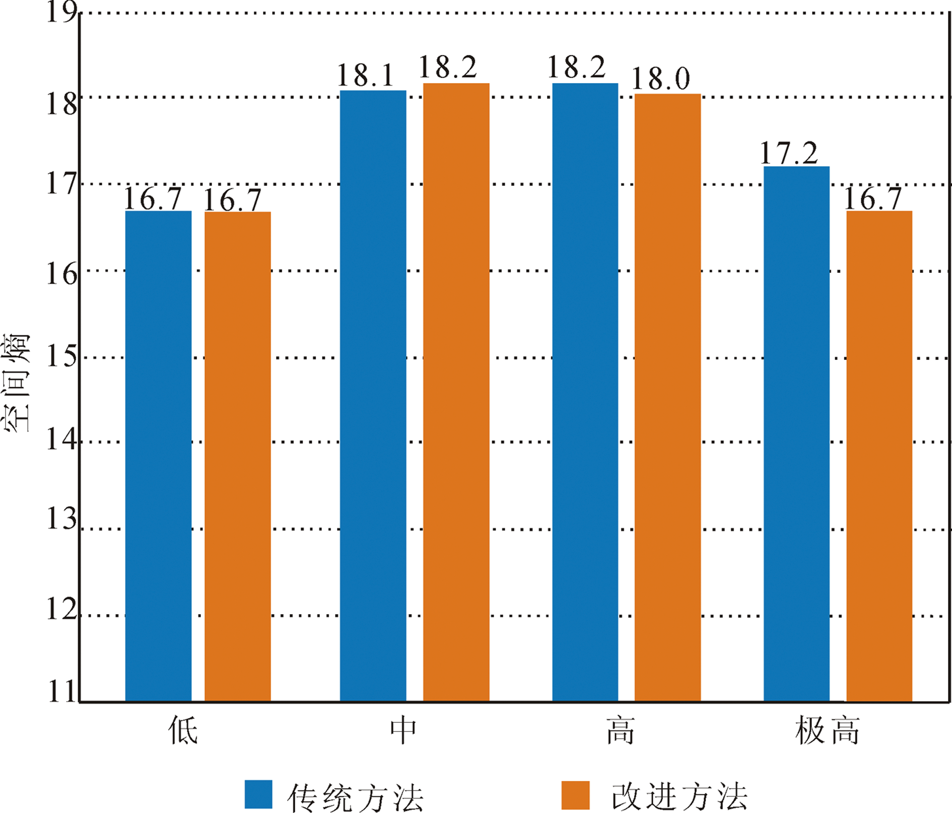
图20 川藏铁路沿线及邻区地质灾害易发性预测模型的空间熵
Fig.20 Spatial entropies of the geohazard susceptibilities along the Sichuan-Tibet Railway and its adjacent area assessed using the traditional and improved frequency ratio methods
| 易发性分区 | 面积/km2 | 占比/% |
|---|---|---|
| 极高 | 43 195.03 | 5.10 |
| 高 | 319 051.66 | 37.68 |
| 中 | 265 797.75 | 31.39 |
| 低 | 218 675.56 | 25.83 |
| 合计 | 846 720 | 100 |
表1 川藏铁路沿线及邻区不同地质灾害易发性分区面积及比例
Table 1 Areas and ratios of different geohazard susceptibility zones along the Sichuan-Tibet Railway and its adjacent area
| 易发性分区 | 面积/km2 | 占比/% |
|---|---|---|
| 极高 | 43 195.03 | 5.10 |
| 高 | 319 051.66 | 37.68 |
| 中 | 265 797.75 | 31.39 |
| 低 | 218 675.56 | 25.83 |
| 合计 | 846 720 | 100 |

图21 川藏铁路沿线及邻区地质灾害易发性分区图
Fig.21 Geohazard susceptibility zones along the Sichuan-Tibet Railway and its adjacent area
| [1] | 黄润秋. 20世纪以来中国的大型滑坡及其发生机制[J]. 岩石力学与工程学报, 2007, 26(3): 433-454. |
| [2] | 殷跃平. 西藏波密易贡高速巨型滑坡特征及减灾研究[J]. 水文地质工程地质, 2000, 27(4): 8-11. |
| [3] | 郭长宝, 杜宇本, 佟元清, 等. 青藏高原东缘理塘乱石包高速远程滑坡发育特征与形成机理[J]. 地质通报, 2015, 34(8): 1332-1345. |
| [4] | 王东辉, 肖红勇, 李明辉. 滑坡滑前地质模型重建方法与思路——以鲜水河断裂带老虎嘴滑坡为例[J]. 水文地质工程地质, 2013, 40(5): 111-116. |
| [5] | 郭长宝, 杜宇本, 张永双, 等. 川西鲜水河断裂带地质灾害发育特征与典型滑坡形成机理[J]. 地质通报, 2015, 34(1): 9-22. |
| [6] | 王珂, 郭长宝, 马施民, 等. 基于证据权模型的川西鲜水河断裂带滑坡易发性评价[J]. 现代地质, 2016, 30(3): 705-715. |
| [7] | 蒋德明, 李益敏, 鲍华姝. 泸水县滑坡孕灾环境因素敏感性研究[J]. 自然灾害学报, 2016, 25(4): 109-119. |
| [8] | 白永健, 铁永波, 倪化勇, 等. 鲜水河流域地质灾害时空分布规律及孕灾环境研究[J]. 灾害学, 2014, 29(4): 69-75. |
| [9] | 王宇丰. 遥感技术在川藏及滇藏铁路可行性研究中的应用[J]. 铁路航测, 1998(2): 31-34. |
| [10] | 西藏自治区地质环境监测总站. 西藏自治区1∶50万区域环境地质调查报告[R]. 拉萨: 西藏自治区地质环境监测总站, 2004. |
| [11] | 四川省地质工程勘察院. 四川省1∶50万环境地质图[R]. 成都: 四川省地质工程勘察院, 1999. |
| [12] |
CLERICI A, PEREGO S, TELLINI C, et al. A GIS-based automated procedure for landslide susceptibility mapping by the Conditional Analysis method: the Baganza valley case study (Italian Northern Apennines)[J]. Environmental Geology, 2006, 50(7): 941-961.
DOI URL |
| [13] |
GEMITZI A, FALALAKIS G, ESKIOGLOU P, et al. Evaluating landslide susceptibility using environmental factors, fuzzy membership functions and GIS[J]. Global NEST Journal, 2011, 13(1): 28-40.
DOI URL |
| [14] |
CHOI J, OH H J, LEE H J, et al. Combining landslide susceptibility maps obtained from frequency ratio, logistic regression, and artificial neural network models using ASTER images and GIS[J]. Engineering Geology, 2012, 124: 12-23.
DOI URL |
| [15] |
GUO C B, MONTGOMERY D R, ZHANG Y S, et al. Quantitative assessment of landslide susceptibility along the Xianshuihe fault zone, Tibetan Plateau, China[J]. Geomorphology, 2015, 248: 93-110.
DOI URL |
| [16] |
PRADHAN B, OH H J, BUCHROITHNER M. Weights-of-evidence model applied to landslide susceptibility mapping in a tropical hilly area[J]. Geomatics, Natural Hazards and Risk, 2010, 1(3): 199-223.
DOI URL |
| [17] | LEE S, PRADHAN B. Landslide hazard mapping at Selangor, Malaysia using frequency ratio and logistic regression models[J]. Landslides, 2007, 4(1): 33-41. |
| [18] |
YALCIN A, REIS S, AYDINOGLU A C, et al. A GIS-based comparative study of frequency ratio, analytical hierarchy process, bivariate statistics and logistics regression methods for landslide susceptibility mapping in Trabzon, NE Turkey[J]. Catena, 2011, 85(3): 274-287.
DOI URL |
| [19] |
MONDAL S, MAITI R. Integrating the analytical hierarchy process (AHP) and the frequency ratio (FR) model in landslide susceptibility mapping of Shiv-khola watershed, Darjeeling Himalaya[J]. International Journal of Disaster Risk Science, 2013, 4(4): 200-212.
DOI URL |
| [20] |
YILMAZ I. Landslide susceptibility using frequency ratio, logistic regression, artificial neural networks and their comparison: a case study from Kat landslides (Tokat-Turkey)[J]. Computers & Geosciences, 2009, 35(6): 1125-1138.
DOI URL |
| [21] |
ANBALAGAN R, KUMAR R, LAKSHMANAN K, et al. Landslide hazard zonation mapping using frequency ratio and fuzzy logic approach, a case study of Lachung Valley, Sikkim[J]. Geoenvironmental Disasters, 2015, 2: 6.
DOI URL |
| [22] |
LI L P, LAN H X, GUO C B, et al. A modified frequency ratio method for landslide susceptibility assessment[J]. Landslides, 2017, 14:727-741.
DOI URL |
| [23] |
HANLEY J A, MCNEIL B J. The meaning and use of the area under a receiver operating characteristic (ROC) curve[J]. Radiology, 1982, 143: 29-36.
DOI PMID |
| [24] |
MATHEW J, JHA V K, RAWAT G S. Landslide susceptibility zonation mapping and its validation in part of Garhwal Lesser Himalaya, India, using binary logistic regression analysis and receiver operating characteristic curve method[J]. Landslides, 2009, 6: 17-26.
DOI URL |
| [25] |
ERENER A, DÜZGÜN H S B. Improvement of statistical landslide susceptibility mapping by using spatial and global regression methods in the case of More and Romsdal (Norway)[J]. Landslides, 2010, 7: 55-68.
DOI URL |
| [26] |
AKGUN A. A comparison of landslide susceptibility maps produced by logistic regression, multi-criteria decision, and likelihood ratio methods: a case study at Zmir, Turkey[J]. Landslides, 2012, 9: 93-106.
DOI URL |
| [27] |
AHMED B. Landslide susceptibility mapping using multi-criteria evaluation techniques in Chittagong Metropolitan Area, Bangladesh[J]. Landslides, 2015, 12: 1077-1095.
DOI URL |
| [28] | 林宗涵. 热力学与统计物理学[M]. 北京: 北京大学出版社, 2007: 39-58. |
| [29] | GRAY R M. Entropy and Information Theory[M]. Second Edition. New York: Springer Science and Business Media, 2011: 61-95. |
| [30] |
许冲, 戴福初, 姚鑫, 等. 汶川地震滑坡在两个典型区域内的分布研究[J]. 中国科学院大学学报, 2010, 27(5): 621-631.
DOI |
| [1] | 李俊磊, 张绪教, 王一凡, 张向格, 王重歌, 袁晓宁, 刘心兰, 王凯雅, 饶昊舒, 刘江, 秦渊. 青海省化隆县地学研学旅行的路线规划与思考[J]. 现代地质, 2023, 37(05): 1411-1422. |
| [2] | 王瑞丰, 翟延亮, 张宝君, 申国强, 曾一凡. 基于GIS与AHP耦合技术的承德地区地质灾害危害性评价[J]. 现代地质, 2023, 37(04): 1023-1032. |
| [3] | 李信, 薛桂澄, 夏南, 柳长柱, 杨永鹏, 马波. 基于CF、CF-LR和CF-AHP模型的国家热带雨林公园地质灾害易发性研究:以海南保亭为例[J]. 现代地质, 2023, 37(04): 1033-1043. |
| [4] | 刘心兰, 张绪教, 李俊磊, 王一凡, 张向格, 袁晓宁, 王凯雅, 王重歌, 刘江, 侯恩刚. 青海化隆县独特的峡谷丹山地貌景观及其科学价值[J]. 现代地质, 2023, 37(01): 233-244. |
| [5] | 胡梦珺, 吉天琪, 郑登友, 庄静, 孙文丽, 许澳康. 9.4 ka以来青藏高原东北部风成沉积物色度参数变化特征及其环境演变[J]. 现代地质, 2022, 36(02): 439-448. |
| [6] | 方念乔. 关于“海陆对比”研究的若干实践和思考[J]. 现代地质, 2022, 36(01): 1-13. |
| [7] | 陈静, 李大鹏, 康欢, 耿建珍, 张菁菁. 滇西点苍山变质地体三叠纪至侏罗纪沉积岩碎屑锆石源区信息及构造指示[J]. 现代地质, 2021, 35(04): 883-913. |
| [8] | 郭长宝, 吴瑞安, 蒋良文, 钟宁, 王炀, 王栋, 张永双, 杨志华, 孟文, 李雪, 刘贵. 川藏铁路雅安—林芝段典型地质灾害与工程地质问题[J]. 现代地质, 2021, 35(01): 1-17. |
| [9] | 王家柱, 高延超, 冉涛, 铁永波, 张凡. 川藏铁路交通廊道某大型古滑坡成因及失稳模式分析[J]. 现代地质, 2021, 35(01): 18-25. |
| [10] | 闫怡秋, 杨志华, 张绪教, 孟少伟, 郭长宝, 吴瑞安, 张怡颖. 基于加权证据权模型的青藏高原东部巴塘断裂带滑坡易发性评价[J]. 现代地质, 2021, 35(01): 26-37. |
| [11] | 权雪瑞, 黄靥欢, 刘春, 郭长宝. 川藏铁路线V形深切河谷地形地震放大效应数值模拟[J]. 现代地质, 2021, 35(01): 38-46. |
| [12] | 李雪, 郭长宝, 杨志华, 廖维, 吴瑞安, 金继军, 何元宵. 金沙江断裂带雄巴巨型古滑坡发育特征与形成机理[J]. 现代地质, 2021, 35(01): 47-55. |
| [13] | 张佳佳, 高波, 刘建康, 陈龙, 黄海, 李杰. 基于SBAS-InSAR技术的川藏铁路澜沧江段滑坡隐患早期识别[J]. 现代地质, 2021, 35(01): 64-73. |
| [14] | 周杰, 丁明涛, 黄涛, 陈宁生. 基于虚拟现实技术的川藏铁路地质灾害易发区减灾选线优化:以洛隆车站为例[J]. 现代地质, 2021, 35(01): 92-102. |
| [15] | 王磊, 郭长宝, 郭朋瑜, 吉锋. 川藏铁路孜拉山区片麻岩蠕变特性及本构模型研究[J]. 现代地质, 2021, 35(01): 153-160. |
| 阅读次数 | ||||||
|
全文 |
|
|||||
|
摘要 |
|
|||||