

现代地质 ›› 2022, Vol. 36 ›› Issue (01): 1-13.DOI: 10.19657/j.geoscience.1000-8527.2021.171
方念乔( )
)
收稿日期:2021-12-10
修回日期:2021-12-24
出版日期:2022-02-10
发布日期:2022-03-08
作者简介:方念乔,男,教授,博士生导师,1950年出生,海洋地质专业,主要从事海洋地质、沉积地质和大地构造的科研与教学。Email: fangnq@cugb.edu.cn。
基金资助:
FANG Nianqiao()
Received:2021-12-10
Revised:2021-12-24
Online:2022-02-10
Published:2022-03-08
摘要:
通过剖析和总结两个重要的研究经历和学术成果:(1)应用东北印度洋的深海钻心研究喜马拉雅山—青藏高原隆升,(2)应用南海周边陆域的岩浆-沉积记录研究“古南海”的消亡和南海的早期开裂,作者阐释了对于这一特殊的“海陆对比”研究的理解、策划与心得体会。在前一项凭海观山的研究中,首先明确在东北印度洋区存在两类组分、成因各不相同的深海沉积序列,它们分别坐落于孟加拉海底扇和东经90°海岭,在响应山脉隆升的方式上各具优势。经过对两个序列的替代性指标的严格筛选与对比,确定3.6~3.2 Ma和1.0~0.6 Ma是晚中新世以来山脉与高原隆升影响最为深刻的关键时段。在第二项由陆识海的研究中,须要处理的则是较第一项更为复杂的包括岩浆、构造、沉积甚至陆上钻井在内的地质记录,而且其保存条件远逊深海沉积系列。此类研究的优势在于,可以避免单一钻孔记录的局限性,助力研究者在更广阔的区域内综合各种适用的基础材料,构建反映海陆一体化的区域构造演化框架。在华南大陆边缘,存在中生代晚期活动陆缘向新生代被动陆缘的重大构造转换。为建立一个完整的陆缘弧体系,作者于研究区布设了“十字形”考察路线,在东西向追索最初发现于海南的陆缘弧的展布特征,在南北向查明陆缘弧的结构样式,发现在白垩纪中期(110~80 Ma)发生强烈的因板块汇聚而产生的区域隆升,且由南向北隆升强度减弱。经过与同期浙闽陆缘岩浆-沉积记录的综合对比,认为中生代向北俯冲的“古南海”很可能属于业已消亡的特提斯域。中生代末华南陆缘进入全新的发展阶段,三水盆地因展现白垩纪—始新世规模最大且保存最好的岩浆-沉积过程被选为被动陆缘破裂研究的中心地区。古新世晚期(~57 Ma)以碱性玄武岩-粗面岩-钠闪碱流岩为代表的碱性系列双峰式火山喷发活动在研究区兴起,并一直持续到盆地停止发育(42~38 Ma)。实验数据显示:(1)岩浆源区位于软流圈地幔,即使喷发规模最大的粗面岩和碱流岩,也是来自幔源玄武质岩浆的分阶段结晶分异,(2)计算得到的地幔热异常并不明显。作者综合所得结果判断,研究区不存在主导区域构造运动的深源地幔柱,三水盆地发达的火山岩系产出的真实背景在于,中生代晚期的俯冲-碰撞使得岩石圈缩短加厚,于中新生代之交发生拆沉作用和软流圈上涌。这一区域构造环境不仅导致新生代早期的华南裂谷作用,很可能对其后的南海扩张也产生重要影响。现代地球科学将海和陆这两个最大的地理单元紧密地联系在一起,从海洋采集相关的地质信号研究大陆构造,抑或反之,都给我们提供了审视和解决科学问题的新的有效视窗。
中图分类号:
方念乔. 关于“海陆对比”研究的若干实践和思考[J]. 现代地质, 2022, 36(01): 1-13.
FANG Nianqiao. Practice and Thinking on the Study of “Sea-Land Correlation”[J]. Geoscience, 2022, 36(01): 1-13.

图1 研究区位置和主要工作-采样点
Fig.1 Map showing the locations of the study area and major working-sampling spots
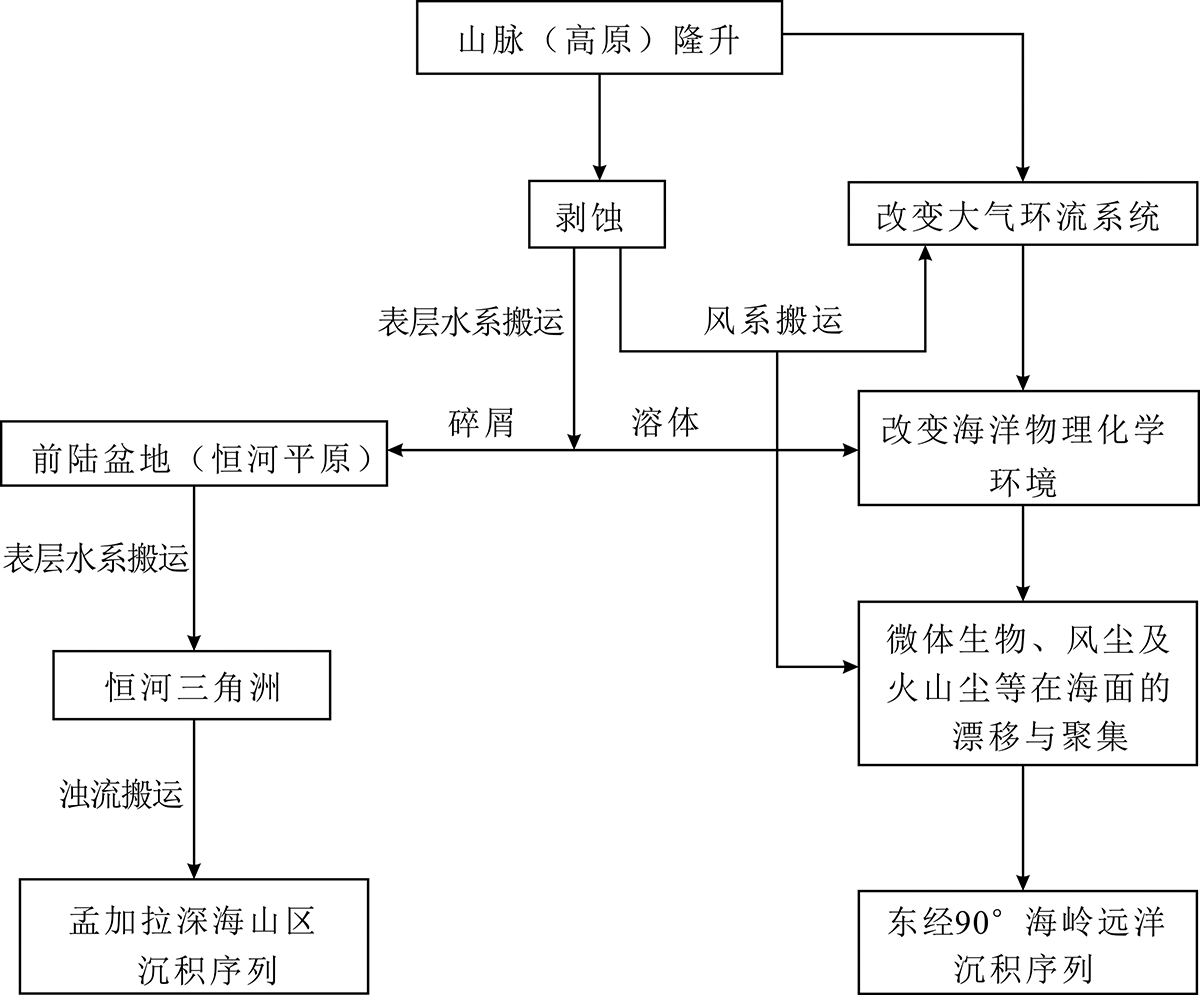
图2 东北印度洋区响应山脉(青藏高原)隆升信号的主要记录方式(据文献[18],有改动)
Fig.2 Main pattern of the signals recording uplifts of the Himalayan mountains (Tibetan Plateau) in Northeastern Indian Ocean (modified after ref. [18])

图3 晚中新世以来扇区和岭区代表性沉积记录主要指标的变化(据文献[18],有改动)
Fig.3 Variations of the main proxies from the sedimentary records of the fan and ridge areas since the Late Miocene (modified after ref. [18])

图4 华南南缘上白垩统花岗质磨拉石相野外露头 (a)三水芦苞镇;(b)清远杨梅屋;(c)中山黄圃;(d)茂名艾屋
Fig.4 Photos showing the granitic molasse outcrops in the southern margin of the South China

图5 三水组碎屑锆石年代分布
Fig.5 Age distribution of detrital zircons from the Sanshui Formation
| 时代 | 华南—南海陆缘 | 浙闽陆缘 |
|---|---|---|
| 中侏罗世晚期—早白垩世早期(165~135 Ma) | 惠东地区高基坪火山岩组合和丹霞地区玄武岩、安山岩均明确显示钙碱性特质。花岗质岩浆活动遍布中山、恩平、茂名、惠东等沿海地区及粤北—南岭一带,岩基主体呈东—西向展布,化学和矿物组分相近。典型如南岭者,被指认为高分异I型或S型花岗岩[ | 花岗质岩体主要分布在福建西部,呈NE—SW向展布; 同造山期NW—SE向挤压环境下下扬子区及海岸带出现大量埃达克质岩和变质花岗岩[ |
| 早白垩世(135~110 Ma) | 岩浆活动沉寂,各类岩浆岩记录稀少; 由众多中小型山间盆地形成,中粗碎屑磨拉石相较为发育 | 后造山期大规模伸展裂陷活动(136~118 Ma)和挤压走滑活动(117~108)交替进行[ 火山活动强烈,安山岩主要集中在早白垩世早—中期[ I型花岗岩居多,在浙江、苏南等地,出露含有碱性暗色矿物的典型A型花岗岩[ |
| 早白垩世晚期—晚白垩世中期(110~80 Ma) | 火山岩以中-酸性系列为主,安山岩广泛分布;花岗岩为I型和S型,指示挤压构造环境;有很多高镁安山岩和埃达克质岩出露,指示年轻洋壳的俯冲作用;粗面岩、流纹岩皆为钙碱性; 地壳普遍出现构造抬升,单组分岩屑(尤以花岗岩屑为最)砂砾岩广布,近源磨拉石相极为发育; 岩浆岩、沉积岩均指示由南向北陆缘活动强度递减 | WNW—ESE向伸展运动导致盆地沉陷,产生大量I型和A型花岗岩;双峰式火山岩以流纹岩为主,兼有少量玄武岩;未见高镁安山岩报道;出现复成分厚层块状粗碎屑岩[ |
| 晚白垩世中期—早古新世(80~60 Ma) | 岩浆活动减少,花岗岩体“小型化”,部分地区如珠江口盆地基底仍有I型花岗岩报道[ 部分地区如三水上白垩统大塱山组转为复成分砂砾岩,局部可见小型正断层 | 85 Ma后区域应力场由伸展转为压扭,岩浆活动停止[ |
表1 华南与浙闽陆缘晚中生代主要地质记录对比
Table 1 Correlation of major geological records between the south margin and Zhejiang-Fujian margin in China
| 时代 | 华南—南海陆缘 | 浙闽陆缘 |
|---|---|---|
| 中侏罗世晚期—早白垩世早期(165~135 Ma) | 惠东地区高基坪火山岩组合和丹霞地区玄武岩、安山岩均明确显示钙碱性特质。花岗质岩浆活动遍布中山、恩平、茂名、惠东等沿海地区及粤北—南岭一带,岩基主体呈东—西向展布,化学和矿物组分相近。典型如南岭者,被指认为高分异I型或S型花岗岩[ | 花岗质岩体主要分布在福建西部,呈NE—SW向展布; 同造山期NW—SE向挤压环境下下扬子区及海岸带出现大量埃达克质岩和变质花岗岩[ |
| 早白垩世(135~110 Ma) | 岩浆活动沉寂,各类岩浆岩记录稀少; 由众多中小型山间盆地形成,中粗碎屑磨拉石相较为发育 | 后造山期大规模伸展裂陷活动(136~118 Ma)和挤压走滑活动(117~108)交替进行[ 火山活动强烈,安山岩主要集中在早白垩世早—中期[ I型花岗岩居多,在浙江、苏南等地,出露含有碱性暗色矿物的典型A型花岗岩[ |
| 早白垩世晚期—晚白垩世中期(110~80 Ma) | 火山岩以中-酸性系列为主,安山岩广泛分布;花岗岩为I型和S型,指示挤压构造环境;有很多高镁安山岩和埃达克质岩出露,指示年轻洋壳的俯冲作用;粗面岩、流纹岩皆为钙碱性; 地壳普遍出现构造抬升,单组分岩屑(尤以花岗岩屑为最)砂砾岩广布,近源磨拉石相极为发育; 岩浆岩、沉积岩均指示由南向北陆缘活动强度递减 | WNW—ESE向伸展运动导致盆地沉陷,产生大量I型和A型花岗岩;双峰式火山岩以流纹岩为主,兼有少量玄武岩;未见高镁安山岩报道;出现复成分厚层块状粗碎屑岩[ |
| 晚白垩世中期—早古新世(80~60 Ma) | 岩浆活动减少,花岗岩体“小型化”,部分地区如珠江口盆地基底仍有I型花岗岩报道[ 部分地区如三水上白垩统大塱山组转为复成分砂砾岩,局部可见小型正断层 | 85 Ma后区域应力场由伸展转为压扭,岩浆活动停止[ |
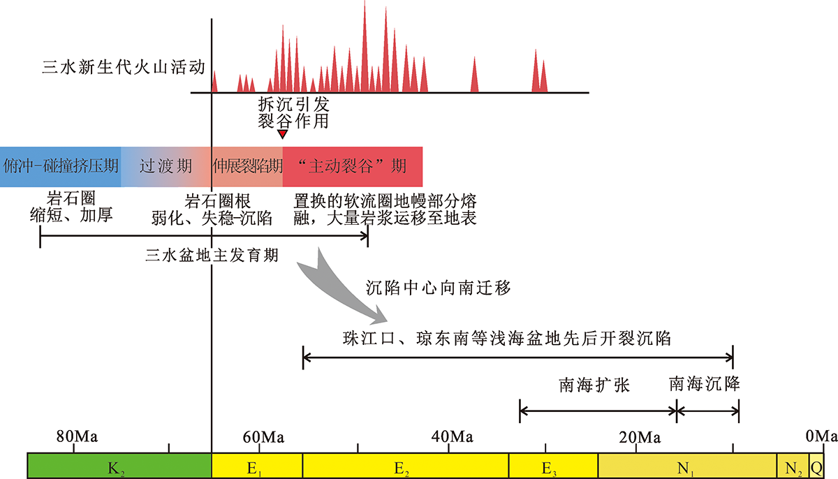
图6 三水盆地中—新生代演化模式及其与南海的关联
Fig.6 Evolutionary model of the Sanshui basin and its relationship with the South China Sea Opening
| [1] |
ALAM M, ALAM M M, CURRAY J R, et al. An overview of the sedimentary geology of the Bengal Basin in relation to the regional tectonic framework and basin-fill history[J]. Sedimentary Geology, 2003, 155(3/4): 179-208.
DOI URL |
| [2] |
BROZOVIC N, BURBANK D W. Dynamic fluvial systems and gravel progradation in the Himalayan foreland[J]. Geological Society of America Bulletin, 2000, 112(3): 394-412.
DOI URL |
| [3] | CORNER G. Geomorphology: A Systematic Analysis of Late Cenozoic Landforms[M]. 2nd ed. Englewood Cliffs: Prentice Hall, 1991. |
| [4] |
FITZSIMMONS R, BUCHANAN J, IZATT C. The role of outcrop geology in predicting reservoir presence in the Cretaceous and Paleocene successions of the Sulaiman Range, Pakistan[J]. AAPG Bulletin, 2005, 89(2): 231-254.
DOI URL |
| [5] | 施雅风, 汤懋苍, 马玉贞. 青藏高原二期隆升与亚洲季风孕育关系探讨[J]. 中国科学(D辑: 地球科学), 1998, 28(3): 263-271. |
| [6] |
ACHARYYA S K. Break-up of the greater indo-Australian continent and accretion of blocks framing south and east Asia[J]. Journal of Geodynamics, 1998, 26(1): 149-170.
DOI URL |
| [7] | 李吉均, 方小敏. 青藏高原隆起与环境变化研究[M]//中国科协. 中国科协首届学术年会论文集. 北京: 中国科学出版社, 1999: 308. |
| [8] | 孟祥化. 沉积盆地与建造层序[M]. 北京: 地质出版社, 1993. |
| [9] |
CURRAY J R, MOORE D G. Growth of the Bengal deep-sea fan and denudation in the Himalayas[J]. Geological Society of America Bulletin, 1971, 82(3): 563.
DOI URL |
| [10] | CURRAY J R, MOORE D G. Sedimentary and tectonic processes in the Bengal deep-sea fan and geosyncline[M]// The Geology of Continental Margins. Berlin, Heidelberg: Springer, 1974: 617-627. |
| [11] | MOORE D G, CURRAY J R, RAITT R W, et al. Stratigraphic-seismic section correlations and implications to Bengal fan history[M]// Deep Sea Drilling Project. Initial Reports of the Deep Sea Drilling Project.Washington:U.S.Government Printing Office, 1974:22. |
| [12] | CURRAY J R, EMMEL F J, MOORE D G, et al. Structure, tectonics, and geological history of the northeastern Indian ocean[M]// The Ocean Basins and Margins. Boston: Springer, 1982: 399-450. |
| [13] | COCHRAN J R. Himalayan uplift, sea level, and the record of Bengal fan sedimentation at the ODP leg 116 sites[M]//Ocean Drilling Program. Proceedings of the Ocean Drilling Program. Tulsa: Ocean Drilling Program, 1990: 397-414. |
| [14] | STOW D. Sediment facies and processes on the distal Bengal Fan, Leg 116[M]. Proceedings of the Ocean Drilling Program. Tulsa: Ocean Drilling Program, 1990: 377-396. |
| [15] |
FRANCE-LANORD C, DERRY L, MICHARD A. Evolution of the Himalaya since Miocene time: Isotopic and sedimentological evidence from the Bengal Fan[J]. Geological Society, London, Special Publications, 1993, 74(1): 603-621.
DOI URL |
| [16] | THOMPSON R W. Mineralogy of sands from the Bengal and Nicobar fans, sites 218 and 211, eastern Indian Ocean[M]// Ocean Drilling Program. Initial Reports of the Deep Sea Drilling Project. Washington: U.S.Government Printing Office, 1974: 711-713. |
| [17] | 方念乔, 陈学方, 胡超涌, 等. 东北印度洋深海记录基本特征及其对青藏高原隆升的响应[J]. 第四纪研究, 2001, 21(6): 490-499. |
| [18] | 方念乔, 丁旋, 张振国, 等. 东北印度洋两类主要的深水沉积序列及其对喜马拉雅隆升的响应[J]. 地质科学, 2009, 44(4): 1181-1198. |
| [19] | 方念乔, 丁旋, 刘勇勤, 等. 东经90°海岭的远洋沉积记录与晚新生代重大构造环境事件[J]. 地学前缘, 2002, 9(1): 103-111. |
| [20] | KROON D, STEENS T N F, TROELSTRA S R. Onset of monsoonal related upwelling in the western Arabian sea as revealed by planktonic foraminifers[M]// Ocean Drilling Program. Proceedings of the Ocean Drilling Program, 117 Scientific Results. Tulsa: Ocean Drilling Program, 1991: 257-263. |
| [21] |
PRELL W L, KUTZBACH J E. Sensitivity of the Indian monsoon to forcing parameters and implications for its evolution[J]. Nature, 1992, 360: 647-652.
DOI URL |
| [22] |
TRIPATHI S, TIWARI M, LEE J, et al. First evidence of denitrification vis-à-vis monsoon in the Arabian Sea since Late Miocene[J]. Scientific Reports, 2017, 7: 43056.
DOI URL |
| [23] |
HUTCHISON C S. Ophiolite in southeast Asia[J]. Geological Society of America Bulletin, 1975, 86(6): 797.
DOI URL |
| [24] |
RANGIN C, BELLON H, BENARD F, et al. Neogene arc-continent collision in Sabah, Northern Borneo (Malaysia)[J]. Tectonophysics, 1990, 183(1/2/3/4): 305-319.
DOI URL |
| [25] |
FAURE M, MARCHADIER Y, RANGIN C. Pre-Eocene synmetamorphic structure in the Mindoro-Romblon-Palawan area, west Philippines, and implications for the history of Southeast Asia[J]. Tectonics, 1989, 8(5): 963-979.
DOI URL |
| [26] | LEE C T A, MORTON D M, KISTLER R W, et al. Petrology and tectonics of Phanerozoic continent formation: From island arcs to accretion and continental arc magmatism[J]. Earth and Pla-netary Science Letters, 2007, 263(3/4): 370-387. |
| [27] | 方念乔. “海南陆缘弧”体系的构建与“特提斯南海”的识别: 一个关于“古南海”演化新模式的探讨[J]. 地学前缘, 2016, 23(6): 107-119. |
| [28] | 陈卫锋, 陈培荣, 徐夕生, 等. 华南白垩纪玄武质岩石的地球化学特征及其对太平洋板块俯冲作用的制约[J]. 中国科学(D辑: 地球科学), 2005, 35(11): 1007-1018. |
| [29] | 孙卫东, 林秋婷, 张丽鹏, 等. 跳出南海看南海: 新特提斯洋闭合与南海的形成演化[J]. 岩石学报, 2018, 34(12): 3467-3478. |
| [30] | 刘洋. “海南陆缘弧”延展问题研究[D]. 北京: 中国地质大学(北京), 2020. |
| [31] | 李平鲁, 梁慧娴, 戴一丁, 等. 珠江口盆地燕山期岩浆岩的成因及构造环境[J]. 广东地质, 1999, 14(1): 1-8. |
| [32] |
LIU Y, FANG N Q, QIANG M L, et al. The Cretaceous igneous rocks in southeastern Guangxi and their implication for tectonic environment in southwestern South China Block[J]. Open Geosciences, 2020, 12(1): 518-531.
DOI URL |
| [33] | 刘洋, 方念乔, 强萌麟, 等. 粤桂地区白垩纪中期安山岩年代学、地球化学特征及其构造意义[J]. 现代地质, 2021, 35(4): 968-980. |
| [34] | 强萌麟. 南海北部陆缘白垩纪安山岩基本特征及其与东南沿海安山岩对比[D]. 北京: 中国地质大学(北京), 2016. |
| [35] | 姚伯初, 万玲. 中国南海海域岩石圈三维结构及演化[M]. 北京: 地质出版社, 2006. |
| [36] | 钟建华, 张琴华. 衡阳盆地的准同生砾石与盆地构造反转[J]. 岩相古地理, 1995, 15(4): 43-46. |
| [37] | 吴福元, 刘小驰, 纪伟强, 等. 高分异花岗岩的识别与研究[J]. 中国科学: 地球科学, 2017, 47(7): 745-765. |
| [38] |
LI J H, ZHANG Y Q, DONG S W, et al. Cretaceous tectonic evolution of South China: A preliminary synthesis[J]. Earth-Science Reviews, 2014, 134: 98-136.
DOI URL |
| [39] | 张龙坤. 浙江嵊州白垩纪火山岩地质特征及构造环境[D]. 成都: 成都理工大学, 2018. |
| [40] | 邱检生, 王德滋, 彭亚鸣, 等. 浙江舟山桃花岛碱性花岗岩的岩石学和地球化学特征及成因探讨[J]. 南京大学学报(自然科学版), 1996, 32(1): 82-91. |
| [41] | 邱检生, 王德滋, 蟹泽聪史, 等. 福建沿海铝质A型花岗岩的地球化学及岩石成因[J]. 地球化学, 2000, 29(4): 313-321. |
| [42] |
WONG J, SUN M, XING G F, et al. Geochemical and zircon U-Pb and Hf isotopic study of the Baijuhuajian metaluminous A-type granite: Extension at 125-100 Ma and its tectonic significance for South China[J]. Lithos, 2009, 112(3/4): 289-305.
DOI URL |
| [43] |
ZHAO X L, JIANG Y, XING G F, et al. A geochemical and geochronological study of the Early Cretaceous, extension-related Honggong ferroan (A-type) granite in southwestern Zhejiang Province, southeast China[J]. Geological Magazine, 2018, 155(3): 549-567.
DOI URL |
| [44] | 侯明才, 林良彪, 陈洪德. 广东三水盆地沉积构造演化[M]. 北京: 地质出版社, 2010: 1-85. |
| [45] | 唐忠驭. 广东三水盆地白垩纪-早第三纪裂谷型火山作用[J]. 广东地质, 1994, 9(1): 9. |
| [46] |
CHUNG S L, CHENG H, JAHN B M, et al. Major and trace element, and Sr-Nd isotope constraints on the origin of Paleogene volcanism in South China prior to the South China Sea opening[J]. Lithos, 1997, 40(2/3/4): 203-220.
DOI URL |
| [47] | 肖龙, 周海民, 董月霞, 等. 广东三水盆地火山岩: 地球化学特征及成因: 兼论火山岩性质的时空演化和南海形成的深部过程[J]. 大地构造与成矿学, 2006, 30(1): 72-81. |
| [48] | 董月霞, 肖龙, 周海民, 等. 广东三水盆地双峰式火山岩: 空间展布、岩石学特征及其盆地动力学意义[J]. 大地构造与成矿学, 2006, 30(1): 82-92. |
| [49] | 张维, 方念乔. 广东三水盆地始新世火山岩地球化学特征[J]. 地球科学, 2014, 39(1): 37-44. |
| [50] | 张煜, 方念乔. 广东三水盆地玄武岩源区特征与南海早期演化[J]. 海洋地质与第四纪地质, 2021, 41(3): 95-113. |
| [51] |
CHEN Peijia, FANG Nianqiao, YUAN Xiaobo. Geochemical insights from clinopyroxene phenocrysts into the magma evolution of an alkaline magmatic system from the Sanshui Basin, South China[J]. Minerals, 2021, 11(11):1295.
DOI URL |
| [1] | 刘洋, 方念乔, 强萌麟, 贾磊, 宋超杰. 粤桂地区白垩纪中期安山岩年代学、地球化学特征及其构造意义[J]. 现代地质, 2021, 35(04): 968-980. |
| [2] | 滕田田, 苏新, 刘浩东, 崔鸿鹏, 陈芳, 程思海, 杨胜雄, 王宏斌, 梁金强, 苏丕波. 南海东沙深海冷泉区973-5重力柱沉积物古菌多样性[J]. 现代地质, 2020, 34(01): 104-116. |
| [3] | 冯常茂,王后金,解习农,张成. 南海南、北大陆边缘盆地烃源岩热演化差异及成因分析[J]. 现代地质, 2015, 29(1): 98-108. |
| [4] | 陈芳,庄畅,周洋,吴聪,陆红锋,刘坚,苏新,刘广虎. 南海神狐海域MIS12期以来的碳酸盐旋回与水合物分解[J]. 现代地质, 2015, 29(1): 145-154. |
| [5] | 贾佳林1,2,3, 张郁1,2, 李刚1,2, 陈朝阳1,2,. 南海海泥中甲烷水合物生成特性的实验研究[J]. 现代地质, 2013, 27(6): 1373-1378. |
| [6] | 张英,郭依群,莫午零,胡玉波. 南海北部水合物中天然气成因及形成条件[J]. 现代地质, 2013, 27(5): 1180-1185. |
| [7] | 李华 ,王英民 ,徐强 ,韩自亮,徐艳霞. 深水单向迁移水道-堤岸沉积体系特征及形成过程[J]. 现代地质, 2013, 27(3): 653-661. |
| [8] | 徐少华,徐国强,杨俊华,李小刚,胡琏,蔡长娥,郭伟. 南海北部白云凹陷深水区SQ13.8深水扇砂体识别与分布研究:以SF-5为例[J]. 现代地质, 2013, 27(2): 366-372. |
| [9] | 李淑玲, 孟小红, 郭良辉, 姚长利. 南海重力异常特征及其显著的构造意义[J]. 现代地质, 2012, 26(6): 1154-1161. |
| [10] | 武粤, 孟小红, 刘国峰. 南海北部缘重力异常的多尺度分析及其构造讨论[J]. 现代地质, 2012, 26(6): 1162-1167. |
| [11] | 杨木壮,沙志彬,梁金强,王宏斌,张光学. 南海东北部陆坡区天然气水合物成矿作用[J]. 现代地质, 2011, 25(2): 340-348. |
| [12] | 刘震, 张功成, 吕睿, 沈怀磊, 郭瑞, 田继先. 南海北部深水区白云凹陷渐新世晚期多物源充填特征[J]. 现代地质, 2010, 24(5): 900-909. |
| [13] | 吴时国 ,龚跃华,米立军,王志君,王秀娟. 南海北部深水盆地油气渗漏系统及天然气水合物成藏机制研究[J]. 现代地质, 2010, 24(3): 433-440. |
| [14] | 栾锡武, 张亮, 岳保静. 南海北部陆坡海底火山活动对天然气水合物成藏的影响[J]. 现代地质, 2010, 24(3): 424-432. |
| [15] | 王力峰, 沙志彬, 梁金强, 陆敬安. 晚期泥底辟控制作用导致神狐海域SH5钻位未获水合物的分析[J]. 现代地质, 2010, 24(3): 450-456. |
| 阅读次数 | ||||||
|
全文 |
|
|||||
|
摘要 |
|
|||||