

现代地质 ›› 2017, Vol. 31 ›› Issue (03): 574-586.
彭媛媛1( ), 康志宏1,2(), 李伟奇1, 韩慧宇1, 谭龙1
收稿日期:2016-10-05
修回日期:2016-11-20
出版日期:2017-06-10
发布日期:2017-06-27
通讯作者:
康志宏,男,教授,1966年出生,石油地质学专业,主要从事油气资源勘查与碳酸盐岩储层评价等方面的教学和科研工作。Email:kangzh98@163.com。
作者简介:彭媛媛,女,硕士研究生,1993年出生,矿产普查与勘探专业,主要从事沉积学理论与应用方面的工作。Email:854946290@qq.com。
基金资助:
PENG Yuanyuan1(), KANG Zhihong1,2(), LI Weiqi1, HAN Huiyu1, TAN Long1
Received:2016-10-05
Revised:2016-11-20
Online:2017-06-10
Published:2017-06-27
摘要:
对武威盆地及其周缘区石炭系的臭牛沟组和羊虎沟组沉积泥页岩样品进行了主量元素、微量元素以及稀土元素的综合分析,并讨论其结果对物源、风化剥蚀程度及构造背景的指示意义。研究发现武威盆地石炭系泥页岩元素特征如下:(1)主量元素中富含SiO2、Al2O3,亏损MgO、Fe2O3;(2)微量元素上地壳标准化曲线呈规律性的变化,U、Th、Cr等元素富集,Ba、Nb、Zr等亏损;(3)稀土元素(REE)分布模式与上地壳基本一致,整体表现为右倾型,轻稀土(LREE)富集,重稀土(HREE)均一稳定,Eu负异常;上述特征均反映了源岩主要来自上地壳。风化指数(CIA)值为68.81~90.17,平均值为83.9,反映了研究区遭受了中等的风化作用;臭牛沟剖面CIA平均值为84.81,红水堡剖面CIA平均值为83.51,表明研究区西部较东部所遭受的风化作用相对较强。主量元素比值、微量及稀土元素图解等分析反映了研究区源岩为长英质岩石,以中酸性花岗岩、碱性玄武岩为主。根据SiO2-K2O/Na2O、La-Th-Sc和Th-Co-Zr/10判别图解以及Ce异常值分析,认为石炭系源区的构造背景倾向于被动大陆边缘。通过研究区东西对比分析,发现盆地西部臭牛沟剖面石炭系为陇西古陆与阿拉善古陆混合物源,而东部红水堡剖面物源仅来源于陇西古陆。
中图分类号:
彭媛媛, 康志宏, 李伟奇, 韩慧宇, 谭龙. 武威盆地石炭系泥页岩元素地球化学特征及意义[J]. 现代地质, 2017, 31(03): 574-586.
PENG Yuanyuan, KANG Zhihong, LI Weiqi, HAN Huiyu, TAN Long. Element Geochemical Characteristics of Carboniferous Shale in Wuwei Basin and Its Significance[J]. Geoscience, 2017, 31(03): 574-586.
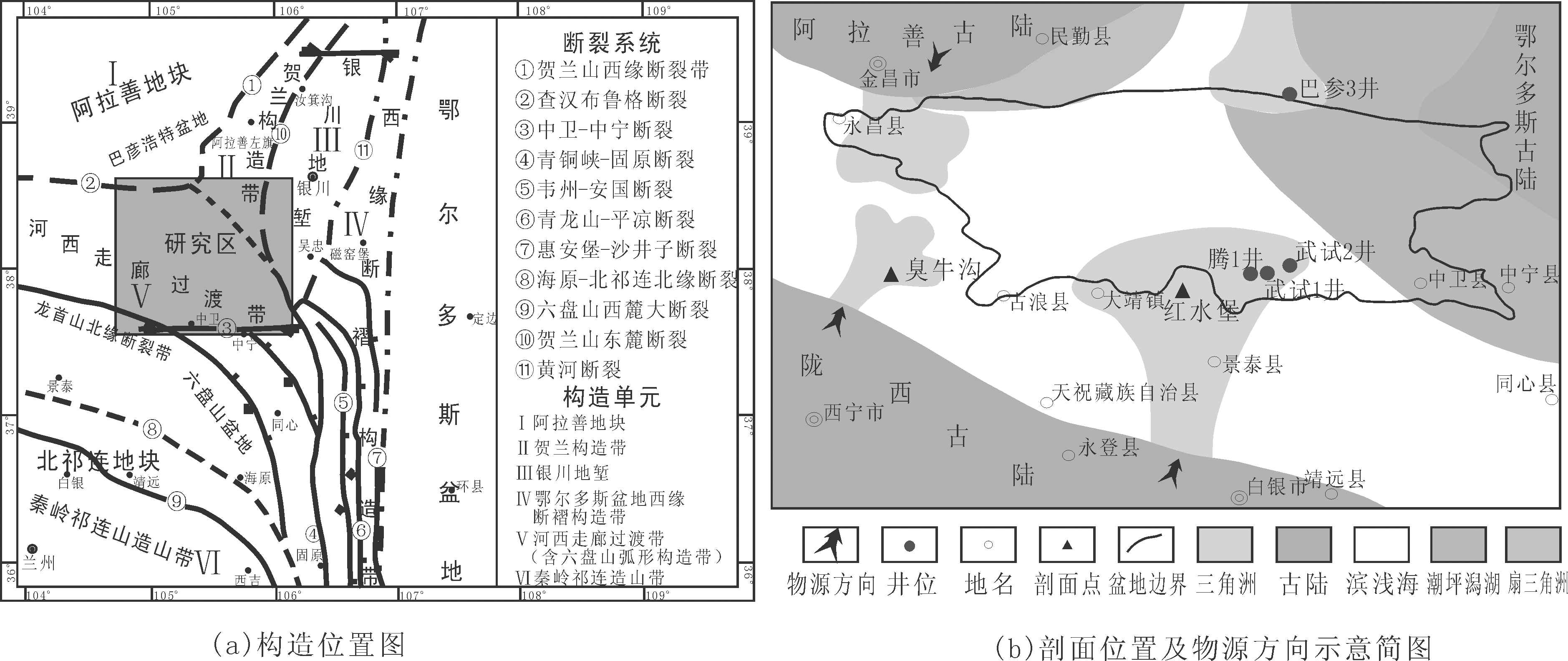
图1 研究区构造位置及物源示意简图((a)据张参修改)
Fig.1 Tectonic location and provenance of study area

图2 研究区红水堡与臭牛沟剖面采样点图((a)红水堡,(b)臭牛沟)
Fig.2 Sample locations of Hongshuipu section and Chouniugou section in study area
| 剖面 | 样品号 | 岩性 | SiO2 | Al2O3 | Fe2O3 | MgO | CaO | Na2O | K2O | MnO | TiO2 | P2O5 | K2O/ Na2O | Fe2O3+ MgO | Al2O3/ SiO2 | K2O/(Na2O +CaO) | Al2O3/(CaO+ Na2O) | ICV | CIA |
|---|---|---|---|---|---|---|---|---|---|---|---|---|---|---|---|---|---|---|---|
| 臭 牛 沟 | C1c-03 | 泥岩 | 59.38 | 24.67 | 1.43 | 0.732 | 0.182 | 0.212 | 4.14 | 0.005 | 1.14 | 0.049 | 19.53 | 2.16 | 0.42 | 10.51 | 62.61 | 0.32 | 82.70 |
| C2y-05 | 页岩 | 37.40 | 14.56 | 2.42 | 1.02 | 20.33 | 0.227 | 2.1 | 0.074 | 0.594 | 0.033 | 9.25 | 3.44 | 0.39 | 0.1 | 0.71 | 1.84 | 82.82 | |
| C2y-09 | 页岩 | 53.78 | 24.53 | 5.68 | 1.26 | 0.501 | 0.237 | 3.39 | 0.01 | 0.883 | 0.268 | 14.3 | 6.94 | 0.46 | 4.59 | 33.24 | 0.49 | 84.65 | |
| C2y-10 | 页岩 | 71.05 | 14.45 | 2.95 | 0.536 | 0.42 | 0.149 | 2.56 | 0.006 | 0.949 | 0.128 | 17.18 | 3.49 | 0.2 | 4.5 | 25.4 | 0.52 | 81.59 | |
| C2y-11 | 页岩 | 55.40 | 25.65 | 3.08 | 0.89 | 0.401 | 0.148 | 3.21 | 0.005 | 1 | 0.158 | 21.69 | 3.97 | 0.46 | 5.85 | 46.72 | 0.34 | 86.62 | |
| C2y-13 | 页岩 | 58.44 | 21.68 | 1.82 | 0.588 | 0.392 | 0.154 | 3.07 | 0.004 | 1.09 | 0.285 | 19.94 | 2.41 | 0.37 | 5.62 | 39.71 | 0.33 | 84.99 | |
| C2y-14 | 页岩 | 78.67 | 10.23 | 1.05 | 0.227 | 0.103 | 0.082 | 0.843 | 0.006 | 0.675 | 0.025 | 10.28 | 1.28 | 0.13 | 4.56 | 55.3 | 0.29 | 89.64 | |
| C2y-15 | 页岩 | 51.49 | 18.73 | 2.57 | 0.434 | 0.154 | 0.342 | 2.17 | 0.009 | 0.806 | 0.067 | 6.35 | 3 | 0.36 | 4.38 | 37.76 | 0.35 | 85.44 | |
| 红 水 堡 | C1c-08 | 页岩 | 71.1 | 13.81 | 1.13 | 0.545 | 0.268 | 0.353 | 1.64 | 0.006 | 0.905 | 0.068 | 4.65 | 1.68 | 0.19 | 2.64 | 22.24 | 0.35 | 82.93 |
| C1c-09 | 页岩 | 54.37 | 25.89 | 3.44 | 1.1 | 0.269 | 0.54 | 3.11 | 0.023 | 0.895 | 0.153 | 5.76 | 4.54 | 0.48 | 3.84 | 32 | 0.36 | 84.51 | |
| C1c-12 | 页岩 | 53.22 | 26.56 | 3.31 | 1.2 | 0.34 | 0.269 | 3.4 | 0.032 | 0.996 | 0.172 | 12.64 | 4.51 | 0.5 | 5.58 | 43.61 | 0.36 | 85.33 | |
| C1c-15 | 页岩 | 58.09 | 23.12 | 1.46 | 0.679 | 0.229 | 0.613 | 2.3 | 0.005 | 1.14 | 0.119 | 3.75 | 2.14 | 0.4 | 2.73 | 27.46 | 0.28 | 85.52 | |
| C2y-17 | 页岩 | 43 | 11.61 | 15.7 | 0.424 | 0.274 | 2.1 | 1.21 | 0.006 | 0.661 | 0.232 | 0.58 | 16.12 | 0.27 | 0.51 | 4.89 | 1.75 | 68.81 | |
| C2y-18 | 页岩 | 39.52 | 14.88 | 16.03 | 0.49 | 0.143 | 2.02 | 1.58 | 0.005 | 0.86 | 0.24 | 0.78 | 16.52 | 0.38 | 0.73 | 6.88 | 1.42 | 73.76 | |
| C2y-19 | 页岩 | 52.03 | 21.44 | 5.64 | 0.768 | 0.167 | 0.575 | 2.81 | 0.006 | 0.943 | 0.092 | 4.89 | 6.41 | 0.41 | 3.79 | 28.89 | 0.51 | 83.32 | |
| C2y-20 | 页岩 | 54.69 | 21.18 | 1.44 | 0.695 | 0.213 | 0.217 | 1.94 | 0.005 | 1.22 | 0.071 | 8.94 | 2.14 | 0.39 | 4.51 | 49.26 | 0.27 | 88.27 | |
| C2y-21 | 页岩 | 80.73 | 8.79 | 0.758 | 0.25 | 0.261 | 0.105 | 0.675 | 0.004 | 0.617 | 0.025 | 6.43 | 1.01 | 0.11 | 1.84 | 24.02 | 0.3 | 89.09 | |
| C2y-22 | 页岩 | 59.42 | 21.08 | 2.27 | 0.785 | 0.228 | 0.186 | 2.92 | 0.006 | 1.01 | 0.113 | 15.7 | 3.06 | 0.35 | 7.05 | 50.92 | 0.35 | 84.82 | |
| C2y-23 | 页岩 | 52.61 | 18.29 | 4.07 | 0.838 | 0.241 | 0.195 | 3.07 | 0.006 | 1.05 | 0.091 | 15.74 | 4.91 | 0.35 | 7.04 | 41.95 | 0.52 | 82.19 | |
| C2y-24 | 页岩 | 70.04 | 17.66 | 1.14 | 0.358 | 0.211 | 0.098 | 1.48 | 0.006 | 0.907 | 0.056 | 15.1 | 1.5 | 0.25 | 4.79 | 57.15 | 0.24 | 90.17 | |
| C2y-26 | 页岩 | 56.45 | 25.39 | 1.39 | 0.743 | 0.291 | 0.196 | 3.13 | 0.006 | 0.999 | 0.083 | 15.97 | 2.13 | 0.45 | 6.43 | 52.14 | 0.27 | 86.29 | |
| C2y-27 | 页岩 | 52.17 | 21.25 | 3.78 | 0.644 | 0.361 | 0.273 | 2.6 | 0.006 | 0.956 | 0.12 | 9.52 | 4.42 | 0.41 | 4.1 | 33.52 | 0.41 | 85.13 | |
| C2y-28 | 页岩 | 53.9 | 28.04 | 1.49 | 0.698 | 0.163 | 0.239 | 3.46 | 0.006 | 0.98 | 0.14 | 14.48 | 2.19 | 0.52 | 8.61 | 69.75 | 0.25 | 86.34 | |
| C2y-29 | 页岩 | 51.59 | 26.44 | 1.99 | 0.774 | 0.522 | 0.212 | 2.99 | 0.005 | 1.01 | 0.097 | 14.1 | 2.76 | 0.51 | 4.07 | 36.02 | 0.28 | 87.05 | |
| 平均值 | 57.02 | 20 | 3.585 | 0.695 | 1.111 | 0.406 | 2.492 | 0.011 | 0.929 | 0.12 | 11.15 | 4.28 | 0.36 | 4.52 | 36.76 | 0.52 | 84.25 | ||
表1 武威盆地石炭系臭牛沟—羊虎沟组泥页岩样品主量元素测试结果(%)
Table 1 Major elements compositions of Carboniferous shale from Chouniugou Formation-Yanghugou Formation of Wuwei Basin(%)
| 剖面 | 样品号 | 岩性 | SiO2 | Al2O3 | Fe2O3 | MgO | CaO | Na2O | K2O | MnO | TiO2 | P2O5 | K2O/ Na2O | Fe2O3+ MgO | Al2O3/ SiO2 | K2O/(Na2O +CaO) | Al2O3/(CaO+ Na2O) | ICV | CIA |
|---|---|---|---|---|---|---|---|---|---|---|---|---|---|---|---|---|---|---|---|
| 臭 牛 沟 | C1c-03 | 泥岩 | 59.38 | 24.67 | 1.43 | 0.732 | 0.182 | 0.212 | 4.14 | 0.005 | 1.14 | 0.049 | 19.53 | 2.16 | 0.42 | 10.51 | 62.61 | 0.32 | 82.70 |
| C2y-05 | 页岩 | 37.40 | 14.56 | 2.42 | 1.02 | 20.33 | 0.227 | 2.1 | 0.074 | 0.594 | 0.033 | 9.25 | 3.44 | 0.39 | 0.1 | 0.71 | 1.84 | 82.82 | |
| C2y-09 | 页岩 | 53.78 | 24.53 | 5.68 | 1.26 | 0.501 | 0.237 | 3.39 | 0.01 | 0.883 | 0.268 | 14.3 | 6.94 | 0.46 | 4.59 | 33.24 | 0.49 | 84.65 | |
| C2y-10 | 页岩 | 71.05 | 14.45 | 2.95 | 0.536 | 0.42 | 0.149 | 2.56 | 0.006 | 0.949 | 0.128 | 17.18 | 3.49 | 0.2 | 4.5 | 25.4 | 0.52 | 81.59 | |
| C2y-11 | 页岩 | 55.40 | 25.65 | 3.08 | 0.89 | 0.401 | 0.148 | 3.21 | 0.005 | 1 | 0.158 | 21.69 | 3.97 | 0.46 | 5.85 | 46.72 | 0.34 | 86.62 | |
| C2y-13 | 页岩 | 58.44 | 21.68 | 1.82 | 0.588 | 0.392 | 0.154 | 3.07 | 0.004 | 1.09 | 0.285 | 19.94 | 2.41 | 0.37 | 5.62 | 39.71 | 0.33 | 84.99 | |
| C2y-14 | 页岩 | 78.67 | 10.23 | 1.05 | 0.227 | 0.103 | 0.082 | 0.843 | 0.006 | 0.675 | 0.025 | 10.28 | 1.28 | 0.13 | 4.56 | 55.3 | 0.29 | 89.64 | |
| C2y-15 | 页岩 | 51.49 | 18.73 | 2.57 | 0.434 | 0.154 | 0.342 | 2.17 | 0.009 | 0.806 | 0.067 | 6.35 | 3 | 0.36 | 4.38 | 37.76 | 0.35 | 85.44 | |
| 红 水 堡 | C1c-08 | 页岩 | 71.1 | 13.81 | 1.13 | 0.545 | 0.268 | 0.353 | 1.64 | 0.006 | 0.905 | 0.068 | 4.65 | 1.68 | 0.19 | 2.64 | 22.24 | 0.35 | 82.93 |
| C1c-09 | 页岩 | 54.37 | 25.89 | 3.44 | 1.1 | 0.269 | 0.54 | 3.11 | 0.023 | 0.895 | 0.153 | 5.76 | 4.54 | 0.48 | 3.84 | 32 | 0.36 | 84.51 | |
| C1c-12 | 页岩 | 53.22 | 26.56 | 3.31 | 1.2 | 0.34 | 0.269 | 3.4 | 0.032 | 0.996 | 0.172 | 12.64 | 4.51 | 0.5 | 5.58 | 43.61 | 0.36 | 85.33 | |
| C1c-15 | 页岩 | 58.09 | 23.12 | 1.46 | 0.679 | 0.229 | 0.613 | 2.3 | 0.005 | 1.14 | 0.119 | 3.75 | 2.14 | 0.4 | 2.73 | 27.46 | 0.28 | 85.52 | |
| C2y-17 | 页岩 | 43 | 11.61 | 15.7 | 0.424 | 0.274 | 2.1 | 1.21 | 0.006 | 0.661 | 0.232 | 0.58 | 16.12 | 0.27 | 0.51 | 4.89 | 1.75 | 68.81 | |
| C2y-18 | 页岩 | 39.52 | 14.88 | 16.03 | 0.49 | 0.143 | 2.02 | 1.58 | 0.005 | 0.86 | 0.24 | 0.78 | 16.52 | 0.38 | 0.73 | 6.88 | 1.42 | 73.76 | |
| C2y-19 | 页岩 | 52.03 | 21.44 | 5.64 | 0.768 | 0.167 | 0.575 | 2.81 | 0.006 | 0.943 | 0.092 | 4.89 | 6.41 | 0.41 | 3.79 | 28.89 | 0.51 | 83.32 | |
| C2y-20 | 页岩 | 54.69 | 21.18 | 1.44 | 0.695 | 0.213 | 0.217 | 1.94 | 0.005 | 1.22 | 0.071 | 8.94 | 2.14 | 0.39 | 4.51 | 49.26 | 0.27 | 88.27 | |
| C2y-21 | 页岩 | 80.73 | 8.79 | 0.758 | 0.25 | 0.261 | 0.105 | 0.675 | 0.004 | 0.617 | 0.025 | 6.43 | 1.01 | 0.11 | 1.84 | 24.02 | 0.3 | 89.09 | |
| C2y-22 | 页岩 | 59.42 | 21.08 | 2.27 | 0.785 | 0.228 | 0.186 | 2.92 | 0.006 | 1.01 | 0.113 | 15.7 | 3.06 | 0.35 | 7.05 | 50.92 | 0.35 | 84.82 | |
| C2y-23 | 页岩 | 52.61 | 18.29 | 4.07 | 0.838 | 0.241 | 0.195 | 3.07 | 0.006 | 1.05 | 0.091 | 15.74 | 4.91 | 0.35 | 7.04 | 41.95 | 0.52 | 82.19 | |
| C2y-24 | 页岩 | 70.04 | 17.66 | 1.14 | 0.358 | 0.211 | 0.098 | 1.48 | 0.006 | 0.907 | 0.056 | 15.1 | 1.5 | 0.25 | 4.79 | 57.15 | 0.24 | 90.17 | |
| C2y-26 | 页岩 | 56.45 | 25.39 | 1.39 | 0.743 | 0.291 | 0.196 | 3.13 | 0.006 | 0.999 | 0.083 | 15.97 | 2.13 | 0.45 | 6.43 | 52.14 | 0.27 | 86.29 | |
| C2y-27 | 页岩 | 52.17 | 21.25 | 3.78 | 0.644 | 0.361 | 0.273 | 2.6 | 0.006 | 0.956 | 0.12 | 9.52 | 4.42 | 0.41 | 4.1 | 33.52 | 0.41 | 85.13 | |
| C2y-28 | 页岩 | 53.9 | 28.04 | 1.49 | 0.698 | 0.163 | 0.239 | 3.46 | 0.006 | 0.98 | 0.14 | 14.48 | 2.19 | 0.52 | 8.61 | 69.75 | 0.25 | 86.34 | |
| C2y-29 | 页岩 | 51.59 | 26.44 | 1.99 | 0.774 | 0.522 | 0.212 | 2.99 | 0.005 | 1.01 | 0.097 | 14.1 | 2.76 | 0.51 | 4.07 | 36.02 | 0.28 | 87.05 | |
| 平均值 | 57.02 | 20 | 3.585 | 0.695 | 1.111 | 0.406 | 2.492 | 0.011 | 0.929 | 0.12 | 11.15 | 4.28 | 0.36 | 4.52 | 36.76 | 0.52 | 84.25 | ||
| 剖面 | 样品号 | 岩性 | Li | Be | Sc | V | Cr | Co | Ni | Cu | Zn | Ga | Rb | Sr | Cs | Ba | Th | U | Zr | Nb | Ta | |
|---|---|---|---|---|---|---|---|---|---|---|---|---|---|---|---|---|---|---|---|---|---|---|
| 臭 牛 沟 | C1c-03 | 泥岩 | 305.00 | 2.36 | 24.90 | 189.00 | 161.00 | 1.93 | 21.50 | 13.20 | 25.80 | 30.80 | 258.00 | 66.50 | 53.50 | 455.00 | 24.10 | 6.32 | 184.00 | 23.60 | 1.99 | |
| C2y-05 | 页岩 | 238.00 | 2.02 | 15.80 | 129.00 | 91.80 | 8.35 | 47.90 | 17.00 | 58.20 | 17.00 | 130.00 | 431.00 | 33.70 | 267.00 | 13.10 | 4.39 | 95.50 | 13.40 | 1.04 | ||
| C2y-09 | 页岩 | 391.00 | 4.98 | 25.70 | 136.00 | 116.00 | 12.20 | 61.60 | 109.00 | 106.00 | 32.50 | 189.00 | 419.00 | 43.90 | 467.00 | 27.10 | 10.40 | 132.00 | 19.90 | 1.72 | ||
| C2y-10 | 页岩 | 51.30 | 1.81 | 15.80 | 97.10 | 101.00 | 1.13 | 5.28 | 16.30 | 24.30 | 23.40 | 138.00 | 603.00 | 23.40 | 361.00 | 24.30 | 7.04 | 206.00 | 21.60 | 1.84 | ||
| C2y-11 | 页岩 | 257.00 | 4.19 | 20.40 | 153.00 | 119.00 | 3.29 | 42.20 | 18.10 | 75.30 | 32.50 | 166.00 | 299.00 | 26.80 | 557.00 | 36.00 | 5.82 | 133.00 | 25.70 | 2.26 | ||
| C2y-13 | 页岩 | 115.00 | 3.34 | 18.00 | 137.00 | 105.00 | 1.09 | 8.28 | 15.70 | 24.90 | 31.00 | 145.00 | 1 428.00 | 19.80 | 478.00 | 28.90 | 8.28 | 136.00 | 26.40 | 2.32 | ||
| C2y-14 | 页岩 | 42.80 | 1.05 | 8.11 | 81.30 | 75.10 | 1.19 | 12.30 | 6.94 | 15.10 | 11.10 | 41.80 | 27.30 | 4.09 | 162.00 | 6.84 | 9.44 | 151.00 | 14.70 | 1.30 | ||
| C2y-15 | 页岩 | 90.70 | 2.28 | 15.90 | 267.00 | 287.00 | 1.51 | 48.10 | 15.40 | 24.50 | 23.80 | 104.00 | 101.00 | 9.29 | 423.00 | 15.40 | 10.20 | 130.00 | 17.10 | 1.38 | ||
| 红 水 堡 | C1c-08 | 页岩 | 39.80 | 1.83 | 16.40 | 112.00 | 117.00 | 1.35 | 8.06 | 30.10 | 20.70 | 18.50 | 92.00 | 208.00 | 14.50 | 196.00 | 16.50 | 8.21 | 238.00 | 20.20 | 1.57 | |
| C1c-09 | 页岩 | 223.00 | 3.72 | 21.90 | 169.00 | 147.00 | 13.30 | 55.70 | 28.50 | 99.20 | 29.40 | 179.00 | 173.00 | 26.60 | 283.00 | 21.90 | 8.42 | 143.00 | 20.80 | 1.81 | ||
| C1c-12 | 页岩 | 341.00 | 5.13 | 24.30 | 191.00 | 145.00 | 13.50 | 47.30 | 30.30 | 96.60 | 32.10 | 217.00 | 196.00 | 32.10 | 322.00 | 25.80 | 8.15 | 156.00 | 25.90 | 2.06 | ||
| C1c-15 | 页岩 | 151.00 | 2.99 | 19.40 | 135.00 | 121.00 | 1.60 | 13.10 | 18.40 | 19.60 | 27.70 | 116.00 | 456.00 | 17.60 | 240.00 | 24.20 | 11.90 | 186.00 | 27.30 | 2.33 | ||
| C2y-17 | 页岩 | 104.00 | 1.09 | 10.60 | 123.00 | 105.00 | 0.96 | 8.25 | 13.90 | 16.60 | 18.60 | 55.00 | 929.00 | 5.97 | 162.00 | 17.90 | 8.82 | 118.00 | 20.70 | 2.13 | ||
| C2y-18 | 页岩 | 122.00 | 1.64 | 17.30 | 102.00 | 146.00 | 1.47 | 13.80 | 24.50 | 23.50 | 21.00 | 77.40 | 210.00 | 8.58 | 199.00 | 14.00 | 7.52 | 123.00 | 18.50 | 1.53 | ||
| C2y-19 | 页岩 | 139.00 | 2.54 | 25.60 | 175.00 | 154.00 | 2.07 | 16.00 | 29.30 | 25.00 | 27.90 | 141.00 | 217.00 | 15.10 | 357.00 | 24.70 | 8.22 | 133.00 | 19.50 | 1.58 | ||
| C2y-20 | 页岩 | 225.00 | 2.22 | 20.00 | 133.00 | 168.00 | 1.79 | 17.00 | 33.00 | 24.20 | 28.50 | 92.20 | 192.00 | 14.70 | 260.00 | 18.80 | 9.86 | 201.00 | 25.40 | 2.14 | ||
| C2y-21 | 页岩 | 34.30 | 0.97 | 8.63 | 44.00 | 95.50 | 0.70 | 5.00 | 14.90 | 14.80 | 9.60 | 32.70 | 46.30 | 4.72 | 98.50 | 9.41 | 6.03 | 233.00 | 15.10 | 1.20 | ||
| C2y-22 | 页岩 | 104.00 | 2.52 | 23.20 | 152.00 | 155.00 | 1.54 | 12.80 | 14.70 | 22.90 | 26.20 | 148.00 | 394.00 | 14.30 | 396.00 | 24.50 | 8.95 | 154.00 | 20.30 | 1.66 | ||
| C2y-23 | 页岩 | 141.00 | 3.29 | 21.70 | 192.00 | 245.00 | 1.37 | 13.70 | 24.10 | 25.70 | 32.90 | 158.00 | 355.00 | 17.60 | 435.00 | 24.50 | 13.10 | 164.00 | 26.10 | 2.26 | ||
| C2y-24 | 页岩 | 157.00 | 2.86 | 13.30 | 93.30 | 80.10 | 1.80 | 16.50 | 13.10 | 22.10 | 21.30 | 71.20 | 102.00 | 7.00 | 237.00 | 21.10 | 11.50 | 292.00 | 23.30 | 2.02 | ||
| C2y-26 | 页岩 | 202.00 | 3.13 | 22.00 | 143.00 | 132.00 | 1.97 | 13.50 | 17.40 | 28.80 | 33.20 | 157.00 | 187.00 | 14.70 | 429.00 | 25.50 | 7.51 | 136.00 | 25.00 | 2.04 | ||
| C2y-27 | 页岩 | 180.00 | 3.26 | 20.80 | 213.00 | 166.00 | 1.68 | 12.40 | 43.70 | 39.90 | 31.00 | 124.00 | 308.00 | 12.10 | 352.00 | 25.20 | 12.60 | 143.00 | 21.60 | 1.81 | ||
| C2y-28 | 页岩 | 206.00 | 4.15 | 20.70 | 126.00 | 122.00 | 2.55 | 21.20 | 13.10 | 34.60 | 35.40 | 171.00 | 456.00 | 14.00 | 457.00 | 22.80 | 7.07 | 137.00 | 22.80 | 1.88 | ||
| C2y-29 | 页岩 | 271.00 | 3.77 | 23.40 | 150.00 | 188.00 | 2.24 | 18.10 | 10.00 | 28.70 | 36.30 | 147.00 | 216.00 | 15.60 | 415.00 | 30.60 | 9.02 | 137.00 | 24.40 | 2.07 | ||
| 平均值 | 172.12 | 2.80 | 18.91 | 143.45 | 139.27 | 3.36 | 22.48 | 23.78 | 37.38 | 26.32 | 131.26 | 334.17 | 18.74 | 333.69 | 21.80 | 8.70 | 160.90 | 21.64 | 1.83 | |||
表2 武威盆地石炭系臭牛沟—羊虎沟组泥页岩样品微量元素测试结果(10-6)
Table 2 Trace elements compositions of Carboniferous shale from Chouniugou Formation-Yanghugou Formation of Wuwei Basin(10-6)
| 剖面 | 样品号 | 岩性 | Li | Be | Sc | V | Cr | Co | Ni | Cu | Zn | Ga | Rb | Sr | Cs | Ba | Th | U | Zr | Nb | Ta | |
|---|---|---|---|---|---|---|---|---|---|---|---|---|---|---|---|---|---|---|---|---|---|---|
| 臭 牛 沟 | C1c-03 | 泥岩 | 305.00 | 2.36 | 24.90 | 189.00 | 161.00 | 1.93 | 21.50 | 13.20 | 25.80 | 30.80 | 258.00 | 66.50 | 53.50 | 455.00 | 24.10 | 6.32 | 184.00 | 23.60 | 1.99 | |
| C2y-05 | 页岩 | 238.00 | 2.02 | 15.80 | 129.00 | 91.80 | 8.35 | 47.90 | 17.00 | 58.20 | 17.00 | 130.00 | 431.00 | 33.70 | 267.00 | 13.10 | 4.39 | 95.50 | 13.40 | 1.04 | ||
| C2y-09 | 页岩 | 391.00 | 4.98 | 25.70 | 136.00 | 116.00 | 12.20 | 61.60 | 109.00 | 106.00 | 32.50 | 189.00 | 419.00 | 43.90 | 467.00 | 27.10 | 10.40 | 132.00 | 19.90 | 1.72 | ||
| C2y-10 | 页岩 | 51.30 | 1.81 | 15.80 | 97.10 | 101.00 | 1.13 | 5.28 | 16.30 | 24.30 | 23.40 | 138.00 | 603.00 | 23.40 | 361.00 | 24.30 | 7.04 | 206.00 | 21.60 | 1.84 | ||
| C2y-11 | 页岩 | 257.00 | 4.19 | 20.40 | 153.00 | 119.00 | 3.29 | 42.20 | 18.10 | 75.30 | 32.50 | 166.00 | 299.00 | 26.80 | 557.00 | 36.00 | 5.82 | 133.00 | 25.70 | 2.26 | ||
| C2y-13 | 页岩 | 115.00 | 3.34 | 18.00 | 137.00 | 105.00 | 1.09 | 8.28 | 15.70 | 24.90 | 31.00 | 145.00 | 1 428.00 | 19.80 | 478.00 | 28.90 | 8.28 | 136.00 | 26.40 | 2.32 | ||
| C2y-14 | 页岩 | 42.80 | 1.05 | 8.11 | 81.30 | 75.10 | 1.19 | 12.30 | 6.94 | 15.10 | 11.10 | 41.80 | 27.30 | 4.09 | 162.00 | 6.84 | 9.44 | 151.00 | 14.70 | 1.30 | ||
| C2y-15 | 页岩 | 90.70 | 2.28 | 15.90 | 267.00 | 287.00 | 1.51 | 48.10 | 15.40 | 24.50 | 23.80 | 104.00 | 101.00 | 9.29 | 423.00 | 15.40 | 10.20 | 130.00 | 17.10 | 1.38 | ||
| 红 水 堡 | C1c-08 | 页岩 | 39.80 | 1.83 | 16.40 | 112.00 | 117.00 | 1.35 | 8.06 | 30.10 | 20.70 | 18.50 | 92.00 | 208.00 | 14.50 | 196.00 | 16.50 | 8.21 | 238.00 | 20.20 | 1.57 | |
| C1c-09 | 页岩 | 223.00 | 3.72 | 21.90 | 169.00 | 147.00 | 13.30 | 55.70 | 28.50 | 99.20 | 29.40 | 179.00 | 173.00 | 26.60 | 283.00 | 21.90 | 8.42 | 143.00 | 20.80 | 1.81 | ||
| C1c-12 | 页岩 | 341.00 | 5.13 | 24.30 | 191.00 | 145.00 | 13.50 | 47.30 | 30.30 | 96.60 | 32.10 | 217.00 | 196.00 | 32.10 | 322.00 | 25.80 | 8.15 | 156.00 | 25.90 | 2.06 | ||
| C1c-15 | 页岩 | 151.00 | 2.99 | 19.40 | 135.00 | 121.00 | 1.60 | 13.10 | 18.40 | 19.60 | 27.70 | 116.00 | 456.00 | 17.60 | 240.00 | 24.20 | 11.90 | 186.00 | 27.30 | 2.33 | ||
| C2y-17 | 页岩 | 104.00 | 1.09 | 10.60 | 123.00 | 105.00 | 0.96 | 8.25 | 13.90 | 16.60 | 18.60 | 55.00 | 929.00 | 5.97 | 162.00 | 17.90 | 8.82 | 118.00 | 20.70 | 2.13 | ||
| C2y-18 | 页岩 | 122.00 | 1.64 | 17.30 | 102.00 | 146.00 | 1.47 | 13.80 | 24.50 | 23.50 | 21.00 | 77.40 | 210.00 | 8.58 | 199.00 | 14.00 | 7.52 | 123.00 | 18.50 | 1.53 | ||
| C2y-19 | 页岩 | 139.00 | 2.54 | 25.60 | 175.00 | 154.00 | 2.07 | 16.00 | 29.30 | 25.00 | 27.90 | 141.00 | 217.00 | 15.10 | 357.00 | 24.70 | 8.22 | 133.00 | 19.50 | 1.58 | ||
| C2y-20 | 页岩 | 225.00 | 2.22 | 20.00 | 133.00 | 168.00 | 1.79 | 17.00 | 33.00 | 24.20 | 28.50 | 92.20 | 192.00 | 14.70 | 260.00 | 18.80 | 9.86 | 201.00 | 25.40 | 2.14 | ||
| C2y-21 | 页岩 | 34.30 | 0.97 | 8.63 | 44.00 | 95.50 | 0.70 | 5.00 | 14.90 | 14.80 | 9.60 | 32.70 | 46.30 | 4.72 | 98.50 | 9.41 | 6.03 | 233.00 | 15.10 | 1.20 | ||
| C2y-22 | 页岩 | 104.00 | 2.52 | 23.20 | 152.00 | 155.00 | 1.54 | 12.80 | 14.70 | 22.90 | 26.20 | 148.00 | 394.00 | 14.30 | 396.00 | 24.50 | 8.95 | 154.00 | 20.30 | 1.66 | ||
| C2y-23 | 页岩 | 141.00 | 3.29 | 21.70 | 192.00 | 245.00 | 1.37 | 13.70 | 24.10 | 25.70 | 32.90 | 158.00 | 355.00 | 17.60 | 435.00 | 24.50 | 13.10 | 164.00 | 26.10 | 2.26 | ||
| C2y-24 | 页岩 | 157.00 | 2.86 | 13.30 | 93.30 | 80.10 | 1.80 | 16.50 | 13.10 | 22.10 | 21.30 | 71.20 | 102.00 | 7.00 | 237.00 | 21.10 | 11.50 | 292.00 | 23.30 | 2.02 | ||
| C2y-26 | 页岩 | 202.00 | 3.13 | 22.00 | 143.00 | 132.00 | 1.97 | 13.50 | 17.40 | 28.80 | 33.20 | 157.00 | 187.00 | 14.70 | 429.00 | 25.50 | 7.51 | 136.00 | 25.00 | 2.04 | ||
| C2y-27 | 页岩 | 180.00 | 3.26 | 20.80 | 213.00 | 166.00 | 1.68 | 12.40 | 43.70 | 39.90 | 31.00 | 124.00 | 308.00 | 12.10 | 352.00 | 25.20 | 12.60 | 143.00 | 21.60 | 1.81 | ||
| C2y-28 | 页岩 | 206.00 | 4.15 | 20.70 | 126.00 | 122.00 | 2.55 | 21.20 | 13.10 | 34.60 | 35.40 | 171.00 | 456.00 | 14.00 | 457.00 | 22.80 | 7.07 | 137.00 | 22.80 | 1.88 | ||
| C2y-29 | 页岩 | 271.00 | 3.77 | 23.40 | 150.00 | 188.00 | 2.24 | 18.10 | 10.00 | 28.70 | 36.30 | 147.00 | 216.00 | 15.60 | 415.00 | 30.60 | 9.02 | 137.00 | 24.40 | 2.07 | ||
| 平均值 | 172.12 | 2.80 | 18.91 | 143.45 | 139.27 | 3.36 | 22.48 | 23.78 | 37.38 | 26.32 | 131.26 | 334.17 | 18.74 | 333.69 | 21.80 | 8.70 | 160.90 | 21.64 | 1.83 | |||
| 剖面 | 样品号 | 岩性 | La | Ce | Pr | Nd | Sm | Eu | Gd | Tb | Dy | Ho | Er | Tm | Yb | Lu | Y | L/H | La/Yb | Eu/Eu* | δCe | ∑REE | (La/Yb)N |
|---|---|---|---|---|---|---|---|---|---|---|---|---|---|---|---|---|---|---|---|---|---|---|---|
| 臭 牛 沟 | C1c-03 | 泥岩 | 85.50 | 163.00 | 16.30 | 54.80 | 6.73 | 0.73 | 5.78 | 1.18 | 7.70 | 1.47 | 4.68 | 0.85 | 5.85 | 0.82 | 41.70 | 11.54 | 14.62 | 0.69 | 1.03 | 355.39 | 9.85 |
| C2y-05 | 页岩 | 33.20 | 59.90 | 6.98 | 25.70 | 4.14 | 0.79 | 3.66 | 0.70 | 3.95 | 0.71 | 2.18 | 0.39 | 2.61 | 0.39 | 21.30 | 8.96 | 12.72 | 0.83 | 0.90 | 145.29 | 8.58 | |
| C2y-09 | 页岩 | 139.00 | 227.00 | 25.40 | 95.60 | 17.50 | 5.68 | 16.50 | 2.51 | 11.60 | 1.94 | 5.38 | 0.84 | 5.33 | 0.78 | 50.60 | 11.37 | 26.08 | 1.01 | 0.86 | 555.05 | 17.58 | |
| C2y-10 | 页岩 | 51.00 | 97.90 | 10.50 | 40.40 | 7.22 | 0.98 | 4.96 | 0.96 | 5.46 | 1.00 | 3.20 | 0.59 | 4.04 | 0.60 | 27.90 | 10.00 | 12.62 | 0.79 | 0.94 | 228.81 | 8.51 | |
| C2y-11 | 页岩 | 75.40 | 146.00 | 15.10 | 56.90 | 10.10 | 2.36 | 8.68 | 1.50 | 8.37 | 1.50 | 4.51 | 0.75 | 4.87 | 0.72 | 42.30 | 9.90 | 15.48 | 0.93 | 0.97 | 336.76 | 10.44 | |
| C2y-13 | 页岩 | 70.40 | 146.00 | 15.70 | 61.40 | 10.30 | 1.77 | 7.19 | 1.16 | 6.12 | 1.01 | 3.22 | 0.57 | 3.74 | 0.55 | 29.40 | 12.97 | 18.82 | 0.87 | 0.97 | 329.13 | 12.69 | |
| C2y-14 | 页岩 | 32.00 | 57.10 | 6.00 | 20.90 | 3.17 | 0.60 | 3.13 | 0.60 | 3.49 | 0.68 | 2.00 | 0.35 | 2.30 | 0.36 | 18.80 | 9.27 | 13.91 | 0.79 | 0.96 | 132.69 | 9.38 | |
| C2y-15 | 页岩 | 55.30 | 104.00 | 11.20 | 42.30 | 6.63 | 1.14 | 4.44 | 0.68 | 4.04 | 0.74 | 2.33 | 0.44 | 2.83 | 0.43 | 21.70 | 13.85 | 19.54 | 0.86 | 0.94 | 236.50 | 13.17 | |
| 红 水 堡 | C1c-08 | 页岩 | 48.30 | 84.60 | 10.20 | 42.20 | 8.60 | 1.53 | 6.46 | 1.14 | 6.39 | 1.12 | 3.48 | 0.59 | 4.24 | 0.65 | 31.50 | 8.12 | 11.39 | 0.87 | 0.82 | 219.50 | 7.68 |
| C1c-09 | 页岩 | 48.40 | 94.60 | 10.50 | 39.80 | 7.00 | 1.24 | 5.49 | 1.02 | 5.56 | 1.07 | 3.33 | 0.59 | 3.78 | 0.57 | 28.60 | 9.42 | 12.80 | 0.85 | 0.94 | 222.95 | 8.63 | |
| C1c-12 | 页岩 | 60.00 | 115.00 | 12.30 | 46.50 | 7.99 | 1.39 | 5.93 | 1.13 | 6.35 | 1.22 | 3.87 | 0.70 | 4.74 | 0.68 | 34.40 | 9.88 | 12.66 | 0.86 | 0.95 | 267.80 | 8.53 | |
| C1c-15 | 页岩 | 70.30 | 143.00 | 15.30 | 58.30 | 10.40 | 1.93 | 8.32 | 1.35 | 7.19 | 1.31 | 3.83 | 0.70 | 4.85 | 0.71 | 35.20 | 10.59 | 14.49 | 0.88 | 0.98 | 327.48 | 9.77 | |
| C2y-17 | 页岩 | 55.80 | 96.30 | 10.50 | 41.10 | 7.35 | 1.23 | 5.27 | 0.73 | 3.52 | 0.59 | 1.88 | 0.33 | 2.12 | 0.34 | 16.10 | 14.36 | 26.32 | 0.85 | 0.88 | 227.06 | 17.75 | |
| C2y-18 | 页岩 | 41.80 | 82.60 | 8.93 | 33.30 | 5.68 | 1.16 | 5.23 | 0.87 | 5.06 | 0.93 | 2.98 | 0.49 | 3.29 | 0.48 | 24.90 | 8.97 | 12.71 | 0.87 | 0.97 | 192.80 | 8.57 | |
| C2y-19 | 页岩 | 63.20 | 125.00 | 14.60 | 58.30 | 9.86 | 1.43 | 7.65 | 1.30 | 6.61 | 1.19 | 3.69 | 0.63 | 4.46 | 0.67 | 30.30 | 10.39 | 14.17 | 0.81 | 0.90 | 298.60 | 9.55 | |
| C2y-20 | 页岩 | 50.20 | 91.30 | 10.20 | 38.30 | 6.37 | 1.09 | 4.79 | 0.82 | 4.78 | 1.02 | 3.28 | 0.61 | 3.84 | 0.56 | 28.70 | 10.02 | 13.07 | 0.84 | 0.91 | 217.16 | 8.81 | |
| C2y-21 | 页岩 | 19.60 | 32.60 | 3.73 | 14.20 | 2.44 | 0.41 | 2.17 | 0.47 | 3.03 | 0.61 | 1.86 | 0.40 | 2.70 | 0.39 | 18.40 | 6.28 | 7.26 | 0.74 | 0.85 | 84.60 | 4.89 | |
| C2y-22 | 页岩 | 79.60 | 162.00 | 16.20 | 58.40 | 9.23 | 1.82 | 6.36 | 1.06 | 6.14 | 1.17 | 3.77 | 0.66 | 4.82 | 0.69 | 33.80 | 13.26 | 16.51 | 0.91 | 1.04 | 351.92 | 11.13 | |
| C2y-23 | 页岩 | 75.40 | 143.00 | 14.60 | 56.40 | 9.64 | 2.56 | 7.92 | 1.27 | 6.68 | 1.27 | 3.78 | 0.62 | 4.42 | 0.64 | 36.10 | 11.34 | 17.06 | 0.97 | 0.96 | 328.20 | 11.50 | |
| C2y-24 | 页岩 | 43.60 | 76.70 | 8.35 | 31.50 | 5.52 | 0.95 | 4.37 | 0.85 | 4.60 | 0.90 | 2.64 | 0.45 | 3.37 | 0.47 | 24.20 | 9.44 | 12.94 | 0.83 | 0.90 | 184.27 | 8.72 | |
| C2y-26 | 页岩 | 79.40 | 142.00 | 15.80 | 56.60 | 9.40 | 1.61 | 6.37 | 1.04 | 6.26 | 1.22 | 3.95 | 0.67 | 4.42 | 0.67 | 35.60 | 12.39 | 17.96 | 0.87 | 0.92 | 329.41 | 12.11 | |
| C2y-27 | 页岩 | 88.10 | 175.00 | 17.70 | 69.30 | 11.80 | 1.99 | 8.11 | 1.22 | 6.58 | 1.20 | 3.70 | 0.68 | 4.72 | 0.68 | 33.30 | 13.53 | 18.67 | 0.87 | 0.98 | 390.78 | 12.58 | |
| C2y-28 | 页岩 | 76.10 | 145.00 | 15.40 | 61.30 | 10.30 | 2.02 | 7.59 | 1.27 | 6.56 | 1.25 | 3.77 | 0.60 | 4.00 | 0.58 | 34.40 | 12.11 | 19.03 | 0.90 | 0.93 | 335.74 | 12.83 | |
| C2y-29 | 页岩 | 89.60 | 168.00 | 17.90 | 65.40 | 11.50 | 1.89 | 7.57 | 1.29 | 7.42 | 1.39 | 4.32 | 0.73 | 5.36 | 0.71 | 37.90 | 12.31 | 16.72 | 0.87 | 0.96 | 383.08 | 11.27 | |
| 平均值 | 63.80 | 119.90 | 12.89 | 48.70 | 8.29 | 1.60 | 6.41 | 1.09 | 5.98 | 1.10 | 3.40 | 0.59 | 4.03 | 0.59 | 30.71 | 10.84 | 15.73 | 0.86 | 0.93 | 278.37 | 10.61 | ||
表3 武威盆地石炭系臭牛沟—羊虎沟组泥页岩样品稀土元素测试结果(10-6)
Table 3 REE compositions of Carboniferous shale from Chouniugou Formation-Yanghugou Formation of Wuwei Basin(10-6)
| 剖面 | 样品号 | 岩性 | La | Ce | Pr | Nd | Sm | Eu | Gd | Tb | Dy | Ho | Er | Tm | Yb | Lu | Y | L/H | La/Yb | Eu/Eu* | δCe | ∑REE | (La/Yb)N |
|---|---|---|---|---|---|---|---|---|---|---|---|---|---|---|---|---|---|---|---|---|---|---|---|
| 臭 牛 沟 | C1c-03 | 泥岩 | 85.50 | 163.00 | 16.30 | 54.80 | 6.73 | 0.73 | 5.78 | 1.18 | 7.70 | 1.47 | 4.68 | 0.85 | 5.85 | 0.82 | 41.70 | 11.54 | 14.62 | 0.69 | 1.03 | 355.39 | 9.85 |
| C2y-05 | 页岩 | 33.20 | 59.90 | 6.98 | 25.70 | 4.14 | 0.79 | 3.66 | 0.70 | 3.95 | 0.71 | 2.18 | 0.39 | 2.61 | 0.39 | 21.30 | 8.96 | 12.72 | 0.83 | 0.90 | 145.29 | 8.58 | |
| C2y-09 | 页岩 | 139.00 | 227.00 | 25.40 | 95.60 | 17.50 | 5.68 | 16.50 | 2.51 | 11.60 | 1.94 | 5.38 | 0.84 | 5.33 | 0.78 | 50.60 | 11.37 | 26.08 | 1.01 | 0.86 | 555.05 | 17.58 | |
| C2y-10 | 页岩 | 51.00 | 97.90 | 10.50 | 40.40 | 7.22 | 0.98 | 4.96 | 0.96 | 5.46 | 1.00 | 3.20 | 0.59 | 4.04 | 0.60 | 27.90 | 10.00 | 12.62 | 0.79 | 0.94 | 228.81 | 8.51 | |
| C2y-11 | 页岩 | 75.40 | 146.00 | 15.10 | 56.90 | 10.10 | 2.36 | 8.68 | 1.50 | 8.37 | 1.50 | 4.51 | 0.75 | 4.87 | 0.72 | 42.30 | 9.90 | 15.48 | 0.93 | 0.97 | 336.76 | 10.44 | |
| C2y-13 | 页岩 | 70.40 | 146.00 | 15.70 | 61.40 | 10.30 | 1.77 | 7.19 | 1.16 | 6.12 | 1.01 | 3.22 | 0.57 | 3.74 | 0.55 | 29.40 | 12.97 | 18.82 | 0.87 | 0.97 | 329.13 | 12.69 | |
| C2y-14 | 页岩 | 32.00 | 57.10 | 6.00 | 20.90 | 3.17 | 0.60 | 3.13 | 0.60 | 3.49 | 0.68 | 2.00 | 0.35 | 2.30 | 0.36 | 18.80 | 9.27 | 13.91 | 0.79 | 0.96 | 132.69 | 9.38 | |
| C2y-15 | 页岩 | 55.30 | 104.00 | 11.20 | 42.30 | 6.63 | 1.14 | 4.44 | 0.68 | 4.04 | 0.74 | 2.33 | 0.44 | 2.83 | 0.43 | 21.70 | 13.85 | 19.54 | 0.86 | 0.94 | 236.50 | 13.17 | |
| 红 水 堡 | C1c-08 | 页岩 | 48.30 | 84.60 | 10.20 | 42.20 | 8.60 | 1.53 | 6.46 | 1.14 | 6.39 | 1.12 | 3.48 | 0.59 | 4.24 | 0.65 | 31.50 | 8.12 | 11.39 | 0.87 | 0.82 | 219.50 | 7.68 |
| C1c-09 | 页岩 | 48.40 | 94.60 | 10.50 | 39.80 | 7.00 | 1.24 | 5.49 | 1.02 | 5.56 | 1.07 | 3.33 | 0.59 | 3.78 | 0.57 | 28.60 | 9.42 | 12.80 | 0.85 | 0.94 | 222.95 | 8.63 | |
| C1c-12 | 页岩 | 60.00 | 115.00 | 12.30 | 46.50 | 7.99 | 1.39 | 5.93 | 1.13 | 6.35 | 1.22 | 3.87 | 0.70 | 4.74 | 0.68 | 34.40 | 9.88 | 12.66 | 0.86 | 0.95 | 267.80 | 8.53 | |
| C1c-15 | 页岩 | 70.30 | 143.00 | 15.30 | 58.30 | 10.40 | 1.93 | 8.32 | 1.35 | 7.19 | 1.31 | 3.83 | 0.70 | 4.85 | 0.71 | 35.20 | 10.59 | 14.49 | 0.88 | 0.98 | 327.48 | 9.77 | |
| C2y-17 | 页岩 | 55.80 | 96.30 | 10.50 | 41.10 | 7.35 | 1.23 | 5.27 | 0.73 | 3.52 | 0.59 | 1.88 | 0.33 | 2.12 | 0.34 | 16.10 | 14.36 | 26.32 | 0.85 | 0.88 | 227.06 | 17.75 | |
| C2y-18 | 页岩 | 41.80 | 82.60 | 8.93 | 33.30 | 5.68 | 1.16 | 5.23 | 0.87 | 5.06 | 0.93 | 2.98 | 0.49 | 3.29 | 0.48 | 24.90 | 8.97 | 12.71 | 0.87 | 0.97 | 192.80 | 8.57 | |
| C2y-19 | 页岩 | 63.20 | 125.00 | 14.60 | 58.30 | 9.86 | 1.43 | 7.65 | 1.30 | 6.61 | 1.19 | 3.69 | 0.63 | 4.46 | 0.67 | 30.30 | 10.39 | 14.17 | 0.81 | 0.90 | 298.60 | 9.55 | |
| C2y-20 | 页岩 | 50.20 | 91.30 | 10.20 | 38.30 | 6.37 | 1.09 | 4.79 | 0.82 | 4.78 | 1.02 | 3.28 | 0.61 | 3.84 | 0.56 | 28.70 | 10.02 | 13.07 | 0.84 | 0.91 | 217.16 | 8.81 | |
| C2y-21 | 页岩 | 19.60 | 32.60 | 3.73 | 14.20 | 2.44 | 0.41 | 2.17 | 0.47 | 3.03 | 0.61 | 1.86 | 0.40 | 2.70 | 0.39 | 18.40 | 6.28 | 7.26 | 0.74 | 0.85 | 84.60 | 4.89 | |
| C2y-22 | 页岩 | 79.60 | 162.00 | 16.20 | 58.40 | 9.23 | 1.82 | 6.36 | 1.06 | 6.14 | 1.17 | 3.77 | 0.66 | 4.82 | 0.69 | 33.80 | 13.26 | 16.51 | 0.91 | 1.04 | 351.92 | 11.13 | |
| C2y-23 | 页岩 | 75.40 | 143.00 | 14.60 | 56.40 | 9.64 | 2.56 | 7.92 | 1.27 | 6.68 | 1.27 | 3.78 | 0.62 | 4.42 | 0.64 | 36.10 | 11.34 | 17.06 | 0.97 | 0.96 | 328.20 | 11.50 | |
| C2y-24 | 页岩 | 43.60 | 76.70 | 8.35 | 31.50 | 5.52 | 0.95 | 4.37 | 0.85 | 4.60 | 0.90 | 2.64 | 0.45 | 3.37 | 0.47 | 24.20 | 9.44 | 12.94 | 0.83 | 0.90 | 184.27 | 8.72 | |
| C2y-26 | 页岩 | 79.40 | 142.00 | 15.80 | 56.60 | 9.40 | 1.61 | 6.37 | 1.04 | 6.26 | 1.22 | 3.95 | 0.67 | 4.42 | 0.67 | 35.60 | 12.39 | 17.96 | 0.87 | 0.92 | 329.41 | 12.11 | |
| C2y-27 | 页岩 | 88.10 | 175.00 | 17.70 | 69.30 | 11.80 | 1.99 | 8.11 | 1.22 | 6.58 | 1.20 | 3.70 | 0.68 | 4.72 | 0.68 | 33.30 | 13.53 | 18.67 | 0.87 | 0.98 | 390.78 | 12.58 | |
| C2y-28 | 页岩 | 76.10 | 145.00 | 15.40 | 61.30 | 10.30 | 2.02 | 7.59 | 1.27 | 6.56 | 1.25 | 3.77 | 0.60 | 4.00 | 0.58 | 34.40 | 12.11 | 19.03 | 0.90 | 0.93 | 335.74 | 12.83 | |
| C2y-29 | 页岩 | 89.60 | 168.00 | 17.90 | 65.40 | 11.50 | 1.89 | 7.57 | 1.29 | 7.42 | 1.39 | 4.32 | 0.73 | 5.36 | 0.71 | 37.90 | 12.31 | 16.72 | 0.87 | 0.96 | 383.08 | 11.27 | |
| 平均值 | 63.80 | 119.90 | 12.89 | 48.70 | 8.29 | 1.60 | 6.41 | 1.09 | 5.98 | 1.10 | 3.40 | 0.59 | 4.03 | 0.59 | 30.71 | 10.84 | 15.73 | 0.86 | 0.93 | 278.37 | 10.61 | ||

图3 主量元素特征值分布图
Fig.3 The eigenvalue distribution schematics of main elements
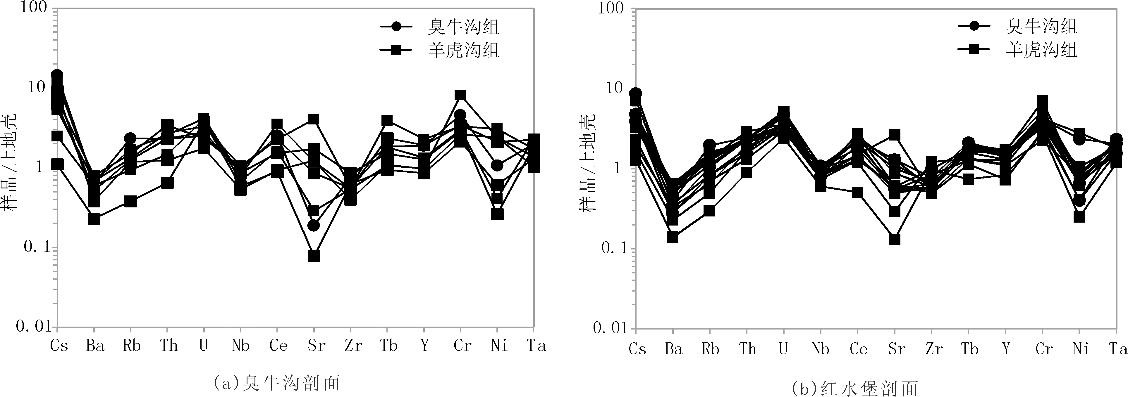
图4 武威盆地碎屑岩微量元素上地壳标准化蛛网图(上地壳标准化数据引自TAYLOR和MCLENNAN)
Fig.4 Primitive upper crust-normalized spider diagrams of clastic rocks in Wuwei Basin

图5 武威盆地碎屑岩稀土元素球粒陨石标准化分配模式图(球粒陨石标准化数据引自TAYLOR和MCLENNAN)
Fig.5 The REE distribution patterns of clastic rocks in Wuwei Basin

图6 武威盆地石炭系碎屑岩物源性质判别图((a)据ALLEGRE修改,(b)据FLOYD和LEVERIDGE修改)
Fig.6 Discrimination diagrams for provenance attribute of Carboniferous clastic rocks in Wuwei Basin
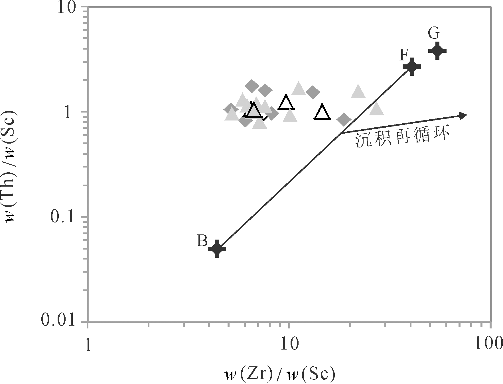
图7 武威盆地石炭系碎屑岩源岩性质判别图 据MCLENNAN等修改,图例同图5,B.玄武岩;F.长英质岩石;G.花岗岩
Fig.7 Discrimination diagram for provenance attribute of Carboniferous clastic rocks in Wuwei Basin

图8 武威盆地石炭系碎屑岩构造稳定性判别图(图例同图6)
Fig.8 Discrimination diagram for tectonic stability of Carboniferous clastic rocks in Wuwei Basin

图9 武威盆地石炭系碎屑岩构造背景判别图 图例同图6,(a)据ROSER等修改,(b)和(c)据BHATIA和CROOK修改.构造背景:CIA.大陆岛弧;OIA.大洋岛弧;ACM.活动大陆边缘;PM.被动大陆边缘
Fig.9 Discrimination diagrams for tectonic setting of Carboniferous clastic rocks in Wuwei Basin
| [1] | 佟再三. 北祁连东段石炭纪岩相古地理研究现状[J]. 兰州大学学报(自然科学版), 1992, 28(4):167-168. |
| [2] | 佟再三. 北祁连东段石炭纪古地理与构造关系初探[J]. 甘肃地质学报, 1993, 2(2):61-66. |
| [3] | 佟再三, 李汉业. 北祁连东段石炭纪岩相古地理基本特征[J]. 沉积学报, 1994, 12(1):89-97. |
| [4] | 李儒峰, 柳广弟, 马国富, 等. 武威盆地石炭系层序地层学研究[J]. 现代地质, 2010, 24(6):1048-1056. |
| [5] |
赵应成. 贺西地区盆地构造特征与油气分布[J]. 石油学报, 1999, 20(5):13-19.
DOI |
| [6] | 阎存凤, 袁剑英. 武威盆地石炭系沉积环境及含油气远景[J]. 天然气地球科学, 2011, 22(2):267-274. |
| [7] | 玉门油田石油地质志编写组. 中国石油地质志(卷十三)[M]. 北京: 石油工业出版社, 1985:10-100. |
| [8] | TAYLOR S R, MCLENNAN S M. The Continental Crust:Its Composition and Evolution[M]. Oxford: Blackwell Scientific Publications, 1985:1-90. |
| [9] | MCLENNAN S M. Rare earth element in sedimentary rock:Influence of provenance and sedimentary processes[J]. Reviews in Mineralogy, 1989, 21:169-200. |
| [10] |
MCLENNAN S M, TAYLOR S R. Sedimentary rocks and crustal evolution:Tectonic setting and secular trends[J]. The Journal of Geology, 1991, 99(1):1-21.
DOI URL |
| [11] |
MCLENNAN S M. Weathering and global denudation[J]. The Journal of Geology, 1993, 101(2):295-303.
DOI URL |
| [12] |
MCLENNAN S M, HEMMING S R, TAYLOR S R, et al. Early Proterozoic crustal evolution:Geochemical and Nd-Pb isotopic evidence from metasedimentary rocks,southwestern North America[J]. Geochimica et Cosmochimica Acta, 1995, 59(6):1153-1177.
DOI URL |
| [13] | ROLLING H R. Using Geochemical Date:Evaluation,Presentation,Interpretation[M]. London: Longman Scientific,Technical Press, 1993:1-352. |
| [14] |
FRALICK P W, KRONBERG B I. Geochemical discrimination of clastic sedimentary rock sources[J]. Sedimentary Geology, 1997, 113:111-24.
DOI URL |
| [15] |
NESBITT H W, YOUNG G M. Early Proterozoic climates and plate motions inferred from major element chemistry of lutites[J]. Nature, 1982, 299:715-717.
DOI |
| [16] |
COX R, LOWE D R, CULLERS R L. The influence of sediment recycling and basement composition on evolution of mudrock chemistry in the southwestern United States[J]. Geochimica et Cosmochimica Acta, 1995, 59(14):2919-2940.
DOI URL |
| [17] | 王国茹, 陈洪德, 朱志军, 等. 川东南-湘西地区志留系小河坝组砂岩稀土元素特征及其地质意义[J]. 石油实验地质, 2010, 32(5):487-495. |
| [18] |
ALLEGRE C T. Quantitative models of trace planet[J]. Earth Planet Science Letter, 1978, 38(1):1-25.
DOI URL |
| [19] |
FLOYD P A, LEVERIDGE B E. Tectonic environment of Devonia Gramscatho basin,south Cornwall: Framework mode and geochemical evidence from turbidite sandstones[J]. Journal of Geological Society, 1987, 144:531-542.
DOI URL |
| [20] |
ROSER B P, KORSCH R J. Determination of tectonic setting of sandstone-mudstone suites using SiO2 content and K2O/Na2O ratio[J]. The Journal of Geology, 1986, 94(5):635-650.
DOI URL |
| [21] |
ROSER B P, KORSCH R J. Provenance signatures of sandstone-mudstone suites determined using discriminant function analysis of major-element data[J]. Chemical Geology, 1988, 67(1/2):119-139.
DOI URL |
| [22] |
ROSER B P, KORSCH R J. Geochemical characterization,evolution and source of a Mesozoic accretionary wedge:The Torlesse terrane,New Zealand[J]. Geological Magazine, 1999, 136(5):493-512.
DOI URL |
| [23] |
BJATIA M R. Plate tectonics and geochemical composition of sandstones[J]. The Journal of Geology, 1983, 91:611-627.
DOI URL |
| [24] |
BHATIA M R. Rare earth element geochemistry of Australian Paleozoic graywackes and mudrocks:Provenance and tectonic control[J]. Sedimentary Geology, 1985, 45:97-133.
DOI URL |
| [25] |
BHATIA M R, CROOK K W. Trace element characteristics of gray-wackes and tectonic setting discrimination of sedimentary basin[J]. Contributions to Mineralogy and Petrology, 1986, 92:181-193.
DOI URL |
| [26] |
MURPHY J B. Tectonic influence on sedimentation along the southern flank of the late Paleozoic Magdalen basin in the Canadian Appalachians:Geochemical and isotopic constrain on the Horton Group in the St.Marys basin,Nova Scotia[J]. Geological Society of American Bulletin, 2000, 112:997-1011.
DOI URL |
| [27] |
CULLERS R L. The controls on the major-and trace-element evolution of shales,siltstones and sandstones of Ordorvician to Tertiary age in the Wet Mountains region,Colorado,U.S.A[J]. Chemical Geology, 1995, 123:107-131.
DOI URL |
| [28] |
CULLERS R L. The geochemistry of shales,siltstones and sandstones of Pennsylvanian-permian age,Colorado,USA:Implications for provenance and metamorphic studies[J]. Lithos, 2000, 51(3):181-203.
DOI URL |
| [29] | 朱弟成, 廖忠礼, 潘桂棠, 等. 正确使用构造判别图解和地球化学数据的一些建议[J]. 地质地球化学, 2001, 29(3):152-157. |
| [30] | 李双应, 李任伟, 岳书仓, 等. 安徽肥西中生代碎屑岩地球化学特征及其对物源制约[J]. 岩石学报, 2004, 20:667-676. |
| [31] | 童雪飞, 康志宏, 周磊, 等. 塔里木西北缘乌什南上石炭统索格当他乌组微量稀土元素特征及地质意义[J]. 现代地质, 2016, 30(2):426-435. |
| [32] | 谢其锋, 周立发, 蔡元峰, 等. 南祁连盆地二叠系海相烃源岩地球化学特征及其对物源属性和古环境的约束[J]. 地质学报, 2015, 89(7):1289-1301. |
| [33] |
闫义, 林舸, 王岳军, 等. 盆地陆源碎屑沉积物对源区构造背景的指示意义[J]. 地球科学进展, 2002, 17(1):85-90.
DOI |
| [34] | 闫臻, 肖文交, 刘传周, 等. 祁连山老君山砾岩的碎屑组成和源区大地构造背景[J]. 地质通报, 2006, 25(1/2):83-98. |
| [35] | 张金亮, 张鑫. 塔中地区志留系砂岩元素地球化学特征与物源判别意义[J]. 岩石学报, 2007, 23:2990-3002. |
| [36] | 王若谷, 李文厚, 廖友运, 等. 鄂尔多斯盆地三叠系延长组长7段物源区分析[J]. 地质通报, 2013, 32(4):671-684. |
| [37] | 阎存凤, 袁剑英. 北祁连东部石炭纪岩相古地理[J]. 沉积学报, 2008, 26(2):193-201. |
| [38] |
DOSTAL J, KEPPIE J D. Geochemistry of low-grade clastic rocks in the Actalán Complex of southern Mexico:Evidence for local provenance in felsic-intermediate igneous rocks[J]. Sedimentary Geology, 2009, 222(3/4):241-253.
DOI URL |
| [39] |
LAMBECK A, HUSTON D, MAIDMENT D, et al. Sedimentary geochemistry,geochronology and sequence stratigraphy as tools to typecast stratigraphic units and constrain basin evolution in the gold mineralized Palaeoproterozoic Tanami Region, Northern Australia[J]. Precambrian Research, 2008, 166:185-203.
DOI URL |
| [40] | RASHID S A. The geochemistry of Mesoproterozoic clastic sedimentary rocks from the Rautgara Formation,Kumaun Lesser Himalaya:Implications for provenance,mineralogical control and weathering[J]. Current Science, 2005, 88(11):1832-1836. |
| [41] |
WRONKIEWICZ D J, CONDIE K C. Geochemistry of Archean shales from the Witwatersrand Supergroup,South Africa:Source-area weathering and provenance[J]. Geochemica et Cosmochimica Acta, 1987, 51:2401-2416.
DOI URL |
| [1] | 何云龙, 张国宾, 杨言辰, 冯玥, 孔金贵, 陈兴凯. 锡霍特—阿林造山带那丹哈达地体四平山金矿床成因与构造背景:锆石U-Pb年代学、岩石和流体地球化学制约[J]. 现代地质, 2024, 38(01): 128-153. |
| [2] | 陈曦, 肖玲, 王明瑜, 郝晨曦, 王峰, 唐红南. 鄂尔多斯盆地西南缘长8油层组物源与古沉积环境恢复:来自岩石地球化学的证据[J]. 现代地质, 2023, 37(05): 1264-1281. |
| [3] | 杜贯新, 闫百泉, 孙雨, 钱程, 秦涛, 臧延庆. 松嫩平原黑土区西北部阿荣旗地下黑土稀土元素特征及环境指示[J]. 现代地质, 2023, 37(03): 813-820. |
| [4] | 曹玉璐, 曾宇轲, 张元元. 基于扫描电子显微镜的重矿物物源分析方法对比[J]. 现代地质, 2023, 37(02): 475-485. |
| [5] | 邵龙飞, 于福生, 王丹丹, 李超. 准噶尔盆地西北缘中拐凸起石炭纪安山岩年代学、地球化学特征及其构造意义[J]. 现代地质, 2022, 36(03): 812-823. |
| [6] | 白翔宇, 马郡伟, 夏清萍, 谭先锋, 李开开. 北京西山下苇甸第三统/芙蓉统界线附近碳酸盐岩地球化学特征及古环境意义[J]. 现代地质, 2022, 36(02): 729-741. |
| [7] | 远继东, 姜正龙, 代友旭, 郝连成, 张健康, 张德程, 郑立龙. 湛江湾海域表层沉积物稀土元素特征及其物源指示意义[J]. 现代地质, 2022, 36(01): 77-87. |
| [8] | 严镜, 刘景显, 蒲万峰, 魏学平, 李智斌. 西秦岭中—晚三叠世构造属性:来自将其那梁侵入杂岩体的年代学及地球化学证据[J]. 现代地质, 2021, 35(06): 1677-1690. |
| [9] | 吴龙, 柳长峰, 刘文灿, 张宏远. 青藏高原东北缘祁连山三叠系砂岩碎屑锆石U-Pb定年及其物源分析[J]. 现代地质, 2021, 35(05): 1178-1193. |
| [10] | 黄清华, 席党鹏, 王辉, 张文婧, 王建伟, 曹维福, 贾卧, 王丽静. 松辽盆地北部中二叠统碳酸盐岩元素和稳定同位素地球化学特征与古环境[J]. 现代地质, 2021, 35(05): 1282-1295. |
| [11] | 黎介, 刘宁强, 龚庆杰, 吴轩, 严桃桃. 基于微量元素岩性地球化学基因的构建与检验[J]. 现代地质, 2021, 35(05): 1459-1470. |
| [12] | 赵保具, 颜开, 肖荣阁. 一种稀土参数图解新方法:以内蒙古拜仁达坝-维拉斯托闪长岩成因研究为例[J]. 现代地质, 2021, 35(03): 608-624. |
| [13] | 杨硕, 刘阁, 靳刘圆, 郑海峰. 东准噶尔卡拉麦里松喀尔苏岩体花岗岩年代学、地球化学特征及其构造意义[J]. 现代地质, 2021, 35(02): 492-503. |
| [14] | 张海华, 李晓海, 张健, 郑月娟, 陈树旺, 张德军, 苏飞, 卞雄飞, 孙雷. 松辽盆地北部上二叠统林西组古生物年代学、地球化学特征及地质意义[J]. 现代地质, 2021, 35(02): 568-578. |
| [15] | 胡妍, 胡永兴, 张翔, 杨涛, 欧扬剑. 鄂尔多斯盆地西南缘镇原地区砂岩型铀矿元素地球化学特征及地质意义[J]. 现代地质, 2020, 34(06): 1153-1165. |
| 阅读次数 | ||||||
|
全文 |
|
|||||
|
摘要 |
|
|||||