

现代地质 ›› 2024, Vol. 38 ›› Issue (03): 793-806.DOI: 10.19657/j.geoscience.1000-8527.2024.001
王金雨1,2( ), 刘永顺2(), 潘美慧1(), 聂保锋2, 邹望2, 路智2, 张心怡2
出版日期:2024-06-10
发布日期:2024-07-04
通讯作者:
刘永顺,男,博士,副教授,1966年出生,主要从事火山学、岩石学、地质流体力学和地质系统复杂性科学研究。Email: cnu901@126.com。潘美慧,女,博士,副教授,1983年出生,主要从事第四纪环境变化方面研究。Email: panmh@nwnu.edu.cn。
作者简介:王金雨,女,硕士研究生,1998年出生,主要从事火山系统与资源环境效应研究。Email:wangjinyu8587@163.com。
基金资助:
WANG Jinyu1,2(), LIU Yongshun2(), PAN Meihui1(), NIE Baofeng2, ZOU Wang2, LU Zhi2, ZHANG Xinyi2
Online:2024-06-10
Published:2024-07-04
摘要:
火山地貌及其成因研究对深入揭示火山形成与行星表面形态演化具有重要意义。本文基于黑龙江五大连池火山区的遥感影像和数字高程模型(DEM)数据,对火山群形貌进行综合解译和地貌分形分析,从系统科学角度讨论形成本区火山地貌系统的复杂成因机制。研究结果表明:(1)火山锥和熔岩地貌构成了区内低起伏频率的地表形态,断裂带上复合型火山锥的分布数量影响该方向上的地形复杂度。(2)火山群地貌分形具有多度域分形结构且分形维数较小(D≈2),推测是受到大面积熔岩地貌和低矮火山锥影响造成的。沿断裂构造方向的地形剖面分形维数显示,五大连池地区三组断裂方向的地貌各向异性较小(D值为1.142~1.275,Dmax与Dmin仅相差0.133),NE方向的分形维数较大(DNE为1.223~1.275),是影响火山群地貌形成的主要断裂方向。(3)火山群地貌特征受到内外营力协同控制,深浅两套断裂构造和岩浆系统是影响现阶段火山区形貌的主要因素。外营力在中微观尺度随机粗化作用正在加强,但在宏观尺度上尚未占协同对抗上风,区域形态还未发生改变。遥感波谱特性与地貌形态分析对火山地貌研究是有效的,地貌分形分析可以量化不同尺度下的地貌形态特征,这为火山区地貌及其成因机制研究提供了新的思路和方法。
中图分类号:
王金雨, 刘永顺, 潘美慧, 聂保锋, 邹望, 路智, 张心怡. 黑龙江五大连池火山群的地貌形态和分形特征及其成因[J]. 现代地质, 2024, 38(03): 793-806.
WANG Jinyu, LIU Yongshun, PAN Meihui, NIE Baofeng, ZOU Wang, LU Zhi, ZHANG Xinyi. Topography and Fractal Characteristics and Their Genesis of the Wudalianchi Volcanic Group in Heilongjiang[J]. Geoscience, 2024, 38(03): 793-806.

图1 五大连池火山群区域地质图 (a)东北地区断裂分布与五大连池火山群的位置(底图据文献[42]);(b)五大连池火山区地质简图(底图据文献[45]);1.火山喷发带和编号;2.断裂带和编号;3.嫩江局部隆起;4.东北地区火山分布区:① 科洛—五大连池—二克山火山喷发带;② 小兴安岭火山喷发带;③ 依舒火山喷发带;④ 敦密火山喷发带;⑤ 东宁火山喷发带;F1.嫩江深断裂;F2.孙吴—大庆深断裂;F3.依舒深断裂;F4.多宝山—铁力—林口深断裂;F5.讷谟尔河深断裂;F6.小兴安岭西南缘深断裂
Fig.1 Regional geological map of the Wudalianchi Volcanic Group
| 编号 | 波段类型 | 波长范围 (μm) | 空间分辨率 (m) |
|---|---|---|---|
| b1 | Coastal | 0.43~0.45 | 30 |
| b2 | Blue | 0.45~0.51 | 30 |
| b3 | Green | 0.53~0.59 | 30 |
| b4 | Red | 0.64~0.67 | 30 |
| b5 | NIR | 0.85~0.88 | 30 |
| b6 | SWIR1 | 1.57~1.65 | 30 |
| b7 | SWIR2 | 2.11~2.29 | 30 |
| b8 | PAN | 0.50~0.68 | 15 |
| b9 | Cirrus | 1.36~1.38 | 30 |
| b10 | TIR1 | 10.60~11.19 | 100 |
| b11 | TIR2 | 11.50~12.51 | 100 |
表1 Landsat 8波段与空间分辨率
Table 1 Landsat 8 bands and spatial resolutions
| 编号 | 波段类型 | 波长范围 (μm) | 空间分辨率 (m) |
|---|---|---|---|
| b1 | Coastal | 0.43~0.45 | 30 |
| b2 | Blue | 0.45~0.51 | 30 |
| b3 | Green | 0.53~0.59 | 30 |
| b4 | Red | 0.64~0.67 | 30 |
| b5 | NIR | 0.85~0.88 | 30 |
| b6 | SWIR1 | 1.57~1.65 | 30 |
| b7 | SWIR2 | 2.11~2.29 | 30 |
| b8 | PAN | 0.50~0.68 | 15 |
| b9 | Cirrus | 1.36~1.38 | 30 |
| b10 | TIR1 | 10.60~11.19 | 100 |
| b11 | TIR2 | 11.50~12.51 | 100 |

图2 五大连池火山区伪彩色遥感影像解译图 (a)b11、b5和b7波段伪彩色影像;(b)b5/b4、b6/b5和b7/b8波段伪彩色影像
Fig.2 Interpretation map of the pseudo-color image of the Wudalianchi volcanic area
| 火山地貌类型 | 解译标志 | 实例 | ||
|---|---|---|---|---|
| 火山锥 (I) | 单锥型 火山锥 | 马蹄型火山锥 | 锥体不完整,火山口不闭合;具有1个清晰朝向的U形熔岩溢出口 | 北格拉球山、东焦得布山、西焦得布山、药泉山、小孤山、东龙门山、尾山 |
| 多瓣型火山锥 | 锥体完整性差,熔岩流将锥体切割成多瓣;具有2个及以上熔岩溢出口 | 火烧山、笔架山 | ||
| 较完整火山锥 | 锥体无明显破坏,呈近圆形或椭圆状,具有1个圆形闭合火山口,1个熔岩溢出口。南格拉球山火山口积水形成近圆形火山口湖 | 南格拉球山 | ||
| 复合型火山锥 | 锥体数量多为2个及以上;具有多个熔岩溢出口 | 卧虎山、老黑山、莫拉布山、西龙门山(单锥) | ||
| 熔岩流 (II) | 结壳熔岩类 | 主要见于新期熔岩台地;在b5/b4、b6/b5和b7/b6伪彩色影像中为深蓝色区域 | 老黑山、火烧山结壳熔岩流 | |
| 渣状熔岩类 | 主要见于新期熔岩台地;在b5/b4、b6/b5和b7/b6伪彩色影像中为紫色区域 | 老黑山、火烧山渣状熔岩流 | ||
| 块状熔岩类 | 分布广泛,展布于熔岩流中段或尾部,几乎不与前两类熔岩分布区重叠;多呈面状或条带状,边界不规则。在真彩色影像中呈现墨绿色;b11、b5和b7伪彩色影像中呈现棕红色 | 莫拉布山、西龙门山块状熔岩流 | ||
| 熔岩台地(III) | 呈面状展布;上覆多期碱性玄武岩熔岩流,局部有水波纹状、斑点状异色图案,为熔岩流冷却形成的痕迹,台地表面多被农田或河流沉积物覆盖。火山岩在真彩色影像中呈现棕黄色;b11、b5和b7伪彩色影像中火山岩呈绿色,台地边缘全新世河流沉积物呈荧光绿色 | |||
| 火山堰塞湖(IV) | 被老黑山、火烧山、东西龙门山、东西焦得布山、尾山所在熔岩台地围限,呈串珠状分布。在真彩色影像中呈现黑绿色;b11、b5和b7伪彩色影像中呈黑色 | 头池至五池水体 | ||
| 推断断裂构造 | 发育的火山锥呈线性排布,NE向2条、NW向4条和W—E向1条,总体构成呈网格状 | 详见解译 | ||
| 其他 地物 | 燕山期黑云母花岗岩 | 主要出露于新期火山熔岩台地附近与五池北侧;在b5/b4、b6/b5和b7/b6伪彩色影像中呈现橘红色 | ||
| 第四纪农田 | 熔岩台地四周低平宽阔、经风化和人为开垦形成的农田。遥感影像见平行纹理,在真彩色影像中表现为暗灰及白条相间的格状;b11、b5和b7伪彩色影像中呈紫色或粉色格状 | |||
表2 五大连池地区火山地貌综合解译标志
Table 2 Comprehensive interpretation characteristics of volcanic landforms in the Wudalianchi area
| 火山地貌类型 | 解译标志 | 实例 | ||
|---|---|---|---|---|
| 火山锥 (I) | 单锥型 火山锥 | 马蹄型火山锥 | 锥体不完整,火山口不闭合;具有1个清晰朝向的U形熔岩溢出口 | 北格拉球山、东焦得布山、西焦得布山、药泉山、小孤山、东龙门山、尾山 |
| 多瓣型火山锥 | 锥体完整性差,熔岩流将锥体切割成多瓣;具有2个及以上熔岩溢出口 | 火烧山、笔架山 | ||
| 较完整火山锥 | 锥体无明显破坏,呈近圆形或椭圆状,具有1个圆形闭合火山口,1个熔岩溢出口。南格拉球山火山口积水形成近圆形火山口湖 | 南格拉球山 | ||
| 复合型火山锥 | 锥体数量多为2个及以上;具有多个熔岩溢出口 | 卧虎山、老黑山、莫拉布山、西龙门山(单锥) | ||
| 熔岩流 (II) | 结壳熔岩类 | 主要见于新期熔岩台地;在b5/b4、b6/b5和b7/b6伪彩色影像中为深蓝色区域 | 老黑山、火烧山结壳熔岩流 | |
| 渣状熔岩类 | 主要见于新期熔岩台地;在b5/b4、b6/b5和b7/b6伪彩色影像中为紫色区域 | 老黑山、火烧山渣状熔岩流 | ||
| 块状熔岩类 | 分布广泛,展布于熔岩流中段或尾部,几乎不与前两类熔岩分布区重叠;多呈面状或条带状,边界不规则。在真彩色影像中呈现墨绿色;b11、b5和b7伪彩色影像中呈现棕红色 | 莫拉布山、西龙门山块状熔岩流 | ||
| 熔岩台地(III) | 呈面状展布;上覆多期碱性玄武岩熔岩流,局部有水波纹状、斑点状异色图案,为熔岩流冷却形成的痕迹,台地表面多被农田或河流沉积物覆盖。火山岩在真彩色影像中呈现棕黄色;b11、b5和b7伪彩色影像中火山岩呈绿色,台地边缘全新世河流沉积物呈荧光绿色 | |||
| 火山堰塞湖(IV) | 被老黑山、火烧山、东西龙门山、东西焦得布山、尾山所在熔岩台地围限,呈串珠状分布。在真彩色影像中呈现黑绿色;b11、b5和b7伪彩色影像中呈黑色 | 头池至五池水体 | ||
| 推断断裂构造 | 发育的火山锥呈线性排布,NE向2条、NW向4条和W—E向1条,总体构成呈网格状 | 详见解译 | ||
| 其他 地物 | 燕山期黑云母花岗岩 | 主要出露于新期火山熔岩台地附近与五池北侧;在b5/b4、b6/b5和b7/b6伪彩色影像中呈现橘红色 | ||
| 第四纪农田 | 熔岩台地四周低平宽阔、经风化和人为开垦形成的农田。遥感影像见平行纹理,在真彩色影像中表现为暗灰及白条相间的格状;b11、b5和b7伪彩色影像中呈紫色或粉色格状 | |||

图3 五大连池火山区地貌平面遥感解译图
Fig.3 Interpretation map of plane remote sensing of the topography in the Wudalianchi volcanic area
| 火山(名称缩写) | 锥体数/ 火山口数 | 溢出口 数量 | 溢出口方位 | 锥体类型 |
|---|---|---|---|---|
| 尾山(WS) | 1/1 | 1 | 北西侧 | 马蹄型 |
| 小孤山(XGS) | 1/1 | 1 | 北东侧 | 马蹄型 |
| 药泉山(YQS) | 1/1 | 1 | 南西侧 | 马蹄型 |
| 东龙门山(DLMS) | 1/1 | 1 | 东南侧 | 马蹄型 |
| 东焦得布山(DJDBS) | 1/1 | 1 | 正南侧 | 马蹄型 |
| 西焦得布山(XJDBS) | 1/1 | 1 | 东南侧 | 马蹄型 |
| 北格拉球山(BGLQS) | 1/1 | 1 | 正西侧 | 马蹄型 |
| 火烧山(HSS) | 1/1 | 2 | 正南侧、北西侧 | 多瓣型(两瓣山) |
| 笔架山(BJS) | 1/1 | 3 | 西侧、东南侧、北东侧 | 多瓣型(三瓣山) |
| 南格拉球山(NGLQS) | 1/1 | 1 | 北侧(缺口不明显) | 较完整锥 |
| 老黑山(LHS) | 2/3 | 5 | 东西两侧各1处、北侧2处、南侧1处 | 复合型 |
| 西龙门山(XLMS) | 1/2 | 3 | 正东侧、西南侧小缺口各1处、 东南侧半月形大缺口1处 | 复合型(单锥) |
| 莫拉布山(MLBS) | 2/2 | 2 | 东锥正北侧,西锥西北侧(被破坏,不明显) | 复合型 |
| 卧虎山(WHS) | 4/4 | 4 | 4个锥体各1处熔岩溢出口,分别位于: 北锥北侧、东锥东侧、西锥西侧、南锥北西侧 | 复合型 |
表3 五大连池火山锥的分类
Table 3 Classification of the Wudalianchi volcanic cones
| 火山(名称缩写) | 锥体数/ 火山口数 | 溢出口 数量 | 溢出口方位 | 锥体类型 |
|---|---|---|---|---|
| 尾山(WS) | 1/1 | 1 | 北西侧 | 马蹄型 |
| 小孤山(XGS) | 1/1 | 1 | 北东侧 | 马蹄型 |
| 药泉山(YQS) | 1/1 | 1 | 南西侧 | 马蹄型 |
| 东龙门山(DLMS) | 1/1 | 1 | 东南侧 | 马蹄型 |
| 东焦得布山(DJDBS) | 1/1 | 1 | 正南侧 | 马蹄型 |
| 西焦得布山(XJDBS) | 1/1 | 1 | 东南侧 | 马蹄型 |
| 北格拉球山(BGLQS) | 1/1 | 1 | 正西侧 | 马蹄型 |
| 火烧山(HSS) | 1/1 | 2 | 正南侧、北西侧 | 多瓣型(两瓣山) |
| 笔架山(BJS) | 1/1 | 3 | 西侧、东南侧、北东侧 | 多瓣型(三瓣山) |
| 南格拉球山(NGLQS) | 1/1 | 1 | 北侧(缺口不明显) | 较完整锥 |
| 老黑山(LHS) | 2/3 | 5 | 东西两侧各1处、北侧2处、南侧1处 | 复合型 |
| 西龙门山(XLMS) | 1/2 | 3 | 正东侧、西南侧小缺口各1处、 东南侧半月形大缺口1处 | 复合型(单锥) |
| 莫拉布山(MLBS) | 2/2 | 2 | 东锥正北侧,西锥西北侧(被破坏,不明显) | 复合型 |
| 卧虎山(WHS) | 4/4 | 4 | 4个锥体各1处熔岩溢出口,分别位于: 北锥北侧、东锥东侧、西锥西侧、南锥北西侧 | 复合型 |

图4 五大连池火山区地形与推断断裂分布图
Fig.4 Topography and deduced fault distribution of the Wudalianchi volcanic area
| 断裂方向 | 数量 | 排布的火山 | 编号 |
|---|---|---|---|
| NE向近 平行断裂 | 3 | WHS—BJS—LHS—HSS | LineNE-1 |
| XJDBS—XLMS—MLBS | LineNE-2 | ||
| NGLQS—BGLQS | |||
| NW向近 平行断裂 | 4 | XGS—XLMS—WS | LineNW-1 |
| DJDBS—HSS | |||
| XJDBS—LHS | LineNW-2 | ||
| YQS—BJS—BGLQS | LineNW-3 | ||
| W—E向断裂 | 1 | WHS—YQS—DJDBS | LineW—E |
表4 主要断裂信息
Table 4 Information of the main faults
| 断裂方向 | 数量 | 排布的火山 | 编号 |
|---|---|---|---|
| NE向近 平行断裂 | 3 | WHS—BJS—LHS—HSS | LineNE-1 |
| XJDBS—XLMS—MLBS | LineNE-2 | ||
| NGLQS—BGLQS | |||
| NW向近 平行断裂 | 4 | XGS—XLMS—WS | LineNW-1 |
| DJDBS—HSS | |||
| XJDBS—LHS | LineNW-2 | ||
| YQS—BJS—BGLQS | LineNW-3 | ||
| W—E向断裂 | 1 | WHS—YQS—DJDBS | LineW—E |

图5 沿断裂方向的地形剖面分析图(WS等火山名称缩写见表3)
Fig.5 Diagrams of topographical analysis along the fracture directions (seeing Table 3 for the abbreviations of volcano names such as WS)
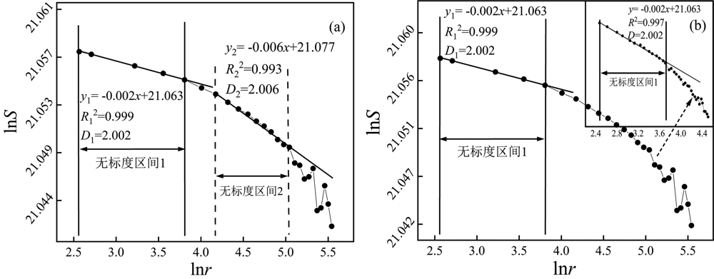
图6 五大连池火山群地表分形线性拟合
Fig.6 Linear fitting of the surface fractal dimensions in Wudalianchi Volcanic Group
| 剖面编号 | 回归方程 | 分形维数 D值 | 相关性系数 R2 |
|---|---|---|---|
| LineNW-1 | y=-1.183x+0.406 | 1.183 | 0.993 |
| LineNW-2 | y=-1.183x+0.426 | 1.183 | 0.992 |
| LineNW-3 | y=-1.142x+0.402 | 1.142 | 0.993 |
| LineNE-1 | y=-1.275x+0.436 | 1.275 | 0.992 |
| LineNE-2 | y=-1.223x+0.403 | 1.223 | 0.993 |
| LineW—E | y=-1.174x+0.347 | 1.174 | 0.995 |
表5 五大连池火山区地貌特征分形维数计算结果
Table 5 Calculation results of the fractal dimensions of topographic features in the Wudalianchi volcanic area
| 剖面编号 | 回归方程 | 分形维数 D值 | 相关性系数 R2 |
|---|---|---|---|
| LineNW-1 | y=-1.183x+0.406 | 1.183 | 0.993 |
| LineNW-2 | y=-1.183x+0.426 | 1.183 | 0.992 |
| LineNW-3 | y=-1.142x+0.402 | 1.142 | 0.993 |
| LineNE-1 | y=-1.275x+0.436 | 1.275 | 0.992 |
| LineNE-2 | y=-1.223x+0.403 | 1.223 | 0.993 |
| LineW—E | y=-1.174x+0.347 | 1.174 | 0.995 |

图7 五大连池火山群三组断裂方向上的分形维数对比图
Fig.7 Comparison of fractal dimensions of the three fault directions in Wudalianchi Volcanic Group
| [1] | THOURET J C. Volcanic geomorphology—an overview[J]. Earth-science Reviews, 1999, 47(1/2): 95-131. |
| [2] | RAMÍREZ-URIBE I, SIEBE C, CHEVREL M O, et al. Rancho Seco monogenetic volcano (Michoacán, Mexico): Petrogenesis and lava flow emplacement based on LiDAR images[J]. Journal of Volcanology and Geothermal Research, 2021, 411:107169. |
| [3] | REVENAUGH J, SIPKIN S A. Mantle discontinuity structure beneath China[J]. Journal of Geophysical Research: Solid Earth, 1994, 99: 21911-21927. |
| [4] | LIU J Q, HAN J T, FYFE W S. Cenozoic episodic volcanism and continental rifting in Northeast China and possible link to Japan Sea development as revealed from K-Ar geochronology[J]. Tectonophysics, 2001, 339(3): 385-401. |
| [5] | 巩杰生. 论五大连池申报世界自然遗产[J]. 黑龙江地质, 2001, 12(4): 65-70. |
| [6] | 巩杰生. 五大连池火山的构造环境, 时代和类型[J]. 黑龙江地质, 1997, 8(4): 19-28. |
| [7] | 吕宗文. 黑龙江五大连池火山群现代火山构造及其形成机制[J]. 火山地质与矿产, 1994, 15(1): 5-21. |
| [8] | 吕宗文. 五大连池火山群的构造环境与喷发机理[J]. 东北地震研究, 1996, 12(1): 25-30. |
| [9] | 李永生, 刘永顺, 张招崇, 等. 五大连池老黑山火山弹和喷发柱动力学模拟[J]. 现代地质, 2012, 26(2): 220-228. |
| [10] | 邱家骧, 吴志勤, 杜向荣. 黑龙江省二克山—五大连池—科洛富钾火山岩中幔源包体的研究[J]. 现代地质, 1987, 1(增): 344-356. |
| [11] | 邵济安, 张文兰. 演化中的裂谷带: 五大连池火山岩带[J]. 地学前缘, 2008, 15(6): 241-250. |
| [12] | 彭年, 崔莹, 刘永顺, 等. 五大连池老黑山火山钾质玄武岩结晶动力学研究[J]. 岩石学报, 2020, 36(7): 2035-2046. |
| [13] |
MENG F C, TIAN Y L, ZHOU Y Q, et al. Cenozoic potassic volcanic rocks from the Keluo and Wudalianchi volcanic districts, Northeast China: Origin from the new sub-continental lithospheric mantle (SCLM) metasomatized by potassium-rich fluids from delaminated lower crust[J]. Frontiers of Earth Science, 2022, 16(4): 989-1004.
DOI |
| [14] | WEI W, HAMMOND J O S, ZHAO D P, et al. Seismic evidence for a mantle transition zone origin of the Wudalianchi and halaha volcanoes in Northeast China[J]. Geochemistry, Geophysics, Geosystems, 2019, 20(1): 398-416. |
| [15] | GAO J, ZHANG H J, ZHANG S Q, et al. Magma recharging beneath the Weishan volcano of the intraplate Wudalianchi volcanic field, Northeast China, implied from 3-D magnetotelluric imaging[J]. Geology, 2020, 48(9): 913-918. |
| [16] | 王承祺, 杜向荣, 刘继贤. 科洛—五大连池—二克山火山群结束语[J]. 华东地质学院学报, 1987, 10(2): 258-261. |
| [17] | 白志达, 孙善平, 李家振, 等. 五大连池新期火山锥体结构及喷发过程[J]. 地质论评, 1999, 45(增): 369-377. |
| [18] | 毛翔, 李江海, 高危言, 等. 黑龙江五大连池火山群火山分布与断裂关系新认识[J]. 高校地质学报, 2010, 16(2): 226-235. |
| [19] | FU H, FU B H, NINOMIYA Y, et al. New insights of geomorphologic and lithologic features on Wudalianchi volcanoes in the northeastern China from the ASTER multispectral data[J]. Remote Sensing, 2019, 11(22): 2663. |
| [20] | ZHAO Y W, LI N, FAN Q C, et al. Two episodes of volcanism in the Wudalianchi volcanic belt, NE China: Evidence for tectonic controls on volcanic activities[J]. Journal of Volcanology and Geothermal Research, 2014, 285: 170-179. |
| [21] | CHEN Z Q, ZHAO Y W, BAI X, et al. Wudalianchi volcanic field, NE China: Tectonic setting, eruptive history, and geophysical insights[J]. Geological Society, London, Special Publications, 2021, 510(1): 61-80. |
| [22] | 单新建, 叶洪, 陈国光. 利用ERS-2 SAR图像纹理分析方法揭示长白山天池火山近代喷发物空间分布特征[J]. 第四纪研究, 2002, 22(2): 123-130. |
| [23] | FERRARIS F, FIRPO M, PAZZAGLIA F J. DEM analyses and morphotectonic interpretation: The Plio-Quaternary evolution of the eastern Ligurian Alps, Italy[J]. Geomorphology, 2012, 149/150: 27-40. |
| [24] |
GONG L W, LI N, FAN Q C, et al. Mapping the topography and cone morphology of the Dalinor volcanic swarm in Inner Mongolia with remote sensing and DEM data[J]. Frontiers of Earth Science, 2016, 10(3): 578-594.
DOI |
| [25] | HAAG M B, BAEZ W A, SOMMER C A, et al. Geomorphology and spatial distribution of monogenetic volcanoes in the southern Puna Plateau (NW Argentina)[J]. Geomorphology, 2019, 342: 196-209. |
| [26] | PEDRAZZI D, KERESZTURI G, LOBO A, et al. Geomorphology of the post-caldera monogenetic volcanoes at Deception Island, Antarctica-Implications for landform recognition and volcanic hazard assessment[J]. Journal of Volcanology and Geothermal Research, 2020, 402(1):106986. |
| [27] | 王丽竹, 赵勇伟, 李霓. 无人机摄影测量技术在单成因火山喷发研究中的应用:以内蒙古达里诺尔鸽子山火山为例[J]. 矿物岩石地球化学通报, 2022, 41(4): 739-746. |
| [28] | ZHANG R, KERESZTURI G, BRENNA M, et al. Sensitivity assessment of morphometric parameters of monogenetic volcanic landforms with global free DEMs[J]. Geomorphology, 2022, 415: 108408. |
| [29] | 崔晓歌, 尹京武, 徐旸, 等. 基于DEM的中国北方新生代火山锥降解过程研究[J]. 高校地质学报, 2017, 23(3): 397-407. |
| [30] | 顾亚宁. 基于遥感技术的五大连池火烧山熔岩流表壳类型及喷发过程研究[D]. 北京: 中国地震局地质研究所, 2019. |
| [31] | MANDELBROT B B. The Fractal Geometry of Nature[M]. San Francisco: W. H.Freeman, 1982. |
| [32] | 张桐, 周德全. 分形理论在地貌学的应用研究进展与展望[J]. 价值工程, 2018, 37(33): 279-283. |
| [33] | 崔灵周, 李占斌, 肖学年. 岔巴沟流域地貌形态分形特征量化研究[J]. 水土保持学报, 2004, 18(2): 41-44. |
| [34] | 龙毅, 周侗, 汤国安, 等. 典型黄土地貌类型区的地形复杂度分形研究[J]. 山地学报, 2007, 25(4): 385-392. |
| [35] | CAI J D, YOU Q. Fractal theory and its application in studying the feature of landforms[M]// 2010 International Workshop on Chaos-Fractal Theories and Applications. Kunming: IEEE, 2010: 440-444. |
| [36] | 邱海军, 曹明明, 刘闻, 等. 区域滑坡空间分布的变维分形特征研究[J]. 现代地质, 2014, 28(2): 443-448. |
| [37] | WANG X, LIU H, YAO K, et al. Study on the distribution of geological hazards based on fractal characteristics:A case study of Dachuan district[J]. The International Archives of the Photogrammetry, Remote Sensing and Spatial Information Sciences, 2018, XLII-3: 1781-1787. |
| [38] | 路芳, 高明星, 周书贤, 等. 阿尔金东段断裂带流域地貌特征及其构造活动[J]. 现代地质, 2023, 37(5): 1100-1109. |
| [39] | 毕丽思, 何宏林, 魏占玉, 等. 利用分形参数进行地貌定量分区研究: 以鄂尔多斯块体及周边为例[J]. 第四纪研究, 2011, 31(1): 137-149. |
| [40] | OUCHI S J, MATSUSHITA M. Measurement of self-affinity on surfaces as a trial application of fractal geometry to landform analysis[J]. Geomorphology, 1992, 5(1/2): 115-130. |
| [41] | 陈兵, 彭芳, 李鹏, 等. 基于DEM的流域地貌特征分形量化研究[J]. 水土保持研究, 2019, 26(4): 31-35. |
| [42] | 王先政. 五大连池钾质碱性玄武岩产出的构造环境及其意义[J]. 黑龙江地质, 1997, 8(4): 40-50. |
| [43] | 徐衍强. 五大连池第四纪火山群的喷发类型和喷发型式[J]. 黑龙江地质, 1997, 8(4): 3-11, 28. |
| [44] | 刘永顺, 李家振, 白志达, 等. 黑龙江省五大连池新期火山[M]//刘若新.中国的活火山. 北京: 地震出版社, 2000: 44-57. |
| [45] | 地质部地质博物馆. 中国五大连池火山[M]. 上海: 上海科学技术出版社, 1979: 1-83. |
| [46] | BUSTOS E, ARNOSIO M, MURCIA H, et al. Volcanic evolution through geomorphological mapping: A case study of Cerro Bravo volcano (Colombia)[J]. Journal of South American Earth Sciences, 2023, 128: 104472. |
| [47] | 白卉, 牛军平, 张红红, 等. 遥感在长白山玄武岩覆盖区基岩填图中的应用[J]. 吉林地质, 2021, 40(1): 34-38. |
| [48] | MOGREN S, SAIBI H, MUKHOPADHYAY M, et al. Analyze the spatial distribution of lava flows in Al-Ays Volcanic Area, Saudi Arabia, using remote sensing[J]. Arabian Journal of Geosciences, 2017, 10(6): 133. |
| [49] | FU H, FU B H, SHI P L, et al. International geological significance of the potential Al-Medina volcanic UNESCO Global Geo-park Project in Saudi Arabia revealed from multi-satellite remote sensing data[J]. Heritage Science, 2021, 9(1): 149. |
| [50] |
张柳毅, 李霓, 赵勇伟, 等. 腾冲火山区地形地貌特征及断裂制约关系: 卫片与DEM解译的认识[J]. 地震地质, 2012, 34(4): 755-767.
DOI |
| [51] | 钱程, 崔天日, 江斌, 等. 长白山地区晚新生代火山地貌形态研究及其地质应用[J]. 第四纪研究, 2014, 34(2): 312-324. |
| [52] | 李锰, 朱令人, 龙海英. 不同类型地貌的各向异性分形与多重分形特征研究[J]. 地球学报, 2003, 24(3): 237-242. |
| [53] | 洪顺英, 申旭辉, 荆凤, 等. 基于SRTM-DEM的阿尔泰山构造地貌特征分析[J]. 国土资源遥感, 2007, 19(3): 62-66, 108-109. |
| [54] | 李旭涛, 曹汉强, 赵鸿燕. 分形布朗运动模型及其在地形分析中的应用[J]. 华中科技大学学报(自然科学版), 2003, 31(5): 50-52. |
| [55] | ZHU J B, LIANG D N. Combinatorial fractal Brownian motion model[J]. Science in China Series E: Technological Sciences, 2000, 43(3): 254-262. |
| [56] | YOKOYA N, YAMAMOTO K, FUNAKUBO N. Fractal-based analysis and interpolation of 3D natural surface shapes and their application to terrain modeling[J]. Computer Vision, Gra-phics, and Image Processing, 1989, 46(3): 284-302. |
| [57] | KLINKENBERG B, GOODCHILD M F. The fractal properties of topography: A comparison of methods[J]. Earth Surface Processes and Landforms, 1992, 17(3): 217-234. |
| [58] | 施行觉, 许和明, 牛志仁, 等. 岩石断面的自仿射分形及其分维的计算[J]. 中国地震, 1992, 8(3): 3-8. |
| [59] | 冯志刚, 周宏伟. 图像的分形维数计算方法及其应用[J]. 江苏理工大学学报(自然科学版), 2001, 22(6): 92-95. |
| [60] | 杨书申, 邵龙义. MATLAB环境下图像分形维数的计算[J]. 中国矿业大学学报, 2006, 35(4): 478-482. |
| [61] | 高危言. 板内单成因火山地质地貌特征与形成过程: 以五大连池火山群为例[D]. 北京: 北京大学, 2012. |
| [62] | WANG Y, CHEN H Z. Tectonic controls on the Pleistocene-Holocene Wudalianchi volcanic field (northeastern China)[J]. Journal of Asian Earth Sciences, 2005, 24(4): 419-431. |
| [63] | EVANS I S. Scale-specific landforms and aspects of the land surface[M]// EVANSI S, DIKAUR, TOKUNAGAE, et al. Concepts and Modelling in Geomorphology: International Perspectives:Tokyo: Terrapub, 2003: 61-84. |
| [64] | CULLING W E H. On Hurst phenomena in the landscape[J]. Transactions of Japanese Geomorphological Union, 1986, 7(4): 221-243. |
| [65] | 李锰, 朱令人, 龙海英. 天山地区地貌系统的自仿射分形与多重分形特征研究[J]. 中国地震, 2002, 18(4): 85-92. |
| [66] | 艾南山, 陈嵘, 李后强. 走向分形地貌学[J]. 地理学与国土研究, 1999, 15(1): 93-97. |
| [67] | PELLETIER J D. Statistical self-similarity of magmatism and volcanism[J]. Journal of Geophysical Research: Solid Earth, 1999, 104: 15425-15438. |
| [68] | 於崇文.地质系统的复杂性(上、 下)[M]. 北京: 地质出版社, 2003. |
| [69] | 李永生. 五大连池老黑山熔岩流分形特征及其成因研究[D]. 北京: 首都师范大学, 2009. |
| [70] | 沈中原, 李占斌, 武金慧, 等. 流域地貌形态分形布朗运动(FBM)分维数研究[J]. 西安建筑科技大学学报(自然科学版), 2007, 39(5): 711-715. |
| [71] | 王瑜, 李春风, 陈洪洲. 中国东北地区新生代火山活动的构造背景[J]. 地质论评, 1999, 45(增): 180-189. |
| [72] | SCHEIDEGGER A E. The principle of antagonism in the earth’s evolution[J]. Tectonophysics, 1979, 55(3/4): T7-T10. |
| [73] | SCHEIDEGGER A E. Instability principle in geomorphic equilibrium[J]. Zeitschrift Für Geomorphologie, 1983, 27(1):1-19. |
| [74] | TAKADA A. The influence of regional stress and magmatic input on styles of monogenetic and polygenetic volcanism[J]. Journal of Geophysical Research: Solid Earth, 1994, 99: 13563-13573. |
| [75] | LIU L. Deep structure and origin of active volcanoes in China[J]. Geoscience Frontiers, 2010, 1(1): 31-44. |
| [76] | 魏海泉, 刘若新, 樊祺城, 等. 龙岗火山群单成因火山作用[J]. 地质论评, 1999, 45(增): 325-331. |
| [77] | 陈洪洲, 马宝君, 高峰. 镜泊湖全新世火山喷发特征[J]. 中国地震, 2005, 21(3): 360-368. |
| [78] | LI Z W, NI S D, ZHANG B L, et al. Shallow magma chamber under the Wudalianchi Volcanic Field unveiled by seismic imaging with dense array[J]. Geophysical Research Letters, 2016, 43(10): 4954-4961. |
| [79] | 艾南山, 朱治军, 李后强. 外营力地貌作用随机特性和分形布朗地貌的稳定性[J]. 地理研究, 1998, 17(1): 24-31. |
| [80] | 段政, 张翔, 卢琴飞, 等. 浙江晚中生代雁荡山地貌成因及其与火山构造协同性演化规律[J]. 地质学报, 2022, 96(6): 2021-2038. |
| [81] |
冯晶晶, 赵勇伟, 李霓, 等. 琼北晚第四纪火山锥体形貌与喷发机制[J]. 地震地质, 2022, 44(5): 1107-1127.
DOI |
| [82] | BECERRA-RAMÍREZ R, DÓNIZ-PÁEZ J, GONZÁLEZ E. Morphometric analysis of scoria cones to define the ‘volcano-type’ of the campo de calatrava volcanic region (central Spain)[J]. Land, 2022, 11(6): 917. |
| [1] | 韩建恩, 邵兆刚, 张雪锋, 余苇, 孟庆伟, 余佳, 王津, 朱大岗. 青藏高原南部玛不错湖面变化及其对气候环境的指示[J]. 现代地质, 2024, 38(02): 477-486. |
| [2] | 周小蓉, 陈石, 张新顺, 丁宝通, 宋兴国, 潘楚琦, 彭梓俊. 南乍得盆地Doseo坳陷背形负花状构造成因分析[J]. 现代地质, 2023, 37(05): 1146-1154. |
| [3] | 曾帅, 马志刚, 赵聪, 杨磊, 张肃, 董继红, 梁京涛, 鄢圣武. 青藏高原东部大渡河流域太平桥乡古滑坡群复活特征多源遥感识别[J]. 现代地质, 2023, 37(04): 994-1003. |
| [4] | 王璐琳, 朱青峰. 内蒙古阿尔山世界地质公园地质遗迹特征及其地学意义[J]. 现代地质, 2023, 37(04): 1075-1088. |
| [5] | 张银涛, 陈石, 刘强, 冯光, 谢舟, 梁鑫鑫, 李婷, 宋兴国, 康鹏飞, 彭梓俊. 塔里木盆地富满油田FⅠ19断裂发育特征及演化模式[J]. 现代地质, 2023, 37(02): 283-295. |
| [6] | 唐名鹰, 华磊, 丁正江, 董振昆, 王炜晓, 翟孝志, 王汝杰, 郑成龙. 东昆仑祁漫塔格地区乌腊德石墨矿床地球化学特征及成矿机制研究[J]. 现代地质, 2022, 36(06): 1475-1485. |
| [7] | 黄少英, 宋兴国, 罗彩明, 能源, 马小丹, 漆家福, 陈石. 塔北隆起X型走滑断裂成因机制的新解释[J]. 现代地质, 2021, 35(06): 1797-1808. |
| [8] | 张薇, 王贵玲, 赵佳怡, 刘峰. 四川西部中高温地热流体地球化学特征及其地质意义[J]. 现代地质, 2021, 35(01): 188-198. |
| [9] | 张江涛, 郭涛, 王冰洁, 李虹霖, 王茂桢. 渤海辽北地区新生代断裂特征及其演变过程[J]. 现代地质, 2020, 34(06): 1110-1118. |
| [10] | 梁杰, 张向涛, 许新明, 罗泽, 吴静. 珠江口盆地番禺4洼古近系文昌组构造变形特征及成因机制[J]. 现代地质, 2018, 32(04): 750-757. |
| [11] | 宿方睿, 郭长宝, 张学科, 申维, 刘筱怡, 任三绍. 基于面向对象分类法的川藏铁路沿线大型滑坡遥感解译[J]. 现代地质, 2017, 31(05): 930-942. |
| [12] | 李敬波,李勇,赵国华,颜照坤,周荣军,郑立龙,闫亮,杨聿强. 四川盆地熊坡背斜构造特征及其成因机制[J]. 现代地质, 2014, 28(4): 761-771. |
| [13] | 葸克来,操应长,蔡来星,周磊,杨春宇,王健. 松辽盆地梨树断陷营城组低渗透储层成因机制[J]. 现代地质, 2013, 27(1): 208-216. |
| [14] | 吴雨夫, 余斌, 亓星, 褚胜名, 李丽. 岷江上游大白杨沟泥石流特征及成因[J]. 现代地质, 2012, 26(1): 107-113. |
| [15] | 梁富康, 于兴河, 慕小水, 李胜利, 许书堂, 刘玮, 邹敏. 东濮凹陷南部沙三中段构造调节带对沉积体系的控制作用[J]. 现代地质, 2011, 25(1): 55-61. |
| 阅读次数 | ||||||
|
全文 |
|
|||||
|
摘要 |
|
|||||