

现代地质 ›› 2024, Vol. 38 ›› Issue (03): 744-754.DOI: 10.19657/j.geoscience.1000-8527.2024.025
• 水土资源地球化学过程观测模拟与综合评价 • 上一篇 下一篇
孙玉芳1,2( ), 金晓媚1(), 雪彦宏2, 张勃2, 朱薇2, 徐兆祥2
出版日期:2024-06-10
发布日期:2024-07-04
通讯作者:
金晓媚,女,教授,1968出生,主要从事生态水文方面研究工作。Email: jinxm@cugb.edu.cn。
作者简介:孙玉芳,女,博士研究生,1985年出生,主要从事生态水文方面研究工作。Email:wosunyufang@163.com。
基金资助:
SUN Yufang1,2(), JIN Xiaomei1(), XUE Yanhong2, ZHANG Bo2, ZHU Wei2, XU Zhaoxiang2
Online:2024-06-10
Published:2024-07-04
摘要:
为深入理解人工补给湖泊地表水与地下水之间的转化关系,针对宁夏平原人工补给的鸣翠湖建立湖岸带监测剖面,分析水位动态、水化学、稳定同位素,探讨湖岸带地下水补给来源。结果表明,地下水动态显示鸣翠湖属于典型的饱和流-补给型湖泊,高水头是驱动湖水向近岸区浅层地下水转化的直接动力因素。受区域水动力的影响,湖水与西岸地下水的动态响应密切,与东岸地下水动态响应较弱。水化学结果显示湖西岸浅层地下水化学组分含量存在丰水期和枯水期差异,而湖东岸较稳定,距离湖泊较远的ML05表现出与其它孔组不同的离子浓度特征。Piper图表明在丰水期地表水大量补给地下水,样点分布聚集,浅层地下水与地表水化学类型一致;枯水期随着地表水补水量的下降,地下水样点分布离散,尤其30 m深度地下水与地表水化学组分相差更大。 δD 和δ18O分析结果表明,地表水对近岸区埋深小于10 m的地下水的补给作用明显,30 m深度以下地下水受侧向径流补给作用增强。鸣翠湖岸带10 m以上浅层地下水受湖水和灌溉水的补给比例超过80%。通过对比宁夏平原南部、中部和北部不同湖岸带局部流场和不同深度(5 m、10 m、30 m)地下水的稳定同位素特征,得出人工补给湖泊湖岸带地表水与地下水的交换深度在10 m以上,在人工补给条件下地下水与地表水的补排关系是单向固定的。
中图分类号:
孙玉芳, 金晓媚, 雪彦宏, 张勃, 朱薇, 徐兆祥. 宁夏平原鸣翠湖地表水与地下水转化关系[J]. 现代地质, 2024, 38(03): 744-754.
SUN Yufang, JIN Xiaomei, XUE Yanhong, ZHANG Bo, ZHU Wei, XU Zhaoxiang. An Investigation on the Conversion Between Surface Water and Groundwater in the Mingcui Lake, Ningxia Plain[J]. Geoscience, 2024, 38(03): 744-754.

图1 鸣翠湖岸带剖面监测点布设及钻孔分布图 1.湖泊;2.黄河;3.水位线;4.钻孔;5.地貌界线;6.岩性界线;7.单一潜水区;8.潜水-承压水多层结构区;9砂砾石;10.细砂;11.黏砂土
Fig.1 Layout of monitoring points and the distribution of boreholes in the shore zone of Mingcui Lake

图2 鸣翠湖水面与湖岸带地下水动态关系
Fig.2 Dynamic relationship between the water surface and the groundwater in the Mingcui Lake
| 监测点位 | 鸣翠湖 | ML01-1 | ML01-2 | ML01-3 | ML02-1 | ML02-2 | ML02-3 | ML03-1 | ML03-2 | ML03-3 | ML04-1 | ML04-2 | ML04-3 |
|---|---|---|---|---|---|---|---|---|---|---|---|---|---|
| 鸣翠湖 | 1.00 | ||||||||||||
| ML01-1 | 0.79 | 1.00 | |||||||||||
| ML01-2 | 0.82 | 0.99 | 1.00 | ||||||||||
| ML01-3 | 0.81 | 0.99 | 0.99 | 1.00 | |||||||||
| ML02-1 | 0.70 | 0.71 | 0.72 | 0.68 | 1.00 | ||||||||
| ML02-2 | 0.74 | 0.71 | 0.74 | 0.83 | 0.99 | 1.00 | |||||||
| ML02-3 | 0.77 | 0.68 | 0.72 | 0.82 | 0.97 | 1.00 | 1.00 | ||||||
| ML03-1 | 0.48 | 0.44 | 0.45 | 0.50 | 0.75 | 0.74 | 0.76 | 1.00 | |||||
| ML03-2 | 0.54 | 0.53 | 0.56 | 0.59 | 0.81 | 0.80 | 0.80 | 1.00 | 1.00 | ||||
| ML03-3 | 0.56 | 0.56 | 0.59 | 0.61 | 0.83 | 0.82 | 0.81 | 0.99 | 1.00 | 1.00 | |||
| ML04-1 | 0.35 | 0.37 | 0.40 | 0.42 | 0.44 | 0.43 | 0.16 | 0.53 | 0.55 | 0.56 | 1.00 | ||
| ML04-2 | 0.36 | 0.37 | 0.40 | 0.42 | 0.45 | 0.44 | 0.17 | 0.53 | 0.54 | 0.56 | 1.00 | 1.00 | |
| ML04-3 | 0.36 | 0.36 | 0.39 | 0.41 | 0.43 | 0.43 | 0.15 | 0.53 | 0.55 | 0.56 | 1.00 | 0.99 | 1.00 |
表1 各监测孔之间及其与湖水之间水位相关性
Table 1 Correlations between the water level of each hole and the lake water
| 监测点位 | 鸣翠湖 | ML01-1 | ML01-2 | ML01-3 | ML02-1 | ML02-2 | ML02-3 | ML03-1 | ML03-2 | ML03-3 | ML04-1 | ML04-2 | ML04-3 |
|---|---|---|---|---|---|---|---|---|---|---|---|---|---|
| 鸣翠湖 | 1.00 | ||||||||||||
| ML01-1 | 0.79 | 1.00 | |||||||||||
| ML01-2 | 0.82 | 0.99 | 1.00 | ||||||||||
| ML01-3 | 0.81 | 0.99 | 0.99 | 1.00 | |||||||||
| ML02-1 | 0.70 | 0.71 | 0.72 | 0.68 | 1.00 | ||||||||
| ML02-2 | 0.74 | 0.71 | 0.74 | 0.83 | 0.99 | 1.00 | |||||||
| ML02-3 | 0.77 | 0.68 | 0.72 | 0.82 | 0.97 | 1.00 | 1.00 | ||||||
| ML03-1 | 0.48 | 0.44 | 0.45 | 0.50 | 0.75 | 0.74 | 0.76 | 1.00 | |||||
| ML03-2 | 0.54 | 0.53 | 0.56 | 0.59 | 0.81 | 0.80 | 0.80 | 1.00 | 1.00 | ||||
| ML03-3 | 0.56 | 0.56 | 0.59 | 0.61 | 0.83 | 0.82 | 0.81 | 0.99 | 1.00 | 1.00 | |||
| ML04-1 | 0.35 | 0.37 | 0.40 | 0.42 | 0.44 | 0.43 | 0.16 | 0.53 | 0.55 | 0.56 | 1.00 | ||
| ML04-2 | 0.36 | 0.37 | 0.40 | 0.42 | 0.45 | 0.44 | 0.17 | 0.53 | 0.54 | 0.56 | 1.00 | 1.00 | |
| ML04-3 | 0.36 | 0.36 | 0.39 | 0.41 | 0.43 | 0.43 | 0.15 | 0.53 | 0.55 | 0.56 | 1.00 | 0.99 | 1.00 |

图3 鸣翠湖岸带地下水剖面二维流场 1.流线;2.等水头线;3.水位线;4.钻孔;5.岩性界线;6.砂砾石;7.细砂;8.黏砂土
Fig.3 Two-dimensional flow field of groundwater profile in the Mingcui Lake shore zone
| 水样源 | 宏量组分含量(mg·L-1) | TDS(mg·L-1) | pH | |||||||
|---|---|---|---|---|---|---|---|---|---|---|
| K+ | Na+ | Ca2+ | Mg2+ | Cl- | S | HC | ||||
| 丰水期 | ML01-1 | 8.6 | 167.0 | 132.0 | 64.4 | 149.0 | 298.0 | 519.0 | 1160 | 7.43 |
| ML01-2 | 5.6 | 134.0 | 108.0 | 63.2 | 116.0 | 269.0 | 458.0 | 992 | 7.40 | |
| ML01-3 | 5.7 | 156.0 | 120.0 | 49.8 | 131.0 | 269.0 | 488.0 | 1000 | 7.52 | |
| ML02-1 | 5.7 | 113.0 | 90.2 | 72.9 | 87.0 | 163.0 | 598.0 | 860 | 7.85 | |
| ML02-2 | 4.3 | 102.0 | 74.1 | 37.7 | 64.0 | 4.8 | 641.0 | 664 | 7.40 | |
| ML02-3 | 4.8 | 116.0 | 86.2 | 49.8 | 91.0 | 173.0 | 445.0 | 736 | 7.68 | |
| ML03-1 | 6.6 | 136.0 | 78.2 | 62.0 | 112.0 | 211.0 | 482.0 | 900 | 7.70 | |
| ML03-2 | 7.4 | 135.0 | 64.1 | 65.6 | 94.0 | 125.0 | 561.0 | 744 | 7.73 | |
| ML03-3 | 6.8 | 132.0 | 66.1 | 71.7 | 95.0 | 192.0 | 567.0 | 876 | 7.45 | |
| ML04-1 | 5.6 | 165.0 | 96.2 | 94.8 | 140.0 | 327.0 | 580.0 | 1200 | 7.51 | |
| ML04-2 | 4.3 | 142.0 | 80.2 | 105.0 | 133.0 | 331.0 | 549.0 | 1100 | 7.64 | |
| ML04-3 | 13.7 | 1174.0 | 551.0 | 674.0 | 3350.0 | 1585.0 | 403.0 | 7780 | 7.12 | |
| 鸣翠湖 | 7.7 | 76.2 | 64.1 | 37.7 | 74.0 | 149.0 | 281.0 | 536 | 8.08 | |
| 黄河 | 3.3 | 37.6 | 64.1 | 15.8 | 38.0 | 101.0 | 201.0 | 356 | 8.23 | |
| 枯水期 | ML01-2 | 3.4 | 120.0 | 116.0 | 57.1 | 117.0 | 245.0 | 458.0 | 880 | 7.58 |
| ML01-3 | 3.5 | 122.0 | 142.0 | 43.7 | 125.0 | 235.0 | 488.0 | 892 | 7.61 | |
| ML02-1 | 4.2 | 97.2 | 104.0 | 69.3 | 83.7 | 207.0 | 555.0 | 832 | 7.56 | |
| ML02-2 | 5.1 | 81.1 | 84.2 | 70.5 | 74.4 | 14.4 | 647.0 | 636 | 7.50 | |
| ML02-3 | 5.1 | 87.2 | 126.0 | 66.8 | 99.3 | 183.0 | 574.0 | 848 | 7.45 | |
| ML03-1 | 6.6 | 107.0 | 62.1 | 69.3 | 88.6 | 173.0 | 506.0 | 748 | 7.44 | |
| ML03-2 | 5.8 | 122.0 | 74.1 | 64.4 | 92.2 | 173.0 | 519.0 | 780 | 7.49 | |
| ML03-3 | 4.2 | 343.0 | 80.2 | 48.6 | 284.0 | 303.0 | 561.0 | 1324 | 7.79 | |
| ML04-1 | 5.2 | 174.0 | 96.2 | 85.0 | 145.0 | 341.0 | 561.0 | 1100 | 7.63 | |
| ML04-2 | 4.1 | 166.0 | 82.2 | 103.0 | 135.0 | 384.0 | 549.0 | 1120 | 7.76 | |
| ML04-3 | 11.4 | 1111.0 | 591.0 | 659.0 | 3173.0 | 1621.0 | 427.0 | 7488 | 7.46 | |
| ML05-1 | 4.6 | 160.0 | 124.0 | 63.2 | 216.0 | 110.0 | 610.0 | 968 | 7.58 | |
| ML05-2 | 2.9 | 69.1 | 84.2 | 37.7 | 85.1 | 67.2 | 421.0 | 560 | 7.82 | |
| ML05-3 | 2.5 | 97.7 | 56.1 | 30.4 | 117.0 | 96.1 | 299.0 | 560 | 7.88 | |
| 鸣翠湖 | 7.0 | 79.3 | 72.1 | 40.1 | 81.5 | 202.0 | 281.0 | 600 | 8.20 | |
| 黄河 | 3.3 | 55.6 | 58.1 | 25.5 | 49.6 | 130.0 | 226.0 | 468 | 8.29 | |
表2 地表水与地下水的水化学参数
Table 2 Chemical parameters of surface water and groundwater
| 水样源 | 宏量组分含量(mg·L-1) | TDS(mg·L-1) | pH | |||||||
|---|---|---|---|---|---|---|---|---|---|---|
| K+ | Na+ | Ca2+ | Mg2+ | Cl- | S | HC | ||||
| 丰水期 | ML01-1 | 8.6 | 167.0 | 132.0 | 64.4 | 149.0 | 298.0 | 519.0 | 1160 | 7.43 |
| ML01-2 | 5.6 | 134.0 | 108.0 | 63.2 | 116.0 | 269.0 | 458.0 | 992 | 7.40 | |
| ML01-3 | 5.7 | 156.0 | 120.0 | 49.8 | 131.0 | 269.0 | 488.0 | 1000 | 7.52 | |
| ML02-1 | 5.7 | 113.0 | 90.2 | 72.9 | 87.0 | 163.0 | 598.0 | 860 | 7.85 | |
| ML02-2 | 4.3 | 102.0 | 74.1 | 37.7 | 64.0 | 4.8 | 641.0 | 664 | 7.40 | |
| ML02-3 | 4.8 | 116.0 | 86.2 | 49.8 | 91.0 | 173.0 | 445.0 | 736 | 7.68 | |
| ML03-1 | 6.6 | 136.0 | 78.2 | 62.0 | 112.0 | 211.0 | 482.0 | 900 | 7.70 | |
| ML03-2 | 7.4 | 135.0 | 64.1 | 65.6 | 94.0 | 125.0 | 561.0 | 744 | 7.73 | |
| ML03-3 | 6.8 | 132.0 | 66.1 | 71.7 | 95.0 | 192.0 | 567.0 | 876 | 7.45 | |
| ML04-1 | 5.6 | 165.0 | 96.2 | 94.8 | 140.0 | 327.0 | 580.0 | 1200 | 7.51 | |
| ML04-2 | 4.3 | 142.0 | 80.2 | 105.0 | 133.0 | 331.0 | 549.0 | 1100 | 7.64 | |
| ML04-3 | 13.7 | 1174.0 | 551.0 | 674.0 | 3350.0 | 1585.0 | 403.0 | 7780 | 7.12 | |
| 鸣翠湖 | 7.7 | 76.2 | 64.1 | 37.7 | 74.0 | 149.0 | 281.0 | 536 | 8.08 | |
| 黄河 | 3.3 | 37.6 | 64.1 | 15.8 | 38.0 | 101.0 | 201.0 | 356 | 8.23 | |
| 枯水期 | ML01-2 | 3.4 | 120.0 | 116.0 | 57.1 | 117.0 | 245.0 | 458.0 | 880 | 7.58 |
| ML01-3 | 3.5 | 122.0 | 142.0 | 43.7 | 125.0 | 235.0 | 488.0 | 892 | 7.61 | |
| ML02-1 | 4.2 | 97.2 | 104.0 | 69.3 | 83.7 | 207.0 | 555.0 | 832 | 7.56 | |
| ML02-2 | 5.1 | 81.1 | 84.2 | 70.5 | 74.4 | 14.4 | 647.0 | 636 | 7.50 | |
| ML02-3 | 5.1 | 87.2 | 126.0 | 66.8 | 99.3 | 183.0 | 574.0 | 848 | 7.45 | |
| ML03-1 | 6.6 | 107.0 | 62.1 | 69.3 | 88.6 | 173.0 | 506.0 | 748 | 7.44 | |
| ML03-2 | 5.8 | 122.0 | 74.1 | 64.4 | 92.2 | 173.0 | 519.0 | 780 | 7.49 | |
| ML03-3 | 4.2 | 343.0 | 80.2 | 48.6 | 284.0 | 303.0 | 561.0 | 1324 | 7.79 | |
| ML04-1 | 5.2 | 174.0 | 96.2 | 85.0 | 145.0 | 341.0 | 561.0 | 1100 | 7.63 | |
| ML04-2 | 4.1 | 166.0 | 82.2 | 103.0 | 135.0 | 384.0 | 549.0 | 1120 | 7.76 | |
| ML04-3 | 11.4 | 1111.0 | 591.0 | 659.0 | 3173.0 | 1621.0 | 427.0 | 7488 | 7.46 | |
| ML05-1 | 4.6 | 160.0 | 124.0 | 63.2 | 216.0 | 110.0 | 610.0 | 968 | 7.58 | |
| ML05-2 | 2.9 | 69.1 | 84.2 | 37.7 | 85.1 | 67.2 | 421.0 | 560 | 7.82 | |
| ML05-3 | 2.5 | 97.7 | 56.1 | 30.4 | 117.0 | 96.1 | 299.0 | 560 | 7.88 | |
| 鸣翠湖 | 7.0 | 79.3 | 72.1 | 40.1 | 81.5 | 202.0 | 281.0 | 600 | 8.20 | |
| 黄河 | 3.3 | 55.6 | 58.1 | 25.5 | 49.6 | 130.0 | 226.0 | 468 | 8.29 | |

图4 地表水及地下水Piper图(单位:%) (a)丰水期;(b)枯水期
Fig.4 Piper chart of the surface water and groundwater (unit: %)
| 水样源 | δ18OVSMOW (‰ ) | δDVSMOW (‰ ) | 水样源 | δ18OVSMOW (‰ ) | δDVSMOW (‰) |
|---|---|---|---|---|---|
| ML01-1 | — | — | ML04-1 | -8.4 | -64.0 |
| ML01-2 | -10.2 | -72.0 | ML04-2 | -9.0 | -67.0 |
| ML01-3 | -10.3 | -74.0 | ML04-3 | -10.5 | -82.0 |
| ML02-1 | -9.7 | -69.0 | ML05-1 | -9.0 | -66.0 |
| ML02-2 | -9.6 | -71.0 | ML05-2 | -10.5 | -75.0 |
| ML02-3 | -9.0 | -66.0 | ML05-3 | -11.9 | -85.0 |
| ML03-1 | -6.0 | -54.0 | 鸣翠湖 | -4.9 | -48.0 |
| ML03-2 | -6.2 | -55.0 | 黄河 | -10.4 | -75.0 |
| ML03-3 | -11.2 | -83.0 | 灌溉水 | -10.2 | -70.5 |
| 大气降水 | -6.9 | -43.6 |
表3 地表水与地下水样品 δD 和 δ18O 测试结果
Table 3 δD and δ18O of the surface water and groundwatersamples
| 水样源 | δ18OVSMOW (‰ ) | δDVSMOW (‰ ) | 水样源 | δ18OVSMOW (‰ ) | δDVSMOW (‰) |
|---|---|---|---|---|---|
| ML01-1 | — | — | ML04-1 | -8.4 | -64.0 |
| ML01-2 | -10.2 | -72.0 | ML04-2 | -9.0 | -67.0 |
| ML01-3 | -10.3 | -74.0 | ML04-3 | -10.5 | -82.0 |
| ML02-1 | -9.7 | -69.0 | ML05-1 | -9.0 | -66.0 |
| ML02-2 | -9.6 | -71.0 | ML05-2 | -10.5 | -75.0 |
| ML02-3 | -9.0 | -66.0 | ML05-3 | -11.9 | -85.0 |
| ML03-1 | -6.0 | -54.0 | 鸣翠湖 | -4.9 | -48.0 |
| ML03-2 | -6.2 | -55.0 | 黄河 | -10.4 | -75.0 |
| ML03-3 | -11.2 | -83.0 | 灌溉水 | -10.2 | -70.5 |
| 大气降水 | -6.9 | -43.6 |

图5 鸣翠湖与湖岸带浅层地下水及地表水 δD 和 δ18O 的关系
Fig.5 Relationship between δD and δ18O of Mingcui Lake and the surrounding shallow groundwater
| 补给源 | 黄河 | 灌溉水 | 湖水 | ML01-1 | ML01-2 | ML01-3 | ML03-1 | ML03-2 | ML03-3 | ML04-1 | ML04-2 | ML04-3 |
|---|---|---|---|---|---|---|---|---|---|---|---|---|
| ML02-1 | — | 93.33 | 6.67 | — | — | — | — | — | — | — | — | — |
| ML02-2 | — | 11.32 | 69.81 | — | 18.87 | — | — | — | — | — | — | — |
| ML02-3 | — | — | — | — | — | 88.90 | — | — | 11.10 | — | — | — |
| ML03-1 | — | 26.67 | 73.33 | — | — | — | — | — | — | — | — | — |
| ML03-2 | — | 31.11 | 68.89 | — | — | — | — | — | — | — | — | — |
| ML04-1 | — | 97.02 | — | — | — | — | 2.98 | — | — | — | — | — |
| ML04-2 | — | 82.13 | — | — | — | — | — | 17.87 | — | — | — | — |
| ML04-3 | — | — | — | — | — | — | — | — | — | — | — | — |
| ML05-1 | 92.86 | — | — | — | — | — | — | — | — | 7.14 | — | — |
| ML05-2 | 83.30 | — | — | — | — | — | — | — | — | — | 16.67 | — |
| ML05-3 | 57.14 | — | — | — | — | — | — | — | — | — | — | 42.86 |
表4 鸣翠湖岸带地表水-地下水补给来源比例(%)
Table 4 Proportion of recharge sources of surface water and groundwater in the shore zone of Mingcui Lake (%)
| 补给源 | 黄河 | 灌溉水 | 湖水 | ML01-1 | ML01-2 | ML01-3 | ML03-1 | ML03-2 | ML03-3 | ML04-1 | ML04-2 | ML04-3 |
|---|---|---|---|---|---|---|---|---|---|---|---|---|
| ML02-1 | — | 93.33 | 6.67 | — | — | — | — | — | — | — | — | — |
| ML02-2 | — | 11.32 | 69.81 | — | 18.87 | — | — | — | — | — | — | — |
| ML02-3 | — | — | — | — | — | 88.90 | — | — | 11.10 | — | — | — |
| ML03-1 | — | 26.67 | 73.33 | — | — | — | — | — | — | — | — | — |
| ML03-2 | — | 31.11 | 68.89 | — | — | — | — | — | — | — | — | — |
| ML04-1 | — | 97.02 | — | — | — | — | 2.98 | — | — | — | — | — |
| ML04-2 | — | 82.13 | — | — | — | — | — | 17.87 | — | — | — | — |
| ML04-3 | — | — | — | — | — | — | — | — | — | — | — | — |
| ML05-1 | 92.86 | — | — | — | — | — | — | — | — | 7.14 | — | — |
| ML05-2 | 83.30 | — | — | — | — | — | — | — | — | — | 16.67 | — |
| ML05-3 | 57.14 | — | — | — | — | — | — | — | — | — | — | 42.86 |

图6 宁夏平原湖岸带浅层地下水及地表水 δD 和 δ 18O 的关系图(阅海湖和沙湖数据来自文献[25]和[26]) (a)沙湖;(b)阅海湖;(c)鸣翠湖;(d)地表水与分层地下水
Fig.6 Relationship between δD and δ18O of the lakeshore and surrounding shallow groundwater in Yinchuan Plain
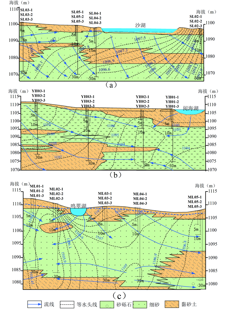
图7 宁夏平原典型人工补给湖泊岸带地下水二维流场图(阅海湖和沙湖数据来自文献[25]和[26]) (a)沙湖;(b)阅海湖;(c)鸣翠湖
Fig.7 Two-dimensional groundwater flow field in the coastal zone of typical a.pngicial recharge lakes in Ningxia Plain
| [1] | 王焰新, 杜尧, 邓娅敏, 等. 湖底地下水排泄与湖泊水质演化[J]. 地质科技通报, 2022, 41(1): 1-10. |
| [2] | SU X S, XU W, DU S H. Responses of groundwater vulnerability to a.pngicial recharge under extreme weather conditions in Shijia-zhuang City, China[J]. Journal of Water Supply(Research and Technology-Aqua), 2014, 63(3): 224-238. |
| [3] | 范伟, 章光新, 李然然. 湿地地表水-地下水交互作用的研究综述[J]. 地球科学进展, 2012, 27(4): 413-423. |
| [4] | MEIXNER T, MANNING A H, STONESTROM D A, et al. Implications of projected climate change for groundwater recharge in the western United States[J]. Journal of Hydrology, 2016, 534: 124-138. |
| [5] | 章光新, 尹雄锐, 冯夏清. 湿地水文研究的若干热点问题[J]. 湿地科学, 2008, 6(2): 105-115. |
| [6] | YANG N, ZHOU P P, WANG G C, et al. Hydrochemical and isotopic interpretation of interactions between surface water and groundwater in Delingha, Northwest China[J]. Journal of Hydrology, 2021, 598: 126243. |
| [7] | KONG F C, SHA Z J, LUO X, et al. Evaluation of lacustrine groundwater discharge and associated nutrients, trace elements and DIC loadings into Qinghai Lake in Qinghai-Tibetan Plateau, using radium isotopes and hydrological methods[J]. Chemical Geology, 2019, 510: 31-46. |
| [8] | 蔡月梅, 王文祥, 张明江, 等. 吐鲁番盆地地表水和地下水主要化学成分的形成与演化[J]. 现代地质, 2016, 30(3): 680-687. |
| [9] | 张皓月, 胡晓农, 王旭升. 巴丹东、西湖地貌演化及其对湖泊水体特征的影响[J]. 现代地质, 2017, 31(2): 406-414. |
| [10] | 魏佳明, 崔丽娟, 李伟, 等. 稳定同位素在湿地水文研究中的应用现状与前景[J]. 湿地科学与管理, 2016, 12(1): 62-65. |
| [11] | QIAN H, WU J H, ZHOU Y H, et al. Stable oxygen and hydrogen isotopes as indicators of lake water recharge and evaporation in the lakes of the Yinchuan Plain[J]. Hydrological Processes, 2014, 28(10): 3554-3562. |
| [12] | 郭华明, 倪萍, 贾永锋, 等. 内蒙古河套盆地地表水-浅层地下水化学特征及成因[J]. 现代地质, 2015, 29(2): 229-237. |
| [13] | 朱冬楠. 基于同位素技术和水文地球化学的寒旱区人工控制湖泊研究[D]. 呼和浩特: 内蒙古农业大学, 2014. |
| [14] | BIGGS T W, LAI C T, CHANDAN P, et al. Evaporative fractions and elevation effects on stable isotopes of high elevation lakes and streams in arid western Himalaya[J]. Journal of Hydrology, 2015, 522: 239-249. |
| [15] | GIBSON J J, BIRKS S J, YI Y. Stable isotope mass balance of lakes: A contemporary perspective[J]. Quaternary Science Reviews, 2016, 131: 316-328. |
| [16] | 王磊, 章光新. 扎龙湿地地表水与浅层地下水的水文化学联系研究[J]. 湿地科学, 2007, 5(2): 166-173. |
| [17] | 陈建生, 彭靖, 詹泸成, 等. 鄱阳湖流域河水、湖水及地下水同位素特征分析[J]. 水资源保护, 2015, 31(4): 1-7. |
| [18] | 李静, 吴华武, 李云良, 等. 基于环境同位素的鄱阳湖与长江关系变化解析[J]. 长江流域资源与环境, 2020, 29(1): 164-173. |
| [19] | 许秀丽, 李云良, 高博, 等. 黄河中游汾河入黄口湿地水源组成与地表地下水转化关系[J]. 湖泊科学, 2022, 34(1): 247-261. |
| [20] | 李延林, 邱小琮. 沙湖的水环境容量和污染物总量控制[J]. 水土保持通报, 2019, 39(5): 272-277. |
| [21] | 王燕, 刘彦斌, 赵红雪, 等. 半咸水宁夏沙湖沉积物中重金属的分布特征、潜在生态风险及来源解析[J]. 环境化学, 2023, 42(10): 3287-3300. |
| [22] | 褚阳, 张鑫. 宁夏鸣翠湖富营养化评价及空间分布特征[J]. 绿色科技, 2021, 23(6): 34-37. |
| [23] | 钟艳霞, 罗玲玲, 虎雪姣, 等. 银川市鸣翠湖湿地水质评价与污染物空间分布研究[J]. 中国农学通报, 2013, 29(26): 100-105. |
| [24] | 尹茂, 赵学欢. 银川河东机场工程地质环境及工程地质适宜性研究[J]. 山东工业技术, 2016(1): 80, 90. |
| [25] | 黄小琴, 张一冰, 李英, 等. 银川市湖泊—地下水转化关系: 以阅海湖为例[J]. 干旱区研究, 2019, 36(6): 1344-1350. |
| [26] | 徐兆祥, 方磊, 黄小琴, 等. 银川平原沙湖与湖岸带地下水转化关系研究[J]. 人民黄河, 2022, 44(增2): 159-161. |
| [27] | RICE K C, HORNBERGER G M. Comparison of hydrochemical tracers to estimate source contributions to peak flow in a small, forested, headwater catchment[J]. Water Resources Research, 1998, 34(7): 1755-1766. |
| [28] |
LIU F, SONG X F, YANG L H, et al. The role of anthropogenic and natural factors in shaping the geochemical evolution of groundwater in the Subei Lake Basin, Ordos energy base, Northwestern China[J]. The Science of the Total Environment, 2015, 538: 327-340.
DOI PMID |
| [29] | 张人权, 梁杏, 靳孟贵, 等. 水文地质学基础[M]. 6版. 北京: 地质出版社, 2011. |
| [30] | 苏小四, 林学钰, 廖资生, 等. 黄河水δ18O、δD和3H的沿程变化特征及其影响因素研究[J]. 地球化学, 2003, 32(4): 349-357. |
| [31] | 苏小四, 林学钰. 银川平原地下水循环及其可更新能力评价的同位素证据[J]. 资源科学, 2004, 26(2): 29-35. |
| [32] | 尹立河, 陶正平, 李瑛, 等. 鄂尔多斯高原乞盖淖地下水与湖水动态补排关系研究[J]. 盐湖研究, 2010, 18(1): 33-37. |
| [1] | 张一范, 高远, 陈积权, 黄帅, 海伦, 毋正轩, 杨柳, 董甜. 松辽盆地晚白垩世湖相白云岩碳氧同位素特征及其古环境意义[J]. 现代地质, 2023, 37(05): 1243-1253. |
| [2] | 李泽岩, 曹文庚, 王卓然, 李谨丞, 任宇. 内蒙古河套灌区浅层地下水化学特征和灌溉适宜性分析[J]. 现代地质, 2022, 36(02): 418-426. |
| [3] | 胡泽祥, 赵学钦, 李松, 李军亚, 王玉珏, 杨洛. 色达—松潘断块温泉水文地球化学特征及成因分析[J]. 现代地质, 2022, 36(02): 484-493. |
| [4] | 赵明坤, 孙亚军, 段忠丰, 沈权伟, 路桂景. 河南漯河市明化镇组温热水地球化学特征及成因[J]. 现代地质, 2022, 36(02): 507-514. |
| [5] | 汪超, 王瑞廷, 刘云华, 薛玉山, 胡西顺, 牛亮. 陕西商南三官庙金矿床流体包裹体及C-H-O-S稳定同位素研究[J]. 现代地质, 2021, 35(06): 1551-1564. |
| [6] | 李波, 吴璇, 张翼飞, 徐聪聪, 刘春伟, 关琴, 罗斐. 山东柴汶河下游古近系朱家沟组含水岩组水文地质特征及地下水富集模式[J]. 现代地质, 2021, 35(03): 675-681. |
| [7] | 张春潮, 李向全, 马剑飞, 付昌昌, 白占学. 基于水化学及稳定同位素的西藏察雅地下热水成因研究[J]. 现代地质, 2021, 35(01): 199-208. |
| [8] | 蒋苏扬, 黄文辉, 张永生. 鄂尔多斯盆地西缘中奥陶统地球化学特征及古环境意义[J]. 现代地质, 2020, 34(03): 545-553. |
| [9] | 李娜, 周训, 郭娟, 拓明明, 徐艳秋. 四川省盐源县盐泉的特征与形成[J]. 现代地质, 2020, 34(01): 177-188. |
| [10] | 霍冬雪, 周训, 刘海生, 余鸣潇, 张彧齐. 云南祥云县王家庄碱性温泉水化学特征与成因分析[J]. 现代地质, 2019, 33(03): 680-690. |
| [11] | 陆三明, 李建设, 阮林森, 赵丽丽, 黄凡, 王波华, 张怀东. 安徽省金寨县沙坪沟钼矿床稳定同位素地球化学特征[J]. 现代地质, 2019, 33(02): 262-270. |
| [12] | 徐浩, 张闯, 庞雅庆, 曹豪杰, 刘佳林, 刘文泉. 广东长排铀矿床成矿流体特征[J]. 现代地质, 2018, 32(05): 902-912. |
| [13] | 苏春田, 聂发运, 邹胜章, 赵光帅, 罗飞, 黄奇波, 巴俊杰, 李小盼, 梁嘉鹏, 杨杨. 湖南新田富锶地下水水化学特征与成因分析[J]. 现代地质, 2018, 32(03): 554-564. |
| [14] | 张振国, 何江涛, 王磊, 彭聪. 衡水地区深层地下水水化学特征及其演化过程[J]. 现代地质, 2018, 32(03): 565-573. |
| [15] | 赖昕, 庞保成, 李院强, 张青伟, 吕嘉文, 周业泉, 李培荣. 广西昭平湾岛金矿的成因:流体包裹体和H-O-S-Pb同位素地球化学约束[J]. 现代地质, 2017, 31(05): 1006-1021. |
| 阅读次数 | ||||||
|
全文 |
|
|||||
|
摘要 |
|
|||||