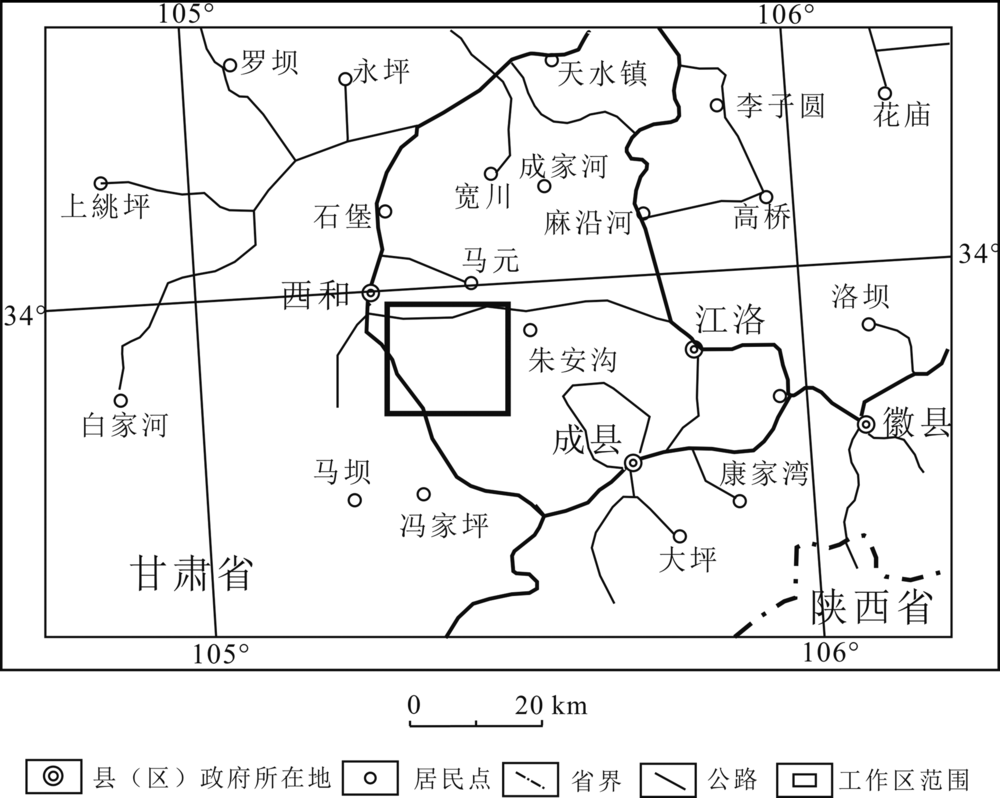
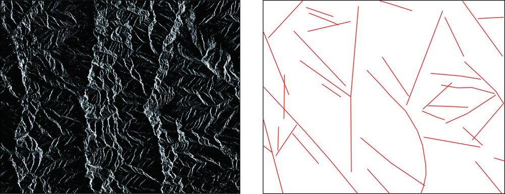
| [1] |
连琛芹. 半裸露区遥感找矿信息提取研究[D]. 北京: 中国地质大学(北京), 2020:1-42.
|
| [2] |
连琛芹, 姚佛军, 陈懋弘, 等. GF-5高光谱数据在植被覆盖区的蚀变信息提取研究——以广东省玉水铜矿为例[J]. 现代地质, 2020, 34(4):48-54.
|
| [3] |
连琛芹, 姚佛军, 杨建民, 等. 半裸露区遥感蚀变信息提取研究——以甘肃玛曲地区为例[J]. 现代地质, 2019, 33(5):1079-1085.
|
| [4] |
代晶晶. 埃塞俄比亚西部岩浆熔离型铁矿遥感找矿模型[J]. 遥感技术与应用, 2012, 27(3):380-386.
|
| [5] |
CRÓSTA A P, SABINE C, TARANIK J V. Hydrothermal alteration mapping at Bodie, California, using AVIRIS hyperspectral data[J]. Remote Sensing of Environment, 1998, 65(3):309-319.
|
| [6] |
张玉君, 曾朝铭, 陈薇. ETM+(TM)蚀变遥感异常提取方法研究与应用——方法选择和技术流程[J]. 国土资源遥感, 2003, 15(2):44-49.
|
| [7] |
姚佛军. 中国典型斑岩铜矿遥感蚀变分带模型研究[D]. 北京: 中国地质大学(北京), 2012:1-238.
|
| [8] |
姚佛军, 杨建民, 耿新霞. 雷达数据在地质构造识别中的初步研究[J]. 矿床地质, 2010, 29(S1):695-696.
|
| [9] |
代晶晶. PALSAR及RADARSAT2全极化雷达数据在地质构造应用中的研究[J]. 地质与勘探, 2011, 47(4):719-725.
|
| [10] |
姚佛军, 焦鹏程, 赵艳军, 等. 干盐湖区隐伏控卤构造遥感识别研究——以马海盐湖为例[J]. 地质学报, 2021, 95(7):2225-2237.
|
| [11] |
唐超, 陈建平, 张瑞丝, 等. 基于Aster遥感数据的班怒成矿带矿化蚀变信息提取[J]. 遥感技术与应用, 2013, 28(1):122-128.
|
| [12] |
刘雷震, 姚佛军, 武建军, 等. 多源数据在西藏多龙矿集区找矿实践中的应用[J]. 北京师范大学学报(自然科学版), 2016, 52(2):184-188.
|
| [13] |
陈三明, 钱建平, 陈宏毅. 桂东南植被覆盖区的抗干扰遥感蚀变信息优化提取与找矿预测[J]. 桂林理工大学学报, 2010, 30(1):33-40.
|
| [14] |
LIU L, ZHUANG D F, ZHOU J, et al. Alteration mineral mapping using masking and Crosta technique for mineral exploration in mid-vegetated areas: a case study in Areletuobie, Xinjiang (China)[J]. International Journal of Remote Sensing, 2011, 32(7):1931-1944.
|
| [15] |
刘磊, 周军, 尹芳, 等. 基于ASTER数据的巴里坤地区蚀变矿物填图及找矿[J]. 遥感技术与应用, 2013, 28(4):556-561.
|
| [16] |
赵玉梅, 刘磊, 周军, 等. 新疆乌什塔拉地区遥感、化探、地质综合找矿研究[J]. 地质找矿论丛, 2016, 31(1):135-141.
|
| [17] |
耿新霞, 杨建民, 姚佛军, 等. 新疆阿勒泰阿巴宫铁矿遥感找矿综合信息研究[J]. 地质论评, 2010, 56(3):365-373.
|
 ), 姚佛军3(