

现代地质 ›› 2019, Vol. 33 ›› Issue (05): 1070-1078.DOI: 10.19657/j.geoscience.1000-8527.2019.05.14
孙岳1( ), 潘家永1, 陈正乐1,2, 韩凤彬2, 刘文恒1, 肖伟峰2
收稿日期:2018-09-02
修回日期:2018-12-06
出版日期:2019-10-26
发布日期:2019-10-28
作者简介:孙 岳,男,讲师,博士,1986年出生,构造地质学专业,主要从事数学地质与构造地质的教学研究。Email: sy0136@163.com。
基金资助:
SUN Yue1(), PAN Jiayong1, CHEN Zhengle1,2, HAN Fengbin2, LIU Wenheng1, XIAO Weifeng2
Received:2018-09-02
Revised:2018-12-06
Online:2019-10-26
Published:2019-10-28
摘要:
为了理清地形地貌对砂岩型铀矿赋存的制约作用,基于GIS技术,利用DEM影像数据提取了中卡兹库姆地区高程、坡度、坡向、地形起伏度及条带剖面等各类地貌因子,并与研究区探明的砂岩型铀矿进行空间关联与定量化分析。研究结果表明砂岩型铀矿赋存的有利地形地貌条件:高程为100~400 m、坡度为0°~5°、地形起伏度为10~35 m、亚流域面积-高程积分值为0.3~0.6;中卡兹库姆地区存在4个较为明显的夷平面,高程分别为:Ⅰ级2 200 m,Ⅱ级1 600 m,Ⅲ级1 100 m,Ⅳ级330~400 m,砂岩型铀矿发育于Ⅳ级夷平面附近;砂岩型铀矿集中于低海拔和低地形起伏度的地区,二者可作为砂岩型铀矿找矿预测的主要参考因素。最后根据地貌因子圈定了中卡兹库姆地区砂岩型铀矿赋存的有利区域,为该区砂岩型铀矿找矿提供依据。
中图分类号:
孙岳, 潘家永, 陈正乐, 韩凤彬, 刘文恒, 肖伟峰. 乌兹别克中卡兹库姆地貌特征对砂岩型铀矿赋存的制约[J]. 现代地质, 2019, 33(05): 1070-1078.
SUN Yue, PAN Jiayong, CHEN Zhengle, HAN Fengbin, LIU Wenheng, XIAO Weifeng. Geomorphic Features and Its Constraint to Sandstone-hosted U Deposits Occurrence in Mid-Kezelkum, Uzbekistan[J]. Geoscience, 2019, 33(05): 1070-1078.

图1 研究区DEM及铀矿点分布图 1.第四系;2.新近系;3.古近系;4.白垩系;5.元古宇与古生界变质岩;6.中酸性侵入岩;7.地层界线;8.断层;9.砂岩型铀矿
Fig.1 The DEM and uranium deposits distribution map of the study area
| 高程/m | 百分比/% | 累积百分比/% |
|---|---|---|
| <500 | 67.84 | 67.84 |
| 500~1 000 | 24.66 | 92.50 |
| 1 000~1 500 | 4.88 | 97.38 |
| 1 500~2 000 | 1.92 | 99.30 |
| 2 000~2 500 | 0.60 | 99.90 |
| 2 500~3 000 | 0.07 | 99.97 |
| 3 000~3 500 | 0.02 | 99.99 |
| >3 500 | 0.01 | 100 |
表1 中卡兹库姆地区高程统计
Table 1 The elevation statistic value of the Mid-Kezelkum area
| 高程/m | 百分比/% | 累积百分比/% |
|---|---|---|
| <500 | 67.84 | 67.84 |
| 500~1 000 | 24.66 | 92.50 |
| 1 000~1 500 | 4.88 | 97.38 |
| 1 500~2 000 | 1.92 | 99.30 |
| 2 000~2 500 | 0.60 | 99.90 |
| 2 500~3 000 | 0.07 | 99.97 |
| 3 000~3 500 | 0.02 | 99.99 |
| >3 500 | 0.01 | 100 |
| 铀矿点 | 最大高程/m | 最小高程/m | 平均值/m | 标准差/m |
|---|---|---|---|---|
| 637 | 129 | 343 | 147.4 |
表2 铀矿点高程统计值
Table 2 The elevation statistic value of the uranium deposits
| 铀矿点 | 最大高程/m | 最小高程/m | 平均值/m | 标准差/m |
|---|---|---|---|---|
| 637 | 129 | 343 | 147.4 |
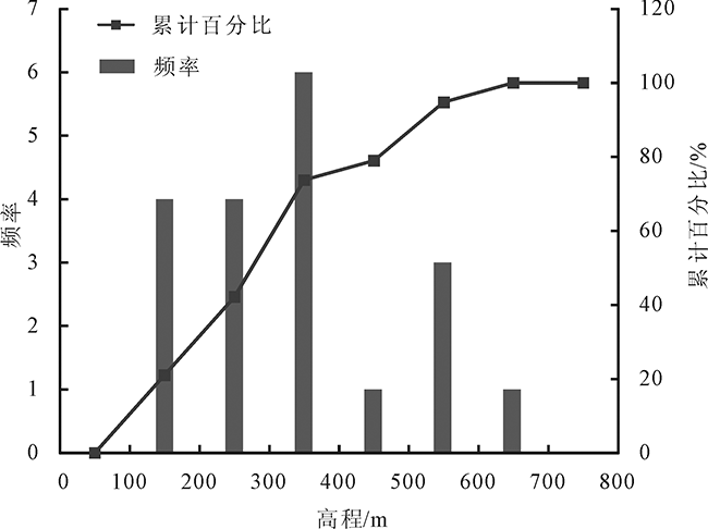
图2 砂岩型铀矿高程分布直方图
Fig.2 The elevation distribution histogram of the sandstone-hosted U deposits
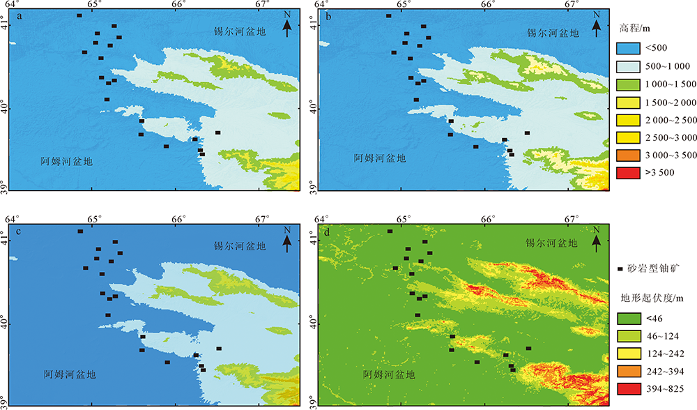
图3 研究区4种高程分析图 a.最小高程图;b.最大高程图;c.平均高程图;d.地形起伏度图
Fig.3 Four types of DEM maps of the study area
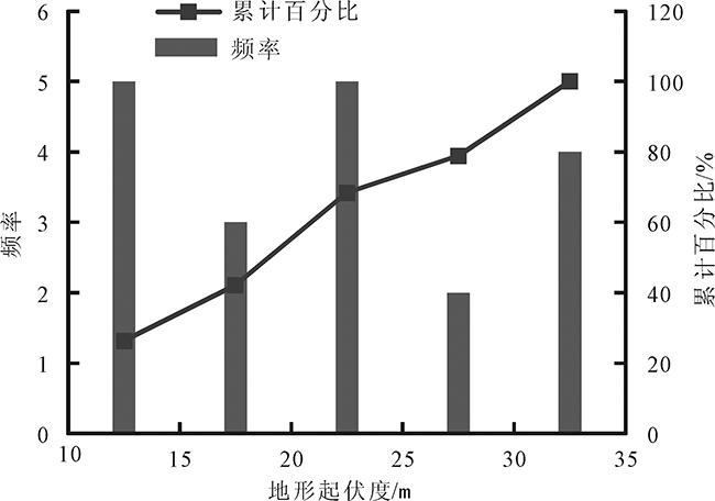
图4 砂岩型铀矿地形起伏度分布直方图
Fig.4 The topographic relief distribution histogram of the sandstone-hosted U deposits

图5 中卡兹库姆地区坡度图
Fig.5 The slope map of the Mid-Kezelkum area
| 坡度划分 | 百分比/% | 累计百分比/% |
|---|---|---|
| 平坦坡<5° | 83.84 | 83.84 |
| 缓坡5°~15° | 11.35 | 95.19 |
| 斜坡15°~25° | 3.17 | 98.36 |
| 陡坡25°~35° | 1.29 | 99.65 |
| 急坡35°~45° | 0.29 | 99.94 |
| 险坡>45° | 0.06 | 100 |
表3 中卡兹库姆地区坡度统计
Table 3 The slope statistic value of the Mid-Kezelkum area
| 坡度划分 | 百分比/% | 累计百分比/% |
|---|---|---|
| 平坦坡<5° | 83.84 | 83.84 |
| 缓坡5°~15° | 11.35 | 95.19 |
| 斜坡15°~25° | 3.17 | 98.36 |
| 陡坡25°~35° | 1.29 | 99.65 |
| 急坡35°~45° | 0.29 | 99.94 |
| 险坡>45° | 0.06 | 100 |
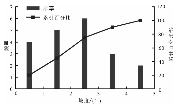
图6 砂岩型铀矿坡度分布直方图
Fig.6 The gradient distribution histogram of the sandstone-hosted U deposits
| 铀矿点 | 最小坡向/(°) | 最大坡向/(°) | 平均值/(°) | 标准差/(°) |
|---|---|---|---|---|
| 6.34 | 306.25 | 195.88 | 97.33 |
表4 砂岩型铀矿坡向统计表
Table 4 The aspect statistic value of the sandstone-hosted U deposits
| 铀矿点 | 最小坡向/(°) | 最大坡向/(°) | 平均值/(°) | 标准差/(°) |
|---|---|---|---|---|
| 6.34 | 306.25 | 195.88 | 97.33 |

图7 砂岩型铀矿坡向分布直方图
Fig.7 The aspect distribution histogram of the sandstone-hosted U deposits
| 地点 | 最小值 | 最大值 | 平均值 | 标准差 | |
|---|---|---|---|---|---|
| 亚流域 | 0.009 | 0.874 | 0.414 | 0.117 | |
| 铀矿点 | 0.315 | 0.677 | 0.441 | 0.094 |
表5 亚流域及砂岩型铀矿所在亚流域HI统计
Table 5 The hypsometric integral (HI) statistic value of the sub-basins and sandstone-hosted U deposits
| 地点 | 最小值 | 最大值 | 平均值 | 标准差 | |
|---|---|---|---|---|---|
| 亚流域 | 0.009 | 0.874 | 0.414 | 0.117 | |
| 铀矿点 | 0.315 | 0.677 | 0.441 | 0.094 |
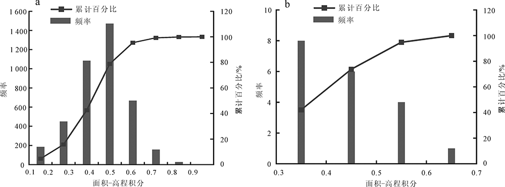
图8 面积-高程积分分布直方图(a.亚流域HI;b.砂岩型铀矿所在亚流域HI)
Fig.8 The hypsometric integral (HI) distribution histogram of the sub-basins and sandstone-hosted U deposits

图9 中卡兹库姆地区a、b、c条带剖面线高程
Fig.9 The graphs of the a, b and c swath profiles in the Mid-Kezelkum
| 高程 | 坡度 | 坡向 | 地形起伏度 | 面积-高程积分 | |
|---|---|---|---|---|---|
| 高程 | 1 | ||||
| 坡度 | 0.112 053 | 1 | |||
| 坡向 | 0.544 539 | 0.205 519 | 1 | ||
| 地形起伏度 | 0.723 929 | 0.281 929 | 0.471 725 | 1 | |
| 面积-高程积分 | -0.211 66 | -0.284 03 | -0.452 61 | -0.165 63 | 1 |
表6 地形因子相关系数
Table 6 The terrain factor correlation coefficient
| 高程 | 坡度 | 坡向 | 地形起伏度 | 面积-高程积分 | |
|---|---|---|---|---|---|
| 高程 | 1 | ||||
| 坡度 | 0.112 053 | 1 | |||
| 坡向 | 0.544 539 | 0.205 519 | 1 | ||
| 地形起伏度 | 0.723 929 | 0.281 929 | 0.471 725 | 1 | |
| 面积-高程积分 | -0.211 66 | -0.284 03 | -0.452 61 | -0.165 63 | 1 |
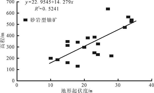
图10 高程与地形起伏度关系图
Fig.10 The relation diagram of the topographic relief and elevation

图11 中卡兹库姆地区砂岩型铀矿赋存有利区(红色)
Fig.11 The ore prospective area of sandstone-hosted U depo-sit in Mid-Kezelkum
| [1] | 刘少峰, 王陶, 张会平, 等. 数字高程模型在地表过程研究中的应用[J]. 地学前缘, 2005,12(1):303-309. |
| [2] | 张会平, 杨农, 张岳桥, 等. 岷江水系流域地貌特征及其构造指示意义[J]. 第四纪研究, 2006,26(1):126-135. |
| [3] | 施炜. 黄河中游晋陕峡谷的DEM 流域特征分析及其新构造意义[J]. 第四纪研究, 2008,28(2):288-298. |
| [4] | FONT M, AMORESE D, LAGARDE J L. DEM and GIS analysis of the stream gradient index to evaluate effects of tectonics: The Normandy Intraplate area (NW France)[J]. Geomorphology, 2010,119:172-180. |
| [5] | 李利波, 徐刚, 胡建民, 等. 基于DEM的活动构造研究[J]. 中国地质, 2012,39(3):595-604. |
| [6] | GAO M X, ZEILINGER G, XU X W, et al. DEM and GIS ana-lysis of geomorphic indices for evaluating recent uplift of the northeastern margin of the Tibetan Plateau, China[J]. Geomorphology, 2013,190:61-72. |
| [7] | 秦翔, 施炜, 李恒强, 等. 基于DEM 地形特征因子的青藏高原东北缘宁南弧形断裂带活动性分析[J]. 第四纪研究, 2017,37(2):213-313. |
| [8] | GONG L W, LI N, FAN Q C, et al. Mapping the topography and cone morphology of the Dalinor volcanic swarm in Inner Mongolia with remote sensing and DEM data[J]. Frontiers of Earth Science, 2016,10(3):578-594. |
| [9] | 刘新星, 陈毓川, 王登红, 等. 基于DEM的南岭东段离子吸附型稀土矿成矿地貌条件分析[J]. 地球学报, 2016,37(2):174-184. |
| [10] | LEHMANN B. Uranium ore deposits[J]. Reviews in Economic Geology, 2008(2):16-26. |
| [11] | 荣辉, 焦养泉, 吴立群, 等. 松辽盆地南部钱家店铀矿床后生蚀变作用及其对铀成矿的约束[J]. 地球科学, 2016,41(1):153-166. |
| [12] | 王飞飞, 刘池洋, 邱欣卫, 等. 世界砂岩型铀矿探明资源的分布及特征[J]. 地质学报, 2017,91(9):2021-2046. |
| [13] | 陈正乐, 刘健, 宫红良, 等. 准噶尔盆地北部新生代构造活动特征及其对砂岩型铀矿的控制作用[J]. 地质学报, 2006,80(1):101-111. |
| [14] | JAIRETH S, MCKAY A, LAMBERT I. Association of large sandstone uranium deposits with hydrocarbons[J]. AUSGEO News, 2008,89:1-6. |
| [15] | 付勇, 魏帅超, 金若时, 等. 我国砂岩型铀矿分带特征研究现状及存在问题[J]. 地质学报, 2016,90(12):3519-3544. |
| [16] | 秦明宽, 何中波, 刘章月, 等. 准噶尔盆地砂岩型铀矿成矿环境与找矿方向研究[J]. 地质论评, 2017,63(5):1255-1269. |
| [17] | 姚振凯, 向伟东, 张子敏, 等. 中央克兹勒库姆区域构造演化及铀成矿特征[J]. 世界核地质科学, 2011,28(2):84-89. |
| [18] | 朱捌. 乌兹别克中卡兹库姆铀成矿省地浸砂岩型铀矿特征[J]. 华南铀矿地质, 2000,17(1/2):106-117. |
| [19] | 邓平. 乌兹别克斯坦中卡兹库姆成矿省铀成矿规律[J]. 华南铀矿地质, 2001,18(2):25-32. |
| [20] | 赵凤民. 中亚铀矿地质[R]. 北京: 核工业北京地质研究院, 2013: 289-336. |
| [21] | 国际原子能机构. 世界铀矿床录[M]. 周维勋, 郭福生,译. 北京: 原子能出版社, 2000:184-191. |
| [22] | International Atomic Energy Agency (IAEA). World Distribution of Uranium Deposits (UDEPO)[M]. Vienna:IAEA, 2018:1-247. |
| [23] | 洪顺英, 申旭辉, 荆凤, 等. 基于SRTM-DEM的阿尔泰山构造地貌特征分析[J]. 国土资源遥感, 2007,19(3):62-68. |
| [24] | REN Z K, ZHANG Z Q, DAI F C, et al. Topographic changes due to the 2008 Mw 7.9 Wenchuan earthquake as revealed by the differential DEM method[J]. Geomorphology, 2014,217:122-130. |
| [25] | 宿渊源, 张景发, 何仲太, 等. 资源卫星三号DEM数据在活动构造定量研究中的应用评价[J]. 国土资源遥感, 2015,27(4):122-130. |
| [26] | STRAHLER A N. Hypsometric (area-altitude) analysis of erosional topography[J]. Geological Society of America Bulletin, 1952,63:1117-1142. |
| [27] | PIKE R J, WILSON S E. Elevation-relief ratio, hypsometric integral, and geomorphic area-altitude analysis[J]. Geological Society of America Bulletin, 1971,82(4):1079-1084. |
| [28] | 祝士杰, 汤国安, 李发源, 等. 基于DEM的黄土高原面积高程积分研究[J]. 地理学报, 2013,68(7):921-932. |
| [29] | 邹斌文, 马维峰, 龙昱, 等. 基于ArcGIS 的条带剖面提取方法在地貌分析中的应用[J]. 地理与地理信息科学, 2011,27(3):42-44. |
| [30] | 刘池洋, 赵红格, 桂小军, 等. 鄂尔多斯盆地演化-改造的时空坐标及其成藏(矿)响应[J]. 地质学报, 2006,80(5):617-638. |
| [31] | 别列里曼A. И. 水成铀矿床[R].熊福清, 孙西田,译. 咸阳:核工业西北地质局203研究所, 1995:1-261. |
| [32] | 张金带, 徐高中, 陈安平, 等. 我国可地浸砂岩型铀矿成矿模式初步探讨[J]. 铀矿地质, 2005,21(3):139-145. |
| [1] | 蔡胤璐, 武法东, 韩晋芳, 黄震, 周莹, 刘宝印, 谌杨杨. 沂蒙山世界地质公园岱崮地貌特征、成因及演化[J]. 现代地质, 2023, 37(04): 1065-1074. |
| [2] | 王瑞丰, 翟延亮, 张宝君, 申国强, 曾一凡. 基于GIS与AHP耦合技术的承德地区地质灾害危害性评价[J]. 现代地质, 2023, 37(04): 1023-1032. |
| [3] | 权雪瑞, 黄靥欢, 刘春, 郭长宝. 川藏铁路线V形深切河谷地形地震放大效应数值模拟[J]. 现代地质, 2021, 35(01): 38-46. |
| [4] | 胡妍, 胡永兴, 张翔, 杨涛, 欧扬剑. 鄂尔多斯盆地西南缘镇原地区砂岩型铀矿元素地球化学特征及地质意义[J]. 现代地质, 2020, 34(06): 1153-1165. |
| [5] | 邱余波, 陈虹, 杨军锋, 张占峰, 蒋宏, 杜默, 李刚. 伊犁盆地阔斯加尔铀成矿区西山窑组古地下水动力系统[J]. 现代地质, 2019, 33(02): 431-439. |
| [6] | 王超, 董少刚, 刘晓波, 杨阳, 李政葵. 城市化对呼和浩特市潜水补给影响研究[J]. 现代地质, 2018, 32(03): 574-583. |
| [7] | 崔玉良,王根厚,郎欣欣,曾志方. 基于MAPGIS的含量-面积分形法确定元素异常下限及圈定异常区:以湖南阳明山地区为例[J]. 现代地质, 2016, 30(4): 811-817. |
| [8] | 何仲太,侯建军,宿渊源. IRS-P5影像提取DEM技术在大青山山前断裂古地震研究的应用[J]. 现代地质, 2014, 28(6): 1243-1251. |
| [9] | 封志兵,聂逢君,江丽,曾建刚,严兆彬,李红星. 重力场特征与砂岩型铀矿的关系及地质意义[J]. 现代地质, 2014, 28(4): 841-849. |
| [10] | 席振,高光明,肖娟,张杨. 基于GIS的秘鲁南部多源信息成矿预测研究[J]. 现代地质, 2013, 27(1): 108-115. |
| [11] | 苗爱生, 陆琦, 刘惠芳, 肖平. 鄂尔多斯盆地东胜砂岩型铀矿中铀矿物的电子显微镜研究[J]. 现代地质, 2010, 24(4): 785-792. |
| [12] | 薛伟, 薛春纪, 池国祥, 彭云彪, 王凯. 鄂尔多斯盆地东胜砂岩型铀矿微量和稀土元素地球化学特征[J]. 现代地质, 2010, 24(4): 776-784. |
| [13] | 张保祥 万力 余成 孟凡海. 基于熵权与GIS耦合的DRASTIC地下水脆弱性模糊优选评价[J]. 现代地质, 2009, 23(1): 150-156. |
| [14] | 李贵中,白建梅,习铁宏,刘洪林,王德建,王勃. GIS支持下的煤层气目标区模糊综合评价模型[J]. 现代地质, 2008, 22(1): 103-106. |
| [15] | 薛春纪,薛伟,康明,涂其军,杨友运. 鄂尔多斯盆地流体动力学过程及其砂岩型铀矿化 [J]. 现代地质, 2008, 22(1): 1-8. |
| 阅读次数 | ||||||
|
全文 |
|
|||||
|
摘要 |
|
|||||