

现代地质 ›› 2025, Vol. 39 ›› Issue (02): 478-494.DOI: 10.19657/j.geoscience.1000-8527.2025.025
肖粤新1,2,3,4( ), 孙泽龙1,3(), 闵英姿1,3, 杨鹏至1,3, 田兆飞1,3, 成明1, 兰建梅2
出版日期:2025-04-10
发布日期:2025-05-08
通信作者:
孙泽龙,男,助理工程师,1988年出生,主要从事地表基质调查监测、自然资源综合观测研究工作。Email: sunzelong@mail.cgs.gov.cn。作者简介:肖粤新,男,工程师,1994年出生,主要从事地表基质调查监测、自然资源综合观测研究工作。Email: xiaoyuexin@mail.cgs.gov.cn。
基金资助:
XIAO Yuexin1,2,3,4(), SUN Zelong1,3(), MIN Yingzi1,3, YANG Pengzhi1,3, TIAN Zhaofei1,3, CHENG Ming1, LAN Jianmei2
Published:2025-04-10
Online:2025-05-08
摘要: 本文以安徽省皖南山区为研究对象,基于GIS技术和CSLE模型定量评估了1990年、2000年、2010年和2020年4期研究区土壤侵蚀时空变化特征,并且重点探讨了土壤侵蚀与土地利用、坡度、海拔间的关系。结果表明:1990—2020年4期研究区土壤侵蚀量分别为5719万t、4893万t、6669万t、6565万t,平均土壤侵蚀模数分别为1336 t/(km2·a)、1143 t/(km2·a)、1558 t/(km2·a)、1534 t/(km2·a),总体上土壤侵蚀状况呈现加剧趋势,主要体现在部分区域从轻微、轻度侵蚀向更高程度的侵蚀等级转移;土壤侵蚀程度以轻微、轻度侵蚀为主,空间分布总体特点为北低南高,池州、黄山和宣城市的多山地区是水土流失重点防治区域。土壤侵蚀的空间分布与土地利用、坡度、海拔等密切相关,林地土壤侵蚀程度高于耕地,这与土地利用方式的分布程度有关;土壤侵蚀模数随坡度和海拔的增加而增大,坡度25°~35°区域内土壤侵蚀量最大,年平均土壤侵蚀总量为960.92万t,占比32.79%,海拔200~500 m区域内土壤侵蚀量最大,年平均土壤侵蚀总量为1306.75万t,占比39.24%,因此未来须进一步加强这些区域的生态恢复及水土保持措施建设,建议通过增加植被覆盖、合理规划坡地农业等措施来改善水土流失现状。本研究结果可为皖南山区的水土流失综合治理提供科学依据。
中图分类号:
肖粤新, 孙泽龙, 闵英姿, 杨鹏至, 田兆飞, 成明, 兰建梅. 皖南山区1990—2020年间土壤侵蚀特征及影响因素[J]. 现代地质, 2025, 39(02): 478-494.
XIAO Yuexin, SUN Zelong, MIN Yingzi, YANG Pengzhi, TIAN Zhaofei, CHENG Ming, LAN Jianmei. Spatiotemporal Dynamics and Drivers of Soil Erosion in the Mountainous Areas of South Anhui from 1990 to 2020[J]. Geoscience, 2025, 39(02): 478-494.

图1 研究区相对位置及行政区划图
Fig.1 Relative location and administrative division map of the study area
| 数据 | 精度 | 来源 |
|---|---|---|
| 中国1 km分辨率逐月降水量数据集 | 1 km | 国家科技基础条件平台—国家地球系统科学数据中心( |
| 土壤质地数据 | 1:100万 | 国家冰川冻土沙漠科学数据中心( |
| 土地利用数据 | 30 m | 地球大数据科学工程数据共享服务系统( |
| NDVI数据集 | 1 km | 中国年度植被指数(NDVI)空间分布数据集,资源环境科学数据注册与出版系统( |
| DEM数据 | 30 m | 地理空间数据云( |
表1 基础数据及其来源
Table 1 Basic data and their resources
| 数据 | 精度 | 来源 |
|---|---|---|
| 中国1 km分辨率逐月降水量数据集 | 1 km | 国家科技基础条件平台—国家地球系统科学数据中心( |
| 土壤质地数据 | 1:100万 | 国家冰川冻土沙漠科学数据中心( |
| 土地利用数据 | 30 m | 地球大数据科学工程数据共享服务系统( |
| NDVI数据集 | 1 km | 中国年度植被指数(NDVI)空间分布数据集,资源环境科学数据注册与出版系统( |
| DEM数据 | 30 m | 地理空间数据云( |

图2 皖南山区1990—2020年R因子分布图
Fig.2 R factor distribution in the mountainous area of south Anhui from 1990 to 2020
| 年份 | 最大值 (MJ·mm/km-2· h-1·a-1) | 最小值 (MJ·mm/km-2· h-1·a-1) | 平均值 (MJ·mm/km-2· h-1·a-1) |
|---|---|---|---|
| 1990 | 6934.83 | 3995.52 | 4408.07 |
| 2000 | 6065.20 | 2727.08 | 3856.50 |
| 2010 | 8568.40 | 3392.03 | 5150.20 |
| 2020 | 8024.08 | 3899.79 | 5162.78 |
表2 皖南山区1990—2020年降雨侵蚀力因子统计
Table 2 Statistics of rainfall erosivity factors in the mountainous area of south Anhui from 1990 to 2020
| 年份 | 最大值 (MJ·mm/km-2· h-1·a-1) | 最小值 (MJ·mm/km-2· h-1·a-1) | 平均值 (MJ·mm/km-2· h-1·a-1) |
|---|---|---|---|
| 1990 | 6934.83 | 3995.52 | 4408.07 |
| 2000 | 6065.20 | 2727.08 | 3856.50 |
| 2010 | 8568.40 | 3392.03 | 5150.20 |
| 2020 | 8024.08 | 3899.79 | 5162.78 |

图3 皖南山区K因子分布图
Fig.3 K factor distribution in the mountainous area of south Anhui

图4 皖南山区LS因子分布图
Fig.4 LS factor distribution in the mountainous area of south Anhui
| 土地利 用类型 (LUCC) | 植被盖度 (FVC,%) | B值 | 土地利 用类型 (LUCC) | 植被盖度 (FVC,%) | B值 |
|---|---|---|---|---|---|
| 林地 | 0~20 | 0.100 | 草地 | 0~20 | 0.450 |
| 20~40 | 0.080 | 20~40 | 0.240 | ||
| 40~60 | 0.060 | 40~60 | 0.150 | ||
| 60~80 | 0.020 | 60~80 | 0.090 | ||
| 80~100 | 0.004 | 80~100 | 0.043 | ||
| 水域 | - | 0 | 平耕地 | - | 0.230 |
| 建设用地 | - | 0.353 | 坡耕地 | - | 0.470 |
表3 不同LUCC和FVC下的B值
Table 3 B values under different LUCC and FVC
| 土地利 用类型 (LUCC) | 植被盖度 (FVC,%) | B值 | 土地利 用类型 (LUCC) | 植被盖度 (FVC,%) | B值 |
|---|---|---|---|---|---|
| 林地 | 0~20 | 0.100 | 草地 | 0~20 | 0.450 |
| 20~40 | 0.080 | 20~40 | 0.240 | ||
| 40~60 | 0.060 | 40~60 | 0.150 | ||
| 60~80 | 0.020 | 60~80 | 0.090 | ||
| 80~100 | 0.004 | 80~100 | 0.043 | ||
| 水域 | - | 0 | 平耕地 | - | 0.230 |
| 建设用地 | - | 0.353 | 坡耕地 | - | 0.470 |

图5 皖南山区1990—2020年B因子分布图
Fig.5 B factor distribution in the mountainous area of south Anhui from 1990 to 2020

图6 皖南山区1990—2020年E因子分布图
Fig.6 E factor distribution in the mountainous area of south Anhui from 1990 to 2020
| 年份 | 最大值 | 最小值 | 平均值 |
|---|---|---|---|
| 1990 | 1 | 0.084 | 0.622 |
| 2000 | 1 | 0.084 | 0.656 |
| 2010 | 1 | 0.084 | 0.659 |
| 2020 | 1 | 0.084 | 0.670 |
表4 皖南山区E因子特征统计
Table 4 E factor characteristic statistics in the mountainous area of south Anhui
| 年份 | 最大值 | 最小值 | 平均值 |
|---|---|---|---|
| 1990 | 1 | 0.084 | 0.622 |
| 2000 | 1 | 0.084 | 0.656 |
| 2010 | 1 | 0.084 | 0.659 |
| 2020 | 1 | 0.084 | 0.670 |
| 参数 | 坡度 | ||||||
|---|---|---|---|---|---|---|---|
| >25° | 0° | ≤ 5° | 5°~ 10° | 10°~ 15° | 15°~ 20° | 20°~ 25° | |
| T | 1 | 0.1 | 0.221 | 0.305 | 0.575 | 0.705 | 1 |
表5 不同坡度条件下T值
Table 5 T value under different slope conditions
| 参数 | 坡度 | ||||||
|---|---|---|---|---|---|---|---|
| >25° | 0° | ≤ 5° | 5°~ 10° | 10°~ 15° | 15°~ 20° | 20°~ 25° | |
| T | 1 | 0.1 | 0.221 | 0.305 | 0.575 | 0.705 | 1 |

图7 皖南山区T因子分布图
Fig.7 T factor distribution in the mountainous area of south Anhui

图8 皖南山区1990—2020年土壤侵蚀程度分布
Fig.8 Soil erosion degree distribution in the mountainous area of south Anhui from 1990 to 2020
| 不同土壤侵蚀级别的面积(km2)及占比(%) | 平均模数 (t/(km2 ·a)) | 像元模数 最大值 (t/km2 ·a)) | 侵蚀量 (万t) | 强烈及以 上侵蚀量 (万t) | |||||
|---|---|---|---|---|---|---|---|---|---|
| 年份 | 轻微侵蚀 | 轻度侵蚀 | 中度侵蚀 | 强烈侵蚀 | 极强烈侵蚀 | ||||
| 1990 | 21796(50.91) | 11042(25.79) | 8128(18.99) | 1732(4.05) | 110(0.26) | 1336 | 13323 | 5719 | 1492 |
| 2000 | 21594(50.44) | 13215(30.87) | 7029(16.42) | 942(2.20) | 27(0.07) | 1143 | 12130 | 4893 | 761 |
| 2010 | 20468(47.81) | 10555(24.66) | 8409(19.64) | 2978(6.96) | 394(0.92) | 1558 | 16679 | 6669 | 2893 |
| 2020 | 19369(45.24) | 11891(27.78) | 8649(20.20) | 2631(6.15) | 268(0.63) | 1534 | 14966 | 6565 | 2439 |
表6 皖南山区1990—2020土壤侵蚀特征统计
Table 6 Statistics of soil erosion characteristics in the mountainous area of south Anhui from 1990 to 2020
| 不同土壤侵蚀级别的面积(km2)及占比(%) | 平均模数 (t/(km2 ·a)) | 像元模数 最大值 (t/km2 ·a)) | 侵蚀量 (万t) | 强烈及以 上侵蚀量 (万t) | |||||
|---|---|---|---|---|---|---|---|---|---|
| 年份 | 轻微侵蚀 | 轻度侵蚀 | 中度侵蚀 | 强烈侵蚀 | 极强烈侵蚀 | ||||
| 1990 | 21796(50.91) | 11042(25.79) | 8128(18.99) | 1732(4.05) | 110(0.26) | 1336 | 13323 | 5719 | 1492 |
| 2000 | 21594(50.44) | 13215(30.87) | 7029(16.42) | 942(2.20) | 27(0.07) | 1143 | 12130 | 4893 | 761 |
| 2010 | 20468(47.81) | 10555(24.66) | 8409(19.64) | 2978(6.96) | 394(0.92) | 1558 | 16679 | 6669 | 2893 |
| 2020 | 19369(45.24) | 11891(27.78) | 8649(20.20) | 2631(6.15) | 268(0.63) | 1534 | 14966 | 6565 | 2439 |

图9 皖南山区1990—2020年土壤侵蚀程度变化分布
Fig.9 Changes in soil erosion in the mountainous area of south Anhui from 1990 to 2020
| 土壤侵蚀程度 | 2020年 | |||||
|---|---|---|---|---|---|---|
| 轻微 侵蚀 | 轻度 侵蚀 | 中度 侵蚀 | 强烈 侵蚀 | 极强烈 侵蚀 | ||
| 1990年 | 轻微侵蚀 | 18750.17 | 3030.81 | 74.66 | ||
| 轻度侵蚀 | 703.90 | 8505.84 | 1773.97 | 27.71 | 2.52 | |
| 中度侵蚀 | 266.22 | 6766.20 | 1070.95 | |||
| 强烈侵蚀 | 49.52 | 1525.37 | 150.85 | |||
| 极强烈侵蚀 | 111.88 | |||||
表7 皖南山区1990—2020年土壤侵蚀转移矩阵(km2)
Table 7 Soil erosion transfer matrix in the mountainous area of south Anhui from 1990 to 2020 (km2)
| 土壤侵蚀程度 | 2020年 | |||||
|---|---|---|---|---|---|---|
| 轻微 侵蚀 | 轻度 侵蚀 | 中度 侵蚀 | 强烈 侵蚀 | 极强烈 侵蚀 | ||
| 1990年 | 轻微侵蚀 | 18750.17 | 3030.81 | 74.66 | ||
| 轻度侵蚀 | 703.90 | 8505.84 | 1773.97 | 27.71 | 2.52 | |
| 中度侵蚀 | 266.22 | 6766.20 | 1070.95 | |||
| 强烈侵蚀 | 49.52 | 1525.37 | 150.85 | |||
| 极强烈侵蚀 | 111.88 | |||||

图10 1990—2020年林地侵蚀分布图
Fig.10 Distribution map of forest erosion from 1990 to 2020

图11 1990—2020年耕地侵蚀分布图
Fig.11 Distribution map of farmland erosion from 1990 to 2020
| 土地类型 | 年份 | 轻微侵蚀 | 轻度侵蚀 | 中度侵蚀 | 强烈侵蚀 | 极强烈侵蚀 | 剧烈侵蚀 |
|---|---|---|---|---|---|---|---|
| 林地 | 1990 | 4098.61 | 8934.89 | 7665.51 | 1685.38 | 109.17 | 0 |
| 2000 | 5953.92 | 10143.89 | 6132.92 | 859.04 | 25.40 | 0 | |
| 2010 | 5336.53 | 7440.07 | 7168.47 | 2669.90 | 362.00 | 3.82 | |
| 2020 | 4573.79 | 7880.18 | 7347.24 | 2351.72 | 248.64 | 0.00 | |
| 耕地 | 1990 | 16094.06 | 1736.98 | 421.55 | 43.00 | 1.25 | |
| 2000 | 13023.62 | 2709.55 | 866.32 | 79.78 | 11.29 | ||
| 2010 | 12475.30 | 2667.54 | 1105.56 | 291.65 | 30.43 | ||
| 2020 | 11707.10 | 3068.04 | 1161.04 | 253.34 | 20.27 |
表8 皖南1990—2020年林耕地土壤侵蚀面积(km2)
Table 8 Area of soil erosion in forestland and cropland in the mountainous area of south Anhui from 1990 to 2020
| 土地类型 | 年份 | 轻微侵蚀 | 轻度侵蚀 | 中度侵蚀 | 强烈侵蚀 | 极强烈侵蚀 | 剧烈侵蚀 |
|---|---|---|---|---|---|---|---|
| 林地 | 1990 | 4098.61 | 8934.89 | 7665.51 | 1685.38 | 109.17 | 0 |
| 2000 | 5953.92 | 10143.89 | 6132.92 | 859.04 | 25.40 | 0 | |
| 2010 | 5336.53 | 7440.07 | 7168.47 | 2669.90 | 362.00 | 3.82 | |
| 2020 | 4573.79 | 7880.18 | 7347.24 | 2351.72 | 248.64 | 0.00 | |
| 耕地 | 1990 | 16094.06 | 1736.98 | 421.55 | 43.00 | 1.25 | |
| 2000 | 13023.62 | 2709.55 | 866.32 | 79.78 | 11.29 | ||
| 2010 | 12475.30 | 2667.54 | 1105.56 | 291.65 | 30.43 | ||
| 2020 | 11707.10 | 3068.04 | 1161.04 | 253.34 | 20.27 |
| 坡度 (°) | 年份 | 侵蚀 面积 (km2) | 百分比 (%) | 平均 模数 (t/km2 ·a)) | 侵蚀 总量 (万t) | 侵蚀 比例 (%) |
|---|---|---|---|---|---|---|
| < 5 | 1990 | 19636 | 35.84 | 569 | 45.23 | 1.70 |
| 2000 | 18865 | 34.88 | 494 | 42.35 | 1.98 | |
| 2010 | 18269 | 34.28 | 639 | 67.45 | 2.00 | |
| 2020 | 17735 | 33.86 | 650 | 68.34 | 2.18 | |
| 5~8 | 1990 | 6496 | 11.86 | 767 | 78.95 | 3.01 |
| 2000 | 6419 | 11.87 | 683 | 67.79 | 3.17 | |
| 2010 | 6323 | 11.86 | 893 | 105.93 | 3.15 | |
| 2020 | 6093 | 11.63 | 995 | 102.90 | 3.28 | |
| 8~15 | 1990 | 8935 | 16.30 | 1270 | 235.95 | 8.90 |
| 2000 | 8942 | 16.53 | 1092 | 188.51 | 8.81 | |
| 2010 | 8871 | 16.65 | 1466 | 308.54 | 9.18 | |
| 2020 | 8693 | 16.60 | 1577 | 716.83 | 9.10 | |
| 15~25 | 1990 | 10112 | 18.45 | 2263 | 604.60 | 23.05 |
| 2000 | 10181 | 18.82 | 1964 | 467.00 | 21.82 | |
| 2010 | 10158 | 19.06 | 2681 | 788.95 | 23.48 | |
| 2020 | 10143 | 19.36 | 2640 | 716.83 | 22.90 | |
| 25~35 | 1990 | 6845 | 12.49 | 3810 | 894.50 | 34.10 |
| 2000 | 6885 | 12.73 | 3219 | 724.25 | 33.84 | |
| 2010 | 6880 | 12.91 | 4368 | 1162.29 | 34.60 | |
| 2020 | 6897 | 13.16 | 4208 | 1062.63 | 28.60 | |
| 35 | 1990 | 2769 | 5.05 | 5588 | 763.37 | 29.10 |
| 2000 | 2795 | 5.17 | 3219 | 724.25 | 30.39 | |
| 2010 | 2792 | 5.23 | 6492 | 926.45 | 27.58 | |
| 2020 | 2812 | 5.36 | 6212 | 896.98 | 28.60 |
表9 不同坡度土壤侵蚀量
Table 9 Soil erosion at different slopes
| 坡度 (°) | 年份 | 侵蚀 面积 (km2) | 百分比 (%) | 平均 模数 (t/km2 ·a)) | 侵蚀 总量 (万t) | 侵蚀 比例 (%) |
|---|---|---|---|---|---|---|
| < 5 | 1990 | 19636 | 35.84 | 569 | 45.23 | 1.70 |
| 2000 | 18865 | 34.88 | 494 | 42.35 | 1.98 | |
| 2010 | 18269 | 34.28 | 639 | 67.45 | 2.00 | |
| 2020 | 17735 | 33.86 | 650 | 68.34 | 2.18 | |
| 5~8 | 1990 | 6496 | 11.86 | 767 | 78.95 | 3.01 |
| 2000 | 6419 | 11.87 | 683 | 67.79 | 3.17 | |
| 2010 | 6323 | 11.86 | 893 | 105.93 | 3.15 | |
| 2020 | 6093 | 11.63 | 995 | 102.90 | 3.28 | |
| 8~15 | 1990 | 8935 | 16.30 | 1270 | 235.95 | 8.90 |
| 2000 | 8942 | 16.53 | 1092 | 188.51 | 8.81 | |
| 2010 | 8871 | 16.65 | 1466 | 308.54 | 9.18 | |
| 2020 | 8693 | 16.60 | 1577 | 716.83 | 9.10 | |
| 15~25 | 1990 | 10112 | 18.45 | 2263 | 604.60 | 23.05 |
| 2000 | 10181 | 18.82 | 1964 | 467.00 | 21.82 | |
| 2010 | 10158 | 19.06 | 2681 | 788.95 | 23.48 | |
| 2020 | 10143 | 19.36 | 2640 | 716.83 | 22.90 | |
| 25~35 | 1990 | 6845 | 12.49 | 3810 | 894.50 | 34.10 |
| 2000 | 6885 | 12.73 | 3219 | 724.25 | 33.84 | |
| 2010 | 6880 | 12.91 | 4368 | 1162.29 | 34.60 | |
| 2020 | 6897 | 13.16 | 4208 | 1062.63 | 28.60 | |
| 35 | 1990 | 2769 | 5.05 | 5588 | 763.37 | 29.10 |
| 2000 | 2795 | 5.17 | 3219 | 724.25 | 30.39 | |
| 2010 | 2792 | 5.23 | 6492 | 926.45 | 27.58 | |
| 2020 | 2812 | 5.36 | 6212 | 896.98 | 28.60 |

图12 1990—2020年不同坡度土壤侵蚀占比
Fig.12 Proportion of soil erosion on different slopes from 1990 to 2020
| DEM等级(m) | 年份 | 土壤侵蚀面积(km2) | 面积百分比(%) | 平均侵蚀模数(t/(km2·a)) | 侵蚀总量(万t) | 侵蚀比例 | DEM等级 | 土壤侵蚀面积(km2) | 面积百分比(%) | 平均侵蚀模数(t/(km2·a)) | 侵蚀总量(万t) | 侵蚀比例(%) |
|---|---|---|---|---|---|---|---|---|---|---|---|---|
| <100 | 1990 | 25721 | 46.05 | 1541 | 321 | 10.30 | 100~200 | 8845 | 16.47 | 2084 | 562 | 18.08 |
| 2000 | 24884 | 46.99 | 1382 | 297 | 11.46 | 8900 | 16.16 | 1844 | 464 | 17.90 | ||
| 2010 | 24249 | 45.15 | 1739 | 434 | 11.24 | 8793 | 16.33 | 2404 | 693 | 17.93 | ||
| 2020 | 23570 | 45.54 | 1752 | 452 | 12.14 | 8527 | 16.51 | 2410 | 669 | 17.99 | ||
| 200~500 | 1990 | 14765 | 27.40 | 2835 | 1230 | 39.54 | 500~800 | 4111 | 7.65 | 3399 | 689 | 22.15 |
| 2000 | 14804 | 26.98 | 2470 | 983 | 37.92 | 4133 | 7.51 | 2907 | 574 | 22.13 | ||
| 2010 | 14765 | 28.01 | 3287 | 1536 | 39.79 | 4122 | 7.94 | 3977 | 830 | 21.50 | ||
| 2020 | 14621 | 27.73 | 3206 | 1478 | 39.72 | 4144 | 7.74 | 3763 | 774 | 20.80 | ||
| 00~1500 | 1990 | 1269 | 2.41 | 4213 | 304 | 9.78 | >1500 | 18.59 | 0.03 | 3642 | 4 | 0.13 |
| 2000 | 1300 | 2.32 | 3649 | 269 | 10.36 | 18.59 | 0.03 | 3363 | 4 | 0.14 | ||
| 2010 | 1294 | 2.53 | 4981 | 363 | 9.40 | 18.59 | 0.04 | 4623 | 5 | 0.13 | ||
| 2020 | 1321 | 2.43 | 4621 | 343 | 9.23 | 18.59 | 0.03 | 4292 | 5 | 0.13 |
表10 不同海拔土壤侵蚀量
Table 10 Soil erosion at different altitudes
| DEM等级(m) | 年份 | 土壤侵蚀面积(km2) | 面积百分比(%) | 平均侵蚀模数(t/(km2·a)) | 侵蚀总量(万t) | 侵蚀比例 | DEM等级 | 土壤侵蚀面积(km2) | 面积百分比(%) | 平均侵蚀模数(t/(km2·a)) | 侵蚀总量(万t) | 侵蚀比例(%) |
|---|---|---|---|---|---|---|---|---|---|---|---|---|
| <100 | 1990 | 25721 | 46.05 | 1541 | 321 | 10.30 | 100~200 | 8845 | 16.47 | 2084 | 562 | 18.08 |
| 2000 | 24884 | 46.99 | 1382 | 297 | 11.46 | 8900 | 16.16 | 1844 | 464 | 17.90 | ||
| 2010 | 24249 | 45.15 | 1739 | 434 | 11.24 | 8793 | 16.33 | 2404 | 693 | 17.93 | ||
| 2020 | 23570 | 45.54 | 1752 | 452 | 12.14 | 8527 | 16.51 | 2410 | 669 | 17.99 | ||
| 200~500 | 1990 | 14765 | 27.40 | 2835 | 1230 | 39.54 | 500~800 | 4111 | 7.65 | 3399 | 689 | 22.15 |
| 2000 | 14804 | 26.98 | 2470 | 983 | 37.92 | 4133 | 7.51 | 2907 | 574 | 22.13 | ||
| 2010 | 14765 | 28.01 | 3287 | 1536 | 39.79 | 4122 | 7.94 | 3977 | 830 | 21.50 | ||
| 2020 | 14621 | 27.73 | 3206 | 1478 | 39.72 | 4144 | 7.74 | 3763 | 774 | 20.80 | ||
| 00~1500 | 1990 | 1269 | 2.41 | 4213 | 304 | 9.78 | >1500 | 18.59 | 0.03 | 3642 | 4 | 0.13 |
| 2000 | 1300 | 2.32 | 3649 | 269 | 10.36 | 18.59 | 0.03 | 3363 | 4 | 0.14 | ||
| 2010 | 1294 | 2.53 | 4981 | 363 | 9.40 | 18.59 | 0.04 | 4623 | 5 | 0.13 | ||
| 2020 | 1321 | 2.43 | 4621 | 343 | 9.23 | 18.59 | 0.03 | 4292 | 5 | 0.13 |
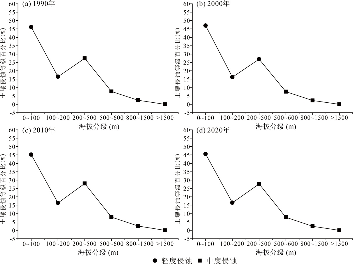
图13 1990—2020年不同海拔土壤侵蚀占比
Fig.13 Proportion of soil erosion at different altitudes from 1990 to 2020
| [1] | 王礼先, 朱金兆. 水土保持学[M]. 2版. 北京: 中国林业出版社, 2005. |
| [2] | BORRELLI P, ROBINSON D A, FLEISCHER L R, et al. An assessment of the global impact of 21st century land use change on soil erosion[J]. Nature Communications, 2017, 8(1): 2013. |
| [3] | MARTÍN-FERNÁNDEZ L, MARTÍNEZ-NÚÑEZ M. An empirical approach to estimate soil erosion risk in Spain[J]. Science of the Total Environment, 2011, 409(17): 3114-3123. |
| [4] | MOAYEDI H, NAZIR R, FOONG L K, et al. A review on soil erosion control studies[M]// Advances in Remote Sensing and Geo Informatics Applications. Cham: Springer International Publishing, 2018: 211-213. |
| [5] | FLANAGAN D C, ASCOUGH J C, NIEBER J L, et al. Advances in soil erosion research: Processes, measurement, and modeling[J]. Transactions of the ASABE, 2013, 56(2): 455-463. |
| [6] | PIMENTEL D. Soil erosion: A food and environmental threat[J]. Environment, Development and Sustainability, 2006, 8(1): 119-137. |
| [7] | ZHAO W W, WEI H, JIA L Z, et al. Soil erodibility and its influencing factors on the Loess Plateau of China: A case study in the Ansai watershed[J]. Solid Earth, 2018, 9(6): 1507-1516. |
| [8] |
BORRELLI P, BALLABIO C, YANG J E, et al. GloSEM: High-resolution global estimates of present and future soil displacement in croplands by water erosion[J]. Scientific Data, 2022, 9(1): 406.
DOI PMID |
| [9] | WISCHMEIER W H, SMITH D. Predicting rainfall erosion losses: A guide to conservation planning[M]. United States Department of Agriculture.Agriculture Handbook (USA), 1978. |
| [10] | LIU B Y, ZHANG K L, XIE Y. An empirical soil loss equation[C]. Proceedings 12th International Soil Conservation Organization Conference. Beijing, 2002. |
| [11] | HATEFFARD F, MOHAMMED S, ALSAFADI K, et al. CMIP5 climate projections and RUSLE-based soil erosion assessment in the central part of Iran[J]. Scientific Reports, 2021, 11(1):72-73. |
| [12] | 陈浩, 张晓萍, 王豆豆, 等. 北洛河上游流域土壤侵蚀变化及影响因素分析[J]. 中国水土保持科学(中英文), 2023, 21(2): 64-73. |
| [13] | 管礼松. 基于CSLE模型的皖南山区土壤侵蚀评价及预测研究[D]. 淮南: 安徽理工大学, 2021. |
| [14] | FU B J, LIU Y, LÜ Y H, et al. Assessing the soil erosion control service of ecosystems change in the Loess Plateau of China[J]. Ecological Complexity, 2011, 8(4): 284-293. |
| [15] | FU B J, WANG S, LIU Y, et al. Hydrogeomorphic ecosystem responses to natural and anthropogenic changes in theLoess Plateau of China[J]. Annual Review of Earth and Planetary Sciences, 2017, 45: 223-243. |
| [16] |
GAO H D, LI Z B, JIA L L, et al. Capacity of soil loss control in the Loess Plateau based on soil erosion control degree[J]. Journal of Geographical Sciences, 2016, 26(4): 457-472.
DOI |
| [17] | LIU J N, QI X Q, MA C Y, et al. Response of sheet erosion to the characteristics of physical soil crusts for loessial soils[J]. Frontiers in Environmental Science, 2022, 10: 905045. |
| [18] | LIU G, LIU P L, ZHANG Q, et al. Assessment of soil erosion risk based on loess deposition rate[C]. Asia-Pacific Power and Energy Engineering Conference. 2011,25-28. |
| [19] | ZHAO G, MU X, WEN Z, et al. Soil erosion, conservation, and eco-environment changes in the Loess Plateau of China[J]. Land Degradation & Development, 2013, 24(5): 499-510. |
| [20] | LI P F, MU X M, HOLDEN J, et al. Comparison of soil erosion models used to study the Chinese Loess Plateau[J]. Earth-Science Reviews, 2017, 170: 17-30. |
| [21] | 陈思旭, 杨小唤, 肖林林, 等. 基于RUSLE模型的南方丘陵山区土壤侵蚀研究[J]. 资源科学, 2014, 36(6): 1288-1297. |
| [22] | 陈龙, 谢高地, 张昌顺, 等. 澜沧江流域土壤侵蚀的空间分布特征[J]. 资源科学, 2012, 34(7): 1240-1247. |
| [23] | 陈燕红, 潘文斌, 蔡芫镔. 基于RUSLE的流域土壤侵蚀敏感性评价: 以福建省吉溪流域为例[J]. 山地学报, 2007, 25(4): 490-496. |
| [24] | LIU B Y, XIE Y, LI Z G, et al. The assessment of soil loss by water erosion in China[J]. International Soil and Water Conservation Research, 2020, 8(4): 430-439. |
| [25] | 刘宝元, 郭索彦, 李智广, 等. 中国水力侵蚀抽样调查[J]. 中国水土保持, 2013(10): 26-34. |
| [26] | 周伏建, 陈明华, 林福兴. 福建省降雨侵蚀力指标R值[J]. 中国水土保持, 1995, 9(3): 13-18. |
| [27] | 刘宝元, 张科利, 焦菊英. 土壤可蚀性及其在侵蚀预报中的应用[J]. 自然资源学报, 1999, 14(4): 345-350. |
| [28] | HUANG X F, LIN L R, DING S W, et al. Characteristics of soil erodibility K value and its influencing factors in theChangyan watershed, southwest Hubei, China[J]. Land, 2022, 11(1): 134. |
| [29] | 张科利, 彭文英, 杨红丽. 中国土壤可蚀性值及其估算[J]. 土壤学报, 2007, 44(1): 7-13. |
| [30] | 环境保护部, 国家发展改革委. .生态保护红线划定指南[R]. 环境保护部, 国家发展改革委, 2017. |
| [31] | 高峰. 基于GIS和CSLE的区域土壤侵蚀定量评价研究[D]. 南宁: 广西师范学院, 2014. |
| [32] | 蔡崇法, 丁树文, 史志华, 等. 应用USLE模型与地理信息系统IDRISI预测小流域土壤侵蚀量的研究[J]. 水土保持学报, 2000(2): 19-24. |
| [33] | 张岩, 刘宝元, 史培军, 等. 黄土高原土壤侵蚀作物覆盖因子计算[J]. 生态学报, 2001, 21(7) : 1050-1056. |
| [34] | 程琳, 杨勤科, 谢红霞, 等. 基于GIS和CSLE的陕西省土壤侵蚀定量评价方法研究[J]. 水土保持学报, 2009, 23(5): 61-66. |
| [35] | 谢红霞. 延河流域土壤侵蚀时空变化及水土保持环境效应评价研究[D]. 西安: 陕西师范大学, 2008. |
| [36] | 曹文洪. 土壤侵蚀的坡度界限研究[J]. 水土保持通报, 1993, 13(4): 1-5. |
| [37] |
靳长兴. 论坡面侵蚀的临界坡度[J]. 地理学报, 1995, 50(3): 234-239.
DOI |
| [38] | 孙泽祥. 基于GIS和RS的沂河上游重点地区土壤侵蚀监测方法研究[D]. 济南: 山东师范大学, 2012. |
| [39] | 韩帅, 孙萍, 李荣建, 等. 甘肃天水地区强降雨诱发黄土-泥岩滑坡机理实验研究[J]. 现代地质, 2021, 35(3): 720-731. |
| [40] | 张卢明, 杨东, 周勇, 等. 震后深切拉槽型泥石流成因模式、暴发特点与防治: 以四川九寨沟牙扎沟为例[J]. 现代地质, 2021, 35(3): 744-752. |
| [41] | 管礼松, 郭伟玲, 李鑫, 等. 2000—2018年皖南山区土壤侵蚀时空变化[J]. 水土保持通报, 2021, 41(2): 114-121. |
| [42] | 魏总, 杨朝磊, 田瑜峰, 等. 金沙江干热河谷区土壤侵蚀时空演变及其定量归因分析: 以云南楚雄元谋地区为例[J]. 现代地质, 2024, 38(3): 683-693. |
| [1] | 李志恒, 刘晓煌, 夏学齐, 肖粤新, 张文博, 王然, 雒新萍, 邢莉圆. 1990—2020年华北平原耕地区土壤侵蚀强度时空演变及驱动力分析[J]. 现代地质, 2025, 39(02): 467-476. |
| [2] | 魏总, 杨朝磊, 田瑜峰, 杨金江, 黄勇, 和峰, 朱志平. 金沙江干热河谷区土壤侵蚀时空演变及其定量归因分析:以云南楚雄元谋地区为例[J]. 现代地质, 2024, 38(03): 683-693. |
| [3] | 闵婕, 刘晓煌, 肖粤新, 李洪宇, 雒新萍, 王然, 邢莉圆, 王超, 赵宏慧. 基于PLUS模型和InVEST模型的新安江流域生态系统碳储量时空变化分析与预测[J]. 现代地质, 2024, 38(03): 574-588. |
| [4] | 李春亮, 王翔, 张炜, 曲正钢, 杨菁, 张君. 黄土高原西段表层土壤有机碳储量及时空变化规律[J]. 现代地质, 2022, 36(02): 655-661. |
| [5] | 董秋瑶, 温皓天, 宋超, 杨振京, 严明疆. 河南南阳盆地东南耕区表层土壤养分地球化学综合评价及影响因素[J]. 现代地质, 2022, 36(02): 449-461. |
| [6] | 刘国栋, 戴慧敏, 杨泽, 许江, 张一鹤, 魏明辉. 三江平原土壤碳库时空变化和影响因素研究[J]. 现代地质, 2021, 35(02): 443-454. |
| [7] | 姜伟,侯青叶,杨忠芳,夏学齐,钟聪. 黑龙江省乌裕尔河流域有机碳迁移与沉积通量[J]. 现代地质, 2011, 25(2): 377-383. |
| 阅读次数 | ||||||
|
全文 |
|
|||||
|
摘要 |
|
|||||