

现代地质 ›› 2024, Vol. 38 ›› Issue (02): 437-450.DOI: 10.19657/j.geoscience.1000-8527.2023.067
麻晟( ), 陈剑(), 吴赛儿
收稿日期:2023-03-22
修回日期:2023-06-16
出版日期:2024-04-10
发布日期:2024-05-22
通讯作者:
陈 剑,男,教授,1975年出生,地质工程专业,主要从事地质灾害与工程地质研究。Email: jianchen@cugb.edu.cn。
作者简介:麻 晟,男,硕士研究生,2000年出生,地质工程专业,主要从事地质灾害与工程地质研究。Email: 2631144090@qq.com。
基金资助:
MA Sheng(), CHEN Jian(), WU Sai’er
Received:2023-03-22
Revised:2023-06-16
Online:2024-04-10
Published:2024-05-22
摘要:
开展滑坡易发性评价是防灾减灾工作的基础科学前提。陕西省安康市汉滨区是滑坡灾害多发区,为研究滑坡提供了良好的窗口。本文以汉滨区瀛湖镇为典例,综合选取高程、地形起伏度、斜坡结构、坡向、高程变异系数、覆盖层厚度、坡度、归一化植被系数 (NDVI)、距道路距离和距河流距离等10项影响因子,以斜坡单元为评价依据,采用频率比 (FR)分析了滑坡分布特征。进一步基于逻辑回归-频率比组合法 (LR-FR)开展研究区的滑坡易发性评价,并对结果进行检验与分析。结果显示高程变异系数、地形起伏度、坡向和距道路距离为研究区影响滑坡发育的主控因子;LR-FR的成功率和预测率分别为0.804、0.843;极高易发区与高易发区主要分布在瀛湖水库两岸以及道路和河流附近,两区占斜坡总面积的33.66%,其中滑坡发育面积为1.08 km2,占滑坡总面积的84.36%,与实际滑坡的分布具有良好的一致性,表明易发性评价结果可靠。研究成果为汉滨区瀛湖镇地质灾害风险管控以及类似地区滑坡易发性评价研究工作提供了新的基础参考依据。
中图分类号:
麻晟, 陈剑, 吴赛儿. 陕西省安康市瀛湖镇滑坡灾害分布特征与易发性分析[J]. 现代地质, 2024, 38(02): 437-450.
MA Sheng, CHEN Jian, WU Sai’er. Distribution Characteristics and Susceptibility Assessment of Landslide Hazards in Yinghu Town, Ankang, Shaanxi[J]. Geoscience, 2024, 38(02): 437-450.
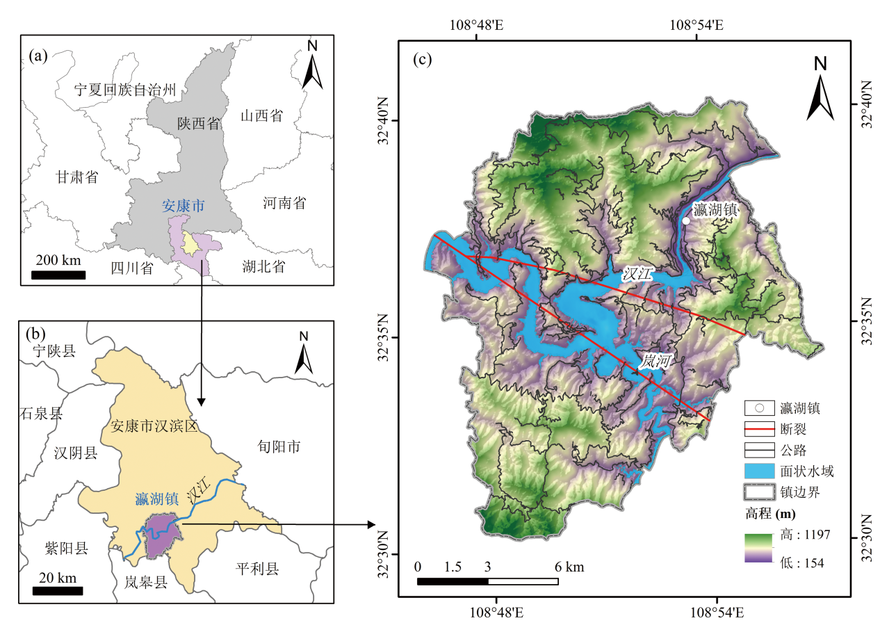
图1 瀛湖镇位置(a)(b)与地理和地质概况(c)
Fig.1 Location of the Yinghu Town (a)(b) and geographic and geologic profile (c)
| 数据集 | 分辨率 | 数据用途 |
|---|---|---|
| DEM | 30 m | 高程等地形因子、 水系和斜坡单元提取 |
| Sentinel-2影像 2022/03/09 | 10 m、20 m和 60 m | 归一化植被系数 (NDVI)提取 |
| 道路 | — | 距道路距离因子获取 |
表1 瀛湖镇易发性评价数据源
Table 1 Data sources of the susceptibility assessment in Yinghu Town
| 数据集 | 分辨率 | 数据用途 |
|---|---|---|
| DEM | 30 m | 高程等地形因子、 水系和斜坡单元提取 |
| Sentinel-2影像 2022/03/09 | 10 m、20 m和 60 m | 归一化植被系数 (NDVI)提取 |
| 道路 | — | 距道路距离因子获取 |
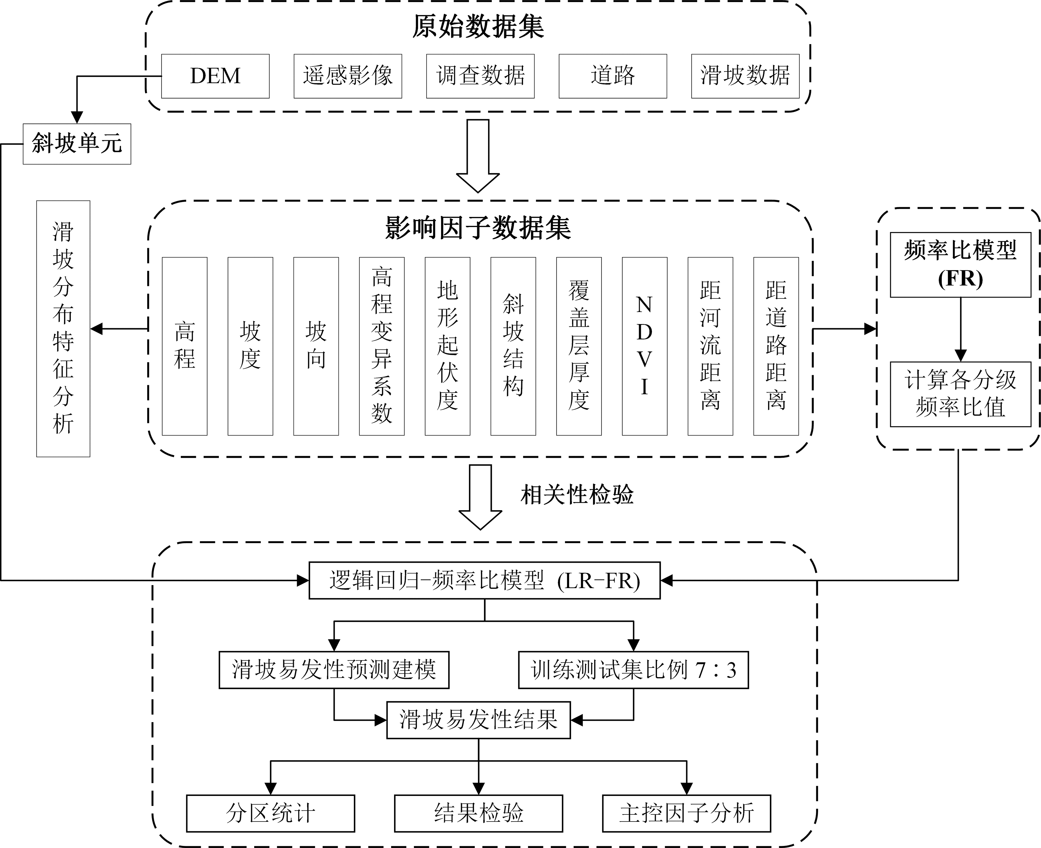
图2 瀛湖镇滑坡易发性评价技术路线
Fig.2 Technical route of the landslide susceptibility assessment in Yinghu Town

图3 瀛湖镇水文分析法斜坡单元划分步骤(菱形框内文字表示数据,长方形框内文字表示操作)(据文献[21]修改)
Fig.3 Steps of slope unit division in hydrological analysis for Yinghu Town (Diamond boxes represent data, rectangular boxes represent operations) (modified after reference [21])

图4 瀛湖镇斜坡单元划分 (a) (b)与面积分布统计 (c)
Fig.4 Slope unit division (a) (b) and area distribution statistics (c) in Yinghu Town

图5 瀛湖镇滑坡影响因子图集 (a) 高程;(b) 地形起伏度;(c) 斜坡结构;(d) 坡向;(e) 高程变异系数;(f) 覆盖层厚度;(g) 坡度;(h) NDVI;(i) 距道路距离;(j) 距河流距离
Fig.5 Atlas of impact factors for landslides in Yinghu Town

图6 瀛湖镇滑坡分布
Fig.6 Landslide distribution in Yinghu Town

图7 瀛湖镇滑坡面积分布特征
Fig.7 Distribution characteristics of the landslide areas in Yinghu Town

图8 瀛湖镇滑坡照片 (a) 方家坡滑坡;(b)胡家田坝滑坡;(c) 朱家窝子滑坡;(d) 闫家山滑坡
Fig.8 Photos of the landslides in Yinghu Town
| 评价因子 | 分级 | 分级面积 (km2) | 滑坡面积 (km2) | 频率比 | 评价因子 | 分级 | 分级面积 (km2) | 滑坡面积 (km2) | 频率比 |
|---|---|---|---|---|---|---|---|---|---|
| 高程(m) | 285~413 | 37.03 | 0.44 | 1.60 | 覆盖层 厚度(m) | 2.90~4.10 | 83.83 | 0.59 | 0.95 |
| 413~510 | 44.26 | 0.52 | 1.59 | 4.10~4.70 | 48.29 | 0.39 | 1.09 | ||
| 510~623 | 45.22 | 0.13 | 0.40 | 4.70~5.10 | 16.88 | 0.18 | 1.41 | ||
| 623~762 | 33.08 | 0.16 | 0.66 | 5.10~7.62 | 12.49 | 0.08 | 0.81 | ||
| 762~1073 | 14.98 | 0.04 | 0.35 | 斜坡结构 | 顺向坡 | 30.32 | 0.32 | 1.42 | |
| 地形起 伏度(m) | 5~96 | 17.68 | 0.01 | 0.08 | 斜向坡 | 58.83 | 0.45 | 1.03 | |
| 96~155 | 41.49 | 0.32 | 1.05 | 横向坡 | 56.53 | 0.36 | 0.85 | ||
| 155~218 | 46.61 | 0.34 | 0.99 | 逆向坡 | 28.89 | 0.17 | 0.79 | ||
| 218~297 | 42.19 | 0.44 | 1.41 | 坡向 | 北 | 14.01 | 0.02 | 0.16 | |
| 297~450 | 26.61 | 0.18 | 0.90 | 东北 | 18.83 | 0.25 | 1.77 | ||
| 高程变 异系数 | 0.004~0.049 | 17.47 | 0.01 | 0.09 | 东 | 27.55 | 0.44 | 2.15 | |
| 0.049~0.078 | 45.57 | 0.08 | 0.25 | 东南 | 30.64 | 0.28 | 1.23 | ||
| 0.078~0.109 | 51.88 | 0.54 | 1.39 | 南 | 18.40 | 0.11 | 0.80 | ||
| 0.109~0.154 | 43.69 | 0.50 | 1.53 | 西南 | 22.15 | 0.07 | 0.45 | ||
| 0.154~0.248 | 15.85 | 0.17 | 1.42 | 西 | 21.88 | 0.09 | 0.57 | ||
| 坡度 (°) | 5~15 | 6.01 | 0.01 | 0.21 | 西北 | 21.10 | 0.04 | 0.24 | |
| 15~19 | 34.37 | 0.43 | 1.69 | 距道路 距离 (m) | 0~200 | 106.61 | 1.04 | 1.31 | |
| 19~23 | 64.68 | 0.52 | 1.08 | 200~400 | 44.18 | 0.25 | 0.77 | ||
| 23~27 | 52.98 | 0.25 | 0.62 | 400~600 | 16.50 | 0 | 0 | ||
| 27~38 | 16.51 | 0.09 | 0.73 | 600~800 | 5.83 | 0.01 | 0.14 | ||
| NDVI | 0.031~0.161 | 7.11 | 0.02 | 0.37 | >800 | 1.44 | 0 | 0 | |
| 0.161~0.183 | 34.29 | 0.16 | 0.62 | 距河流 距离 (m) | 0~200 | 77.58 | 0.82 | 1.42 | |
| 0.183~0.201 | 49.13 | 0.29 | 0.79 | 200~300 | 53.92 | 0.34 | 0.86 | ||
| 0.201~0.222 | 57.57 | 0.61 | 1.43 | 300~400 | 26.13 | 0.06 | 0.32 | ||
| 0.222~0.288 | 26.49 | 0.22 | 1.13 | 400~500 | 10.38 | 0 | 0.04 | ||
| 覆盖层 厚度 (m) | 0.99~2.90 | 13.08 | 0.07 | 0.69 | >500 | 6.57 | 0.07 | 1.45 |
表2 瀛湖镇滑坡影响因子分级及频率比计算统计
Table 2 Impact factor grading and frequency ratio calculation statistics for landslides in Yinghu Town
| 评价因子 | 分级 | 分级面积 (km2) | 滑坡面积 (km2) | 频率比 | 评价因子 | 分级 | 分级面积 (km2) | 滑坡面积 (km2) | 频率比 |
|---|---|---|---|---|---|---|---|---|---|
| 高程(m) | 285~413 | 37.03 | 0.44 | 1.60 | 覆盖层 厚度(m) | 2.90~4.10 | 83.83 | 0.59 | 0.95 |
| 413~510 | 44.26 | 0.52 | 1.59 | 4.10~4.70 | 48.29 | 0.39 | 1.09 | ||
| 510~623 | 45.22 | 0.13 | 0.40 | 4.70~5.10 | 16.88 | 0.18 | 1.41 | ||
| 623~762 | 33.08 | 0.16 | 0.66 | 5.10~7.62 | 12.49 | 0.08 | 0.81 | ||
| 762~1073 | 14.98 | 0.04 | 0.35 | 斜坡结构 | 顺向坡 | 30.32 | 0.32 | 1.42 | |
| 地形起 伏度(m) | 5~96 | 17.68 | 0.01 | 0.08 | 斜向坡 | 58.83 | 0.45 | 1.03 | |
| 96~155 | 41.49 | 0.32 | 1.05 | 横向坡 | 56.53 | 0.36 | 0.85 | ||
| 155~218 | 46.61 | 0.34 | 0.99 | 逆向坡 | 28.89 | 0.17 | 0.79 | ||
| 218~297 | 42.19 | 0.44 | 1.41 | 坡向 | 北 | 14.01 | 0.02 | 0.16 | |
| 297~450 | 26.61 | 0.18 | 0.90 | 东北 | 18.83 | 0.25 | 1.77 | ||
| 高程变 异系数 | 0.004~0.049 | 17.47 | 0.01 | 0.09 | 东 | 27.55 | 0.44 | 2.15 | |
| 0.049~0.078 | 45.57 | 0.08 | 0.25 | 东南 | 30.64 | 0.28 | 1.23 | ||
| 0.078~0.109 | 51.88 | 0.54 | 1.39 | 南 | 18.40 | 0.11 | 0.80 | ||
| 0.109~0.154 | 43.69 | 0.50 | 1.53 | 西南 | 22.15 | 0.07 | 0.45 | ||
| 0.154~0.248 | 15.85 | 0.17 | 1.42 | 西 | 21.88 | 0.09 | 0.57 | ||
| 坡度 (°) | 5~15 | 6.01 | 0.01 | 0.21 | 西北 | 21.10 | 0.04 | 0.24 | |
| 15~19 | 34.37 | 0.43 | 1.69 | 距道路 距离 (m) | 0~200 | 106.61 | 1.04 | 1.31 | |
| 19~23 | 64.68 | 0.52 | 1.08 | 200~400 | 44.18 | 0.25 | 0.77 | ||
| 23~27 | 52.98 | 0.25 | 0.62 | 400~600 | 16.50 | 0 | 0 | ||
| 27~38 | 16.51 | 0.09 | 0.73 | 600~800 | 5.83 | 0.01 | 0.14 | ||
| NDVI | 0.031~0.161 | 7.11 | 0.02 | 0.37 | >800 | 1.44 | 0 | 0 | |
| 0.161~0.183 | 34.29 | 0.16 | 0.62 | 距河流 距离 (m) | 0~200 | 77.58 | 0.82 | 1.42 | |
| 0.183~0.201 | 49.13 | 0.29 | 0.79 | 200~300 | 53.92 | 0.34 | 0.86 | ||
| 0.201~0.222 | 57.57 | 0.61 | 1.43 | 300~400 | 26.13 | 0.06 | 0.32 | ||
| 0.222~0.288 | 26.49 | 0.22 | 1.13 | 400~500 | 10.38 | 0 | 0.04 | ||
| 覆盖层 厚度 (m) | 0.99~2.90 | 13.08 | 0.07 | 0.69 | >500 | 6.57 | 0.07 | 1.45 |

图9 瀛湖镇滑坡影响因子分区与滑坡分布关系图 (a) 高程;(b)地形起伏度;(c)高程变异系数;(d)坡度;(e) NDVI;(f) 覆盖层厚度;(g) 坡向;(h) 斜坡结构;(i) 距道路距离;(j) 距河流距离。PoA. 因子分区面积与总面积比值;PoLA. 因子分区内滑坡发育面积与总滑坡面积比值;FR. 频率比
Fig.9 Relationship between impact factor zoning for landslides and landslide distribution in Yinghu Town
| 斜坡结构类型 | |Q-C| | 斜坡数量(个) |
|---|---|---|
| 顺向坡 | 0°~30° | 273 |
| 斜向坡 | 30°~60°、120°~150° | 541 |
| 横向坡 | 60°~120° | 529 |
| 逆向坡 | 120°~180° | 251 |
表3 瀛湖镇斜坡结构划分依据与数量统计(据文献[24]修改)
Table 3 Classification of slope structure types and quantitative statistics in Yinghu Town (modified after reference[24])
| 斜坡结构类型 | |Q-C| | 斜坡数量(个) |
|---|---|---|
| 顺向坡 | 0°~30° | 273 |
| 斜向坡 | 30°~60°、120°~150° | 541 |
| 横向坡 | 60°~120° | 529 |
| 逆向坡 | 120°~180° | 251 |
| 影响因子 | 斜坡结构 | 坡度 | 地形起伏度 | 高程 | 坡向 | NDVI | 距道路距离 | 距河流距离 | 高程变异系数 | 覆盖层厚度 |
|---|---|---|---|---|---|---|---|---|---|---|
| 斜坡结构 | 1.000 | |||||||||
| 坡度 | 0.155 | 1.000 | ||||||||
| 地形起伏度 | -0.210 | 0.183 | 1.000 | |||||||
| 高程 | -0.005 | -0.072 | -0.075 | 1.000 | ||||||
| 坡向 | 0.011 | 0.317 | 0.308 | 0.066 | 1.000 | |||||
| NDVI | -0.202 | 0.213 | 0.008 | -0.041 | -0.008 | 1.000 | ||||
| 距道路距离 | 0.193 | 0.215 | 0.084 | 0.068 | -0.005 | 0.224 | 1.000 | |||
| 距河流距离 | -0.153 | -0.004 | -0.036 | 0.516* | 0.021 | -0.023 | -0.040 | 1.000 | ||
| 高程变异系数 | -0.036 | 0.078 | 0.495 | 0.035 | 0.230 | 0.112 | 0.071 | 0.059 | 1.000 | |
| 覆盖层厚度 | -0.239 | -0.269 | 0.214 | -0.085 | 0.017 | 0.327 | -0.053 | -0.099 | 0.111 | 1.000 |
表4 瀛湖镇滑坡影响因子皮尔逊相关系数矩阵
Table 4 Pearson’s correlation matrix of the susceptibility impact factors for landslides in Yinghu Town
| 影响因子 | 斜坡结构 | 坡度 | 地形起伏度 | 高程 | 坡向 | NDVI | 距道路距离 | 距河流距离 | 高程变异系数 | 覆盖层厚度 |
|---|---|---|---|---|---|---|---|---|---|---|
| 斜坡结构 | 1.000 | |||||||||
| 坡度 | 0.155 | 1.000 | ||||||||
| 地形起伏度 | -0.210 | 0.183 | 1.000 | |||||||
| 高程 | -0.005 | -0.072 | -0.075 | 1.000 | ||||||
| 坡向 | 0.011 | 0.317 | 0.308 | 0.066 | 1.000 | |||||
| NDVI | -0.202 | 0.213 | 0.008 | -0.041 | -0.008 | 1.000 | ||||
| 距道路距离 | 0.193 | 0.215 | 0.084 | 0.068 | -0.005 | 0.224 | 1.000 | |||
| 距河流距离 | -0.153 | -0.004 | -0.036 | 0.516* | 0.021 | -0.023 | -0.040 | 1.000 | ||
| 高程变异系数 | -0.036 | 0.078 | 0.495 | 0.035 | 0.230 | 0.112 | 0.071 | 0.059 | 1.000 | |
| 覆盖层厚度 | -0.239 | -0.269 | 0.214 | -0.085 | 0.017 | 0.327 | -0.053 | -0.099 | 0.111 | 1.000 |
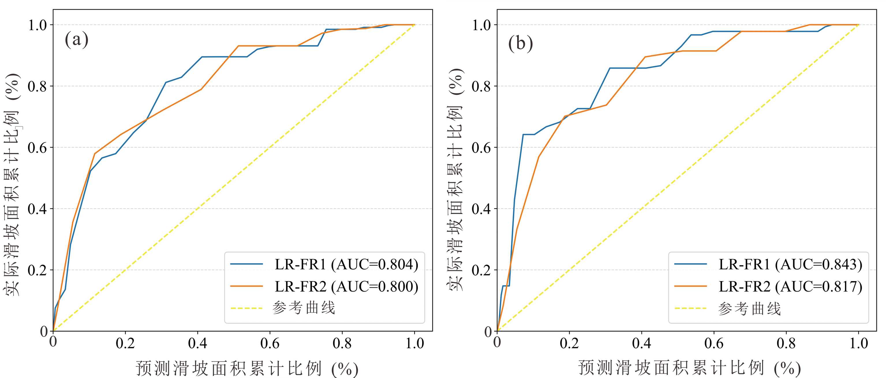
图10 瀛湖镇LR-FR模型ROC曲线 (a) 拟合曲线;(b) 预测曲线。LR-FR1指剔除高程的因子组合;LR-FR2指剔除距河流距离的因子组合;AUC为ROC曲线下面积
Fig.10 ROC curves of the LR-FR model in Yinghu Town
| 易发性 等级 | 分区面积 (km2) | 分区面积 占比(%) | 分区滑坡 面积(km2) | 滑坡面积 占比(%) | 频率 比 |
|---|---|---|---|---|---|
| 极高易发区 | 20.61 | 11.81 | 0.73 | 56.64 | 4.80 |
| 高易发区 | 37.62 | 21.55 | 0.35 | 26.68 | 1.24 |
| 中易发区 | 56.60 | 32.42 | 0.15 | 11.23 | 0.35 |
| 低易发区 | 39.27 | 22.50 | 0.05 | 4.20 | 0.19 |
| 极低易发区 | 20.46 | 11.72 | 0.02 | 1.26 | 0.11 |
表5 瀛湖镇滑坡易发性统计
Table 5 Statistics of susceptibility of the landslide in Yinghu Town
| 易发性 等级 | 分区面积 (km2) | 分区面积 占比(%) | 分区滑坡 面积(km2) | 滑坡面积 占比(%) | 频率 比 |
|---|---|---|---|---|---|
| 极高易发区 | 20.61 | 11.81 | 0.73 | 56.64 | 4.80 |
| 高易发区 | 37.62 | 21.55 | 0.35 | 26.68 | 1.24 |
| 中易发区 | 56.60 | 32.42 | 0.15 | 11.23 | 0.35 |
| 低易发区 | 39.27 | 22.50 | 0.05 | 4.20 | 0.19 |
| 极低易发区 | 20.46 | 11.72 | 0.02 | 1.26 | 0.11 |

图11 瀛湖镇滑坡易发性分布 (a)(b)与分区统计 (c) PoA. 易发性分区面积与研究区总面积比值;PoLA. 易发性分区内滑坡发育面积与总滑坡面积比值;FR. 频率比
Fig.11 Distribution of landslide susceptibility (a) (b) and regional statistics of landslides (c) in Yinghu Town

图12 瀛湖镇滑坡影响因子重要性排序
Fig.12 Ranking of importance of the landslide impact factor in Yinghu Town
| [1] | 许强. 对滑坡监测预警相关问题的认识与思考[J]. 工程地质学报, 2020, 28(2): 360-374. |
| [2] | 张俊, 殷坤龙, 王佳佳, 等. 三峡库区万州区滑坡灾害易发性评价研究[J]. 岩石力学与工程学报, 2016, 35(2): 284-296. |
| [3] | 陈世轩. 区域滑坡易发性预测及典型单体滑坡风险评价研究[D]. 南昌: 南昌大学, 2022. |
| [4] | 王伟, 陈帆, 金涛. 安康市汉滨区地质灾害发育成因及评价[J]. 陕西地质, 2020, 38(1): 71-78. |
| [5] | 刘增源. 安康市汉滨区滑坡敏感性评价研究[D]. 西安: 西安科技大学, 2021. |
| [6] | GUZZETTI F, REICHENBACH P, CARDINALI M, et al. Pro-babilistic landslide hazard assessment at the basin scale[J]. Geomorphology, 2005, 72(1/2/3/4): 272-299. |
| [7] | GUZZETTI F, CARRARA A, CARDINALI M, et al. Landslide hazard evaluation: A review of current techniques and their application in a multi-scale study, Central Italy[J]. Geomorphology, 1999, 31(1/2/3/4): 181-216. |
| [8] | 闫怡秋, 杨志华, 张绪教, 等. 基于加权证据权模型的青藏高原东部巴塘断裂带滑坡易发性评价[J]. 现代地质, 2021, 35(1): 26-37. |
| [9] | MALAMUD B D, TURCOTTE D L, GUZZETTI F, et al. Landslide inventories and their statistical properties[J]. Earth Surface Processes and Landforms, 2004, 29(6): 687-711. |
| [10] | GUZZETTI F, MONDINI A C, CARDINALI M, et al. Landslide inventory maps: New tools for an old problem[J]. Earth-Science Reviews, 2012, 112(1/2): 42-66. |
| [11] | REICHENBACH P, ROSSI M, MALAMUD B D, et al. A review of statistically-based landslide susceptibility models[J]. Earth-Science Reviews, 2018, 180: 60-91. |
| [12] | 屈飞行, 张菁, 汤明高. 基于GIS的区域地质灾害危险性评价流程与关键问题探讨[J]. 西华师范大学学报(自然科学版), 2018, 39(4): 420-428. |
| [13] | 许冲, 戴福初, 徐素宁, 等. 基于逻辑回归模型的汶川地震滑坡危险性评价与检验[J]. 水文地质工程地质, 2013, 40(3): 98-104. |
| [14] | 李文彦, 王喜乐. 频率比与信息量模型在黄土沟壑区滑坡易发性评价中的应用与比较[J]. 自然灾害学报, 2020, 29(4): 213-220. |
| [15] | 王卫东, 刘攀, 龚陆. 基于支持向量机模型的四川省滑坡灾害易发性区划[J]. 铁道科学与工程学报, 2019, 16(5): 1194-1200. |
| [16] | 吴润泽, 胡旭东, 梅红波, 等. 基于随机森林的滑坡空间易发性评价:以三峡库区湖北段为例[J]. 地球科学, 2021, 46(1): 321-330. |
| [17] | 栗泽桐, 王涛, 周杨, 等. 基于信息量、逻辑回归及其耦合模型的滑坡易发性评估研究:以青海沙塘川流域为例[J]. 现代地质, 2019, 33(1): 235-245. |
| [18] | 李信, 薛桂澄, 夏南, 等. 基于CF、CF-LR和CF-AHP模型的国家热带雨林公园地质灾害易发性研究:以海南保亭为例[J]. 现代地质, 2023, 37(4): 1033-1043. |
| [19] | CHEN W, CHEN X, PENG J B, et al. Landslide susceptibility modeling based on ANFIS with teaching-learning-based optimization and Satin bowerbird optimizer[J]. Geoscience Frontiers, 2021, 12(1): 93-107. |
| [20] | 吴赛儿. 强震区泥石流易发性研究[D]. 北京: 中国地质大学(北京), 2018. |
| [21] |
颜阁, 梁收运, 赵红亮. 基于GIS的斜坡单元划分方法改进与实现[J]. 地理科学, 2017, 37(11): 1764-1770.
DOI |
| [22] | 马啸. 府谷县崩-滑地质灾害发育特征及其易发性评价[D]. 西安: 西安科技大学, 2021. |
| [23] | 陈晓利, 冉洪流, 祁生文. 1976年龙陵地震诱发滑坡的影响因子敏感性分析[J]. 北京大学学报(自然科学版), 2009, 45(1): 104-110. |
| [24] | 罗路广, 裴向军, 黄润秋. 强震山区地震滑坡发生概率研究:以九寨沟国家地质公园为例[J]. 岩石力学与工程学报, 2020, 39(10): 2079-2093. |
| [25] | 邱海军. 区域滑坡崩塌地质灾害特征分析及其易发性和危险性评价研究[D]. 西安: 西北大学, 2012. |
| [26] | 秦红富, 谈树成, 施旖奇, 等. 基于CF-LR组合模型的地质灾害易发性评价:以云南省宁洱哈尼族彝族自治县为例[J]. 人民长江, 2022, 53(7): 119-127. |
| [27] | 高华喜, 殷坤龙. 降雨与滑坡灾害相关性分析及预警预报阀值之探讨[J]. 岩土力学, 2007, 28(5): 1055-1060. |
| [28] | 常志璐, 黄发明, 蒋水华, 等. 基于多尺度分割方法的斜坡单元划分及滑坡易发性预测[J]. 工程科学与技术, 2023, 55(1): 184-195. |
| [29] | CHANG Z L, CATANI F, HUANG F M, et al. Landslide susceptibility prediction using slope unit-based machine learning models considering the heterogeneity of conditioning factors[J]. Journal of Rock Mechanics and Geotechnical Engineering, 2023, 15(5): 1127-1143. |
| [30] | CHEN Z, YE F, FU W X, et al. The influence of DEM spatial resolution on landslide susceptibility mapping in the Baxie River Basin, NW China[J]. Natural Hazards, 2020, 101(3): 853-877. |
| [31] | 黄发明, 陈佳武, 唐志鹏, 等. 不同空间分辨率和训练测试集比例下的滑坡易发性预测不确定性[J]. 岩石力学与工程学报, 2021, 40(6): 1155-1169. |
| [32] | 李军, 周成虎. 基于栅格GIS滑坡风险评价方法中格网大小选取分析[J]. 遥感学报, 2003, 7(2): 86-92, 161. |
| [33] | CHANG Z L, DU Z, ZHANG F, et al. Landslide susceptibility prediction based on remote sensing images and GIS: Comparisons of supervised and unsupervised machine learning models[J]. Remote Sensing, 2020, 12(3): 502. |
| [1] | 邱振东, 郭长宝, 吴瑞安, 简文星, 倪嘉伟, 张亚楠, 闫怡秋. 金沙江上游沙丁麦大型古滑坡发育特征与稳定性评价[J]. 现代地质, 2024, 38(02): 451-463. |
| [2] | 王德富, 李永鑫, 任娟, 范亚军, 刘立, 罗超. 联合无人机光学与机载LiDAR在高位滑坡要素识别中的应用:以川西汶川龙溪沟滑坡为例[J]. 现代地质, 2024, 38(02): 464-476. |
| [3] | 杨校辉, 朱鹏, 袁中夏, 张卫雄, 丁保艳. 甘肃舟曲牙豁口多级滑坡变形特征及复活机理[J]. 现代地质, 2023, 37(04): 1004-1012. |
| [4] | 李信, 薛桂澄, 夏南, 柳长柱, 杨永鹏, 马波. 基于CF、CF-LR和CF-AHP模型的国家热带雨林公园地质灾害易发性研究:以海南保亭为例[J]. 现代地质, 2023, 37(04): 1033-1043. |
| [5] | 周洪福, 方甜, 夏晨皓, 冉涛, 徐如阁, 张景华. 工程扰动诱发川西杜米滑坡复活变形特征及机理分析[J]. 现代地质, 2023, 37(04): 1044-1053. |
| [6] | 田社权. 遥感综合地质解译方法在中尼铁路勘察中的应用研究[J]. 现代地质, 2023, 37(04): 1054-1064. |
| [7] | 曾帅, 马志刚, 赵聪, 杨磊, 张肃, 董继红, 梁京涛, 鄢圣武. 青藏高原东部大渡河流域太平桥乡古滑坡群复活特征多源遥感识别[J]. 现代地质, 2023, 37(04): 994-1003. |
| [8] | 马俊学, 陈剑, 崔之久, 刘蓓蓓. 基于HEC-RAS及GIS的川西叠溪古滑坡堰塞湖溃决洪水重建[J]. 现代地质, 2022, 36(02): 610-623. |
| [9] | 韩帅, 孙萍, 李荣建, 张瑾, 李晓斌, 祝恩珍. 甘肃天水地区强降雨诱发黄土-泥岩滑坡机理实验研究[J]. 现代地质, 2021, 35(03): 720-731. |
| [10] | 王浩杰, 孙萍, 韩帅, 张帅, 李晓斌, 王涛, 辛鹏, 郭强. 甘肃通渭“9·14”常河滑坡成因机理[J]. 现代地质, 2021, 35(03): 732-743. |
| [11] | 王家柱, 高延超, 冉涛, 铁永波, 张凡. 川藏铁路交通廊道某大型古滑坡成因及失稳模式分析[J]. 现代地质, 2021, 35(01): 18-25. |
| [12] | 闫怡秋, 杨志华, 张绪教, 孟少伟, 郭长宝, 吴瑞安, 张怡颖. 基于加权证据权模型的青藏高原东部巴塘断裂带滑坡易发性评价[J]. 现代地质, 2021, 35(01): 26-37. |
| [13] | 李雪, 郭长宝, 杨志华, 廖维, 吴瑞安, 金继军, 何元宵. 金沙江断裂带雄巴巨型古滑坡发育特征与形成机理[J]. 现代地质, 2021, 35(01): 47-55. |
| [14] | 朱德明, 李鹏岳, 胡孝洪, 吴新明. 金沙江白格滑坡残留体稳定性分析与防治对策[J]. 现代地质, 2021, 35(01): 56-63. |
| [15] | 张佳佳, 高波, 刘建康, 陈龙, 黄海, 李杰. 基于SBAS-InSAR技术的川藏铁路澜沧江段滑坡隐患早期识别[J]. 现代地质, 2021, 35(01): 64-73. |
| 阅读次数 | ||||||
|
全文 |
|
|||||
|
摘要 |
|
|||||