欢迎访问现代地质!

现代地质 ›› 2021, Vol. 35 ›› Issue (03): 732-743.DOI: 10.19657/j.geoscience.1000-8527.2020.073

• 水资源与环境地质 • 上一篇    下一篇

甘肃通渭“9·14”常河滑坡成因机理

王浩杰1,2(), 孙萍1,2(), 韩帅1,2, 张帅1,2, 李晓斌3, 王涛1,2, 辛鹏1,2, 郭强4   

  1. 1.中国地质科学院地质力学研究所,北京 100081
    2.新构造运动与地质灾害重点实验室,北京 100081
    3.中国地质大学(北京) 工程技术学院,北京 100083
    4.西安理工大学 岩土工程研究所,陕西 西安 710048
  • 收稿日期:2020-03-02 修回日期:2020-09-10 出版日期:2021-06-23 发布日期:2021-06-24
  • 通讯作者: 孙萍
  • 作者简介:孙 萍,女,研究员,博士生导师,1978年出生,地质工程专业,从事地质灾害方面的研究工作。Email: sunpingcgs@foxmail.com
    王浩杰,男,博士研究生,1992年出生,地质工程专业,从事工程地质学研究。Email: wanghaojie9219@qq.com
  • 基金资助:
    国家自然科学基金项目(41472296);中国地质调查局地质调查项目(DD20190717)

Failure Mechanism of the Changhe Landslide on September 14, 2019 in Tongwei, Gansu

WANG Haojie1,2(), SUN Ping1,2(), HAN Shuai1,2, ZHANG Shuai1,2, LI Xiaobin3, WANG Tao1,2, XIN Peng1,2, GUO Qiang4   

  1. 1. Institute of Geomechanics, Chinese Academy of Geological Sciences, Beijing 100081, China
    2. Key Laboratory of Neotectonic Movement & Geohazard, Beijing 100081, China
    3. School of Engineering and Technology, China University of Geosciences, Beijing 100083, China
    4. Institute of Geotechnical Engineering, Xi’an University of Technology, Xi’an, Shaanxi 710048, China
  • Received:2020-03-02 Revised:2020-09-10 Online:2021-06-23 Published:2021-06-24
  • Contact: SUN Ping

摘要:

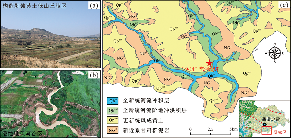
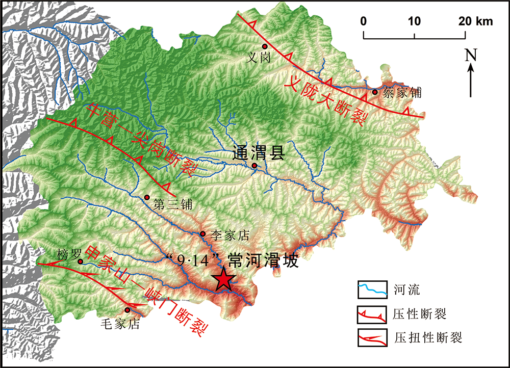
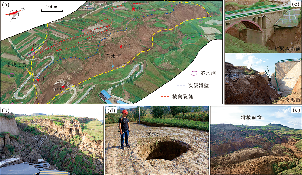
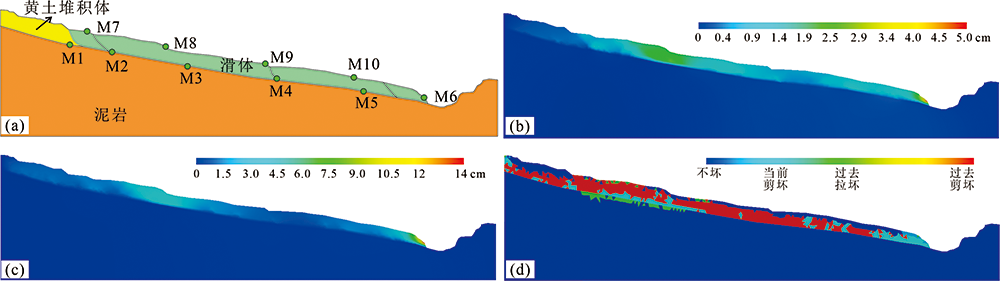
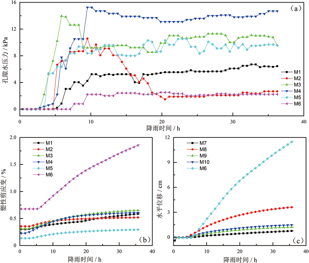
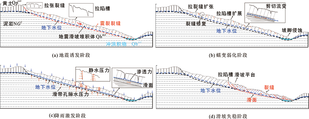
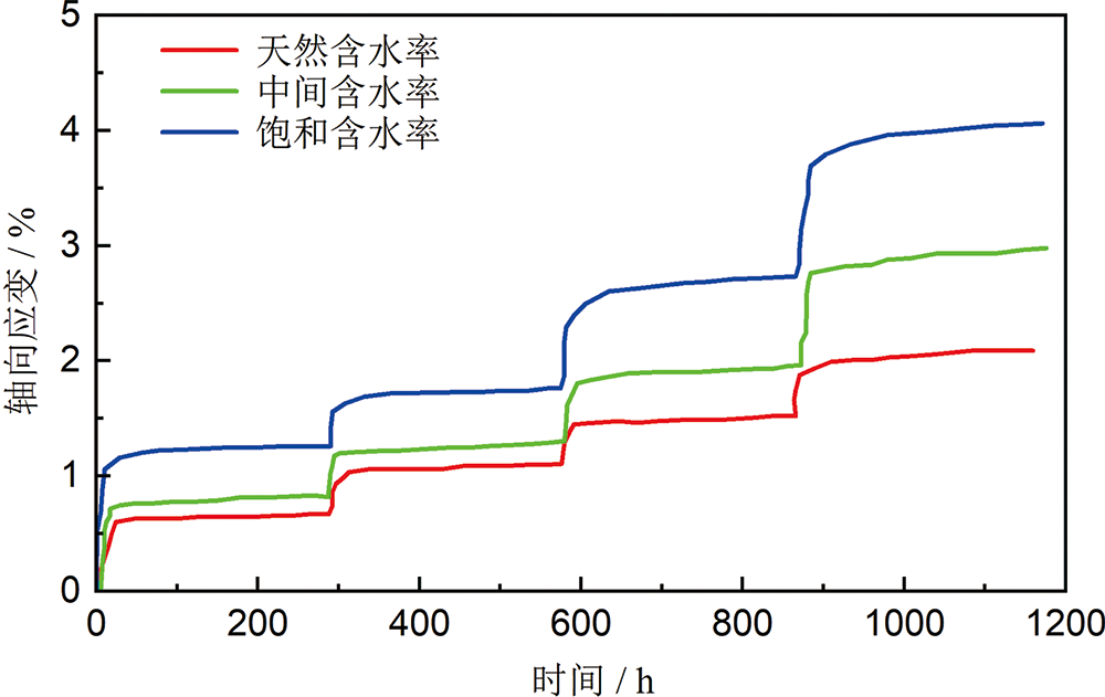
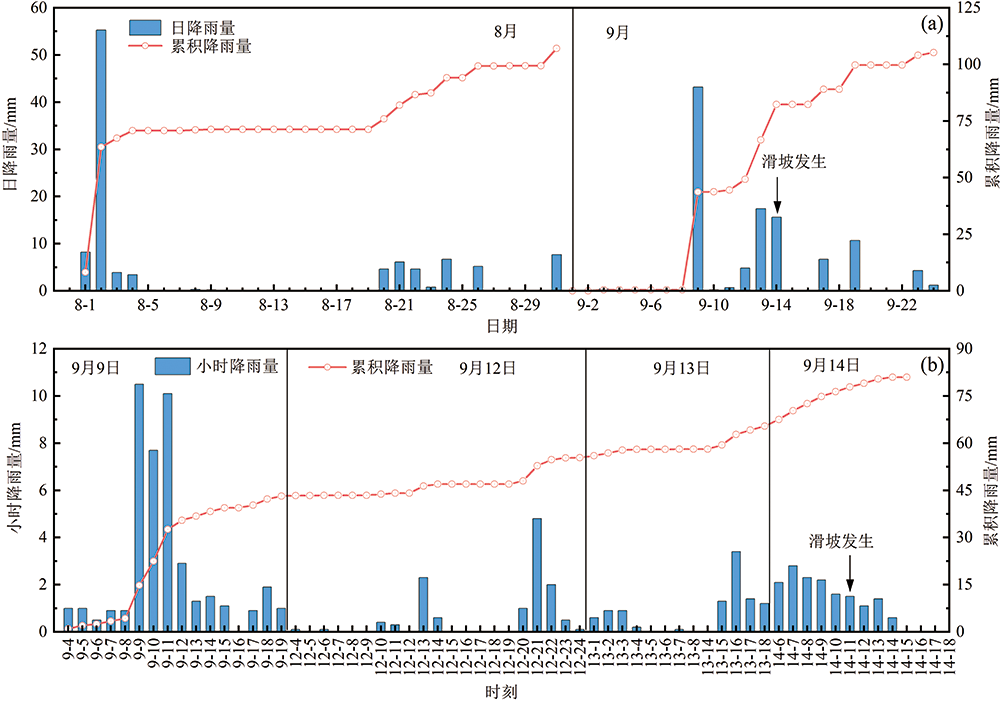
2019年9月14日11时,受多日降雨影响,甘肃省定西市通渭县常家河镇小庄村发生大规模黄土滑坡,体积约800万m3。滑坡造成部分农田、公路及阳坡大桥损毁,直接经济损失约2 347.2万元。在对滑坡现场进行大量地面调查的基础上,通过无人机航拍、现场测绘、走访调查和数值模拟等手段对滑坡的变形破坏特征进行了分析,并在此基础上探讨了其成因机制。结果表明:斜坡体是在震裂、蠕变、软化、水动力等多种条件下按照一定的先后顺序由稳态逐步演化至失稳;该滑坡的失稳演化过程和灾变机制可以概括为原始斜坡(黄土、泥岩二元层状结构)-地震触发(滑坡堆积体、坡体震裂损伤)-蠕变弱化(层间剪切带、裂缝和落水洞扩展)-降雨激发(滑带软化、泥化,水压力作用)-失稳滑动(滑面贯通)5个阶段;由于长期的蠕变和雨水的渗透冲蚀,坡体上的落水洞和地下暗河十分发育,且是控制本次滑坡边界的关键因素;滑坡后缘和前缘变形剧烈,中部变形相对稍弱,推断该滑坡为受地形及地下水作用控制明显的牵引-推移式复合滑坡。

关键词: 甘肃通渭, 黄土地区, 降雨滑坡, 地震滑坡复活, 成因机理

Abstract:

A large loess landslide occurred in Xiaozhuang Village (Tongwei, Gansu Province) at around 11:00 am on September 14, 2019. About 800×104 m3 of a historical sliding mass was reactivated by rainfall, and slipped down along a weak interface. The sliding mass destroyed several roads and the Yangpo bridge. Preliminary estimation of 2,975 people in one township and two villages of Tongwei County were affected, causing a direct economic loss of 23.47 million yuan in agriculture, water conservancy, power supply, and infrastructure. Based on site investigation, unmanned aerial vehicle photography and numerical simulation, the deformation and failure characteristics of this landslide are described in detail, and the failure mechanism are preliminarily assessed. The main factor that affected the slope stability is the post-seismic interaction of rainfall and creep, and the failure process comprise five stages: pre-earthquake, earthquake damage, creep weakening, rainfall triggering and final sliding. Sinkholes and underground rivers were well developed in the slope, and represent the key control of the landslide boundary. Strong deformation and failure occurred at the trailing and leading edges of the landslide, but the deformation in the middle was relatively weak. We infer that the landslide was a traction-movement composite one controlled by topography and ground water. Understanding the conditions and mechanism of the Changhe landslide is hugely important for the early identification and risk prevention of similar landslides in the loess region of northwestern China.

Key words: Tongwei, Gansu, loess region, rainfall-induced landslide, revival of seismic landslide, failuremechanism

中图分类号: