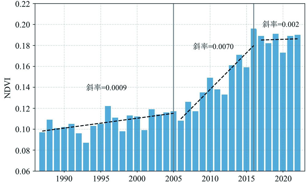
| [1] |
PIAO S L, WANG X H, CIAIS P, et al. Changes in satellite-derived vegetation growth trend in temperate and boreal Eurasia from 1982 to 2006[J]. Global Change Biology, 2011, 17(10): 3228-3239.
|
| [2] |
WANG J, WANG K L, ZHANG M Y, et al. Impacts of climate change and human activities on vegetation cover in hilly Southern China[J]. Ecological Engineering, 2015, 81: 451-461.
|
| [3] |
WANG C, HOU P, LIU X M, et al. Spatiotemporal changes in vegetation cover of the national key ecosystem protection and restoration project areas, China[J]. Acta Ecologica Sinica, 2023, 43(21): 8903-8916.
|
| [4] |
吴薇. 毛乌素沙地沙漠化过程及其整治对策[J]. 中国生态农业学报, 2001, 9(3): 15-18.
|
| [5] |
漆喜林. 陕西毛乌素沙地沙漠化治理现状及对策[J]. 陕西林业科技, 2002(3): 61-63.
|
| [6] |
吴薇. 近50年来毛乌素沙地的沙漠化过程研究[J]. 中国沙漠, 2001, 21(2): 164-169.
|
| [7] |
房世波, 许端阳, 张新时. 毛乌素沙地沙漠化过程及其气候因子驱动分析[J]. 中国沙漠, 2009, 29(5): 796-801.
|
| [8] |
WU B, CI L J. Landscape change and dese.pngication development in the Mu Us Sandland, Northern China[J]. Journal of Arid Environments, 2002, 50(3): 429-444.
|
| [9] |
ZENG L L, WARDLOW B D, XIANG D X, et al. A review of vegetation phenological metrics extraction using time-series, multispectral satellite data[J]. Remote Sensing of Environment, 2020, 237: 111511.
|
| [10] |
RIIHIMÄKI H, LUOTO M, HEISKANEN J. Estimating fractional cover of tundra vegetation at multiple scales using unmanned aerial systems and optical satellite data[J]. Remote Sensing of Environment, 2019, 224: 119-132.
|
| [11] |
陈震, 张耘实, 陈建平, 等. 基于分形特征的高标准农田遥感分类方法研究[J]. 现代地质, 2018, 32(3): 595-601.
|
| [12] |
安国英, 郭兆成, 叶佩. 云南大理地区1989—2019年期间气候变化及对洱海水质的影响[J]. 现代地质, 2022, 36(2): 406-417.
|
| [13] |
AKRITAS M G, MURPHY S A, LAVALLEY M P. The Theil-Sen estimator with doubly censored data and applications to astronomy[J]. Journal of the American Statistical Association, 1995, 90(429): 170-177.
|
| [14] |
王欣毅, 杨洁, 林良国, 等. 基于Sen+Mann-Kendall陕西省植被覆盖度时空变化规律研究[J]. 农业与技术, 2023, 43(7): 62-66.
|
| [15] |
赵耀华, 彭小清, 金浩东, 等. 基于多源遥感数据的青藏高原植被变化特征评价[J]. 冰川冻土, 2022, 44(4): 1216-1230.
DOI
|
| [16] |
汪东川, 陈星, 孙志超, 等. 格尔木长时间序列遥感生态指数变化监测[J]. 生态学报, 2022, 42(14): 5922-5933.
|
| [17] |
周紫燕, 汪小钦, 丁哲, 等. 新疆生态质量变化趋势遥感分析[J]. 生态学报, 2020, 40(9): 2907-2919.
|
| [18] |
GORELICK N, HANCHER M, DIXON M, et al. Google Earth Engine: Planetary-scale geospatial analysis for everyone[J]. Remote Sensing of Environment, 2017, 202: 18-27.
|
| [19] |
国家林业和草原局. “关于毛乌素沙地绿上加绿、提质增效的建议”复文[EB]. 2021, 第3308号.
|
| [20] |
SCHMIDT G, JENKERSON C, MASEK J, et al. Landsat ecosystem disturbance adaptive processing system (LEDAPS) algorithm description[R]. Washington: US Geological Survey Open-File Report, 2013, 17.
|
| [21] |
DWYER J L, ROY D P, SAUER B, et al. Analysis ready data: Enabling analysis of the landsat archive[J]. Remote Sensing, 2018, 10(9): 1363.
|
| [22] |
CHEN J, ZHU X L, VOGELMANN J E, et al. A simple and effective method for filling gaps in Landsat ETM+ SLC-off images[J]. Remote Sensing of Environment, 2011, 115(4): 1053-1064.
|
| [23] |
MUÑOZ S J. ERA5-Land monthly averaged data from 1981 to present[DB]. Copernicus Climate Change Service (C3S) Climate Data Store(CDS), 2019.
|
| [24] |
HOFFMANN L, GÜNTHER G, LI D, et al. From ERA-Interim to ERA5: The considerable impact of ECMWF’s next-generation reanalysis on Lagrangian transport simulations[J]. Atmospheric Chemistry and Physics, 2019, 19(5): 3097-3124.
|
| [25] |
JIANG Q, LI W Y, FAN Z D, et al. Evaluation of the ERA5 reanalysis precipitation dataset over Chinese Mainland[J]. Journal of Hydrology, 2021, 595: 125660.
|
| [26] |
XU B, QI B, JI K, et al. Emerging hot spot analysis and the spatial-temporal trends of NDVI in the Jing River Basin of China[J]. Environmental Earth Sciences, 2022, 81(2): 55.
|
| [27] |
GAO L, WANG X F, JOHNSON B A, et al. Remote sensing algorithms for estimation of fractional vegetation cover using pure vegetation index values: A review[J]. ISPRS Journal of Photogrammetry and Remote Sensing, 2020, 159: 364-377.
DOI
PMID
|
| [28] |
HUANG S, TANG L N, HUPY J P, et al. A commentary review on the use of normalized difference vegetation index (NDVI) in the era of popular remote sensing[J]. Journal of Forestry Research, 2021, 32(1): 1-6.
|
| [29] |
SUN L, LI H, WANG J, et al. Impacts of climate change and human activities on NDVI in the Qinghai-Tibet Plateau[J]. Remote Sensing, 2023, 15(3): 587.
|
| [30] |
龚斌, 万力, 胡伏生, 等. 沙漠绿洲变化的遥感监测方法[J]. 现代地质, 2005, 19(1): 152-156.
|
| [31] |
LEE T Y, KAUFMAN Y J. Non-lambertian effects on remote sensing of surface reflectance and vegetation index[J]. IEEE Transactions on Geoscience and Remote Sensing, 1986, GE-24(5): 699-708.
|
| [32] |
WANG L, JIA M M, YIN D M, et al. A review of remote sensing for mangrove forests: 1956-2018[J]. Remote Sensing of Environment, 2019, 231: 111223.
|
| [33] |
JIANG W G, YUAN L H, WANG W J, et al. Spatio-temporal analysis of vegetation variation in the Yellow River Basin[J]. Ecological Indicators, 2015, 51: 117-126.
|
| [34] |
LIU Z Z, WANG H, LI N, et al. Spatial and temporal characteristics and driving forces of vegetation changes in the Huaihe River Basin from 2003 to 2018[J]. Sustainability, 2020, 12(6): 2198.
|
| [35] |
HUSSAIN M, MAHMUD I. PyMannKendall: A python package for non parametric Mann Kendall family of trend tests[J]. Journal of Open Source Software, 2019, 4(39): 1556.
|
| [36] |
王佃来, 刘文萍, 黄心渊. 基于Sen+Mann-Kendall的北京植被变化趋势分析[J]. 计算机工程与应用, 2013, 49(5):13-17.
|
| [37] |
LEBRINI Y, BENABDELOUAHAB T, BOUDHAR A, et al. Farming systems monitoring using machine learning and trend analysis methods based on fitted NDVI time series data in a semi-arid region of Morocco[M]//Remote Sensing for Agriculture, Ecosystems, and HydrologyXXI. Strasbourg: SPLE, 2019.
|
| [38] |
HU J M, YE B Y, BAI Z K, et al. Remote sensing monitoring of vegetation reclamation in the antaibao open-pit mine[J]. Remote Sensing, 2022, 14(22): 5634.
|
| [39] |
ZHONG X Z, LI J, WANG J L, et al. Linear and nonlinear characteristics of long-term NDVI using trend analysis: A case study of lancang-mekong river basin[J]. Remote Sensing, 2022, 14(24): 6271.
|
| [40] |
中共中央国务院印发黄河流域生态保护和高质量发展规划纲要[J]. 自然资源通讯, 2021(19):17-35.
|
 ), KONG Xiangsheng4(