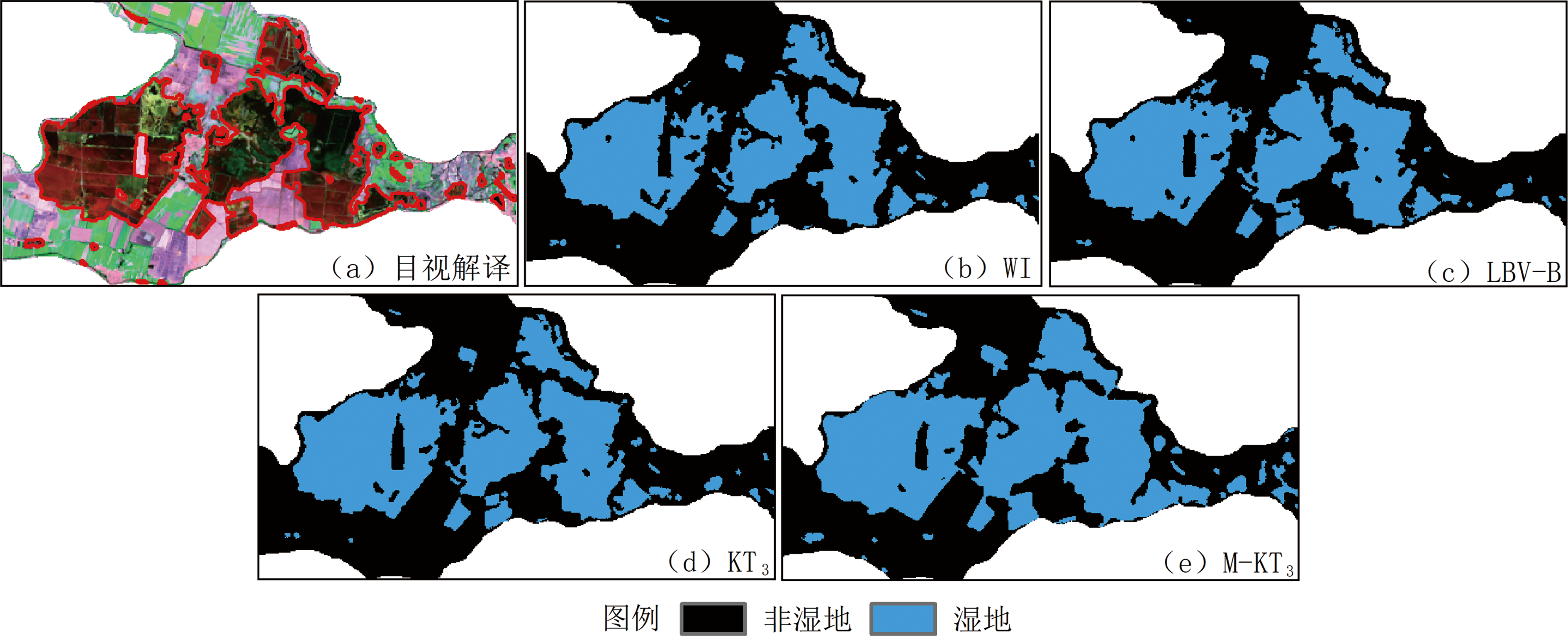
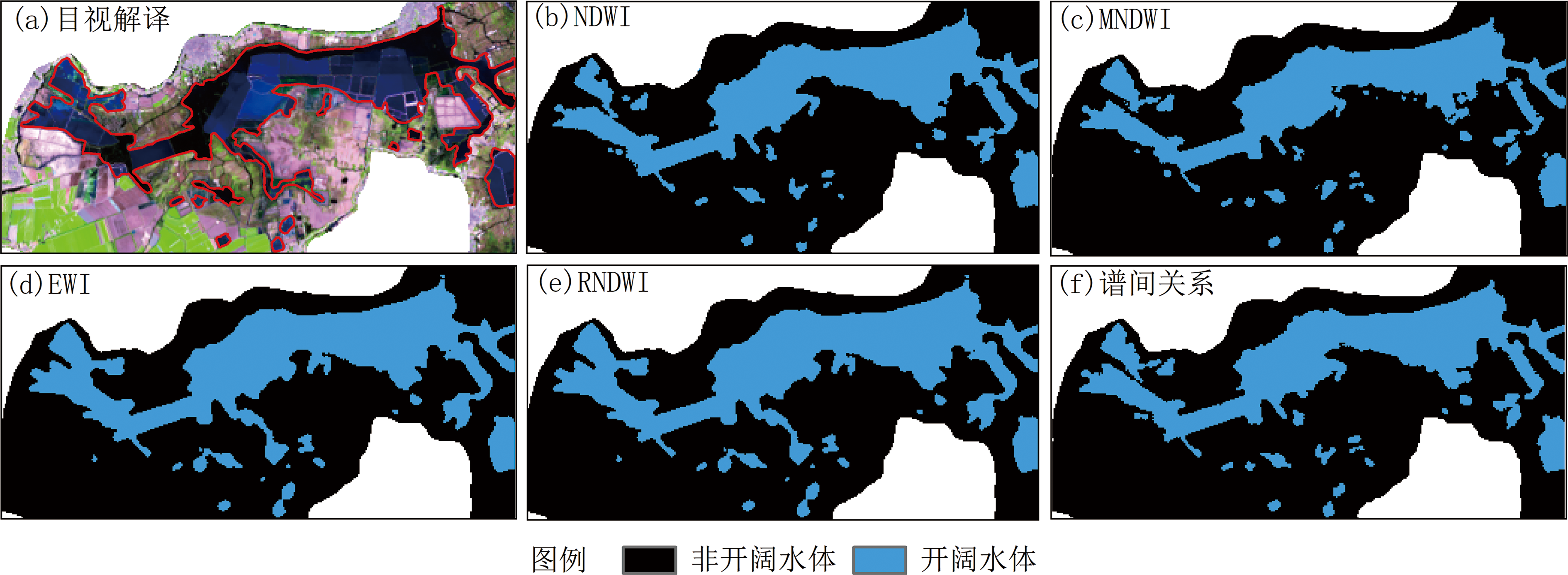
| [1] |
Office of International Standards and Legal Affairs, UNESCO. Convention on Wetlands of International Importance Especially as Waterfowl Habitat[EB/OL]. (1971-02-02)[2017-02-14].http://portal.unesco.org/en/ev.php-URL_ID=15398&URL_DO=DO_TOPIC&URL_SECTION=201.html.
|
| [2] |
金晓媚, 高萌萌, 柯珂, 等. 巴丹吉林沙漠湖泊遥感信息提取及动态变化趋势[J]. 科技导报, 2014, 32(8):15-21.
|
| [3] |
ASHRAF M, NAWAZ R. A comparison of change detection analyses using different band algebras for Baraila Wetland with Nasa’s multi-temporal Landsat Dataset[J]. Journal of Geographic Information System, 2015, 7(1):1-19.
DOI
URL
|
| [4] |
李博伦, 遆超普, 颜晓元. Landsat 8陆地成像仪影像的缨帽变换推导[J]. 测绘科学, 2016, 41(4):102-107.
|
| [5] |
ZENG Z Y. A new method of data transformation for satellite images: I. Methodology and transformation equations for TM images[J]. International Journal of Remote Sensing, 2007, 28(18):4095-4124.
DOI
URL
|
| [6] |
贾永红, 李芳芳. 一种新的湿地信息遥感提取方法研究[J]. 华中师范大学学报(自然科学版), 2007, 41(4):641-644.
|
| [7] |
MCFEETERS S K. The use of the Normalized Difference Water Index (NDWI) in the delineation of open water features[J]. International Journal of Remote Sensing, 1996, 17(7):1425-1432.
DOI
URL
|
| [8] |
徐涵秋. 利用改进的归一化差异水体指数(MNDWI)提取水体信息的研究[J]. 遥感学报, 2005, 9(5):589-595.
|
| [9] |
闫霈, 张友静, 张元. 利用增强型水体指数(EWI)和GIS去噪音技术提取半干旱地区水系信息的研究[J]. 遥感信息, 2007, 7(6):62-67.
|
| [10] |
曹荣龙, 李存军, 刘良云, 等. 基于水体指数的密云水库面积提取及变化监测[J]. 测绘科学, 2008, 33(2):158-160.
|
| [11] |
周成虎, 骆剑承, 杨晓梅, 等. 遥感影像地学理解与分析[M]. 北京: 科学出版社, 1999: 68-86.
|
| [12] |
ZHU C M, LUO J C, SHEN Z F, et al. Wetland mapping in the Balqash Lake Basin using multi-source remote sensing data and topographic features synergic retrieval[J]. Procedia Environmental Sciences, 2011, 10(part C):2718-2724.
DOI
URL
|
| [13] |
CAMPOS J C, SILLERO N, BRITO J C. Normalized difference water indexes have dissimilar performances in detecting seasonal and permanent water in the Sahara-Sahel transition zone[J]. Journal of Hydrology, 2012, 464/465(13):438-446.
DOI
URL
|
| [14] |
沈占锋, 李均力, 于新菊. 基于协同计算的白洋淀湿地时序水体信息提取[J]. 地球信息科学学报, 2016, 18(5):690-698.
DOI
|
| [15] |
林皓波, 吴新玲, 刘菲, 等. 白洋淀湿地资源的遥感监测[J]. 中南林业科技大学学报, 2012, 32(4):127-130.
|
| [16] |
江波, 肖洋, 马文勇, 等. 1974-2011年白洋淀土地覆盖时空变化特征[J]. 湿地科学与管理, 2016, 12(1):38-42.
|
| [17] |
王军. Kappa系数在一致性评价中的应用研究[D]. 成都: 四川大学, 2006: 17-53.
|
 ), 赵凯2(