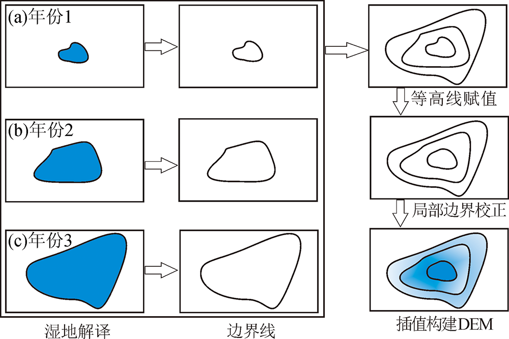
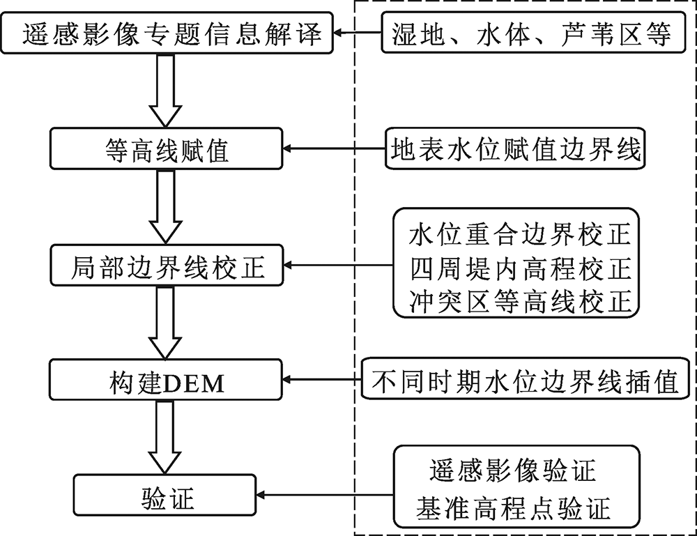
| [1] |
任立良, 刘新仁. 数字高程模型信息提取与数字水文模型研究进展[J]. 水科学进展, 2000,11(4):463-469.
|
| [2] |
汤国安. 我国数字高程模型与数字地形分析研究进展[J]. 地理学报, 2014,69(9):1305-1325.
DOI
URL
|
| [3] |
刘仁义, 刘南. 一种基于数字高程模型DEM的淹没区灾害评估方法[J]. 中国图象图形学报, 2001,6(2):118-122.
DOI
URL
|
| [4] |
何仲太, 侯建军, 宿渊源. IRS-P5影像提取DEM技术在大青山山前断裂古地震研究的应用[J]. 现代地质, 2014,28(6):1243-1251.
|
| [5] |
HODGSON M E, JENSEN J R, SCHMIDT L, et al. An evaluation of LIDAR-and IFSAR-derived digital elevation models in leaf-on conditions with USGS Level 1 and Level 2 DEMs[J]. Remote Sensing of Environment, 2003,84(2):295-308.
|
| [6] |
HIRANO A, WELCH R, LANG H. Mapping from ASTER stereo image data: DEM validation and accuracy assessment[J]. Isprs Journal of Photogrammetry & Remote Sensing, 2003,57(5):356-370.
|
| [7] |
REUTER H I, NELSON A, JARVIS A. An evaluation of void-Filling interpolation methods for SRTM data[J]. International Journal of Geographical Information Science, 2007,21(9):983-1008.
|
| [8] |
CHEN H L, LIANG Q H, LIU Y, et al. Hydraulic correction method (HCM) to enhance the efficiency of SRTM DEM in flood modeling[J]. Journal of Hydrology, 2018,559:56-70.
|
| [9] |
沈欣, 欧阳志云, LEEU W. 利用多时相Landsat影像生成白洋淀湖底DEM的研究[J]. 地理与地理信息科学, 2005,21(2):16-19.
|
| [10] |
沈芳, 郜昂, 吴建平, 等. 淤泥质潮滩水边线提取的遥感研究及DEM构建——以长江口九段沙为例[J]. 测绘学报, 2008,37(1):102-107.
|
| [11] |
齐述华, 顾中宇, BROWN D, 等. 基于数字高程模型的鄱阳湖淹水范围制图研究[J]. 武汉大学学报(信息科学版), 2010,35(7):857-862.
|
| [12] |
林皓波, 吴新玲, 刘菲, 等. 白洋淀湿地资源的遥感监测[J]. 中南林业科技大学学报, 2012,32(4):127-130.
|
| [13] |
沈占锋, 李均力, 于新菊. 基于协同计算的白洋淀湿地时序水体信息提取[J]. 地球信息科学学报, 2016,18(5):690-698.
|
| [14] |
田淑芳, 秦绪文, 郑绵平, 等. 西藏扎布耶盐湖总盐含量遥感定量分析[J]. 现代地质, 2005,19(4):596-602.
|
| [15] |
徐映雪, 邵景力, 杨文丰, 等. 基于RS和GIS的鸭绿江口滨海湿地分类及变化[J]. 现代地质, 2006,20(3):142-146.
|
| [16] |
张皓月, 胡晓农, 王旭升. 巴丹东、西湖地貌演化及其对湖泊水体特征的影响[J]. 现代地质, 2017,31(2):200-208.
|
| [17] |
贾永红, 李芳芳. 一种新的湿地信息遥感提取方法研究[J]. 华中师范大学学报(自然科学版), 2007,41(4):641-644.
|
| [18] |
刘桂林, 张落成, 刘剑, 等. 基于Landsat TM影像的水体信息提取[J]. 中国科学院大学学报, 2013,30(5):644-650.
|
| [19] |
王凯霖, 赵凯, 李海涛, 等. 基于综合识别方法的河北白洋淀湿地提取研究[J]. 现代地质, 2017,31(6):1294-1300.
|
| [20] |
王凯霖, 李海涛, 吴爱民, 等. 人工补水条件下白洋淀湿地演变研究[J]. 地球学报, 2018,39(5):549-558.
|
| [21] |
张东江, 哈建强, 史洪飞. 白洋淀入淀流量变异程度分析[J]. 水资源保护, 2014,30(1):43-47.
|
| [22] |
张赶年. 白洋淀湿地补水的生态补偿研究[D]. 南京: 南京信息工程大学, 2013: 20-31.
|
| [23] |
王秀艳. 白洋淀湿地系统地表水和地下水相互关系的研究[D]. 保定:河北农业大学, 2011: 23-27.
|
| [24] |
董文君. 基于生态需水和生态水权分析的白洋淀湿地补水研究[D]. 南京:南京信息工程大学, 2011: 42-45.
|
| [25] |
王军. Kappa系数在一致性评价中的应用研究[D]. 成都:四川大学, 2006: 17-53.
|
 ), 李海涛2(