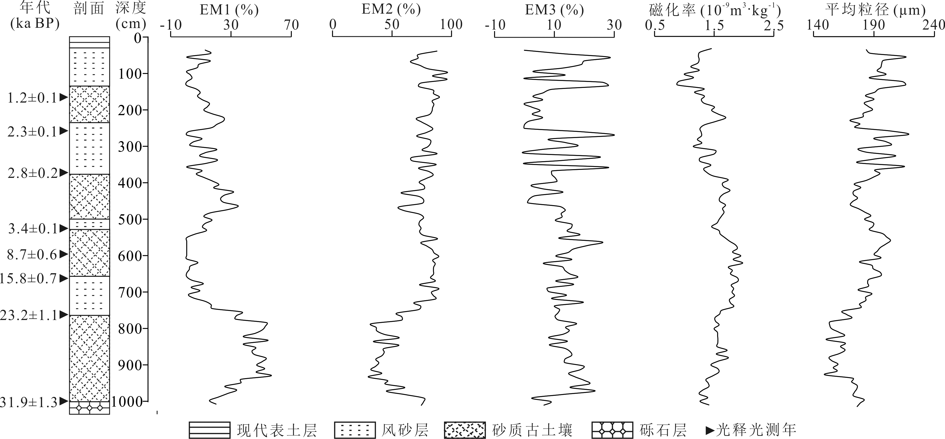
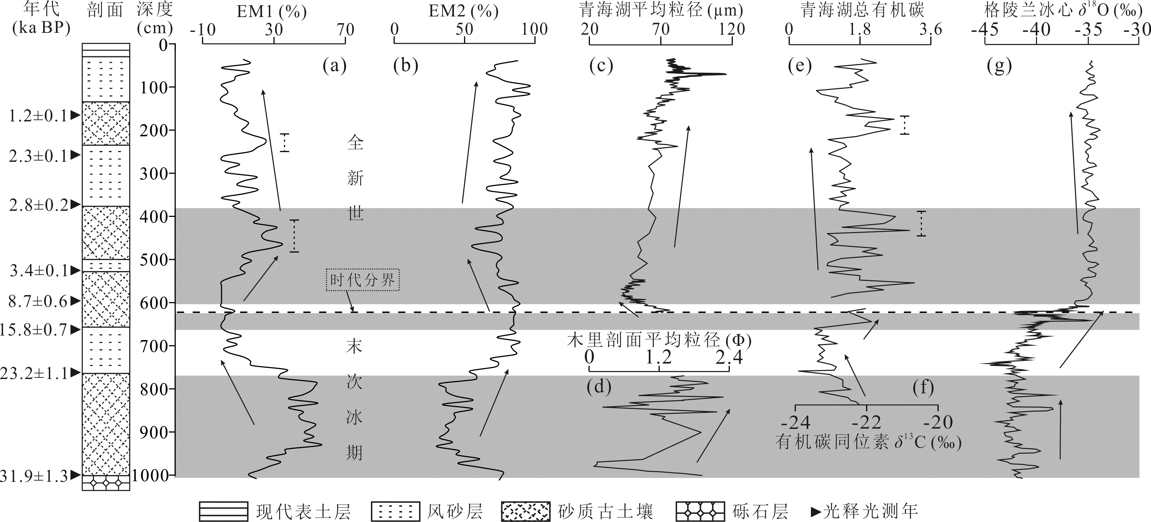
| [1] |
鹿化煜, 安芷生. 黄土高原黄土粒度组成的古气候意义[J]. 中国科学(D辑:地球科学), 1998, 28(3): 278-283.
|
| [2] |
FRIEDMAN G M, SANDERS J E. Principles of Sedimentology[M]. New York: Wiley, 1978.
|
| [3] |
LIU X X, VANDENBERGHE J, AN Z S, et al. Grain size of Lake Qinghai sediments: Implications for riverine input and Holocene monsoon variability[J]. Palaeogeography, Palaeoclimatology, Palaeoecology, 2016, 449: 41-51.
|
| [4] |
刘东生. 黄土与环境[M]. 北京: 科学出版社, 1985.
|
| [5] |
程良清, 宋友桂, 李越, 等. 粒度端元模型在新疆黄土粉尘来源与古气候研究中的初步应用[J]. 沉积学报, 2018, 36(6): 1148-1156.
|
| [6] |
陈海涛, 孔凡彪, 徐树建, 等. 庙岛群岛晚更新世以来黄土粒度端元揭示的粉尘堆积过程[J]. 第四纪研究, 2021, 41(5): 1306-1316.
|
| [7] |
WELTJE G J. End-member modeling of compositional data: Numerical-statistical algorithms for solving the explicit mixing problem[J]. Mathematical Geology, 1997, 29(4): 503-549.
|
| [8] |
PATERSON G A, HESLOP D. New methods for unmixing sediment grain size data[J]. Geochemistry, Geophysics, Geosystems, 2015, 16(12): 4494-4506.
|
| [9] |
梁爱民, 屈建军, 董治宝, 等. 库姆塔格沙漠沉积物粒度端元特征及其物源启示[J]. 中国沙漠, 2020, 40(2): 33-42.
DOI
|
| [10] |
白敏, 鲁瑞洁, 丁之勇, 等. 青海湖湖东沙地粒度端元分析及其指示意义[J]. 第四纪研究, 2020, 40(5): 1203-1215.
|
| [11] |
许可可, 杨振京, 宁凯, 等. 基于端元法的银川盆地MIS6—MIS5气候变化探究[J]. 现代地质, 2021, 35(5): 1311-1322.
|
| [12] |
刘兴起, 姚波, 杨波. 青藏高原北部可可西里库赛湖沉积物及风成物的粒度特征[J]. 第四纪研究, 2010, 30(6): 1193-1198.
|
| [13] |
谢轲, 尹辉. 内蒙古额济纳盆地沉积物粒度特征及沉积环境[J]. 中国沙漠, 2021, 41(6): 111-119.
DOI
|
| [14] |
林镇坤, 王爱军, 叶翔. 南流江河口水下三角洲表层沉积物端元分析及其沉积动力环境意义[J]. 沉积学报, 2019, 37(1): 124-134.
|
| [15] |
张晓东, 季阳, 杨作升, 等. 南黄海表层沉积物粒度端元反演及其对沉积动力环境的指示意义[J]. 中国科学(地球科学), 2015, 45(10): 1515-1523.
|
| [16] |
COLMAN S M, YU S Y, AN Z S, et al. Late Cenozoic climate changes in China’s western interior: A review of research on Lake Qinghai and comparison with other records[J]. Quaternary Science Reviews, 2007, 26(17/18): 2281-2300.
|
| [17] |
袁坤, 金振奎, 彭飚, 等. 青海湖东南岸现代滩坝沉积模式与识别标志[J]. 现代地质, 2020, 34(2): 309-320.
|
| [18] |
刘兴起, 王苏民, 沈吉. 青海湖QH-2000钻孔沉积物粒度组成的古气候古环境意义[J]. 湖泊科学, 2003, 15(2): 112-117.
|
| [19] |
LIU X J, COLMAN S M, BROWN E T, et al. Abrupt deglaciation on the northeastern Tibetan Plateau: Evidence from Lake Qinghai[J]. Journal of Paleolimnology, 2014, 51(2): 223-240.
|
| [20] |
JI J, SHEN J, BALSAM W, et al. Asian monsoon oscillations in the northeastern Qinghai-Tibet Plateau since the late glacial as interpreted from visible reflectance of Qinghai Lake sediments[J]. Earth and Planetary Science Letters, 2005, 233(1/2): 61-70.
|
| [21] |
刘秀铭, 刘东生, 夏敦胜, 等. 中国与西伯利亚黄土磁化率古气候记录-氧化和还原条件下的两种成土模式分析[J]. 中国科学(D辑:地球科学), 2007, 37(10): 1382-1391.
|
| [22] |
张姚, 吴铎, 张欢, 等. 不同时间尺度青海湖沉积物总有机碳对气候变化的敏感性[J]. 湖泊科学, 2019, 31(5): 1468-1478.
|
| [23] |
CHENG B, CHEN F H, ZHANG J W. Palaeovegetational and palaeoenvironmental changes since the last deglacial in Gonghe Basin, northeast Tibetan Plateau[J]. Journal of Geographical Sciences, 2013, 23(1): 136-146.
DOI
|
| [24] |
王建国, 马海州, 谭红兵, 等. 青海湖南岸黑马河黄土剖面碳酸盐含量与记录的古气候变化[J]. 盐湖研究, 2005, 13(4): 5-8.
|
| [25] |
LU R J, JIA F F, GAO S Y, et al. Holocene aeolian activity and climatic change in Qinghai Lake Basin, northeastern Qinghai-Tibetan Plateau[J]. Palaeogeography, Palaeoclimatology, Palaeoecology, 2015, 430: 1-10.
|
| [26] |
沈吉, 刘兴起, MATSUMOTO R, 等. 晚冰期以来青海湖沉积物多指标高分辨率的古气候演化[J]. 中国科学(D辑:地球科学), 2004, 34(6): 582-589.
|
| [27] |
陈启林, 黎瑞, 金振奎, 等. 青海湖滩坝分布规律及其古气候意义[J]. 现代地质, 2019, 33(1): 187-197.
|
| [28] |
王中, 刘向军, 丛禄. 青海湖东岸末次冰期冰盛期和早全新世沙漠范围重建[J]. 盐湖研究, 2017, 25(2): 67-75.
|
| [29] |
XIAO J L, PORTER S C, AN Z S, et al. Grain size of quartz as an indicator of winter monsoon strength on the Loess Plateau of central China during the last 130,000 yr[J]. Quaternary Research, 1995, 43(1): 22-29.
|
| [30] |
余雪飞, 李保生, 靳鹤龄, 等. 末次间冰期全球变化区域响应的粒度旋回: 萨拉乌苏河流域米浪沟湾剖面记录[J]. 华南师范大学学报(自然科学版), 2004, 36(1): 129-135.
|
| [31] |
PYE K. Aeolian Dust and Dust Deposits[M]. London: Academic Press, 1987.
|
| [32] |
刘秀铭, 刘东生, SHAW John. 中国黄土磁性矿物特征及其古气候意义[J]. 第四纪研究, 1993, 13(3): 281-287.
|
| [33] |
陈渠, 刘秀铭, 吕镔, 等. 天山北麓黄土记录的30万年以来古气候演变[J]. 沉积学报, 2022, 40(3): 679-690.
|
| [34] |
连悦辰, 刘秀铭, 何玲珊, 等. 伊朗西部Shooshtar黄土岩石磁学特征及增强机制研究[J]. 第四纪研究, 2022, 42(1): 272-287.
|
| [35] |
牛光明, 强明瑞, 宋磊, 等. 5000a来柴达木盆地东南缘风成沉积记录的冬季风演化[J]. 中国沙漠, 2010, 30(5): 1031-1039.
|
| [36] |
VRIEND M, PRINS M A, BUYLAERT J P, et al. Contrasting dust supply patterns across the north-western Chinese Loess Plateau during the last glacial-interglacial cycle[J]. Quaternary International, 2011, 240(1/2): 167-180.
|
| [37] |
VANDENBERGHE J. Grain size of fine-grained windblown sediment: A powerful proxy for process identification[J]. Earth-Science Reviews, 2013, 121: 18-30.
|
| [38] |
隆浩, 王乃昂, 马海州, 等. 腾格里沙漠西北缘湖泊沉积记录的区域风沙特征[J]. 沉积学报, 2007, 25(4): 626-631.
|
| [39] |
汪海斌, 陈发虎, 张家武. 黄土高原西部地区黄土粒度的环境指示意义[J]. 中国沙漠, 2002, 22(1): 21-26.
|
| [40] |
李帅. 青藏高原东部黄土粒度端元分析及其指示意义[D]. 兰州: 兰州大学, 2018.
|
| [41] |
李帅, 杨胜利, 梁敏豪, 等. 青藏高原东部黄土粒度分布的端元模型研究[J]. 地球与环境, 2018, 46(4): 331-338.
|
| [42] |
任建武. 青海天峻木里冻土区末次冰期以来的气候变化研究[D]. 北京: 中国地质大学(北京), 2015.
|
| [43] |
黄猛, 韩荣文, 牛毅, 等. 渤海湾西北岸MIS3阶段以来的海侵特征[J]. 地质通报, 2021, 40(5): 721-733.
|
| [44] |
潘保田, 陈发虎. 青藏高原东北部15万年来的多年冻土演化[J]. 冰川冻土, 1997, 19(2): 123-132.
|
| [45] |
刘兴起, 沈吉, 王苏民, 等. 青海湖16ka以来的花粉记录及其古气候古环境演化[J]. 科学通报, 2002, 47(17): 1351-1355.
|
| [46] |
陶涛, 王超群, 戚帮申, 等. 青海湖鸟岛北原生砂楔的发现及其古气候意义[J]. 第四纪研究, 2016, 36(5): 1246-1252.
|
| [47] |
LIN B H, LIU R M, AN Z S. Preliminary research on stable isotopic compositions of Chinese Loess[M]//LIU D S. Loess Environment and Global Change[M]. Beijing: Science Press, 1991: 124-131.
|
| [48] |
李月, 许冬, 张志毅, 等. 西太平洋E20岩芯末次冰期以来的沉积特征与环境意义[J]. 海洋学研究, 2021, 39(2): 12-20.
|
| [49] |
贾玉连, 施雅风, 王苏民, 等. 40ka以来青藏高原的4次湖涨期及其形成机制初探[J]. 中国科学(D辑:地球科学), 2001, 31(增): 241-251.
|
| [50] |
姚檀栋. 末次冰期青藏高原的气候突变: 古里雅冰芯与格陵兰GRIP冰芯对比研究[J]. 中国科学(D辑:地球科学), 1999, 29(2): 175-184.
|
| [51] |
薛红盼, 曾方明. 青海湖东岸全新世风成沉积地球化学特征及其古气候意义[J]. 沉积学报, 2021, 39(5): 1198-1207.
|
| [52] |
高尚玉, 王贵勇, 哈斯, 等. 末次冰期以来中国季风区西北边缘沙漠演化研究[J]. 第四纪研究, 2001, 21(1): 66-71.
|
| [53] |
史基安, 郭雪莲, 王琪, 等. 青海湖QH1孔晚全新世沉积物稀土元素地球化学与气候环境关系探讨[J]. 湖泊科学, 2003, 15(1): 28-34.
|
| [54] |
陈发虎, 饶志国, 张家武, 等. 陇西黄土高原末次冰期有机碳同位素变化及其意义[J]. 科学通报, 2006, 51(11): 1310-1317.
|
 ), 许澳康, 孙文丽, 庄静