

现代地质 ›› 2021, Vol. 35 ›› Issue (01): 209-219.DOI: 10.19657/j.geoscience.1000-8527.2021.016
马鑫1( ), 付雷1(), 李铁锋1, 闫晶2, 刘廷1, 王明国1, 邵炜1
收稿日期:2020-10-09
修回日期:2020-12-14
出版日期:2021-02-12
发布日期:2021-03-12
通讯作者:
付雷
作者简介:付 雷,男,工程师,1986年出生,水文与水资源工程专业,主要从事水文地质与地热地质调查研究。Email: fulei@mail.cgs.gov.cn。基金资助:
MA Xin1(), FU Lei1(), LI Tiefeng1, YAN Jing2, LIU Ting1, WANG Mingguo1, SHAO Wei1
Received:2020-10-09
Revised:2020-12-14
Online:2021-02-12
Published:2021-03-12
Contact:
FU Lei
摘要:
喜马拉雅东构造结地区是现今地球上构造活动最强烈、地貌演化最快的地区之一,属于地中海—喜马拉雅地热带,水热活动强烈。基于喜马拉雅东构造结的地热地质背景,采用野外调查、水化学和稳定同位素测试分析等手段,初步分析嘉黎地区深部地下热水发育特征及成因模式。结果表明,该区域地下热水均来自大气降水或冰雪融水,补给高程位于4 500 m以上,推测补给区位于研究区西北部片麻岩山区;区内地下热水均为未成熟水,热水补给水源沿断裂循环至深部热储,随后受热对流上升至地表出露成温泉,热水上升至浅表部与冷水发生混合,冷热水最大混合比可达91%;采用二氧化硅温度计、阳离子温度计以及硅-焓模型估算出热储温度最高达380 ℃,热水在雅鲁藏布江结合带内循环深度达到6 900 m。研究区深部热源主要来自雅鲁藏布江结合带及附近深大断裂,地表热显示主要受控于结合带两侧的次级张扭性断裂。本研究初步揭示了喜马拉雅东构造结嘉黎地区地热成因模式,可为该区重大工程建设和高温热害防治提供指导。
中图分类号:
马鑫, 付雷, 李铁锋, 闫晶, 刘廷, 王明国, 邵炜. 喜马拉雅东构造结地区地热成因分析[J]. 现代地质, 2021, 35(01): 209-219.
MA Xin, FU Lei, LI Tiefeng, YAN Jing, LIU Ting, WANG Mingguo, SHAO Wei. Analysis of Geothermal Origin in Eastern Himalayan Syntaxis[J]. Geoscience, 2021, 35(01): 209-219.

图1 研究区地理位置及地质图
Fig.1 Geological map and location of the study area

图2 川西藏东地区大地热流值等值线分布图(据“全国大地热流数据汇编资料及调查成果”编制)[2,11]
Fig.2 Distribution map of geothermal heat flow value contours in western Sichuan and eastern Tibet (compiled according to “the compilation data and survey results of the national geothermal heat flow data” ) [2,11]

图3 长青温泉(a)与排龙温泉(b)
Fig.3 Photos of Changqing hot spring (a) and Pailong hot spring (b)
| 送样 编号 | 温度/℃ | Na+/ (mg/L) | K+/ (mg/L) | Ca2+/ (mg/L) | Mg2+/ (mg/L) | Cl-/ (mg/L) | SO42-/ (mg/L) | CO32-/ (mg/L) |
|---|---|---|---|---|---|---|---|---|
| Q1 | 95.0 | 598.72 | 98.39 | <3.00 | <3.00 | 368.40 | 252.86 | 336.78 |
| Q2 | 77.5 | 324.50 | 45.32 | 148.46 | 16.09 | 111.40 | 494.02 | <5.00 |
| Q3 | 40.2 | 113.54 | 25.55 | 154.79 | 28.25 | 87.84 | 143.82 | <5.00 |
| ZK1 | 19.2 | 7.57 | 14.65 | 385.57 | 27.28 | 0.44 | 999.15 | <5.00 |
| ZK2 | 53.1 | 233.13 | 24.13 | 180.84 | 29.51 | 168.50 | 165.85 | <5.00 |
| S1 | 4.2 | 1.07 | 0.59 | <3.00 | <3.00 | 1.67 | 0.17 | <5.00 |
| S2 | 7.6 | 54.20 | <0.05 | 21.80 | <3.00 | 5.80 | 102.80 | <5.00 |
| S3 | 8.5 | 51.70 | <0.05 | 22.60 | <3.00 | 6.40 | 376.02 | <5.00 |
| Y1 | 8.6 | 0.76 | 0.25 | <3.00 | <3.00 | 1.45 | 0.63 | <5.00 |
| 送样 编号 | pH | HCO3-/ (mg/L) | 偏硅酸/ (mg/L) | Li+/ (mg/L) | F-/ (mg/L) | Sr2+/ (mg/L) | 矿化度/ (mg/L) | 水化学类型 |
| Q1 | 9.79 | 38.52 | 345.30 | 2.532 | 7.98 | 0.252 | 1 688 | CO3·Cl-Na |
| Q2 | 7.95 | 643.76 | 225.53 | 0.408 | 3.70 | 0.817 | 1 467 | HCO3·SO4-Na·Ca |
| Q3 | 7.63 | 673.66 | 159.39 | 0.445 | 1.33 | 1.029 | 894 | HCO3-Ca·Na |
| ZK1 | 7.59 | 181.23 | 41.86 | 0.017 | 0.35 | 6.876 | 1 529 | SO4-Ca |
| ZK2 | 7.97 | 821.50 | 44.82 | 0.374 | 0.28 | 2.156 | 1 267 | HCO3-Ca·Na |
| S1 | 6.91 | 15.26 | <0.06 | 0.01 | 103 | HCO3-Na | ||
| S2 | 7.78 | 60.80 | <0.06 | 0.01 | 224 | HCO3·SO4-Na·Ca | ||
| S3 | 7.62 | 36.20 | <0.06 | 0.02 | 621 | SO4-Na·Ca | ||
| Y1 | 6.87 | 10.98 | <0.06 | 0 | 33 | HCO3-Na |
表1 水样水化学及同位素测试结果
Table 1 Hydrochemical and isotope measurement results of water samples
| 送样 编号 | 温度/℃ | Na+/ (mg/L) | K+/ (mg/L) | Ca2+/ (mg/L) | Mg2+/ (mg/L) | Cl-/ (mg/L) | SO42-/ (mg/L) | CO32-/ (mg/L) |
|---|---|---|---|---|---|---|---|---|
| Q1 | 95.0 | 598.72 | 98.39 | <3.00 | <3.00 | 368.40 | 252.86 | 336.78 |
| Q2 | 77.5 | 324.50 | 45.32 | 148.46 | 16.09 | 111.40 | 494.02 | <5.00 |
| Q3 | 40.2 | 113.54 | 25.55 | 154.79 | 28.25 | 87.84 | 143.82 | <5.00 |
| ZK1 | 19.2 | 7.57 | 14.65 | 385.57 | 27.28 | 0.44 | 999.15 | <5.00 |
| ZK2 | 53.1 | 233.13 | 24.13 | 180.84 | 29.51 | 168.50 | 165.85 | <5.00 |
| S1 | 4.2 | 1.07 | 0.59 | <3.00 | <3.00 | 1.67 | 0.17 | <5.00 |
| S2 | 7.6 | 54.20 | <0.05 | 21.80 | <3.00 | 5.80 | 102.80 | <5.00 |
| S3 | 8.5 | 51.70 | <0.05 | 22.60 | <3.00 | 6.40 | 376.02 | <5.00 |
| Y1 | 8.6 | 0.76 | 0.25 | <3.00 | <3.00 | 1.45 | 0.63 | <5.00 |
| 送样 编号 | pH | HCO3-/ (mg/L) | 偏硅酸/ (mg/L) | Li+/ (mg/L) | F-/ (mg/L) | Sr2+/ (mg/L) | 矿化度/ (mg/L) | 水化学类型 |
| Q1 | 9.79 | 38.52 | 345.30 | 2.532 | 7.98 | 0.252 | 1 688 | CO3·Cl-Na |
| Q2 | 7.95 | 643.76 | 225.53 | 0.408 | 3.70 | 0.817 | 1 467 | HCO3·SO4-Na·Ca |
| Q3 | 7.63 | 673.66 | 159.39 | 0.445 | 1.33 | 1.029 | 894 | HCO3-Ca·Na |
| ZK1 | 7.59 | 181.23 | 41.86 | 0.017 | 0.35 | 6.876 | 1 529 | SO4-Ca |
| ZK2 | 7.97 | 821.50 | 44.82 | 0.374 | 0.28 | 2.156 | 1 267 | HCO3-Ca·Na |
| S1 | 6.91 | 15.26 | <0.06 | 0.01 | 103 | HCO3-Na | ||
| S2 | 7.78 | 60.80 | <0.06 | 0.01 | 224 | HCO3·SO4-Na·Ca | ||
| S3 | 7.62 | 36.20 | <0.06 | 0.02 | 621 | SO4-Na·Ca | ||
| Y1 | 6.87 | 10.98 | <0.06 | 0 | 33 | HCO3-Na |
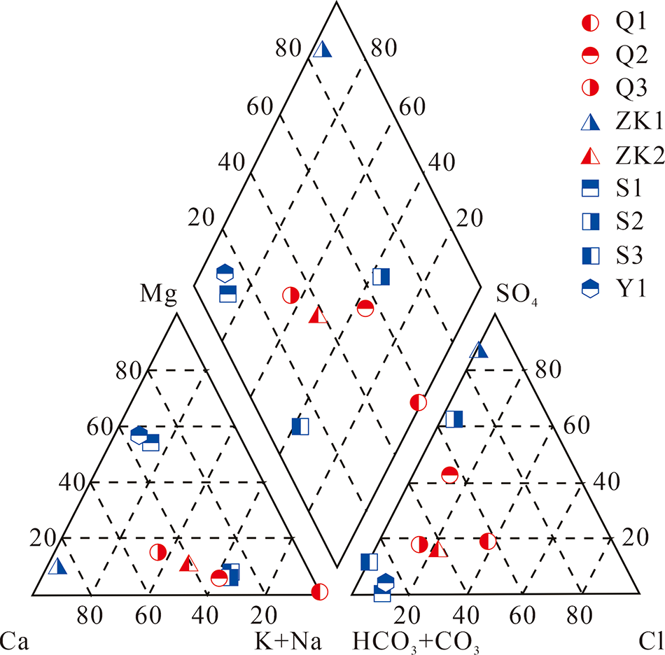
图4 水化学三线图(单位:%)
Fig.4 Trilinear chart of water samples(unit: %)
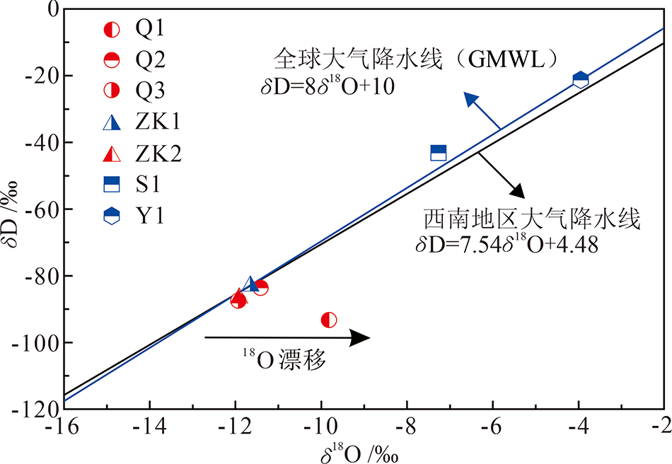
图5 温泉及河流水样氢氧稳定同位素分布特征
Fig.5 δD vs. δ18O plot of geothermal water and river water
| 取样点 | 采样高程/m | 样品δ18O/‰ | 样品δD/‰ | 降水δD/‰ | ρ/(‰/hm) | 补给高程/m |
|---|---|---|---|---|---|---|
| Q1(长青温泉) | 1 982 | -9.82 | -93.28 | -20.85 | -2.5 | 4 879.2 |
| Q2(排龙温泉) | 2 033 | -11.43 | -83.51 | -20.85 | -2.5 | 4 539.4 |
| Q3(拉月温泉) | 2 265 | -11.91 | -87.70 | -20.85 | -2.5 | 4 939.0 |
| ZK2(测温孔) | 2 650 | -11.91 | -86.94 | -20.85 | -2.5 | 5 293.6 |
表2 研究区地下热水氢氧同位素组成与补给高程
Table 2 Estimated altitude, δD and δ18O of the thermal water samples from the study area
| 取样点 | 采样高程/m | 样品δ18O/‰ | 样品δD/‰ | 降水δD/‰ | ρ/(‰/hm) | 补给高程/m |
|---|---|---|---|---|---|---|
| Q1(长青温泉) | 1 982 | -9.82 | -93.28 | -20.85 | -2.5 | 4 879.2 |
| Q2(排龙温泉) | 2 033 | -11.43 | -83.51 | -20.85 | -2.5 | 4 539.4 |
| Q3(拉月温泉) | 2 265 | -11.91 | -87.70 | -20.85 | -2.5 | 4 939.0 |
| ZK2(测温孔) | 2 650 | -11.91 | -86.94 | -20.85 | -2.5 | 5 293.6 |
| 水样编号 | T | 石英1温标 | 石英2温标 | 石英3温标 | 玉髓温标 | K-Mg温标 | Na-K温标 | Na-K-Ca温标 |
|---|---|---|---|---|---|---|---|---|
| Q1 | 95.0 | 182.07 | 181.41 | 169.33 | 160.52 | 147.20 | 275.33 | 259.05 |
| Q2 | 77.5 | 154.22 | 153.97 | 146.75 | 129.24 | 97.62 | 260.46 | 192.57 |
| Q3 | 40.2 | 135.33 | 135.17 | 131.01 | 108.25 | 75.85 | 306.58 | 199.55 |
表3 研究区深部热储温度计算结果(℃)
Table 3 Calculation results of reservoir temperatures in the study area(℃)
| 水样编号 | T | 石英1温标 | 石英2温标 | 石英3温标 | 玉髓温标 | K-Mg温标 | Na-K温标 | Na-K-Ca温标 |
|---|---|---|---|---|---|---|---|---|
| Q1 | 95.0 | 182.07 | 181.41 | 169.33 | 160.52 | 147.20 | 275.33 | 259.05 |
| Q2 | 77.5 | 154.22 | 153.97 | 146.75 | 129.24 | 97.62 | 260.46 | 192.57 |
| Q3 | 40.2 | 135.33 | 135.17 | 131.01 | 108.25 | 75.85 | 306.58 | 199.55 |
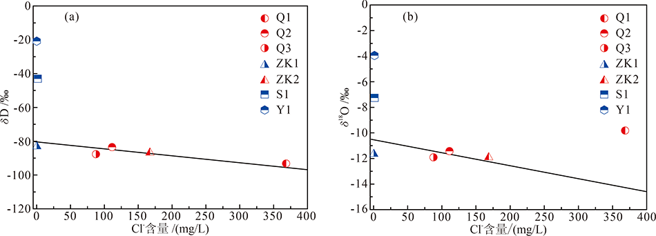
图6 研究区水样离子相关性图
Fig.6 Relations between Cl- and H-O isotopes in thermal water samples from the study area

图7 研究区温泉水样Na-K-Mg三角图(单位: %)
Fig.7 Ternary diagram of Na-K-Mg for thermal water samples from the study area(unit: %)
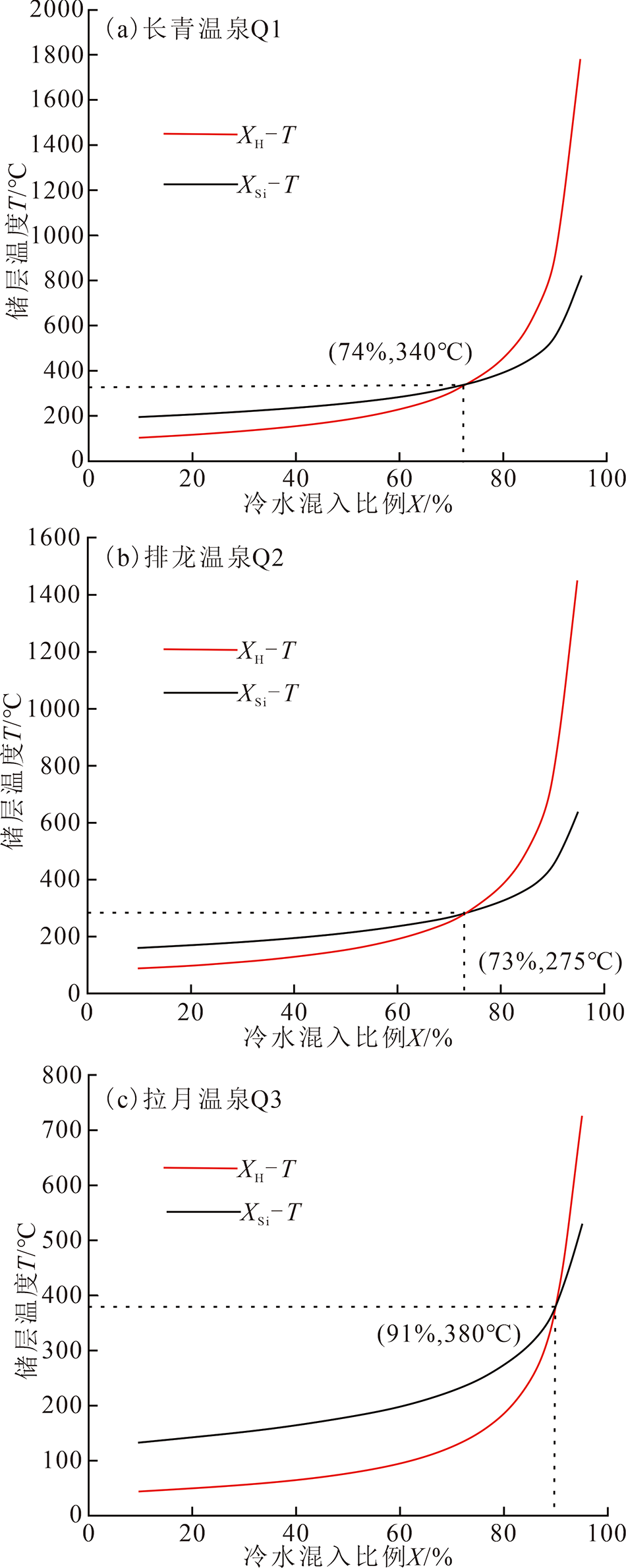
图8 温泉水样硅-焓模型图解
Fig.8 Diagrams of silica-enthalpy model for thermal watersamples

图9 东喜马拉雅构造结边界断裂带变形构造 (a1)拉月—迫隆乡段运动学特征;(b1)鲁朗—拉月段运动学特征;(c1)嘎马—米林段运动学特征;(a2)甘登—加拉萨段运动学特征;(b2)旁辛—达木段运动特征;(c2)阿尼桥—希让段运动学特征;据董汉文等[9]修改
Fig.9 Boundary fault deformation of the eastern Himalayan syntaxis
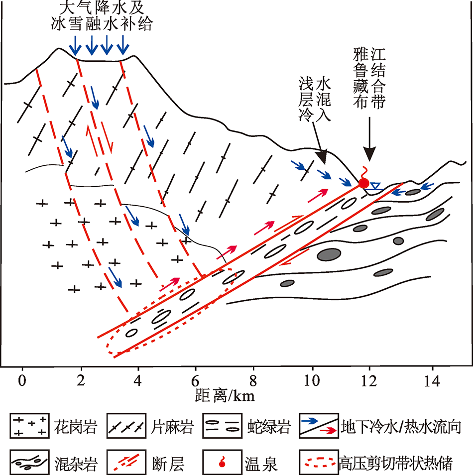
图10 喜马拉雅东构造地区地热系统成因模式
Fig.10 Genetic model of the eastern Himalayan syntaxis geothermal system
| [1] | 廖昕, 蒋翰, 徐正宣, 等. 西藏东部阿旺地下热水化学特征及其成因初探[J]. 工程地质学报, 2020,28(4):916-924. |
| [2] | 郭长宝, 张永双, 蒋良文, 等. 川藏铁路沿线及邻区环境工程地质问题概论[J]. 现代地质, 2017,31(5):877-889. |
| [3] | 多吉. 典型高温地热系统——羊八井热田基本特征[J]. 中国工程科学, 2003,5(1):42-47. |
| [4] | 张萌, 蔺文静, 刘昭, 等. 西藏谷露高温地热系统水文地球化学特征及成因模式[J]. 成都理工大学学报(自然科学版), 2014,41(3):382-392. |
| [5] | 王鹏, 陈晓宏, 沈立成, 等. 西藏地热异常区热储温度及其地质环境效应[J]. 中国地质, 2016,43(4):1429-1438. |
| [6] | 郭宁, 刘昭, 男达瓦, 等. 西藏昌都觉拥温泉水化学特征及热储温度估算[J]. 地质论评, 2020,66(2):499-509. |
| [7] | 孙红丽, 马峰, 蔺文静, 等. 西藏高温地热田地球化学特征及地热温标应用[J]. 地质科技情报, 2015,34(3):171-177. |
| [8] | 丁林, MAKSATBEK S, 蔡福龙, 等. 印度与欧亚大陆初始碰撞时限、封闭方式和过程[J]. 中国科学:地球科学, 2017,47(3):293-309. |
| [9] | 董汉文, 许志琴, 曹汇, 等. 东喜马拉雅构造结东、西边界断裂对比及其构造演化过程[J]. 地球科学, 2018,43(4):933-951. |
| [10] | 张鹏, 曲亚明, 郭长宝, 等. 西藏林芝地应力测量监测与尼泊尔MS8.1级强震远场响应分析[J]. 现代地质, 2017,31(5):900-910. |
| [11] | 姜光政, 高堋, 饶松, 等. 中国大陆地区大地热流数据汇编(第四版)[J]. 地球物理学报, 2016,59(8):2892-2910. |
| [12] | 秦大军, 孙杰, 郭艺, 等. 永定河对北京西山岩溶水和玉泉山泉的影响[J]. 工程地质学报, 2019,27(1):162-169. |
| [13] |
CRAIG H. Standard for reporting concentrations of deuterium and oxygen-18 in natural water[J]. Science, 1961,133:1833-1834.
DOI URL PMID |
| [14] | 卫克勤, 林瑞芬, 王志祥. 西藏羊八井地热水的氢、氧稳定同位素组成及氚含量[J]. 地球化学, 1983,12(4):338-346. |
| [15] | 赵永红, 杨家英, 王航, 等. 地热水氢氧同位素分布特性[J]. 地球物理学进展, 2017,32(6):2415-2423. |
| [16] | WANG S F, PANG Z H, LIU J R, et al. Origin and evolution characteristics of geothermal water in the Niutuozhen geothermal field,North China Plain[J]. Journal of Earth Science, 2013,24(6):891-902. |
| [17] | LUO L, PANG Z H, LIU J X, et al. Determining the recharge sources and circulation depth of thermal waters in Xianyang geothermal field in Guanzhong Basin: The controlling role of Weibei Fault[J]. Geothermics, 2017,69:55-64. |
| [18] | YILDIRIM B, ÖZGÜR N. Hydrogeological,hydrogeochemical and isotope geochemical features of geothermal waters in Tekkehamam and environs, western Anatolia,Turkey[J]. Procedia Earth and Planetary Science, 2017,17:177-180. |
| [19] | MINISSALE A, CORTI G, TASSI F, et al. Geothermal potential and origin of natural thermal fluids in the northern Lake Abaya area, Main Ethiopian Rift, East Africa[J]. Journal of Volcanology and Geothermal Research, 2017,336:1-18. |
| [20] | 郝彦珍, 潘明, 吕勇, 等. 云南昌宁柯街断裂带温泉水化学特征[J]. 地质科技情报, 2014,33(4):191-196. |
| [21] | 王礼恒, 董艳辉, 周鹏鹏, 等. 阿拉善塔木素地段地下水补给来源与演化特征分析[J]. 工程地质学报, 2019,27(3):691-698. |
| [22] | 汪集旸, 熊亮萍, 庞忠和. 中低温对流型地热系统[M]. 北京: 科学出版社, 1993: 44-82. |
| [23] | HAN D M, LIANG X, JIN M G, et al. Evaluation of groundwater hydrochemical characteristics and mixing behavior in the Daying and Qicun geothermal systems, Xinzhou Basin[J]. Journal of Volcanology and Geothermal Research, 2010,189(1/2):92-104. |
| [24] | PEIFFER L, WANNER C, SPYCHER N, et al. Optimized multicomponent vs. classical geothermometry:Insights from modeling studies at the Dixie Valley geothermal area[J]. Geothermics, 2014,51:154-169. |
| [25] | GUO Q, PANG Z H, WANG Y C, et al. Fluid geochemistry and geothermometry applications of the Kangding high-temperature geothermal system in eastern Himalayas[J]. Applied Geochemistry, 2017,81:63-75. |
| [26] | 李洁祥, 郭清海, 余正艳. 高温地热系统中粘土矿物形成对Na-K和K-Mg地球化学温标准确性的影响[J]. 地球科学, 2017,42(1):142-154. |
| [27] | FOURNIER R O. Chemical geothermometers and mixing models for geothermal systems[J]. Geothermics, 1977,5(1/2/3/4):41-50. |
| [28] | GIGGENBACH W F. Geothermal solute equilibria: Derivation of Na-K-Mg-Ca geoindicators[J]. Geochimica et Cosmochimica Acta, 1988,52(12):2749-2765. |
| [29] | 顾晓敏. 阿尔山泉群地球化学特征及成因演化机制研究[D]. 北京:中国地质大学(北京), 2018: 80-101. |
| [30] | ARNÓRSSON S, ANDRÉSDÓTTIR A. Processes controlling the distribution of boron and chlorine in natural waters in Iceland[J]. Geochimica et Cosmochimica Acta, 1995,59:4125-4146. |
| [31] | 李晓, 王金金, 黄珣, 等. 鲜水河断裂带康定至道孚段热水化学与同位素特征[J]. 成都理工大学学报(自然科学版), 2018,45(6):733-745. |
| [32] | 王莹, 周训, 于湲, 等. 应用地热温标估算地下热储温度[J]. 现代地质, 2007,21(4):605-612. |
| [33] | 郑来林, 金振民, 潘桂棠, 等. 东喜马拉雅南迦巴瓦地区区域地质特征及构造演化[J]. 地质学报, 2004,78(6):744-751. |
| [34] | 张健, 李午阳, 唐显春, 等. 川西高温水热活动区的地热学分析[J]. 中国科学:地球科学, 2017,47(8):899-915. |
| [1] | 姜哲, 周训, 陈柄桦, 陶广斌, 李状, 曹入文, 隋丽嫒. 四川康定市二道桥地区地下热水稳定同位素特征及热储温度计算[J]. 现代地质, 2022, 36(04): 1183-1192. |
| [2] | 王艺璇, 周训, 陈梦颖, 马静茹, 海阔, 肖萌, 尚子琦, 张颖, 余鸣潇. 河北北部四处温泉的水化学特征及成因分析[J]. 现代地质, 2022, 36(02): 494-506. |
| [3] | 胡泽祥, 赵学钦, 李松, 李军亚, 王玉珏, 杨洛. 色达—松潘断块温泉水文地球化学特征及成因分析[J]. 现代地质, 2022, 36(02): 484-493. |
| [4] | 吴通航, 刘海燕, 张卫民, 孙占学, 王振, 刘茂涵. 鄱阳湖流域赣江下游水化学特征及人类健康风险评价[J]. 现代地质, 2022, 36(02): 427-438. |
| [5] | 卢丽, 陈余道, 代俊鸽, 王喆, 邹胜章, 樊连杰, 林永生, 周长松. 四川昭觉竹核温泉水文地球化学特征及成因[J]. 现代地质, 2021, 35(03): 703-710. |
| [6] | 蒋万军,赵丹,王广才,郭永海,刘成龙,钟涛,刘淑芬,. 新疆吐-哈盆地地下水水文地球化学特征及形成作用[J]. 现代地质, 2016, 30(4): 825-833. |
| [7] | 冯海波,董少刚,史晓珑,王克玲,刘白薇,李政葵,刘晓波. 内蒙古托克托县潜水与承压水中氟化物的空间分布特征及形成机理[J]. 现代地质, 2016, 30(3): 672-679. |
| [8] | 郭华明,倪萍,贾永锋,张波,张扬. 内蒙古河套盆地地表水-浅层地下水化学特征及成因[J]. 现代地质, 2015, 29(2): 229-237. |
| [9] | 韦红钢. 铀在北山花岗岩中的吸附迁移影响因素研究[J]. 现代地质, 2012, 26(4): 823-828. |
| [10] | 陈倩, 钟金先, 李长顺. 数理统计方法在区域浅层地下水水文地球化学研究中的应用[J]. 现代地质, 2012, 26(3): 607-613. |
| [11] | 黄平华, 陈建生, 宁超, 韩素敏. 焦作矿区地下水水化学特征及其地球化学模拟[J]. 现代地质, 2010, 24(2): 369-376. |
| [12] | 王莹,周训,于湲,柳春晖,周海燕. 应用地热温标估算地下热储温度[J]. 现代地质, 2007, 21(4): 605-612. |
| [13] | 周海燕,周训,姚锦梅. 广东从化温泉的水文地球化学模拟[J]. 现代地质, 2007, 21(4): 619-623. |
| [14] | 姚锦梅,周 训,周海燕. 天津市宁河北奥陶系灰岩水源地的水文地球化学模拟[J]. 现代地质, 2006, 20(3): 494-499. |
| 阅读次数 | ||||||
|
全文 |
|
|||||
|
摘要 |
|
|||||