

现代地质 ›› 2018, Vol. 32 ›› Issue (04): 807-818.DOI: 10.19657/j.geoscience.1000-8527.2018.04.17
付超1( ), 于兴河1(), 何玉林2, 梁金强2, 匡增桂2, 董亦思3, 金丽娜1
收稿日期:2017-07-12
修回日期:2018-01-11
出版日期:2018-08-10
发布日期:2018-09-19
通讯作者:
于兴河
作者简介:于兴河,男,教授,1958年出生,能源地质工程专业,从事海洋沉积学等方面研究。Email:Billyu@cugb.edu.cn。基金资助:
FU Chao1(), YU Xinghe1(), HE Yulin2, LIANG Jinqiang2, KUANG Zenggui2, DONG Yisi3, JIN Lina1
Received:2017-07-12
Revised:2018-01-11
Online:2018-08-10
Published:2018-09-19
Contact:
YU Xinghe
摘要:
南海北部陆坡神狐海域峡谷作为我国水合物首次试采区,其沉积层序特征控制和影响着富含水合物沉积体的展布。海域峡谷区沉积作用复杂,影响因素较多,对比难度较大一直是全球深海沉积研究的难题之一。研究采用井震综合分析的方法识别出层序界面,并结合峡谷侵蚀—充填过程,刻画出不同级次的层序界面在空间上的展布。研究划分出6个四级层序,但是各层序内部同相轴发育特征不同:层序Ⅲ和层序Ⅳ的底界可见明显的下切谷和峡谷定向迁移现象,层序Ⅴ和层序Ⅵ层序可见明显的同相轴错断现象。依据层序结构样式存在的差异,将研究区层序类型分成物源驱动型层序和沉降驱动型层序。然后统计层序Ⅰ—Ⅳ内部的沉积参数,根据陆坡滨岸线的演化过程将物源驱动型层序和沉降驱动型层序进行体系域划分。最后将两种类型的层序进行解剖并提出对应的演化模式:物源驱动型层序可以再划分成3个体系域,即低位域、海侵域和高位域,整体物源供给较充足,沟谷侵蚀现象明显,陆坡滨岸线多呈上超结构;沉降驱动型层序划分成4个体系域,即低位域、海侵域、高位域和海退域,其中海退体系域为最大海泛面和峡谷侵蚀面间的规则前积体,层序发育过程伴随断裂沉降,陆坡滨岸线多呈S型结构。
中图分类号:
付超, 于兴河, 何玉林, 梁金强, 匡增桂, 董亦思, 金丽娜. 南海北部神狐海域峡谷层序结构差异与控制因素[J]. 现代地质, 2018, 32(04): 807-818.
FU Chao, YU Xinghe, HE Yulin, LIANG Jinqiang, KUANG Zenggui, DONG Yisi, JIN Lina. Stratigraphic and Structural Differences and Their Controls in the Shenhu Submarine Canyon,Northern South China Sea[J]. Geoscience, 2018, 32(04): 807-818.

图1 2015年神狐水合物钻探区位置及本次研究中使用的水合物钻探井位置 (a)构造分区;(b)海底地貌;(c)综合柱状图;1.开云低凸起;2.番禺低凸起;3.东沙隆起;4.白云凹陷
Fig.1 Location of the gas hydrate drilling sites in 2015 (study area), and those analyzed in this study
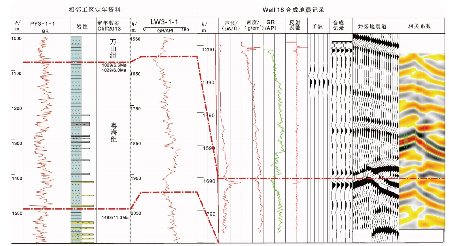
图2 三级层序界面确定与合成地震记录
Fig.2 Three-order stratigraphic boundary identification and synthetic seismograms

图3 不同类型水道侵蚀与三级层序界面识别
Fig.3 Different canyon evolution stages and the identified three-order stratigraphic boundary

图4 四级次水道侵蚀识别和井震结合层序划分
Fig.4 Four-order stratigraphic boundary distinguished and the integrated core-well-seismic data analysis
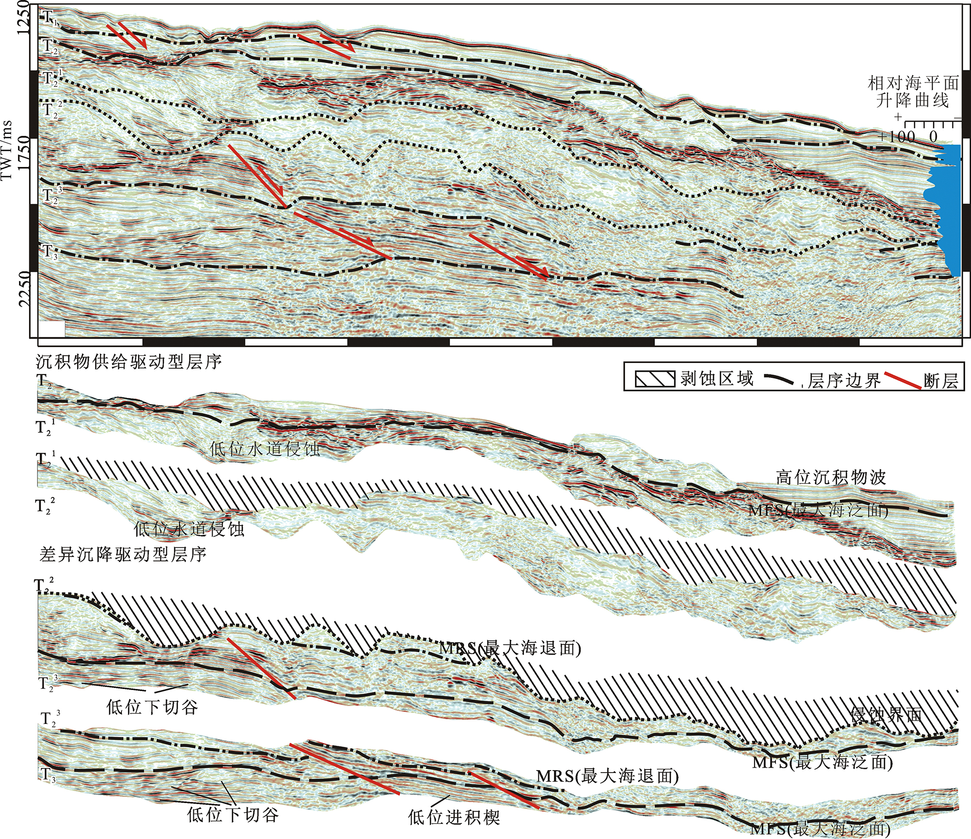
图5 峡谷区层序划分与解剖
Fig.5 Canyon stratigraphic division and seismic profile analysis

图6 峡谷层序参数定量统计
Fig.6 Quantitative statistics of the stratigraphic sedimentary parameters in the canyon

图7 两种类型层序演化模式
Fig.7 Two evolution patterns of stratigraphic evolution
| 物源驱动型层序演化模式 | 沉降驱动型层序演化模式 | |
|---|---|---|
| 体系域组成 | 低位域+海侵域+高位域 | 低位域+海侵域+高位域+海退域 |
| 海平面变化幅度 | 海平面变化明显(层序Ⅳ)、海平面变化不明显(层序Ⅲ)同时存在 | 海平面变化不明显(层序Ⅴ和层序Ⅳ) |
| 层序界面 | 具有明显的峡谷侵蚀界面作为初始洪泛面(FS);最大海泛面(MFS)反射较弱,但连续性强 | 具有较明显的峡谷侵蚀界面作为初始洪泛面(FS);最大海泛面(MFS)反射较强,中部有明显错断;海泛面上部发育较为整齐的前积体底界面为最大海退面(MRS) |
| 主控因素 | 物源供给、海平面变化、气候 | 物源供给、海平面变化、气候,基底构造运动 |
| 沉积单元 | 斜坡扇、盆地扇(低位域);沉积物波,水道体系(高位域和海侵域) | 斜坡扇、海底扇(低位域);沉积物波,水道体系、斜坡扇(高位域和海侵域) |
| 识别标志 | 同相轴内部连续性较好,顶部有明显的峡谷侵蚀 | 同相轴内部存在明显错断,侵蚀面上下均可见整齐同相轴前积 |
表1 两种类型层序的结构差异与识别标志
Table 1 Two stratigraphic patterns and their distinguishing indicators
| 物源驱动型层序演化模式 | 沉降驱动型层序演化模式 | |
|---|---|---|
| 体系域组成 | 低位域+海侵域+高位域 | 低位域+海侵域+高位域+海退域 |
| 海平面变化幅度 | 海平面变化明显(层序Ⅳ)、海平面变化不明显(层序Ⅲ)同时存在 | 海平面变化不明显(层序Ⅴ和层序Ⅳ) |
| 层序界面 | 具有明显的峡谷侵蚀界面作为初始洪泛面(FS);最大海泛面(MFS)反射较弱,但连续性强 | 具有较明显的峡谷侵蚀界面作为初始洪泛面(FS);最大海泛面(MFS)反射较强,中部有明显错断;海泛面上部发育较为整齐的前积体底界面为最大海退面(MRS) |
| 主控因素 | 物源供给、海平面变化、气候 | 物源供给、海平面变化、气候,基底构造运动 |
| 沉积单元 | 斜坡扇、盆地扇(低位域);沉积物波,水道体系(高位域和海侵域) | 斜坡扇、海底扇(低位域);沉积物波,水道体系、斜坡扇(高位域和海侵域) |
| 识别标志 | 同相轴内部连续性较好,顶部有明显的峡谷侵蚀 | 同相轴内部存在明显错断,侵蚀面上下均可见整齐同相轴前积 |

图8 古地貌对层序演化的控制作用
Fig.8 Controls of paleo-geomorphology on stratigraphic evolution
| [1] | 苏新, 陈芳, 于兴河, 等. 南海陆坡中新世以来沉积物特性与气体水合物分布初探[J]. 现代地质, 2005, 19(1):1-13. |
| [2] | 沙志彬, 梁金强, 苏丕波, 等. 珠江口盆地东部海域天然气水合物钻探结果及其成藏要素研究[J]. 地学前缘, 2015, 27(6): 125-135. |
| [3] |
于兴河, 王建忠, 梁金强, 等. 南海北部陆坡天然气水合物沉积成藏特征[J]. 石油学报, 2014, 35(2): 253-264.
DOI |
| [4] |
CATUNEANU O, ABREU V, BHATTACHARYA J P, et al. Towards the standardization of sequence stratigraphy[J]. Earth-Science Reviews, 2009, 92(1/2): 1-33.
DOI URL |
| [5] |
DI CELMA C, CANTALAMESSA G, DIDASKALOU P, et al. Sedimentology, architecture, and sequence stratigraphy of coarse-grained, submarine canyon fills from the Pleistocene (Gelasian-Calabrian) of the Peri-Adriatic basin, central Italy[J]. Marine and Petroleum Geology, 2010, 27(7): 1340-1365.
DOI URL |
| [6] | 邓宏文, 郭建宇, 王瑞菊, 等. 陆相断陷盆地的构造层序地层分析[J]. 地学前缘, 2008, 15(2): 1-7. |
| [7] |
OLABODE S O, ADEKOYA J A. Seismic stratigraphy and development of Avon canyon in Benin (Dahomey) basin, southwestern Nigeria[J]. Journal of African Earth Sciences, 2008, 50(5): 286-304.
DOI URL |
| [8] |
BERTON F, VESELY F F. Stratigraphic evolution of Eocene clinoforms from northern Santos Basin, offshore Brazil: Evaluating controlling factors on shelf-margin growth and deep-water sedimentation[J]. Marine and Petroleum Geology, 2016, 78: 356-372.
DOI URL |
| [9] |
NEAL J E, ABREU V, BOHACS K M, et al. Accommodation succession (δA /δS) sequence stratigraphy: observational method, utility and insights into sequence boundary formation[J]. Journal of the Geological Society, 2016, 173(5): 803-816.
DOI URL |
| [10] |
HEEZEN B C. Dynamic processes of abyssal sedimentation: Erosion, transportation, and redeposition on the deep-sea floor[J]. Geophysical Journal International, 1959, 2(2): 142-172.
DOI URL |
| [11] |
HAN J, XU G, LI Y, et al. Evolutionary history and controlling factors of the shelf breaks in the Pearl River Mouth Basin, northern South China Sea[J]. Marine and Petroleum Geology, 2016, 77: 179-189.
DOI URL |
| [12] |
解习农, 任建业, 王振峰, 等. 南海大陆边缘盆地构造演化差异性及其与南海扩张耦合关系[J]. 地学前缘, 2015, 22(1): 77-87.
DOI |
| [13] | 栾锡武, 彭学超, 邱燕. 南海北部陆坡高速堆积体的构造成因[J]. 现代地质, 2009, 23(2):183-199. |
| [14] | 苏明, 沙志彬, 乔少华, 等. 南海北部神狐海域天然气水合物钻探区第四纪以来的沉积演化特征[J]. 地球物理学报, 2015, 58(8): 2975-2985. |
| [15] |
HAQ B U, HARDENBOL J, VAIL P R. Chronology of fluctuating sea levels since the Triassic[J]. Science, 1987, 235: 1156-1167.
PMID |
| [16] |
HAN J, XU G, LI Y, et al. Evolutionary history and controlling factors of the shelf breaks in the Pearl River Mouth Basin, northern South China Sea[J]. Marine and Petroleum Geology, 2016, 77: 179-189.
DOI URL |
| [17] | 陈芳, 周洋, 苏新, 等. 南海神狐海域含水合物层粒度变化及与水合物饱和度的关系[J]. 海洋地质与第四纪地质, 2011, 31(5): 95-100. |
| [18] |
WANG X, COLLETT T S, LEE M W, et al. Geological controls on the occurrence of gas hydrate from core, downhole log, and seismic data in the Shenhu area, South China Sea[J]. Marine Geology, 2014, 357: 272-292.
DOI URL |
| [19] |
CLIFT P D, BRUNE S, QUINTEROS J. Climate changes control offshore crustal structure at South China Sea continental margin[J]. Earth and Planetary Science Letters, 2015, 420: 66-72.
DOI URL |
| [20] |
SCHWARZACHER W. Repetitions and cycles in stratigraphy[J]. Earth-Science Reviews, 2000, 50(1): 51-75.
DOI URL |
| [21] | VAIL P R. The stratigraphic signatures of tectonics, eustacy and sedimentology[J]. Cycles & Events in Stratigraphy, 1964, 123(1): 38-41. |
| [22] |
DEPTUCK M E, STEFFENS G S, BARTON M, et al. Architecture and evolution of upper fan channel-belts on the Niger Delta slope and in the Arabian Sea[J]. Marine and Petroleum Geology, 2003, 20(6): 649-676.
DOI URL |
| [23] |
DEPTUCK M E, SYLVESTER Z, PIRMEZ C, et al. Migration-aggradation history and 3-D seismic geomorphology of submarine channels in the Pleistocene Benin-major Canyon, western Niger Delta slope[J]. Marine and Petroleum Geology, 2007, 24(6/9): 406-433.
DOI URL |
| [24] |
FONNESU F. 3D seismic images of a low-sinuosity slope channel and related depositional lobe (West Africa deep-offshore)[J]. Marine and Petroleum Geology, 2003, 20(6/8): 615-629.
DOI URL |
| [25] | 李磊, 王英民, 徐强, 等. 南海北部白云凹陷21Ma深水重力流沉积体系[J]. 石油学报, 2012, 33(5): 798-806. |
| [26] |
MALLARINO G, BEAUBOUEF R T, DROXLER A W, et al. Sea level influence on the nature and timing of a minibasin sedimentary fill (northwestern slope of the Gulf of Mexico)[J]. AAPG Bulletin, 2006, 90(7): 1089-1119.
DOI URL |
| [27] |
MUTO T, STEEL R J. Role of autoretreat and A/S changes in the understanding of deltaic shoreline trajectory: a semi-quantitative approach[J]. Basin Research, 2002, 14(3): 303-318.
DOI URL |
| [28] | XU S H, WANG Y M, XU G Q, et al. Linking shelf delta to deep-marine deposition in reservoir dispersal of the upper Oligocene strata in the Baiyun Sag, the northern South China Sea[J]. Australian Journal of Earth Sciences, 2015, 62(3): 365-382. |
| [29] |
YU X, WANG J, LIANG J, et al. Depositional characteristics and accumulation model of gas hydrates in northern South China Sea[J]. Marine and Petroleum Geology, 2014, 56(3): 74-86.
DOI URL |
| [30] |
LIAO J, ZHOU D, ZHAO Z X, et al. Numerical modeling of the anomalous post-rift subsidence in the Baiyun Sag, Pearl River Mouth Basin[J]. Science China Earth Sciences, 2011, 54(8): 1156-1167.
DOI URL |
| [31] |
GONG C, WANG Y, ZHENG R, et al. Middle Miocene reworked turbidites in the Baiyun Sag of the Pearl River Mouth Basin, northern South China Sea margin: Processes, genesis, and implications[J]. Journal of Asian Earth Sciences, 2016, 128: 116-129.
DOI URL |
| [32] |
YUAN S, WU S, THOMAS L, et al. Fine-grained Pleistocene deepwater turbidite channel system on the slope of Qiongdongnan Basin, northern South China Sea[J]. Marine and Petroleum Geology, 2009, 26(8): 1441-1451.
DOI URL |
| [33] |
CLARK I R, CARTWRIGHT J A. Key controls on submarine channel development in structurally active settings[J]. Marine and Petroleum Geology, 2011, 28(7): 1333-1349.
DOI URL |
| [34] |
SALLER A, DHARMASAMADHI I N W. Controls on the development of valleys, canyons, and unconfined channel-levee complexes on the Pleistocene Slope of East Kalimantan, Indonesia[J]. Marine and Petroleum Geology, 2012, 29(1): 15-34.
DOI URL |
| [35] |
ESCHARD R. Geological factors controlling sediment transport from platform to deep basin: a review[J]. Marine and Petroleum Geology, 2001, 18(4): 487-490.
DOI URL |
| [36] |
张莉, 曾维军, 韦振权, 等. 南海北部古构造格局对中、新生界发育的影响[J]. 地学前缘, 2014, 21(6): 254-263.
DOI |
| [37] |
彭大钧, 陈长民, 庞雄, 等. 南海珠江口盆地深水扇系统的发现[J]. 石油学报, 2004, 25(5): 17-23.
DOI |
| [1] | 张保涛, 梅贞华, 李秀章, 姜晓平, 胡兆国, 王小玉, 赵晓博, 胡加斌, 柳森. 华北克拉通矽卡岩型富铁矿成矿关键控制因素:来自地层学的制约[J]. 现代地质, 2024, 38(01): 98-116. |
| [2] | 刘旺威, 李一凡, 高志前, 樊太亮, 张坦, 匡明志. 塔里木盆地东北缘下寒武统页岩岩相特征与沉积模式[J]. 现代地质, 2023, 37(05): 1155-1168. |
| [3] | 倪敏婕, 祝贺暄, 何文军, 杨森, 邹阳, 张元元. 准噶尔盆地玛湖凹陷风城组沉积环境与沉积模式分析[J]. 现代地质, 2023, 37(05): 1194-1207. |
| [4] | 束青林, 赵辉, 姜在兴, 赵国光. 渤海湾盆地惠民凹陷商河地区古近系沙四上亚段滩坝沉积特征[J]. 现代地质, 2023, 37(05): 1232-1242. |
| [5] | 王续学, 张祥玉, 李守军, 张家豪, 张振宇. 莱阳凹陷莱阳群黑色页岩氧化还原敏感微量元素特征与有机质富集的控制因素[J]. 现代地质, 2023, 37(03): 733-744. |
| [6] | 孙遥, 郭峰, 彭晓霞, 向佳, 张磊, 杨旭东. 曲流河相储层特征及其主控因素分析:以鄂尔多斯盆地胡尖山油田延9为例[J]. 现代地质, 2022, 36(05): 1403-1413. |
| [7] | 胡高伟, 吴能友, 李琦, 白辰阳, 万义钊, 黄丽, 王代刚, 李彦龙, 陈强. 海域天然气水合物试采目标优选定量评价方法初探[J]. 现代地质, 2022, 36(01): 202-211. |
| [8] | 李燕, 邓运华, 李友川. 河流-三角洲体系微相控烃及机理研究:以珠江口盆地恩平组煤系烃源岩为例[J]. 现代地质, 2021, 35(04): 1065-1077. |
| [9] | 贾鹏, 黄福喜, 林世国, 宋涛, 高阳, 吕维宁, 汪少勇, 刘策, 范晶晶, 欧阳靖琳. 四川盆地及其邻区中上寒武统洗象池群沉积相与沉积模式特征研究[J]. 现代地质, 2021, 35(03): 807-818. |
| [10] | 杨志忠, 周文龙, 罗勇军, 蒲庆隆, 令狐东, 宋小军. 贵州镇远县耕地土壤中硒的分布特征及控制因素[J]. 现代地质, 2021, 35(02): 434-442. |
| [11] | 王旭影, 姜在兴. 苏北盆地古近系阜三段沉积体系特征与模式[J]. 现代地质, 2020, 34(06): 1132-1143. |
| [12] | 袁坤, 金振奎, 彭飚, 朱小二, 田甜, 黎瑞. 青海湖东南岸现代滩坝沉积模式与识别标志[J]. 现代地质, 2020, 34(02): 309-320. |
| [13] | 肖莎, 高志前. 广西东兰-凤山地区石炭纪-二叠纪碳酸盐岩洞穴发育特点及其控制因素[J]. 现代地质, 2019, 33(06): 1208-1219. |
| [14] | 汶锋刚, 朱玉双, 任战利, 高鹏鹏, 倪军, 王仙仙, 许维武, 马彬, 高明星, 洪千里. 鄂尔多斯盆地延长组长9小层致密砂岩含油性控制因素[J]. 现代地质, 2018, 32(01): 183-190. |
| [15] | 刘杰 ,孙美静,杨睿, 苏明, 严恒. 泥底辟输导流体机制及其与天然气水合物成藏的关系[J]. 现代地质, 2016, 30(6): 1399-1407. |
| 阅读次数 | ||||||
|
全文 |
|
|||||
|
摘要 |
|
|||||