

Geoscience ›› 2024, Vol. 38 ›› Issue (02): 451-463.DOI: 10.19657/j.geoscience.1000-8527.2023.090
• Hydrogeology, Engineering Geology and Environmental Geology • Previous Articles Next Articles
QIU Zhendong1,2,3( ), GUO Changbao1,3(), WU Rui’an1,3, JIAN Wenxing2, NI Jiawei1,3, ZHANG Ya’nan1,2,3, YAN Yiqiu1,3
Received:2023-04-07
Revised:2023-07-12
Online:2024-04-10
Published:2024-05-22
CLC Number:
QIU Zhendong, GUO Changbao, WU Rui’an, JIAN Wenxing, NI Jiawei, ZHANG Ya’nan, YAN Yiqiu. Development Characteristics and Stability Evaluation of the Shadingmai Large-scale Ancient Landslide in the Upper Reaches of Jinsha River, Tibetan Plateau[J]. Geoscience, 2024, 38(02): 451-463.

Fig.1 Regional structural geological map of the Tibetan Plateau (a) and regional geological map of the Shadingmai ancient landslide (b)

Fig.2 Geological map of the plane engineering of the Shadingmai ancient landslide

Fig.3 Spatial morphological characteristics of the Shadingmai ancient landslide

Fig.4 Spatial structure characteristics of the Shadingmai ancient landslide

Fig.5 Engineering geological section of the Shadingmai ancient landslide

Fig.6 Map of the InSAR deformation characteristics of the Shadingmai ancient landslide

Fig.7 Developmental characteristics of deformations and failures of the Shadingmai ancient landslide

Fig.8 Rainfall characteristics of the Shadingmai ancient landslide area

Fig.9 Numerical model and grid division of the Shadingmai ancient landslide
| 岩性 | 体积模量 (GPa) | 剪切模量 (GPa) | 密度 (g/cm3) | 天然工况 | 暴雨工况 | ||
|---|---|---|---|---|---|---|---|
| 黏聚力 (kPa) | 内摩擦角 (°) | 黏聚力 (kPa) | 内摩擦角 (°) | ||||
| 滑坡堆积体1 | 0.52 | 0.35 | 2.0 | 145 | 25 | 132 | 22 |
| 滑坡堆积体2 | 0.54 | 0.38 | 2.0 | 150 | 27 | 140 | 24 |
| 滑坡堆积体3 | 0.53 | 0.33 | 2.0 | 133 | 24 | 115 | 20 |
| 断裂带 | 10.00 | 5.00 | 2.1 | 350 | 38 | 300 | 35 |
| 滑带 | 0.30 | 0.26 | 1.9 | 28 | 23 | 18 | 19 |
| 板岩夹千枚岩 | 38.00 | 12.00 | 2.2 | 513 | 60 | 420 | 52 |
| 板岩 | 40.00 | 15.00 | 2.4 | 550 | 63 | 435 | 55 |
Table 1 Main parameters of the simulation calculation of the Shadingmai ancient landslide
| 岩性 | 体积模量 (GPa) | 剪切模量 (GPa) | 密度 (g/cm3) | 天然工况 | 暴雨工况 | ||
|---|---|---|---|---|---|---|---|
| 黏聚力 (kPa) | 内摩擦角 (°) | 黏聚力 (kPa) | 内摩擦角 (°) | ||||
| 滑坡堆积体1 | 0.52 | 0.35 | 2.0 | 145 | 25 | 132 | 22 |
| 滑坡堆积体2 | 0.54 | 0.38 | 2.0 | 150 | 27 | 140 | 24 |
| 滑坡堆积体3 | 0.53 | 0.33 | 2.0 | 133 | 24 | 115 | 20 |
| 断裂带 | 10.00 | 5.00 | 2.1 | 350 | 38 | 300 | 35 |
| 滑带 | 0.30 | 0.26 | 1.9 | 28 | 23 | 18 | 19 |
| 板岩夹千枚岩 | 38.00 | 12.00 | 2.2 | 513 | 60 | 420 | 52 |
| 板岩 | 40.00 | 15.00 | 2.4 | 550 | 63 | 435 | 55 |
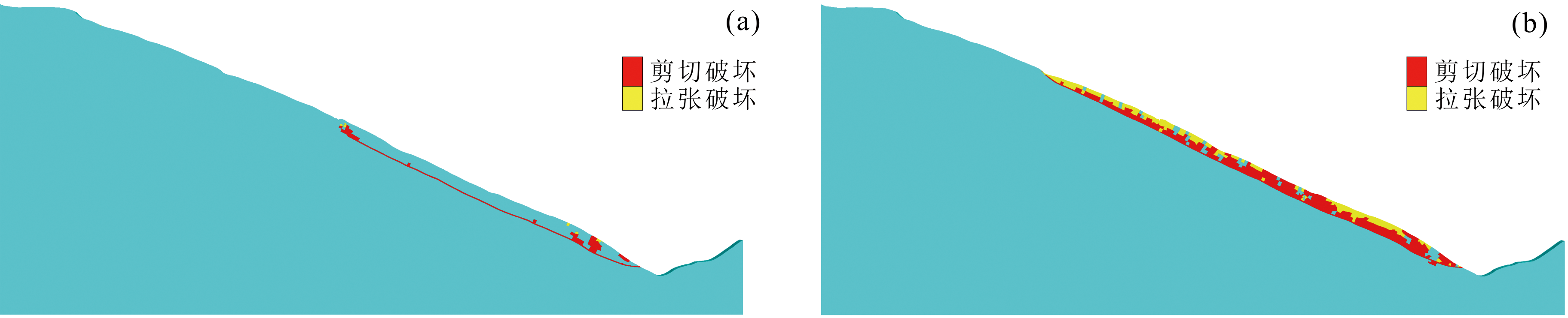
Fig.10 Plastic classification layout of the Shadingmai ancient landslide

Fig.11 Displacement contour plot and displacement vector of the Shadingmai ancient landslide

Fig.12 Time-step change of displacement at monitoring point of the Shadingmai ancient landslide
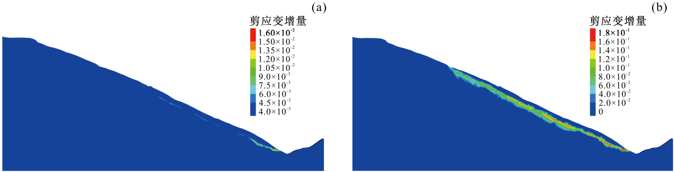
Fig.13 Shear strain increment contour plot of the Shadingmai ancient landslide
| [1] | 许志琴, 杨经绥, 姜枚, 等. 大陆俯冲作用及青藏高原周缘造山带的崛起[J]. 地学前缘, 1999, 6(3): 139-151. |
| [2] | 王思敬. 地球内外动力耦合作用与重大地质灾害的成因初探[J]. 工程地质学报, 2002, 10(2): 115-117. |
| [3] |
彭建兵, 马润勇, 卢全中, 等. 青藏高原隆升的地质灾害效应[J]. 地球科学进展, 2004, 19(3): 457-466.
DOI |
| [4] | 黄润秋. 20世纪以来中国的大型滑坡及其发生机制[J]. 岩石力学与工程学报, 2007, 26(3): 433-454. |
| [5] | 张永双, 郭长宝, 姚鑫, 等. 青藏高原东缘活动断裂地质灾害效应研究[J]. 地球学报, 2016, 37(3): 277-286. |
| [6] | 许强, 郑光, 李为乐, 等. 2018年10月和11月金沙江白格两次滑坡-堰塞堵江事件分析研究[J]. 工程地质学报, 2018, 26(6): 1534-1551. |
| [7] | 邓建辉, 高云建, 余志球, 等. 堰塞金沙江上游的白格滑坡形成机制与过程分析[J]. 工程科学与技术, 2019, 51(1): 9-16. |
| [8] | FAN X M, YANG F, SIVA SUBRAMANIAN S, et al. Prediction of a multi-hazard chain by an integrated numerical simulation approach: The Baige landslide, Jinsha River, China[J]. Landslides, 2020, 17(1): 147-164. |
| [9] | MEI S Y, CHEN S S, ZHONG Q M, et al. Detailed numerical modeling for breach hydrograph and morphology evolution during landslide dam breaching[J]. Landslides, 2022, 19(12): 2925-2949. |
| [10] | CHEN J, DAI F C, LV T Y, et al. Holocene landslide-dammed lake deposits in the Upper Jinsha River, SE Tibetan Plateau and their ages[J]. Quaternary International, 2013, 298: 107-113. |
| [11] | 邓建辉, 李化, 戴福初, 等. 金沙江上游超大古堰塞湖及其相关问题[J]. 工程科学与技术, 2022, 54(6): 75-84. |
| [12] | 郭长宝, 吴瑞安, 李雪, 等. 川西日扎潜在巨型岩质滑坡发育特征与形成机理研究[J]. 工程地质学报, 2020, 28(4): 772-783. |
| [13] | 刘威, 何思明. 金沙江沃达潜在滑坡诱发灾害链成灾过程数值模拟[J]. 工程科学与技术, 2020, 52(2): 38-46. |
| [14] | 吴瑞安, 马海善, 张俊才, 等. 金沙江上游沃达滑坡发育特征与堵江危险性分析[J]. 水文地质工程地质, 2021, 48(5): 120-128. |
| [15] | OUYANG C J, AN H C, ZHOU S, et al. Insights from the failure and dynamic characteristics of two sequential landslides at Baige Village along the Jinsha River, China[J]. Landslides, 2019, 16(7): 1397-1414. |
| [16] | 张永双, 巴仁基, 任三绍, 等. 中国西藏金沙江白格滑坡的地质成因分析[J]. 中国地质, 2020, 47(6): 1637-1645. |
| [17] | ZHANG S L, YIN Y P, HU X W, et al. Geo-structures and deformation-failure characteristics of rockslide areas near the Baige landslide scar in the Jinsha River tectonic suture zone[J]. Landslides, 2021, 18(11): 3577-3597. |
| [18] | 朱德明, 李鹏岳, 胡孝洪, 等. 金沙江白格滑坡残留体稳定性分析与防治对策[J]. 现代地质, 2021, 35(1): 56-63. |
| [19] | 许志琴, 侯立玮, 王宗秀, 等. 中国松潘—甘孜造山带的造山过程[M]. 北京: 地质出版社, 1992. |
| [20] | 夏金梧, 朱萌. 金沙江主断裂带中段构造特征与活动性研究[J]. 人民长江, 2020, 51(5): 131-137, 159. |
| [21] | 全国地震标准化技术委员会. 中国地震动参数区划图GB 18306—2015[S]. 北京: 中国标准出版社, 2016. |
| [22] | 伍先国, 蔡长星. 金沙江断裂带新活动和巴塘6.5级地震震中的确定[J]. 地震研究, 1992, 15(4): 401-410. |
| [23] | 周荣军, 陈国星, 李勇, 等. 四川西部理塘—巴塘地区的活动断裂与1989年巴塘6.7级震群发震构造研究[J]. 地震地质, 2005, 27(1): 31-43. |
| [24] | 曹鹏. 藏东白格高位滑坡形成机制及稳定性研究[D]. 昆明: 昆明理工大学, 2021. |
| [25] |
朱建军, 李志伟, 胡俊. InSAR变形监测方法与研究进展[J]. 测绘学报, 2017, 46(10): 1717-1733.
DOI |
| [26] |
张艳梅, 王萍, 罗想, 等. 利用Sentinel-1数据和SBAS-InSAR技术监测西安地表沉降[J]. 测绘通报, 2017(4): 93-97.
DOI |
| [27] | WASOWSKI J, BOVENGA F. Investigating landslides and unstable slopes with satellite Multi Temporal Interferometry: Current issues and future perspectives[J]. Engineering Geology, 2014, 174: 103-138. |
| [28] | FERRETTI A, PRATI C, ROCCA F. Nonlinear subsidence rate estimation using permanent scatterers in differential SAR interferometry[J]. IEEE Transactions on Geoscience and Remote Sensing, 2000, 38(5): 2202-2212. |
| [29] | LANARI R, MORA O, MANUNTA M, et al. A small-baseline approach for investigating deformations on full-resolution differential SAR interferograms[J]. IEEE Transactions on Geoscience and Remote Sensing, 2004, 42(7): 1377-1386. |
| [30] | 谢守益, 徐卫亚. 降雨诱发滑坡机制研究[J]. 武汉水利电力大学学报, 1999, 32(1): 22-24. |
| [31] | 姚贺冬, 石崇, 徐卫亚, 等. 古水水电站争岗堆积体滑坡复活条件分析[J]. 河海大学学报(自然科学版), 2015, 43(1): 28-33. |
| [32] | GUO C B, ZHANG Y S, LI X, et al. Reactivation of giant Jiangdingya ancient landslide in Zhouqu County, Gansu Province, China[J]. Landslides, 2020, 17(1): 179-190. |
| [33] | 郭长宝, 任三绍, 李雪, 等. 甘肃舟曲南峪江顶崖古滑坡发育特征与复活机理[J]. 现代地质, 2019, 33(1): 206-217. |
| [34] | 杨校辉, 强远文, 王宏睿, 等. 甘肃舟曲滑坡成因机制与发育分布规律[J/OL]. 现代地质: 1-9 [2023-04-16]. https://doi.org/10.19657/j.geoscience.1000-8527.2023.018. |
| [35] | 王立朝, 温铭生, 冯振, 等. 中国西藏金沙江白格滑坡灾害研究[J]. 中国地质灾害与防治学报, 2019, 30(1): 1-9. |
| [36] | 郭长宝, 闫怡秋, 张永双, 等. 青藏高原大型深层蠕滑型滑坡变形机制研究进展与展望[J]. 地球科学, 2022, 47(10): 3677-3700. |
| [37] | 杨连伟. 金沙江白格滑坡失稳机理及影响因素分析[J]. 人民长江, 2023, 54(1): 119-125, 176. |
| [38] | 赵尚毅, 郑颖人, 时卫民, 等. 用有限元强度折减法求边坡稳定安全系数[J]. 岩土工程学报, 2002, 24(3): 343-346. |
| [39] | 栾茂田, 武亚军, 年廷凯. 强度折减有限元法中边坡失稳的塑性区判据及其应用[J]. 防灾减灾工程学报, 2003, 23(3): 1-8. |
| [40] | 陈育民, 徐鼎平. FLAC/FLAC3D基础与工程实例[M]. 2版. 北京: 中国水利水电出版社, 2013. |
| [41] | 全国国土资源标准化技术委员会. 滑坡防治工程勘查规范GB/T 32864—2016[S]. 北京: 中国标准出版社, 2016. |
| [42] | KHARIN V V, ZWIERS F W, ZHANG X, et al. Changes in temperature and precipitation extremes in the CMIP5 ensemble[J]. Climatic Change, 2013, 119(2): 345-357. |
| [43] | WESTRA S, FOWLER H J, EVANS J P, et al. Future changes to the intensity and frequency of short-duration extreme rainfall[J]. Reviews of Geophysics, 2014, 52(3): 522-555. |
| Viewed | ||||||
|
Full text |
|
|||||
|
Abstract |
|
|||||