

Geoscience ›› 2022, Vol. 36 ›› Issue (05): 1371-1381.DOI: 10.19657/j.geoscience.1000-8527.2022.060
• Hydrocarbon Geological Evaluation • Previous Articles Next Articles
ZHAO Yongqiang1,2( ), SU Siyu3,4, PU Renhai3,4(), YAO Wei1,2, JI Tianyu5
Received:2022-01-30
Revised:2022-06-26
Online:2022-10-10
Published:2022-11-03
Contact:
PU Renhai
CLC Number:
ZHAO Yongqiang, SU Siyu, PU Renhai, YAO Wei, JI Tianyu. Identification and Distribution of Carboniferous Coal Measure Source Rocks in the Bamai Area, Southwestern Tarim Basin[J]. Geoscience, 2022, 36(05): 1371-1381.

Fig.1 Tectonic unit division map of Bamai area (a) and Upper Carboniferous to Lower Permian comprehensive histogram in Bamai area (b)

Fig.2 Comprehensive stratigraphic profile of Carboniferous Karashayi Formation of well BT5
| 样品编号 | 钻井 | 代号 | 地层 | 来源 | 深度/m | 岩性 | Tmax/℃ | TOC/% | Ro/% | 有机碳类型 |
|---|---|---|---|---|---|---|---|---|---|---|
| 1 | BT5 | C1k | 砂泥岩段 | 岩心 | 1 918.1 | 炭质泥岩 | 437 | 14.20 | 1.65 | Ⅲ |
| 2 | BT5 | C1k | 砂泥岩段 | 岩心 | 1 917.6 | 泥岩 | 434 | 0.15 | 0.90 | Ⅲ |
| 3 | KT1 | C1k | 砂泥岩段 | 岩屑 | 1 620 | 炭质泥岩 | 431 | 14.40 | 0.78 | Ⅱ2 |
| 4 | BT5 | C1k | 砂泥岩段 | 岩屑 | 2 040 | 炭质泥岩 | 424 | 10.60 | 0.78 | Ⅱ2-Ⅲ |
| 5 | BT10 | C1b | 下泥岩段 | 岩屑 | 2 660 | 泥岩 | 436 | 0.01 | 0.80 | Ⅲ |
| 6 | BT7 | C1k | 砂泥岩段 | 岩屑 | 4 520 | 泥岩 | 431 | 0.01 | 0.97 | Ⅲ |
| 7 | BT7 | C1k | 砂泥岩段 | 岩屑 | 4 540 | 泥岩 | 428 | 0.86 | 1.33 | Ⅲ |
| 8 | BT9 | C1k | 砂泥岩段 | 岩屑 | 4 740 | 泥岩 | 437 | 1.15 | 1.13 | Ⅲ |
| 9 | BT5 | C1k | 含灰岩段 | 岩屑 | 2 020 | 泥岩 | 428 | 2.36 | 0.87 | Ⅲ |
| 10 | BT5 | C1k | 砂泥岩段 | 岩屑 | 2 095 | 泥岩 | 432 | 0.94 | 0.80 | Ⅲ |
| 11 | BT5 | C1b | 中(膏)泥岩段 | 岩屑 | 2 400 | 泥岩 | 429 | 0.15 | — | Ⅲ |
| 12 | BT5 | C1k | 砂泥岩段 | 岩屑 | 2 055 | 煤 | 425 | 58.10 | 1.29 | Ⅱ1-Ⅱ2 |
| 13 | BT5 | C1k | 砂泥岩段 | 岩屑 | 2 060 | 炭质泥岩 | 424 | 18.50 | 0.81 | Ⅱ2 |
| 14 | KT1 | C1k | 砂泥岩段 | 岩屑 | 1 605 | 煤 | 432 | 63.20 | 0.93 | Ⅲ |
Table 1 Determination results of TOC content, Ro and organic carbon types of different lithology in the study area
| 样品编号 | 钻井 | 代号 | 地层 | 来源 | 深度/m | 岩性 | Tmax/℃ | TOC/% | Ro/% | 有机碳类型 |
|---|---|---|---|---|---|---|---|---|---|---|
| 1 | BT5 | C1k | 砂泥岩段 | 岩心 | 1 918.1 | 炭质泥岩 | 437 | 14.20 | 1.65 | Ⅲ |
| 2 | BT5 | C1k | 砂泥岩段 | 岩心 | 1 917.6 | 泥岩 | 434 | 0.15 | 0.90 | Ⅲ |
| 3 | KT1 | C1k | 砂泥岩段 | 岩屑 | 1 620 | 炭质泥岩 | 431 | 14.40 | 0.78 | Ⅱ2 |
| 4 | BT5 | C1k | 砂泥岩段 | 岩屑 | 2 040 | 炭质泥岩 | 424 | 10.60 | 0.78 | Ⅱ2-Ⅲ |
| 5 | BT10 | C1b | 下泥岩段 | 岩屑 | 2 660 | 泥岩 | 436 | 0.01 | 0.80 | Ⅲ |
| 6 | BT7 | C1k | 砂泥岩段 | 岩屑 | 4 520 | 泥岩 | 431 | 0.01 | 0.97 | Ⅲ |
| 7 | BT7 | C1k | 砂泥岩段 | 岩屑 | 4 540 | 泥岩 | 428 | 0.86 | 1.33 | Ⅲ |
| 8 | BT9 | C1k | 砂泥岩段 | 岩屑 | 4 740 | 泥岩 | 437 | 1.15 | 1.13 | Ⅲ |
| 9 | BT5 | C1k | 含灰岩段 | 岩屑 | 2 020 | 泥岩 | 428 | 2.36 | 0.87 | Ⅲ |
| 10 | BT5 | C1k | 砂泥岩段 | 岩屑 | 2 095 | 泥岩 | 432 | 0.94 | 0.80 | Ⅲ |
| 11 | BT5 | C1b | 中(膏)泥岩段 | 岩屑 | 2 400 | 泥岩 | 429 | 0.15 | — | Ⅲ |
| 12 | BT5 | C1k | 砂泥岩段 | 岩屑 | 2 055 | 煤 | 425 | 58.10 | 1.29 | Ⅱ1-Ⅱ2 |
| 13 | BT5 | C1k | 砂泥岩段 | 岩屑 | 2 060 | 炭质泥岩 | 424 | 18.50 | 0.81 | Ⅱ2 |
| 14 | KT1 | C1k | 砂泥岩段 | 岩屑 | 1 605 | 煤 | 432 | 63.20 | 0.93 | Ⅲ |

Fig.3 KT1-BT5-BT10 well linked cross-section in Bachu Formation (seeing Fig.1 for the well locations)

Fig.4 Contour map of coal vitrinite reflectance of the top Carboniferous Kalashayi Formation in Bamai area

Fig.5 Crossplots of AC-GR and RD-DEN logging values of different lithology of Kalashayi Formation in southwest Tarim Basin

Fig.6 Percentage diagram of coal measure source rocks in Kalashayi Formation with wave impedance less than the threshold in BT5 three-dimension seismic area
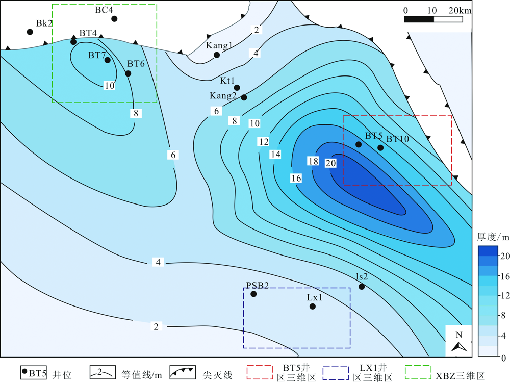
Fig.7 Isopach map of cumulative thickness of Carboniferous coal seam and Carbonaceous mudstone in Bamai area

Fig.8 Seismic section of NW-SE orientation delta progradational reflection of Karasayi Formation through BT5-BT10 well (seeing Fig.6 for section location)

Fig.9 Superposition distribution map of five-stage progradational reflections (filled with semi-translucent color)

Fig.10 Depositional facies map of Carboniferous Kalashayi Formation in Bamai area
| [1] | 李勇, 许卫凯, 高计县, 等. “源-储-输导系统”联控煤系气富集成藏机制--以鄂尔多斯盆地东缘为例[J]. 煤炭学报, 2021, 46(8): 2440-2453. |
| [2] | 李勇, 王延斌, 孟尚志, 等. 煤系非常规天然气合采地质基础理论进展及展望[J]. 煤炭学报, 2020, 45(4): 1406-1418. |
| [3] | ZHANG Kang, WANG Darui. Tectonics and prospects of oil and gas in Tarim Basin[J]. AAPG Bulletin, 1996, 80: 1. |
| [4] | 佘晓宇, 施泽进, 刘高波. 巴楚-麦盖提地区油气成藏的输导系统[J]. 石油与天然气地质, 2003, 24(4): 346-350. |
| [5] | 高志农. 塔里木盆地巴楚隆起烃源岩特征及其油气源研究[J]. 石油实验地质, 2000, 22(4): 319-324. |
| [6] |
MI Jingkui, ZHANG Shuichang, CHEN Jianping, et al. The distribution of the oil derived from Cambrian source rocks in Lunnan area,the Tarim Basin,China[J]. Chinese Science Bulletin, 2007, 52(1): 133-140.
DOI URL |
| [7] | 金之钧. 从源-盖控烃看塔里木台盆区油气分布规律[J]. 石油与天然气地质, 2014, 35(6): 763-770. |
| [8] | 丁勇, 宫继萍, 王辉. 塔里木盆地西南坳陷生油岩综合评价[J]. 石油实验地质, 1999, 21(4): 336-339. |
| [9] | 李士超. 塔里木盆地西南地区石炭-二叠系沉积特征与烃源岩评价[D]. 北京: 中国地质大学(北京), 2011. |
| [10] | 李世臻, 康志宏, 邱海峻, 等. 塔里木盆地西南坳陷油气成藏模式[J]. 中国地质, 2014, 41(2): 387-398. |
| [11] | 李京昌, 吴疆, 何宏, 等. 塔里木盆地石炭系卡拉沙依组烃源岩研究[J]. 石油实验地质, 2017, 39(4): 511-519. |
| [12] | 马庆佑, 吕海涛, 蒋华山, 等. 塔里木盆地台盆区构造单元划分方案[J]. 海相油气地质, 2015, 20(1): 1-9. |
| [13] |
QIU Nansheng, JIANG Guang, MEI Qinghua, et al. Tectono-thermal evolution in the Bachu uplift, Tarim Basin, China[J]. Acta Geologica Sinica, 2010, 84(5): 1286-1293.
DOI URL |
| [14] | 张光亚, 赵文智, 王红军, 等. 塔里木盆地多旋回构造演化与复合含油气系统[J]. 石油与天然气地质, 2007, 28(5): 653-663. |
| [15] | 黄太柱, 蒋华山, 马庆佑. 塔里木盆地下古生界碳酸盐岩油气成藏特征[J]. 石油与天然气地质, 2014, 35(6): 780-787. |
| [16] |
LIN Changsong, YANG Haijun, LIU Jingyan, et al. Paleostructural geomorphology of the Paleozoic central uplift belt and its constraint on the development of depositional facies in the Tarim Basin[J]. Science China Earth Sciences, 2009, 52(6): 823-834.
DOI URL |
| [17] | 许璟, 蒲仁海, 杨林, 等. 塔里木盆地石炭系泥岩沉积时的古盐度分析[J]. 沉积学报, 2010, 28(3): 509-517. |
| [18] |
WU Xiaoqi, TAO Xiaowan, HU Guoyi. Geochemical characteristics and source of natural gases from Southwest Depression of the Tarim Basin, NW China[J]. Organic Geochemistry, 2014, 74: 106-115.
DOI URL |
| [19] | 魏国齐, 杨威, 李剑, 等. 中国陆上天然气地质特征与勘探领域[J]. 天然气地球科学, 2014, 25(7): 957-970. |
| [20] |
PANG Xiongqi, CHEN Junqing, LI Sumei, et al. Evaluation method and application of the relative contribution of marine hydrocarbon source rocks in the Tarim basin: A case study from the Tazhong area[J]. Marine and Petroleum Geology, 2016, 77: 1-18.
DOI URL |
| [21] |
ZHANG Shuichang, GAO Zhiyong, LI Jianjun, et al. Identification and distribution of marine hydrocarbon source rocks in the Ordovician and Cambrian of the Tarim Basin[J]. Petroleum Exploration and Development, 2012, 39(3): 305-314.
DOI URL |
| [22] | 刘占红, 陈荣, 宋成兵, 等. 塔里木盆地石炭系卡拉沙依组旋回地层与层序地层综合研究[J]. 地球科学--中国地质大学学报, 2012, 37(5): 1051-1065. |
| [23] | MUKHOPADHYAY PRASANTA K, WADE JOHN A, KRUGE MICHAEL A. Organic facies and maturation of Jurassic/Cretaceous rocks, and possible oil-source rock correlation based on pyrolysis of asphaltenes, Scotian Basin, Canada[J]. Organic Geochemistry, 1995, 29(4): 490-497. |
| [24] | 许怀先. 石油地质实验测试技术与应用[M]. 北京: 石油工业出版社, 2001. |
| [25] | 卢双舫. 油气地球化学[M]. 北京: 石油工业出版社, 2008. |
| [26] | 蒲仁海. 前积反射的地质解释[J]. 石油地球物理勘探, 1994, 29(4): 490-497. |
| [1] | WANG Jiaxin, HOU Qingye, YE Danjun, YANG Zhongfang, YU Tao. Differences of Cadmium Mobility in Paddy Soils from Different Parent Materials in the Pearl River Delta and Its Influencing Factors [J]. Geoscience, 2023, 37(01): 197-207. |
| [2] | ZHANG Jinqing, LI Xianqing, ZHANG Boxiang, ZHANG Xueqing, YANG Jingwei, YU Zhenfeng. Pore Characteristics and Pore Structure of the Upper Paleozoic Coal-bearing Shale Gas Reservoir in the Wuxiang Block, Qinshui Basin [J]. Geoscience, 2022, 36(06): 1551-1562. |
| [3] | LI Erting, MA Wanyun, LI Ji, MA Xinxing, PAN Changchun, ZENG Lifei, WANG Ming. Thermal Simulation Experiment for Hydrocarbon Generation: A Case Study of Jurassic Coal from the Southern Margin of Junggar Basin [J]. Geoscience, 2022, 36(05): 1313-1323. |
| [4] | WEI Yongheng, GE Yanyan, WANG Gang, WANG Wenfeng, TIAN Jijun, LI Xin, WU Bin, ZHANG Xiao. In-situ Stress Distribution and Its Influence on Coalbed Methane Development in Tielieke Mining Area, Kubai Coalfield, Xinjiang [J]. Geoscience, 2022, 36(05): 1324-1332. |
| [5] | ZHAI Jiayu, ZHANG Songhang, TANG Shuheng, GUO Huiqiu, LIU Bing, JI Chaoqi. Origin and Productivity Response of Gas and Water in Coalbed Methane Field of Yuwang Block at Laochang, Yunnan Province [J]. Geoscience, 2022, 36(05): 1341-1350. |
| [6] | LI Jinlong, LI Qian, CAI Yidong, CHEN Wei, CHEN Zhizhu, WANG Jian, XUE Xiaohui. Geological Conditions and Resource Potential of Coalbed Methane Reservoirs in Laochang Mining Area, Yunnan Province [J]. Geoscience, 2022, 36(05): 1351-1359. |
| [7] | YAN Taotao, GUO Yilin, MENG Yanjun, CHANG Suoliang, JIN Shangwen, KANG Lifang, FU Xinyu, WANG Qingqing, ZHAO Yuan, ZHANG Yu. Coal Reservoir Gas Content Correction Based on Coalbed Methane Well Production Data [J]. Geoscience, 2022, 36(05): 1360-1370. |
| [8] | WANG Zhenzhen, LI Jinxiao, ZHANG Ke, GUO Wenmu, ZHANG Shaowei, XIAO Lin. Geochemical Characteristics of Rare Earth Elements and the Indicative Significance in the Ximing Coal Mine, Shanxi Province [J]. Geoscience, 2021, 35(04): 1009-1017. |
| [9] | YUAN Hao, LIU Jiapeng, JIANG Zaixing. 4D Seismic Characteristics in Coal Mine Gobs: A Case Study from the Zhangji Coal Mine in Huainan Coalfield [J]. Geoscience, 2021, 35(04): 1018-1023. |
| [10] | LI Yangyang, LI Xianqing, ZHANG Xueqing, YANG Jingwei, ZHANG Boxiang, XIAO Xianming, YU Zhenfeng. Pore Structure Characteristics of Taiyuan Formation Coal Measures Shale in the Yangquan Block of the Qinshui Basin [J]. Geoscience, 2021, 35(04): 1033-1042. |
| [11] | LI Yan, DENG Yunhua, LI Youchuan. Characteristics and Mechanism of Source Rock Development Controlled by Sedimentary Microfacies in River-delta System: Case Study of Coal-measure Source Rock in Enping Formation in Pearl River Estuary Basin [J]. Geoscience, 2021, 35(04): 1065-1077. |
| [12] | DAI Zhaoxia, SUN Beilei, ZENG Fangui. Geostress Characteristics of Coal Reservoir at Changzhi Block of Southern Qinshui Basin [J]. Geoscience, 2020, 34(02): 266-272. |
| [13] | FAN Qizhang, CAI Yidong, BEI Jinhan, WANG Weihao, ZHANG Xueying. Pore and Fracture Structure of Coal Reservoir Constrained by Coal Metamorphism [J]. Geoscience, 2020, 34(02): 273-280. |
| [14] | GAO Beidou, WANG Haichao, TIAN Jijun, HAN Xu, FENG Shuo, WANG Di, ZHANG Zhendong. Syncline-confined-water Model of Coalbed Methane Enrichment Area in Liuhuanggou Mining Area, Southern Junggar Coalfield [J]. Geoscience, 2020, 34(02): 281-288. |
| [15] | ZHANG Chao, ZHANG Yufei, SUN Yingjie, YAO Yahui. Mechanism and Numerical Simulation of Liucun Coal Mining Subsidence of Yangquan Mining Area in Shanxi [J]. Geoscience, 2020, 34(02): 289-296. |
| Viewed | ||||||
|
Full text |
|
|||||
|
Abstract |
|
|||||