

Geoscience ›› 2017, Vol. 31 ›› Issue (06): 1284-1293.
• Remote Sensing Geology • Previous Articles Next Articles
YANG Weiguang1( ), ZHENG Youye1,2(), LIU Ting1, WANG Pengchong1, WANG Chengsong3, FENG Quanlin4, GUO Tongjun1
Received:2017-05-31
Revised:2017-09-02
Online:2017-12-10
Published:2017-12-25
CLC Number:
YANG Weiguang, ZHENG Youye, LIU Ting, WANG Pengchong, WANG Chengsong, FENG Quanlin, GUO Tongjun. The Application of High Spatial Resolution Data to Remote Sensing Geological Survey in the Luobusa Area, Tibet[J]. Geoscience, 2017, 31(06): 1284-1293.
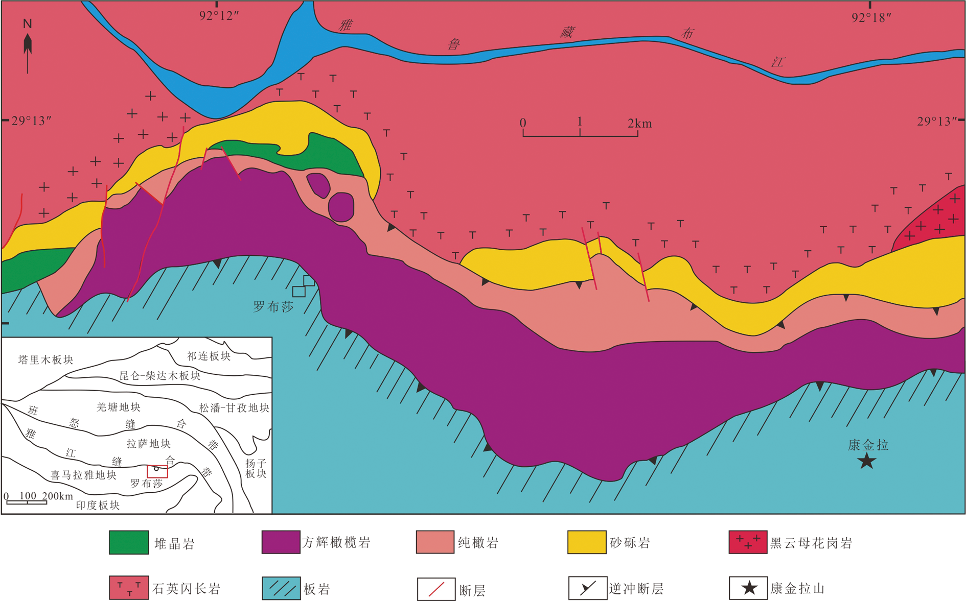
Fig.1 Regional geological map of Luobusa, Tibet
| 成像方式 | 推扫式扫描成像 | |
|---|---|---|
| 传感器 | 全色波段 | 多光谱 |
| 分辨率 | 0.5 m | 2 m |
| 蓝:450~510 nm | ||
| 绿:510~580 nm | ||
| 红:630~690 nm | ||
| 波长 | 450~1 040 nm | 近红外1:770~895 nm |
| 黄:585~625 nm | ||
| 海岸:400~450 nm | ||
| 红色边缘:705~745 nm | ||
| 近红外2:860~1 040 nm | ||
Table 1 Band parameters of WorldView-2 satellite
| 成像方式 | 推扫式扫描成像 | |
|---|---|---|
| 传感器 | 全色波段 | 多光谱 |
| 分辨率 | 0.5 m | 2 m |
| 蓝:450~510 nm | ||
| 绿:510~580 nm | ||
| 红:630~690 nm | ||
| 波长 | 450~1 040 nm | 近红外1:770~895 nm |
| 黄:585~625 nm | ||
| 海岸:400~450 nm | ||
| 红色边缘:705~745 nm | ||
| 近红外2:860~1 040 nm | ||
| 波段组合方案 | 标准差和 | 相关系数和 | OIF |
|---|---|---|---|
| 861 | 627.654 854 | 2.737 397 | 229.288 939 1 |
| 851 | 532.812 906 | 2.682 793 | 198.603 808 0 |
| 841 | 601.792 588 | 2.718 914 | 221.335 646 5 |
| 831 | 575.576 406 | 2.700 500 | 213.136 976 9 |
| 864 | 727.229 738 | 2.848 618 | 255.292 123 4 |
| 863 | 701.013 556 | 2.797 687 | 250.568 972 2 |
| 753 | 580.642 100 | 2.846 857 | 203.958 997 6 |
| 761 | 602.125 322 | 2.753 109 | 218.707 403 9 |
| 751 | 507.283 374 | 2.745 784 | 184.749 919 9 |
| 741 | 576.263 056 | 2.750 203 | 209.534 734 7 |
Table 2 OIF results of different bands combination
| 波段组合方案 | 标准差和 | 相关系数和 | OIF |
|---|---|---|---|
| 861 | 627.654 854 | 2.737 397 | 229.288 939 1 |
| 851 | 532.812 906 | 2.682 793 | 198.603 808 0 |
| 841 | 601.792 588 | 2.718 914 | 221.335 646 5 |
| 831 | 575.576 406 | 2.700 500 | 213.136 976 9 |
| 864 | 727.229 738 | 2.848 618 | 255.292 123 4 |
| 863 | 701.013 556 | 2.797 687 | 250.568 972 2 |
| 753 | 580.642 100 | 2.846 857 | 203.958 997 6 |
| 761 | 602.125 322 | 2.753 109 | 218.707 403 9 |
| 751 | 507.283 374 | 2.745 784 | 184.749 919 9 |
| 741 | 576.263 056 | 2.750 203 | 209.534 734 7 |

Fig.2 WorldView-2 RGB (864) image of conglomerate and field photographs

Fig.3 WorldView-2 RGB (864) image of sandstone and field photographs

Fig.4 WorldView-2 RGB (532) image of marble

Fig.5 WorldView-2 RGB (864) image of slate and field photograph

Fig.6 WorldView-2 RGB (864) image of listwanite and field photographs

Fig.7 WorldView-2 RGB (864) images of peridotite and field photographs

Fig.8 WorldView-2 RGB (864) image of normal fault in Luobusa area and field photographs

Fig.9 WorldView-2 RGB (864) images of northern thrust fault in Luobusa ophiolite belt

Fig.10 WorldView-2 RGB (864) image of southern thrust fault in Luobusa ophiolite belt and field identification

Fig.11 WorldView-2 RGB (864) image of wrench fault in Luobusa area

Fig.12 WorldView-2 RGB (864) images of joint in Luobusa area

Fig.13 Interpreted diagram of WorldView-2 in the study area
| [1] | 张玉君, 杨建民, 姚佛军, 等. 多光谱遥感找矿信息提取实用技术[M]. 北京: 地质出版社, 2013:1-272. |
| [2] | 王润生, 熊盛青, 聂洪峰, 等. 遥感地质勘查技术与应用研究[J]. 地质学报, 2011, 85(11):1700-1743. |
| [3] |
IBRAHIM W S, WATANABE K, YONEZU K. Structural and litho-tectonic controls on Neoproterozoic base metal sulfide and gold mineralization in North Hamisana shear zone, South Eastern Desert, Egypt: The integrated field, structural, Landsat 7 ETM+ and ASTER data approach[J]. Ore Geology Reviews, 2016, 79:62-77.
DOI URL |
| [4] |
MWANIKI M W, MATTHIAS M S, SCHELLMANN G. Application of remote sensing technologies to map the structural geology of central region of Kenya[J]. IEEE Journal of Selected Topics in Applied Earth Observations and Remote Sensing, 2015, 8(4):1855-1867.
DOI URL |
| [5] |
GUHA A, GHOSH B, KUMAR K V, et al. Implementation of reflection spectroscopy based new ASTER indices and principal components to delineate chromitite and associated ultramafic-mafic complex in parts of Dharwar Craton, India[J]. Advances in Space Research, 2015, 56(7):1453-1468.
DOI URL |
| [6] | 王乐, 何政伟, 刘婷婷, 等. 西藏尼雄铜铁多金属成矿带遥感找矿模式与找矿方向[J]. 现代地质, 2012, 26(3):489-497. |
| [7] | 张渊, 钱建平, 谢彪武, 等. 遥感蚀变和线性构造信息提取在西藏阿里住浪矿区一带的找矿应用[J]. 现代地质, 2013, 27(1):99-107. |
| [8] | 宋晚郊, 张绪教, 高万里, 等. 东昆仑造山带巴颜喀拉山群ASTER岩性信息提取[J]. 现代地质, 2013, 27(1):116-123. |
| [9] | 张志军, 刘世华, 孔迪, 等. 北巴颜喀拉山1∶5万区域地质调查中的遥感解译应用[J]. 现代地质, 2016, 30(5):1141-1149. |
| [10] | 金剑, 田淑芳, 焦润成, 等. 基于地物光谱分析的WorldView-2数据岩性识别:以新疆乌鲁克萨依地区为例[J]. 现代地质, 2013, 27(2):489-496. |
| [11] |
XONG F H, YANG J S, ROBINSON P T, et al. Origin of podiform chromitite, a new model based on the Luobusa ophiolite, Tibet[J]. Gondwana Research, 2015, 27(2):525-542.
DOI URL |
| [12] | 叶培盛, 江万, 吴珍汉, 等. 西藏泽当—罗布莎蛇绿岩的地球化学特征及其构造意义[J]. 现代地质, 2006, 20(3):370-377. |
| [13] | 王希斌, 周详, 郝梓国. 西藏罗布莎铬铁矿床的进一步找矿意见和建议[J]. 地质通报, 2010, 29(1):105-114. |
| [14] |
ZHOU M F. REE and PGE geochemical constraints on the formation of dunites in the Luobusa Ophiolite, Southern Tibet[J]. Journal of Petrology, 2004, 46(3):615-639.
DOI URL |
| [15] |
BAI W J, ROBINSON P T, HU X F, et al. The PGE and base-metal alloys in the podiform chromitites of the Luobusa opholite, Southern Tibet[J]. The Canadian Mineralogist, 2000, 38(3):585-598.
DOI URL |
| [16] | 李金阳, 杨经绥, 巴登珠, 等. 西藏罗布莎蛇绿岩中不同产出的纯橄岩及成因探讨[J]. 岩石学报, 2012, 28(6):1829-1845. |
| [17] | 白文吉, ROBINSON P T, 方青松, 等. 藏南罗布莎蛇绿岩豆荚状铬铁矿中的铂族元素和贱金属合金[J]. 地球学报, 2004, 25(4):385-396. |
| [18] | 翟裕生, 姚书振, 蔡克勤. 矿床学[M]. 3版. 北京: 地质出版社, 2011:1-434. |
| [19] | 杨经绥, 白文吉, 方青松, 等. 西藏罗布莎蛇绿岩铬铁矿中的超高压矿物和新矿物(综述)[J]. 地球学报, 2008, 29(3):263-274. |
| [20] | 王希斌, 鲍佩声, 邓万明, 等. 西藏蛇绿岩[M]. 北京: 地质出版社, 1987:1-336. |
| [21] | 白文吉, 杨经绥, ROBINSON P T, 等. 西藏罗布莎蛇绿岩铬铁矿中金刚石的研究[J]. 地质学报, 2001, 75(3):404-409. |
| [22] | 王恒生, 白文吉, 王炳熙, 等. 中国铬铁矿床及成因[M]. 北京: 科学出版社, 1983:1-227. |
| [23] |
ZHOU J J, TIAN S F, WANG N, et al. Enhancement and application of WorldView-2 to geological interpretation[J]. Advanced Materials Research, 2014, 1010/1012:1237-1242.
DOI URL |
| [24] | 梅安新, 彭望琭, 秦其明, 等. 遥感导论[M]. 北京: 高等教育出版社, 2001:1-324. |
| [25] | 焦润成, 秦彦平, 张淑云, 等. WorldView-2数据在沉积岩地区的遥感岩性增强方法初探[J]. 西北地质, 2014, 47(4):278-283. |
| [26] | 陈玲, 张微, 周艳, 等. 高分辨率遥感影像在新疆塔什库尔干地区沉积变质型铁矿勘查中的应用[J]. 地质与勘探, 2012, 48(5):1039-1048. |
| [27] | 杨金中, 孙延贵, 秦绪文, 等. 高分辨率遥感地质调查[M]. 北京: 测绘出版社, 2013:1-225. |
| [28] | 张岚. 藏南罗布莎蛇绿岩边部石英菱镁岩成因及矿化作用[D]. 北京: 中国地质大学(北京), 2016:1-83. |
| [29] | 刘新星, 陈建平, 曾敏, 等. 基于多源遥感数据的西藏羌多地区地质构造解译[J]. 国土资源遥感, 2015, 27(3):154-160. |
| [30] | 赵佳楠, 田淑芳. 新疆塔什库尔干地区柯岗断裂性质及遥感地质解译[J]. 新疆地质, 2013, 31(2):152-155. |
| [31] | 张瑞丝, 陈建平, 曾敏. 基于WorldView-Ⅱ遥感影像的西藏改则地区断裂构造解译研究及应用[J]. 遥感技术与应用, 2012, 27(2):266-274. |
| [32] | 崔军文, 乔子江. 罗布莎铬铁矿区成矿构造条件的研究[J]. 矿床地质, 1983, 2(1):48-57. |
| [33] | 白文吉, 杨经绥, ROBINSON P T, 等. 西藏罗布莎蛇绿岩铬铁矿中金刚石的研究[J]. 地质学报, 2001, 75(3): 404-409. |
| [34] | 李德威. 西藏罗布莎豆荚状铬铁矿成矿演化的构造过程[J]. 现代地质, 1995, 9(4):450-458. |
| [35] | 徐向珍. 藏南康金拉豆荚状铬铁矿和地幔橄榄岩成因研究[D]. 北京: 中国地质科学院, 2009:1-189. |
| [1] | WANG Jianhua, ZHU Youan, LI Qiang. Sedimentary and Paleontological Characteristics of Early Devonian Sequence in the Pali Area in Yadong, South Tibet [J]. Geoscience, 2024, 38(01): 224-229. |
| [2] | LI Yuchun, XIAO Shiqi. Characteristics of the Geoheritage in Xigaze of Tibet and Its Feasibility for Geopark Construction [J]. Geoscience, 2024, 38(01): 260-268. |
| [3] | LI Junlei, ZHANG Xujiao, WANG Yifan, ZHANG Xiangge, WANG Chongge, YUAN Xiaoning, LIU Xinlan, WANG Kaiya, RAO Haoshu, LIU Jiang, QIN Yuan. Route Planning and Ponder of Geoscience Study Travel in Hualong County, Qinghai Province [J]. Geoscience, 2023, 37(05): 1411-1422. |
| [4] | LOU Yuanlin, CHENG Ming, TANG Yao, ZHANG Chaoming, LAN Jingzhou, YUAN Yongsheng, YANG Tao. Geochemical Characteristics,Tectonic Setting, and Mineralization of Magmatic Rocks in Gudui Area, Southern Tibet [J]. Geoscience, 2023, 37(02): 353-374. |
| [5] | LIU Xinlan, ZHANG Xujiao, LI Junlei, WANG Yifan, ZHANG Xiangge, YUAN Xiaoning, WANG Kaiya, WANG Chongge, LIU Jiang, HOU Engang. Characteristics and Scientific Values of “Canyon and Danxia” Landform in Hualong County, Qinghai Province [J]. Geoscience, 2023, 37(01): 233-244. |
| [6] | DU Baofeng, ZHANG Rongzhen, YANG Changqing, LI Shanpo, TAN Heyong, ZHU Hongyun. Sulfur and Lead Isotopic Compositions of Zebuxia Pb-Zn Deposit in Tibet:Implications for the Sources of Ore-forming Material [J]. Geoscience, 2022, 36(04): 1138-1145. |
| [7] | HU Mengjun, JI Tianqi, ZHENG Dengyou, ZHUANG Jing, SUN Wenli, XU Aokang. Variation Characteristics of Chromatic Parameters of Eolian Sediments and Environmental Evolution on the Northeastern Tibetan Plateau Since 9.4 ka [J]. Geoscience, 2022, 36(02): 439-448. |
| [8] | FANG Nianqiao. Practice and Thinking on the Study of “Sea-Land Correlation” [J]. Geoscience, 2022, 36(01): 1-13. |
| [9] | CHEN Yaofei, HOU Engang, GAO Jinhan, XIAO Hongji, WANG Genhou. Sedimentary Environment and Tectonic Significance of the Upper Triassic Rigain Pünco Formation in the Rongma Region, Tibet, China [J]. Geoscience, 2022, 36(01): 48-57. |
| [10] | CHEN Shumin, MIAO Yu, LIAO Jia, HE Qianping, CHENG Ming, ZHANG Zhenli, WU Shaoan, ZHANG Zhiming. Crustal Evolution Constraints from the Petrogenesis of Late Cretaceous Konglong Volcanics on Southern Margin of Central Lhasa Subterrane [J]. Geoscience, 2021, 35(06): 1713-1726. |
| [11] | ZHANG Zhiping, ZHONG Kanghui, SHAN Shucheng, ZHENG Xin, HUANG Haozhen, YAN Zhao. Late Cretaceous Evolution of the Neo-Tethys:Evidence from Geochronology, Geochemistry, and Sr-Nd Isotopes of Gongguori Monzogranite in Zedang [J]. Geoscience, 2021, 35(05): 1194-1205. |
| [12] | CHEN Jing, LI Dapeng, KANG Huan, GENG Jianzhen, ZHANG Jingjing. Provenances and Tectonic Significance of Detrital Zircons from the Triassic to Jurassic Sedimentary Rocks in the Diancangshan Metamorphic Massif, Western Yunnan Province [J]. Geoscience, 2021, 35(04): 883-913. |
| [13] | GUO Changbao, WU Rui’an, JIANG Liangwen, ZHONG Ning, WANG Yang, WANG Dong, ZHANG Yongshuang, YANG Zhihua, MENG Wen, LI Xue, LIU Gui. Typical Geohazards and Engineering Geological Problems Along the Ya’an-Linzhi Section of the Sichuan-Tibet Railway,China [J]. Geoscience, 2021, 35(01): 1-17. |
| [14] | WANG Jiazhu, GAO Yanchao, RAN Tao, TIE Yongbo, ZHANG Fan. Analysis of Genetic Mechanism and Failure Mode of a Large Paleo-landslide in Sichuan-Tibet Railway Transportation Corridor [J]. Geoscience, 2021, 35(01): 18-25. |
| [15] | YAN Yiqiu, YANG Zhihua, ZHANG Xujiao, MENG Shaowei, GUO Changbao, WU Ruian, ZHANG Yiying. Landslide Susceptibility Assessment Based on Weight-of-Evidence Modeling of the Batang Fault Zone, Eastern Tibetan Plateau [J]. Geoscience, 2021, 35(01): 26-37. |
| Viewed | ||||||
|
Full text |
|
|||||
|
Abstract |
|
|||||