

Geoscience ›› 2024, Vol. 38 ›› Issue (03): 706-717.DOI: 10.19657/j.geoscience.1000-8527.2024.053
• Observation Simulation and Prediction Evaluation of Superbiotic Resources • Previous Articles Next Articles
LI Hongyu1,2,3( ), LIU Xiaohuang1,3(), LIU Jiufen1,2,3, ZHAO Xiaofeng1,2,3, ZHANG Wenbo1,2,3, LI Fujie3,4
Online:2024-06-10
Published:2024-07-04
CLC Number:
LI Hongyu, LIU Xiaohuang, LIU Jiufen, ZHAO Xiaofeng, ZHANG Wenbo, LI Fujie. Geomorphology-based Classification of Ground Substrate Texture in Xinjiang[J]. Geoscience, 2024, 38(03): 706-717.
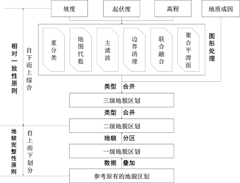
Fig.1 Technical flow chart of geomorphologic regionalization in Xinjiang
| 坡度 (°) | 基本 地貌 | 起伏度 (m) | 一级地 貌类型 | 高程 (m) | 二级地 貌类型 | 三级地 貌类型 |
|---|---|---|---|---|---|---|
| <7 | 平原 | - | 平原 | <1000 | 低海拔 平原 | (1)低海拔冲积平原;(2)低海拔洪积平原;(3)低海拔冲积洪积平原;(4)低海拔干燥洪积平原;(5)低海拔湖积平原;(6)低海拔洪积湖积平原;(7)低海拔冲积风积平原;(8)低海拔剥蚀平原;(9)低海拔冲积台地;(10)低海拔冲积洪积台地;(11)低海拔干燥洪积台地;(12)低海拔剥蚀台地;(13)低海拔风积地貌;(14)沙丘;(15)低海拔黄土梁峁 |
| 1000~3500 | 中海拔 平原 | (16)中海拔冲积平原;(17)中海拔洪积平原;(18)中海拔冲积洪积平原;(19)中海拔干燥洪积平原;(20)中海拔湖积平原;(21)中海拔洪积湖积平原;(22)中海拔剥蚀平原;(23)中海拔洪积台地;(24)中海拔冲积洪积台地;(25)中海拔干燥洪积台地;(26)中海拔剥蚀台地;(27)中海拔风积地貌;(28)中海拔黄土梁峁 | ||||
| 3500~5000 | (29)高海拔平原 | |||||
| >5000 | (30)极高海拔平原 | |||||
| ≥7 | 山地 | <200 | 丘陵 | <1000 | (31)低海拔丘陵 | |
| 1000~3500 | (32)中海拔丘陵 | |||||
| 3500~5000 | (33)高海拔丘陵 | |||||
| >5000 | (34)极高海拔丘陵 | |||||
| 200~500 | 小起伏 山地 | <1000 | (35)小起伏低山 | |||
| 1000~3500 | (36)小起伏中山 | |||||
| 3500~5000 | (37)小起伏高山 | |||||
| >5000 | (38)小起伏极高山 | |||||
| 500~1000 | 中起伏 山地 | <1000 | (39)中起伏低山 | |||
| 1000~3500 | (40)中起伏中山 | |||||
| 3500~5000 | (41)中起伏高山 | |||||
| >5000 | (42)中起伏极高山 | |||||
| 1000~2500 | 大起伏 山地 | 1000~3500 | (43)大起伏中山 | |||
| 3500~5000 | (44)大起伏高山 | |||||
| >5000 | (45)大起伏极高山 | |||||
| ≥2500 | 极大起 伏山地 | 3500~5000 | (46)极大起伏高山 | |||
| >5000 | (47)极大起伏极高山 | |||||
Table 1 Indicator system of the geomorphologic types in Xinjiang
| 坡度 (°) | 基本 地貌 | 起伏度 (m) | 一级地 貌类型 | 高程 (m) | 二级地 貌类型 | 三级地 貌类型 |
|---|---|---|---|---|---|---|
| <7 | 平原 | - | 平原 | <1000 | 低海拔 平原 | (1)低海拔冲积平原;(2)低海拔洪积平原;(3)低海拔冲积洪积平原;(4)低海拔干燥洪积平原;(5)低海拔湖积平原;(6)低海拔洪积湖积平原;(7)低海拔冲积风积平原;(8)低海拔剥蚀平原;(9)低海拔冲积台地;(10)低海拔冲积洪积台地;(11)低海拔干燥洪积台地;(12)低海拔剥蚀台地;(13)低海拔风积地貌;(14)沙丘;(15)低海拔黄土梁峁 |
| 1000~3500 | 中海拔 平原 | (16)中海拔冲积平原;(17)中海拔洪积平原;(18)中海拔冲积洪积平原;(19)中海拔干燥洪积平原;(20)中海拔湖积平原;(21)中海拔洪积湖积平原;(22)中海拔剥蚀平原;(23)中海拔洪积台地;(24)中海拔冲积洪积台地;(25)中海拔干燥洪积台地;(26)中海拔剥蚀台地;(27)中海拔风积地貌;(28)中海拔黄土梁峁 | ||||
| 3500~5000 | (29)高海拔平原 | |||||
| >5000 | (30)极高海拔平原 | |||||
| ≥7 | 山地 | <200 | 丘陵 | <1000 | (31)低海拔丘陵 | |
| 1000~3500 | (32)中海拔丘陵 | |||||
| 3500~5000 | (33)高海拔丘陵 | |||||
| >5000 | (34)极高海拔丘陵 | |||||
| 200~500 | 小起伏 山地 | <1000 | (35)小起伏低山 | |||
| 1000~3500 | (36)小起伏中山 | |||||
| 3500~5000 | (37)小起伏高山 | |||||
| >5000 | (38)小起伏极高山 | |||||
| 500~1000 | 中起伏 山地 | <1000 | (39)中起伏低山 | |||
| 1000~3500 | (40)中起伏中山 | |||||
| 3500~5000 | (41)中起伏高山 | |||||
| >5000 | (42)中起伏极高山 | |||||
| 1000~2500 | 大起伏 山地 | 1000~3500 | (43)大起伏中山 | |||
| 3500~5000 | (44)大起伏高山 | |||||
| >5000 | (45)大起伏极高山 | |||||
| ≥2500 | 极大起 伏山地 | 3500~5000 | (46)极大起伏高山 | |||
| >5000 | (47)极大起伏极高山 | |||||
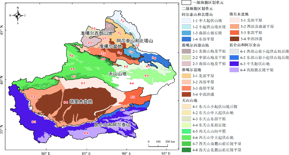
Fig.2 Map of first level and second-level geomorphologic regionalization in Xinjiang
| 一级区划 | 面积(104 km2) | 二级区划 | 面积(104 km2) | 包含三级区划个数 |
|---|---|---|---|---|
| 1. 阿尔泰山和北塔山 | 10.7 | 1-1中大起伏山地 | 3.7 | 21 |
| 1-2小起伏山地丘陵 | 1.9 | 20 | ||
| 1-3南部山前丘陵 | 1.6 | 6 | ||
| 1-4东部平原 | 3.4 | 29 | ||
| 2. 准噶尔西部山地 | 5.4 | 2-1北部山地及平原 | 1.4 | 19 |
| 2-2中部山地及平原 | 1.8 | 22 | ||
| 2-3南部山地及平原 | 2.1 | 28 | ||
| 3. 准噶尔盆地 | 15.2 | 3-1北部平原 | 4.8 | 24 |
| 3-2西部平原 | 2.6 | 14 | ||
| 3-3南部平原 | 4.2 | 12 | ||
| 3-4中部沙漠 | 3.7 | 3 | ||
| 4. 天山山地 | 46.5 | 4-1东天山小起伏山地丘陵 | 2.7 | 42 |
| 4-2东天山中大起伏山地 | 3.1 | 19 | ||
| 4-3东天山东部平原 | 6.8 | 34 | ||
| 4-4东天山东部丘陵 | 8.9 | 92 | ||
| 4-5西天山山间平原 | 3.1 | 57 | ||
| 4-6西天山中大起伏山地 | 17.4 | 112 | ||
| 4-7西天山南麓山前丘陵平原 | 3.2 | 54 | ||
| 4-8西天山北麓山前丘陵平原 | 1.4 | 27 | ||
| 5. 塔里木盆地 | 53.2 | 5-1北部平原 | 8.7 | 15 |
| 5-2西部及南部平原 | 11.2 | 34 | ||
| 5-3东部平原 | 4.3 | 7 | ||
| 5-4中部沙漠 | 29.0 | 18 | ||
| 6. 昆仑山和阿尔金山 | 35.8 | 6-1西部山前小起伏山地丘陵 | 1.6 | 24 |
| 6-2东部山前小起伏山地丘陵 | 2.0 | 17 | ||
| 6-3中大起伏山地 | 22.8 | 172 | ||
| 6-4高海拔丘陵平原 | 9.5 | 134 |
Table 2 Overview of the first-level and second-level geomorphologic regionalization
| 一级区划 | 面积(104 km2) | 二级区划 | 面积(104 km2) | 包含三级区划个数 |
|---|---|---|---|---|
| 1. 阿尔泰山和北塔山 | 10.7 | 1-1中大起伏山地 | 3.7 | 21 |
| 1-2小起伏山地丘陵 | 1.9 | 20 | ||
| 1-3南部山前丘陵 | 1.6 | 6 | ||
| 1-4东部平原 | 3.4 | 29 | ||
| 2. 准噶尔西部山地 | 5.4 | 2-1北部山地及平原 | 1.4 | 19 |
| 2-2中部山地及平原 | 1.8 | 22 | ||
| 2-3南部山地及平原 | 2.1 | 28 | ||
| 3. 准噶尔盆地 | 15.2 | 3-1北部平原 | 4.8 | 24 |
| 3-2西部平原 | 2.6 | 14 | ||
| 3-3南部平原 | 4.2 | 12 | ||
| 3-4中部沙漠 | 3.7 | 3 | ||
| 4. 天山山地 | 46.5 | 4-1东天山小起伏山地丘陵 | 2.7 | 42 |
| 4-2东天山中大起伏山地 | 3.1 | 19 | ||
| 4-3东天山东部平原 | 6.8 | 34 | ||
| 4-4东天山东部丘陵 | 8.9 | 92 | ||
| 4-5西天山山间平原 | 3.1 | 57 | ||
| 4-6西天山中大起伏山地 | 17.4 | 112 | ||
| 4-7西天山南麓山前丘陵平原 | 3.2 | 54 | ||
| 4-8西天山北麓山前丘陵平原 | 1.4 | 27 | ||
| 5. 塔里木盆地 | 53.2 | 5-1北部平原 | 8.7 | 15 |
| 5-2西部及南部平原 | 11.2 | 34 | ||
| 5-3东部平原 | 4.3 | 7 | ||
| 5-4中部沙漠 | 29.0 | 18 | ||
| 6. 昆仑山和阿尔金山 | 35.8 | 6-1西部山前小起伏山地丘陵 | 1.6 | 24 |
| 6-2东部山前小起伏山地丘陵 | 2.0 | 17 | ||
| 6-3中大起伏山地 | 22.8 | 172 | ||
| 6-4高海拔丘陵平原 | 9.5 | 134 |

Fig.3 Map of third-level geomorphologic regionalization in Xinjiang
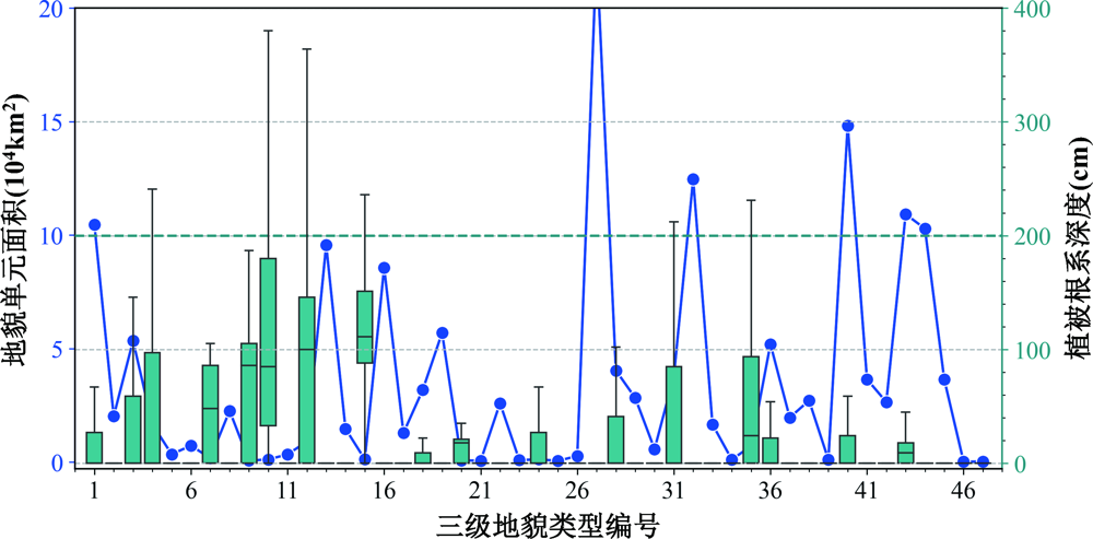
Fig.4 Area and vegetation rooting depth of different geomorphologic types in Xinjiang

Fig.5 Distribution of area proportion of major texture (a) and soil thickness and coarse fragments (b) of different geomorphologic types in Xinjiang
| 地表基质质地 (包含地貌类型数) | 地貌类型 |
|---|---|
| ①砂质(9) | 低海拔湖积平原、低海拔洪积湖积平原、低海拔冲积风积平原、低海拔冲积台地、低海拔剥蚀台地、低海拔风积地貌、沙丘、中海拔冲积平原、中海拔风积地貌 |
| ②砂壤质(13) | 低海拔洪积平原、低海拔干燥洪积平原、低海拔剥蚀平原、低海拔干燥洪积台地、中海拔洪积平原、中海拔剥蚀平原、中海拔洪积台地、中海拔干燥洪积台地、中海拔剥蚀台地、高海拔平原、极高海拔平原、高海拔丘陵、中起伏低山 |
| ③壤质(3) | 极高海拔丘陵、小起伏高山、小起伏极高山 |
| ④粉壤质(17) | 低海拔冲积平原、低海拔冲积洪积平原、低海拔冲积洪积台地、低海拔黄土梁峁、中海拔冲积洪积平原、中海拔干燥洪积平原、中海拔湖积平原、中海拔洪积湖积平原、中海拔冲积洪积台地、中海拔黄土梁峁、低海拔丘陵、中海拔丘陵、小起伏低山、小起伏中山、中起伏中山、中起伏高山、大起伏中山 |
| ⑤砾质(5) | 中起伏极高山、大起伏高山、大起伏极高山、极大起伏高山、极大起伏极高山 |
Table 3 Look-up table of ground substrate texture according to geomorphologic types
| 地表基质质地 (包含地貌类型数) | 地貌类型 |
|---|---|
| ①砂质(9) | 低海拔湖积平原、低海拔洪积湖积平原、低海拔冲积风积平原、低海拔冲积台地、低海拔剥蚀台地、低海拔风积地貌、沙丘、中海拔冲积平原、中海拔风积地貌 |
| ②砂壤质(13) | 低海拔洪积平原、低海拔干燥洪积平原、低海拔剥蚀平原、低海拔干燥洪积台地、中海拔洪积平原、中海拔剥蚀平原、中海拔洪积台地、中海拔干燥洪积台地、中海拔剥蚀台地、高海拔平原、极高海拔平原、高海拔丘陵、中起伏低山 |
| ③壤质(3) | 极高海拔丘陵、小起伏高山、小起伏极高山 |
| ④粉壤质(17) | 低海拔冲积平原、低海拔冲积洪积平原、低海拔冲积洪积台地、低海拔黄土梁峁、中海拔冲积洪积平原、中海拔干燥洪积平原、中海拔湖积平原、中海拔洪积湖积平原、中海拔冲积洪积台地、中海拔黄土梁峁、低海拔丘陵、中海拔丘陵、小起伏低山、小起伏中山、中起伏中山、中起伏高山、大起伏中山 |
| ⑤砾质(5) | 中起伏极高山、大起伏高山、大起伏极高山、极大起伏高山、极大起伏极高山 |

Fig.6 Map of ground substrate texture regionalization in Xinjiang

Fig.7 Comparison of area (a) and NDVI (b) of different ground substrate textures of natural resources in Xinjiang
| [1] | 自然资源部. 自然资源部关于印发《自然资源调查监测体系构建总体方案》的通知[EB/OL].(2020-01-17)[2023-09-01]. http://gi.mnr.gov.cn/202001/t20200117_2498071.html. |
| [2] | 殷志强, 秦小光, 张蜀冀, 等. 地表基质分类及调查初步研究[J]. 水文地质工程地质, 2020, 47(6): 8-14. |
| [3] |
侯红星, 葛良胜, 孙肖, 等. 地表基质在中国黑土地资源调查评价中的应用探讨: 基于黑龙江宝清地区地表基质调查[J]. 自然资源学报, 2022, 37(9): 2264-2276.
DOI |
| [4] | 邵海, 王英男, 殷志强, 等. 承德坝上高原如意河流域地表基质调查与编图探索[J]. 水文地质工程地质, 2023, 50(2): 150-159. |
| [5] | 陈国光, 湛龙, 刘红樱, 等. 地质调查支撑服务福建生态文明试验区理论与方法探索[J]. 华东地质, 2022, 43(1): 1-16. |
| [6] | DONG X L, MARTIN J B, COHEN M J, et al. Bedrock mediates responses of ecosystem productivity to climate variability[J]. Communications Earth & Environment, 2023, 4: 114. |
| [7] | LI H Y, LIU X H, ZHANG W B, et al. Elevational patterns of forest evapotranspiration and its sensitivity to climatic variation in dryland mountains[J]. Water, 2024, 16(9): 1252. |
| [8] | BENDALL E R, COLLINS L C, MILNER K V, et al. Demographic change and loss of big trees in resprouting eucalypt forests exposed to megadisturbance[J]. Global Ecology and Biogeography, 2024: e13842. https://doi.org/10.1111/geb.13842. |
| [9] | 自然资源部. 自然资源部办公厅关于印发《地表基质分类方案(试行)》的通知[EB/OL].(2020-12-12)[2023-09-01]. |
| [10] | 董天钰, 刘晓煌, 常铭, 等. 浅析地表基质的本质内涵及研究方向[J]. 西北地质, 2023, 56(4): 213-217. |
| [11] | 殷志强, 陈自然, 李霞, 等. 地表基质综合调查:内涵、分层、填图与支撑目标[J]. 水文地质工程地质, 2023, 50(1): 144-151. |
| [12] | 刘清俊, 刘雨鑫, 王颖, 等. 地表基质三级分类方案探讨[J]. 城市地质, 2023, 18(1): 1-8. |
| [13] | 李响, 周效华, 相振群, 等. 地表基质调查的工作思路刍议:以海南岛为例[J]. 地质通报, 2023, 42(1): 68-75. |
| [14] | 姚晓峰, 杨建锋, 左力艳, 等. 地表基质的内涵辨析与调查思路[J]. 地质通报, 2022, 41(12): 2097-2105. |
| [15] | 吴克宁, 赵瑞. 土壤质地分类及其在我国应用探讨[J]. 土壤学报, 2019, 56(1): 227-241. |
| [16] | MARTÍN M Á, PACHEPSKY Y A, GARCÍA-GUTIÉRREZ C, et al. On soil textural classifications and soil-texture-based estimations[J]. Solid Earth, 2018, 9(1): 159-165. |
| [17] | DHARUMARAJAN S, HEGDE R. Digital mapping of soil texture classes using Random Forest classification algorithm[J]. Soil Use and Management, 2022, 38(1): 135-149. |
| [18] | CONFORTI M, LONGOBUCCO T, SCARCIGLIA F, et al. Interplay between soil formation and geomorphic processes along a soil catena in a Mediterranean Mountain landscape: An integrated pedological and geophysical approach[J]. Environmental Earth Sciences, 2020, 79(2): 59. |
| [19] | RIZA S, SEKINE M, KANNO A, et al. Modeling soil landscapes and soil textures using hyperscale terrain attributes[J]. Geoderma, 2021, 402: 115177. |
| [20] | NAUMAN T W, BURCH S S, HUMPHRIES J T, et al. A quantitative soil-geomorphic framework for developing and mapping ecological site groups[J]. Rangeland Ecology & Management, 2022, 81: 9-33. |
| [21] |
程维明, 周成虎, 李炳元, 等. 中国地貌区划理论与分区体系研究[J]. 地理学报, 2019, 74(5): 839-856.
DOI |
| [22] |
张海燕, 樊江文, 黄麟, 等. 中国自然资源综合区划理论研究与技术方案[J]. 资源科学, 2020, 42(10): 1870-1882.
DOI |
| [23] | 张甘霖, 宋效东, 吴克宁. 地球关键带分类方法与中国案例研究[J]. 中国科学: 地球科学, 2021, 51(10): 1681-1692. |
| [24] | 柴慧霞, 周成虎, 陈曦, 等. 基于地理格网的新疆地貌区划方法与实现[J]. 地理研究, 2008, 27(3): 481-492, 725-726. |
| [25] | 师庆东, 王智, 贺龙梅, 等. 基于气候、地貌、生态系统的景观分类体系: 以新疆地区为例[J]. 生态学报, 2014, 34(12): 3359-3367. |
| [26] | 张军, 李晓东, 陈春艳, 等. 新疆地势起伏度的分析研究[J]. 兰州大学学报(自然科学版), 2008, 44(增): 10-13, 19. |
| [27] |
LIU F, WU H Y, ZHAO Y G, et al. Mapping high resolution national soil information grids of China[J]. Science Bulletin, 2022, 67(3): 328-340.
DOI PMID |
| [28] |
FAN Y, MIGUEZ-MACHO G, JOBBÁGY E G, et al. Hydrologic regulation of plant rooting depth[J]. Proceedings of the National Academy of Sciences of the United States of America, 2017, 114(40): 10572-10577.
DOI PMID |
| [29] | 刘玖芬, 赵晓峰, 侯红星, 等. 地表基质调查分层及分层测试指标体系设计与构建[J]. 岩矿测试, 2024, 43(1): 16-29. |
| [30] |
程维明, 高晓雨, 马廷, 等. 基于地貌分区的1990—2015年中国耕地时空特征变化分析[J]. 地理学报, 2018, 73(9): 1613-1629.
DOI |
| [31] | TAI X L, EPSTEIN H E, LI B. Elevation and climate effects on vegetation greenness in an arid mountain-basin system of central Asia[J]. Remote Sensing, 2020, 12(10): 1665. |
| [32] |
方月, 程维明, 周成虎, 等. 新疆土地耕作适宜性的多自然地理要素评价方法[J]. 地球信息科学学报, 2015, 17(7): 846-854.
DOI |
| [33] | 蒋万军, 赵丹, 王广才, 等. 新疆吐—哈盆地地下水水文地球化学特征及形成作用[J]. 现代地质, 2016, 30(4): 825-833. |
| [34] |
程维明, 柴慧霞, 方月, 等. 基于水资源分区和地貌特征的新疆耕地资源变化分析[J]. 自然资源学报, 2012, 27(11): 1809-1822.
DOI |
| [35] | 董秀茹, 刘浩洋, 刘洪彬. 基于耕地资源质量分类的辽宁省耕地土壤条件及空间分布特征分析[J]. 土壤通报, 2021, 52(5): 1020-1027. |
| [36] | 何海龙, 齐雁冰, 吕家珑, 等. 中国土壤质地分类系统的发展与建议修订方案[J]. 农业资源与环境学报, 2023, 40(3): 501-510, 496. |
| [37] | 夏鑫鑫, 朱磊, 杨爱民, 等. 基于山地-绿洲-荒漠系统的生态系统服务正负价值测算: 以新疆玛纳斯河流域为例[J]. 生态学报, 2020, 40(12): 3921-3934. |
| [38] | 夏学齐, 龚庆杰, 徐常艳. 2011—2020中国应用地球化学研究进展与展望之生态地球化学[J]. 现代地质, 2020, 34(5): 883-896. |
| [39] | 张凤荣. 论地表基质层重点调查内容和优先调查区域[J]. 中国土地, 2023(2): 40-41. |
| [40] |
王志华, 郜酷, 杨晓梅, 等. 地理学视角下土地利用/覆被分类发展探讨[J]. 地理研究, 2022, 41(11): 2946-2962.
DOI |
| Viewed | ||||||
|
Full text |
|
|||||
|
Abstract |
|
|||||