

Geoscience ›› 2024, Vol. 38 ›› Issue (03): 718-733.DOI: 10.19657/j.geoscience.1000-8527.2024.049
• Observation Simulation and Prediction Evaluation of Superbiotic Resources • Previous Articles Next Articles
ZHAO Xiaofeng1,2,3( ), LIU Xiaohuang1,3, LIU Jiufen1,2,3(), LI Hongyu1,2,3, ZHANG Wenbo1,2,3
Online:2024-06-10
Published:2024-07-04
CLC Number:
ZHAO Xiaofeng, LIU Xiaohuang, LIU Jiufen, LI Hongyu, ZHANG Wenbo. Suitability Assessment on the Croplands in Xinjiang Based on Multi-environmental Factors[J]. Geoscience, 2024, 38(03): 718-733.

Fig.1 Slope (a) and topographic zoning (b)in Xinjiang
| 耕地 类型 | 描述 | 面积 (km2) | 用于模型的点数(个) | |||
|---|---|---|---|---|---|---|
| 平原区 | 山地区 | |||||
| 旱地 | 无灌溉水源及设施,靠天然降水生长作物的耕地;有水源和浇灌设施,在一般年景下能正常灌溉的旱作物耕地;以种菜为主的耕地;正常耕作的休闲地和轮歇地 | 67957 | 18229 | 1776 | ||
| 水田 | 有水源保证和灌溉设施,在一般年景能正常灌溉,用以种植水稻、莲藕等水生农作物的耕地,包括实行水稻和旱地作物轮种的耕地 | 552 | 80 | - | ||
Table 1 Description and characterization of the drylands and paddy fields in Xinjiang
| 耕地 类型 | 描述 | 面积 (km2) | 用于模型的点数(个) | |||
|---|---|---|---|---|---|---|
| 平原区 | 山地区 | |||||
| 旱地 | 无灌溉水源及设施,靠天然降水生长作物的耕地;有水源和浇灌设施,在一般年景下能正常灌溉的旱作物耕地;以种菜为主的耕地;正常耕作的休闲地和轮歇地 | 67957 | 18229 | 1776 | ||
| 水田 | 有水源保证和灌溉设施,在一般年景能正常灌溉,用以种植水稻、莲藕等水生农作物的耕地,包括实行水稻和旱地作物轮种的耕地 | 552 | 80 | - | ||

Fig.2 Distribution of the drylands and paddy fields in Xinjiang
| 变量类型 | 变量 | 描述 | 时间范围与来源 | |
|---|---|---|---|---|
| 气候类 | 气温 | Tem_Avg | 年平均气温(℃) | 2000—2020年的平均值,国家气象科学数据中心( |
| Tem_Su | 夏季平均气温(6—8月)(℃) | |||
| Tem_Wi | 冬季平均气温(12—2月)(℃) | |||
| Accu_Tem0 | >0 ℃年积温(经DEM校正)(℃) | |||
| Accu_Tem10 | >10 ℃年积温(经DEM校正)(℃) | |||
| Tem_Days10 | 每年稳定>10 ℃天数(d) | |||
| 降水 | Pre_Avg | 年平均降水量(mm) | ||
| Pre_Su | 夏季平均降水(6—8月)(mm) | |||
| Pre_Wi | 冬季平均降水(12—2月)(mm) | |||
| Aridity | 干燥度 | |||
| 地形类 | Ele | 高程(m) | 2008年,地理空间数据云平台( | |
| Slope | 坡度(°) | |||
| Aspect | 坡向(°) | |||
| 水文类 | Dist_Water | 到五级水系的欧式距离(km) | 2008年,HydroSHEDS( | |
| 土壤类 | Soil_Tem1 | 土壤分层温度1(0~10 cm) | 2018—2022年的平均值,气象科学专业知识服务系统( | |
| Soil_Tem2 | 土壤分层温度2(10~20 cm) | |||
| Soil_Tem3 | 土壤分层温度3(20~40 cm) | |||
| Soil_Tem4 | 土壤分层温度4(40~100 cm) | |||
| Soil_Tem5 | 土壤分层温度5(100~200 cm) | |||
| Soil_Moi1 | 土壤分层湿度1(0~10 cm) | |||
| Soil_Moi2 | 土壤分层湿度2(10~20 cm) | |||
| Soil_Moi3 | 土壤分层湿度3(20~40 cm) | |||
| Soil_Moi4 | 土壤分层湿度4(40~100 cm) | |||
| Soil_Moi5 | 土壤分层湿度5(100~200 cm) | |||
| Soil_Depth | 土层厚度(cm) | 第二次全国土壤调查数据( | ||
| Sand | 土壤砂土含量(%) | |||
| Clay | 土壤黏土含量(%) | |||
| CEC | 阳离子交换量(meq/hg) | |||
| pH | 土壤pH | |||
| SOM | 土壤有机质(g/hg) | |||
| Ca | 可交换态Ca2+(meq/hg) | |||
| TN | 土壤总氮(g/hg) | |||
| TP | 土壤总磷(g/hg) | |||
| TK | 土壤总钾(g/hg) | |||
| 地质类 | Dist_Fault | 到断层欧式距离(m) | 1:25万区域地质图 | |
Table 2 Thirty-five environmental variables for the analysis of suitable areas for croplands in Xinjiang
| 变量类型 | 变量 | 描述 | 时间范围与来源 | |
|---|---|---|---|---|
| 气候类 | 气温 | Tem_Avg | 年平均气温(℃) | 2000—2020年的平均值,国家气象科学数据中心( |
| Tem_Su | 夏季平均气温(6—8月)(℃) | |||
| Tem_Wi | 冬季平均气温(12—2月)(℃) | |||
| Accu_Tem0 | >0 ℃年积温(经DEM校正)(℃) | |||
| Accu_Tem10 | >10 ℃年积温(经DEM校正)(℃) | |||
| Tem_Days10 | 每年稳定>10 ℃天数(d) | |||
| 降水 | Pre_Avg | 年平均降水量(mm) | ||
| Pre_Su | 夏季平均降水(6—8月)(mm) | |||
| Pre_Wi | 冬季平均降水(12—2月)(mm) | |||
| Aridity | 干燥度 | |||
| 地形类 | Ele | 高程(m) | 2008年,地理空间数据云平台( | |
| Slope | 坡度(°) | |||
| Aspect | 坡向(°) | |||
| 水文类 | Dist_Water | 到五级水系的欧式距离(km) | 2008年,HydroSHEDS( | |
| 土壤类 | Soil_Tem1 | 土壤分层温度1(0~10 cm) | 2018—2022年的平均值,气象科学专业知识服务系统( | |
| Soil_Tem2 | 土壤分层温度2(10~20 cm) | |||
| Soil_Tem3 | 土壤分层温度3(20~40 cm) | |||
| Soil_Tem4 | 土壤分层温度4(40~100 cm) | |||
| Soil_Tem5 | 土壤分层温度5(100~200 cm) | |||
| Soil_Moi1 | 土壤分层湿度1(0~10 cm) | |||
| Soil_Moi2 | 土壤分层湿度2(10~20 cm) | |||
| Soil_Moi3 | 土壤分层湿度3(20~40 cm) | |||
| Soil_Moi4 | 土壤分层湿度4(40~100 cm) | |||
| Soil_Moi5 | 土壤分层湿度5(100~200 cm) | |||
| Soil_Depth | 土层厚度(cm) | 第二次全国土壤调查数据( | ||
| Sand | 土壤砂土含量(%) | |||
| Clay | 土壤黏土含量(%) | |||
| CEC | 阳离子交换量(meq/hg) | |||
| pH | 土壤pH | |||
| SOM | 土壤有机质(g/hg) | |||
| Ca | 可交换态Ca2+(meq/hg) | |||
| TN | 土壤总氮(g/hg) | |||
| TP | 土壤总磷(g/hg) | |||
| TK | 土壤总钾(g/hg) | |||
| 地质类 | Dist_Fault | 到断层欧式距离(m) | 1:25万区域地质图 | |
| 存在概率 | 适宜区的划分 |
|---|---|
| <0.2 | 非适宜区 |
| 0.2~0.5 | 低适宜区 |
| >0.5 | 高适宜区 |
Table 3 Criteria for delineating suitable zones for the croplands in Xinjiang
| 存在概率 | 适宜区的划分 |
|---|---|
| <0.2 | 非适宜区 |
| 0.2~0.5 | 低适宜区 |
| >0.5 | 高适宜区 |
| 旱地(平原区) | 旱地(山地区) | 水田(平原区) | |||||
|---|---|---|---|---|---|---|---|
| 变量 | 贡献率(%) | 变量 | 贡献率(%) | 变量 | 贡献率(%) | ||
| TN | 33.6 | Accu_Tem0 | 32.2 | Dist_Water | 35.7 | ||
| Dist_Water | 30.8 | Pre_Wi | 29.8 | pH | 12.8 | ||
| Pre_Wi | 24.8 | Slope | 14.2 | Soil_Moi1 | 10.5 | ||
| Tem_Su | 4.1 | Dist_Water | 12.9 | Accu_Tem10 | 9.6 | ||
| Soil_Depth | 2.3 | Soil_Depth | 5.4 | SOM | 7.0 | ||
| Ele | 1.7 | TK | 2.4 | Dist_Fault | 5.7 | ||
| Sand | 1.2 | SOM | 1.2 | Tem_Su | 5.2 | ||
| TK | 1.2 | Soil_Moi1 | 1.1 | Slope | 4.2 | ||
| Soil_Moi4 | 0.3 | Ele | 0.9 | Ca | 3.9 | ||
| Aridity | 2.5 | ||||||
| Aspect | 1.9 | ||||||
| Clay | 1.1 | ||||||
Table 4 Variables and their contribution after removal of the spatial correlations
| 旱地(平原区) | 旱地(山地区) | 水田(平原区) | |||||
|---|---|---|---|---|---|---|---|
| 变量 | 贡献率(%) | 变量 | 贡献率(%) | 变量 | 贡献率(%) | ||
| TN | 33.6 | Accu_Tem0 | 32.2 | Dist_Water | 35.7 | ||
| Dist_Water | 30.8 | Pre_Wi | 29.8 | pH | 12.8 | ||
| Pre_Wi | 24.8 | Slope | 14.2 | Soil_Moi1 | 10.5 | ||
| Tem_Su | 4.1 | Dist_Water | 12.9 | Accu_Tem10 | 9.6 | ||
| Soil_Depth | 2.3 | Soil_Depth | 5.4 | SOM | 7.0 | ||
| Ele | 1.7 | TK | 2.4 | Dist_Fault | 5.7 | ||
| Sand | 1.2 | SOM | 1.2 | Tem_Su | 5.2 | ||
| TK | 1.2 | Soil_Moi1 | 1.1 | Slope | 4.2 | ||
| Soil_Moi4 | 0.3 | Ele | 0.9 | Ca | 3.9 | ||
| Aridity | 2.5 | ||||||
| Aspect | 1.9 | ||||||
| Clay | 1.1 | ||||||

Fig.3 ROC and AUC curves for the distribution model of suitable areas of the croplands in Xinjiang

Fig.4 Jackknife test of the drylands suitability analysis in plain regions (a) and mountain regions (b) in Xinjiang

Fig.5 Response curves of the main factors influencing suitability of drylands in plain regions of Xinjiang
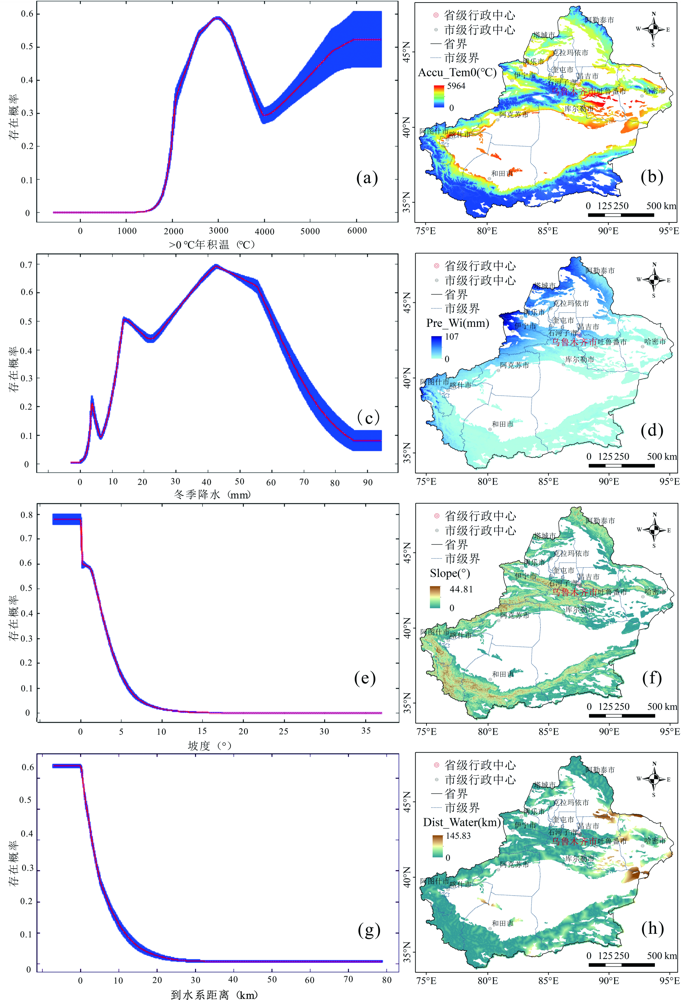
Fig.6 Response curves of the main factors influencing the suitability of drylands in mountain regions in Xinjiang

Fig.7 Distribution of suitable areas for the drylands in Xinjiang
| 序号 | 区域 | 高适宜区(km2) |
|---|---|---|
| 1 | 阿克苏地区 | 12372 |
| 2 | 阿勒泰地区 | 7852 |
| 3 | 巴音郭楞蒙古自治州 | 4664 |
| 4 | 博尔塔拉蒙古自治州 | 2791 |
| 5 | 昌吉回族自治州 | 9047 |
| 6 | 哈密市 | 100 |
| 7 | 和田地区 | 2003 |
| 8 | 喀什地区 | 12809 |
| 9 | 克拉玛依市 | 207 |
| 10 | 克孜勒苏柯尔克孜自治州 | 977 |
| 11 | 塔城地区 | 12820 |
| 12 | 吐鲁番市 | 680 |
| 13 | 乌鲁木齐市 | 1122 |
| 14 | 伊犁哈萨克自治州 | 10777 |
| 新疆全区域 | 78221 | |
Table 5 Statistics of high suitability areas for the drylands in Xinjiang by states/cities/regions
| 序号 | 区域 | 高适宜区(km2) |
|---|---|---|
| 1 | 阿克苏地区 | 12372 |
| 2 | 阿勒泰地区 | 7852 |
| 3 | 巴音郭楞蒙古自治州 | 4664 |
| 4 | 博尔塔拉蒙古自治州 | 2791 |
| 5 | 昌吉回族自治州 | 9047 |
| 6 | 哈密市 | 100 |
| 7 | 和田地区 | 2003 |
| 8 | 喀什地区 | 12809 |
| 9 | 克拉玛依市 | 207 |
| 10 | 克孜勒苏柯尔克孜自治州 | 977 |
| 11 | 塔城地区 | 12820 |
| 12 | 吐鲁番市 | 680 |
| 13 | 乌鲁木齐市 | 1122 |
| 14 | 伊犁哈萨克自治州 | 10777 |
| 新疆全区域 | 78221 | |

Fig.8 Jackknife test of paddy fields suitability analysis in the plain regions of Xinjiang

Fig.9 Response curves of the main factors influencing the suitability of paddy fields in the plain regions in Xinjiang

Fig.10 Distribution of suitable areas for the paddy fields in Xinjiang
| 序号 | 区域 | 高适宜区(km2) |
|---|---|---|
| 1 | 阿克苏地区 | 1774 |
| 2 | 巴音郭楞蒙古自治州 | 14 |
| 3 | 昌吉回族自治州 | 309 |
| 4 | 和田地区 | 1 |
| 5 | 喀什地区 | 284 |
| 6 | 克孜勒苏柯尔克孜自治州 | 1 |
| 7 | 塔城地区 | 59 |
| 8 | 乌鲁木齐市 | 181 |
| 9 | 伊犁哈萨克自治州 | 211 |
| 新疆全区域 | 2834 |
Table 6 Statistics of high suitability areas for the paddy fields in Xinjiang by states/cities/regions
| 序号 | 区域 | 高适宜区(km2) |
|---|---|---|
| 1 | 阿克苏地区 | 1774 |
| 2 | 巴音郭楞蒙古自治州 | 14 |
| 3 | 昌吉回族自治州 | 309 |
| 4 | 和田地区 | 1 |
| 5 | 喀什地区 | 284 |
| 6 | 克孜勒苏柯尔克孜自治州 | 1 |
| 7 | 塔城地区 | 59 |
| 8 | 乌鲁木齐市 | 181 |
| 9 | 伊犁哈萨克自治州 | 211 |
| 新疆全区域 | 2834 |
| [1] | HADDAD N M, BRUDVIG L A, CLOBERT J, et al. Habitat fragmentation and its lasting impact on Earth’s ecosystems[J]. Science Advances, 2015, 1(2): e1500052. |
| [2] | 王刚. 基于时空多尺度的盐城滨海湿地丹顶鹤栖息地选择及其影响机制研究[D]. 南京: 南京师范大学, 2021. |
| [3] | ZINKE L. Irrigation efficiency for expanded croplands[J]. Nature Reviews Earth & Environment, 2022, 3: 617. |
| [4] | FAHRIG L. Effects of habitat fragmentation on biodiversity[J]. Annual Review of Ecology, Evolution, and Systematics, 2003, 34: 487-515. |
| [5] |
LIND L, ECKSTEIN R L, RELYEA R A. Direct and indirect effects of climate change on distribution and community composition of macrophytes in lentic systems[J]. Biological Reviews of the Cambridge Philosophical Society, 2022, 97(4): 1677-1690.
DOI PMID |
| [6] |
NELSON N, JUNGE W. Structure and energy transfer in photosystems of oxygenic photosynthesis[J]. Annual Review of Biochemistry, 2015, 84: 659-683.
DOI PMID |
| [7] | 方精云, 王襄平, 沈泽昊, 等. 植物群落清查的主要内容、方法和技术规范[J]. 生物多样性, 2009, 17(6): 533-548. |
| [8] | GRUBER F E, BARUCK J, MAIR V, et al. From geological to soil parent material maps-A random forest-supported analysis of geological map units and topography to support soil survey in South Tyrol[J]. Geoderma, 2019, 354: 113884. |
| [9] | ANTONELLI A, KISSLING W D, FLANTUA S G A, et al. Geo-logical and climatic influences on mountain biodiversity[J]. Nature Geoscience, 2018, 11: 718-725. |
| [10] | KÜBLER S, RUCINA S, AßBICHLER D, et al. Lithological and topographic impact on soil nutrient distributions in tectonic landscapes: Implications for Pleistocene human-landscape interactions in the southern Kenya Rift[J]. Frontiers in Earth Science, 2021, 9: 611687. |
| [11] | 刘纪远, 匡文慧, 张增祥, 等. 20世纪80年代末以来中国土地利用变化的基本特征与空间格局[J]. 地理学报, 2014, 69(1): 3-14. |
| [12] | 刘毅. 新疆耕地质量建设模式研究[D]. 乌鲁木齐: 新疆农业大学, 2022. |
| [13] |
程维明, 柴慧霞, 方月, 等. 基于水资源分区和地貌特征的新疆耕地资源变化分析[J]. 自然资源学报, 2012, 27(11): 1809-1822.
DOI |
| [14] | 中华人民共和国国民经济和社会发展第十四个五年规划和2035年远景目标纲要[EB/OL]. [2021-03-13]. https://www.gov.cn/xinwen/2021-03/13/content_5592681.htm. |
| [15] | PHILLIPS S J, ANDERSON R P, DUDÍK M, et al. Opening the black box: An open-source release of Maxent[J]. Ecography, 2017, 40(7): 887-893. |
| [16] | 赵晓峰, 雷梅, 陈同斌. 中国镉超富集植物的物种、生境特征和筛选建议[J]. 环境科学, 2023, 44(5): 2786-2798. |
| [17] | 刘晓煌, 刘玖芬. 自然资源要素综合观测一体化平台简介[J]. 中国地质, 2022, 49(4): 1004. |
| [18] | 新疆维吾尔自治区人民政府网. 新疆概况[EB/OL].[2023-08-15]. https://www.xinjiang.gov.cn/xinjiang/dmxj/dmxj.shtml. |
| [19] | 柴慧霞, 周成虎, 陈曦, 等. 基于地理格网的新疆地貌区划方法与实现[J]. 地理研究, 2008, 27(3): 481-492, 725-726. |
| [20] | LIU J Y, KUANG W H, ZHANG Z X, et al. Spatiotemporal characteristics, patterns, and causes of land-use changes in China since the late 1980s[J]. Journal of Geographical Sciences, 2014, 24(2): 195-210. |
| [21] |
刘晓煌, 刘晓洁, 程书波, 等. 中国自然资源要素综合观测网络构建与关键技术[J]. 资源科学, 2020, 42(10): 1849-1859.
DOI |
| [22] | 刘晓煌, 刘玖芬. 自然资源要素综合观测网络工程简介[J]. 中国地质, 2022, 49(3): 678. |
| [23] | 张甘霖, 宋效东, 吴克宁. 地球关键带分类方法与中国案例研究[J]. 中国科学(地球科学), 2021, 51(10): 1681-1692. |
| [24] | 刘莹, 师春香, 王海军, 等. CLDAS气温数据在中国区域的适用性评估[J]. 大气科学学报, 2021, 44(4): 540-548. |
| [25] | SUN S, SHI C X, PAN Y, et al. Applicability assessment of the 1998-2018 CLDAS multi-source precipitation fusion dataset over China[J]. Journal of Meteorological Research, 2020, 34(4): 879-892. |
| [26] | 孙帅, 师春香, 梁晓, 等. 两种陆面模式对中国区域土壤温度模拟的对比分析[J]. 气象学报, 2022, 80(4): 533-545. |
| [27] | SHANGGUAN W, DAI Y J, LIU B Y, et al. A China data set of soil properties for land surface modeling[J]. Journal of Advances in Modeling Earth Systems, 2013, 5(2): 212-224. |
| [28] | 赵鹏大, 王京贵, 饶明辉, 等. 中国地质异常[J]. 地球科学, 1995, 20(2): 117-127. |
| [29] | PHILLIPS S J, ANDERSON R P, SCHAPIRE R E. Maximum entropy modeling of species geographic distributions[J]. Ecological Modelling, 2006, 190(3/4): 231-259. |
| [30] | ZHAO X F, LEI M, WEI C H, et al. Assessing the suitable regions and the key factors for three Cd-accumulating plants (Sedum alfredii, Phytolacca americana, and Hylotelephium spectabile) in China using MaxEnt model[J]. The Science of the Total Environment, 2022, 852: 158202. |
| [31] | PHILLIPS S J, DUDÍK M. Modeling of species distributions with Maxent: New extensions and a comprehensive evaluation[J]. Ecography, 2008, 31(2): 161-175. |
| [32] | ELITH J, PHILLIPS S J, HASTIE T, et al. A statistical explanation of MaxEnt for ecologists[J]. Diversity and Distributions, 2011, 17(1): 43-57. |
| [33] | YU X, TAO X, LIAO J, et al. Predicting potential cultivation region and paddy area for ratoon rice production in China using Maxent model[J]. Field Crops Research, 2022, 275:108372. |
| [34] | HE P, LI J Y, LI Y F, et al. Habitat protection and planning for three Ephedra using the MaxEnt and Marxan models[J]. Ecological Indicators, 2021, 133: 108399. |
| [35] | LI J J, FAN G, HE Y. Predicting the current and future distribution of three Coptis herbs in China under climate change conditions, using the MaxEnt model and chemical analysis[J]. The Science of the Total Environment, 2020, 698: 134141. |
| [36] | RADOSAVLJEVIC A, ANDERSON R P. Making better Maxent models of species distributions: Complexity, overfitting and eva-luation[J]. Journal of Biogeography, 2014, 41(4): 629-643. |
| [37] |
SWETS J A. Measuring the accuracy of diagnostic systems[J]. Science, 1988, 240: 1285-1293.
DOI PMID |
| [38] | FENG H M, LI Y H, LI Y Y, et al. Ide.pngying and evaluating the ecological network of Siberian roe Deer (Capreolus pygargus) in Tieli Forestry Bureau, Northeast China[J]. Global Ecology and Conservation, 2021, 26: e01477. |
| [39] | CAO B, BAI C K, ZHANG M, et al. Future landscape of renewable fuel resources: Current and future conservation and utilization of main biofuel crops in China[J]. The Science of the Total Environment, 2022, 806(4): 150946. |
| [40] | XU W M, DU Q L, YAN S, et al. Geographical distribution of As-hyper accumulator Pteris vittata in China: Environmental factors and climate changes[J]. The Science of the Total Environment, 2022, 803: 149864. |
| [41] | ZHANG S, LIU X, LI R, et al. AHP-GIS and MaxEnt for delineation of potential distribution of Arabica coffee plantation under future climate in Yunnan, China[J]. Ecological Indicators, 2021, 132: 108339. |
| [42] | BORIA R A, OLSON L E, GOODMAN S M, et al. Spatial filtering to reduce sampling bias can improve the performance of ecological niche models[J]. Ecological Modelling, 2014, 275: 73-77. |
| [43] | 师庆东, 王智, 贺龙梅, 等. 基于气候、地貌、生态系统的景观分类体系: 以新疆地区为例[J]. 生态学报, 2014, 34(12): 3359-3367. |
| [44] | FEELEY K J, MALHI Y, ZELAZOWSKI P, et al. The relative importance of deforestation, precipitation change, and temperature sensitivity in determining the future distributions and diversity of Amazonian plant species[J]. Global Change Biology, 2012, 18(8): 2636-2647. |
| [45] | SUMNER E, VENN S. Plant responses to changing water supply and availability in high elevation ecosystems: A quantitative systematic review and meta-analysis[J]. Land, 2021, 10(11):1150. |
| [46] | WALCK J L, HIDAYATI S N, DIXON K W, et al. Climate change and plant regeneration from seed[J]. Global Change Biology, 2011, 17(6): 2145-2161. |
| [47] | ZHU H, MA Y X, YAN L C, et al. The relationship between geography and climate in the generic-level patterns of Chinese seed plants[J]. Acta Phytotaxon Sin, 2007, 45(2): 134-166. |
| [48] | NYLE C B, RAY R W. 土壤学与生活[M].李保国, 徐建明,译. 北京: 科学出版社, 2019. |
| [49] | XI N X, CHEN D X, BAHN M, et al. Drought soil legacy alters drivers of plant diversity-productivity relationships in oldfield systems[J]. Science Advances, 2022, 8(18): eabn3368. |
| [50] |
WU L J, CHEN H S, CHEN D M, et al. Soil biota diversity and plant diversity both contributed to ecosystem stability in grasslands[J]. Ecology Letters, 2023, 26(6): 858-868.
DOI PMID |
| [51] | VILLARINO S H, PINTO P, JACKSON R B, et al. Plant rhizodeposition: A key factor for soil organic matter formation in stable fractions[J]. Science Advances, 2021, 7(16): eabd3176. |
| [52] | COBAN O, DE DEYN G B, VAN DER PLOEG M. Soil microbiota as game-changers in restoration of degraded lands[J]. Science, 2022, 375: abe0725. |
| [53] | YANG R Z, YANG Z, YANG S L, et al. Nitrogen inhibitors improve soil ecosystem mu.pngunctionality by enhancing soil quality and alleviating microbial nitrogen limitation[J]. The Science of the Total Environment, 2023, 880: 163238. |
| [54] | AKHIR M A M, MUSTAPHA M. Formulation of biodegradable plastic mulch film for agriculture crop protection: A review[J]. Polymer Reviews, 2022, 62(4): 890-918. |
| [55] | LI X L, WU K N, HAO S H, et al. Mapping cropland suitability in China using optimized MaxEnt model[J]. Field Crops Research, 2023, 302: 109064. |
| [56] | 王梅, 杨倩, 郑江华, 等. 1963—2012年新疆棉花需水量时空分布特征[J]. 生态学报, 2016, 36(13): 4122-4130. |
| [57] | 轩俊伟, 郑江华, 刘志辉. 近50年新疆小麦需水量时空特征及气候影响因素分析[J]. 水土保持研究, 2015, 22(4): 155-160, 167. |
| Viewed | ||||||
|
Full text |
|
|||||
|
Abstract |
|
|||||