

Geoscience ›› 2021, Vol. 35 ›› Issue (01): 199-208.DOI: 10.19657/j.geoscience.1000-8527.2021.013
Previous Articles Next Articles
ZHANG Chunchao1,2,3( ), LI Xiangquan1,3(), MA Jianfei1,3, FU Changchang1,3, BAI Zhanxue1,3
Received:2020-10-09
Revised:2020-12-10
Online:2021-02-12
Published:2021-03-12
Contact:
LI Xiangquan
CLC Number:
ZHANG Chunchao, LI Xiangquan, MA Jianfei, FU Changchang, BAI Zhanxue. Formation Model of Geothermal Water in Chaya of Tibet: Perspective from Hydrochemistry and Stable Isotopes[J]. Geoscience, 2021, 35(01): 199-208.

Fig.1 Location and simplified geological map of the study area

Fig.2 Hydrogeological profile AA' of the study area(profile’s location seeing in Fig.1)
| 序号 | 样品编号 | 样品类型 | 水化学类型 | pH值 | 水化学组分/(mg·L-1) | 同位素/‰ | ||||||||||||||
|---|---|---|---|---|---|---|---|---|---|---|---|---|---|---|---|---|---|---|---|---|
| 溶解性总固体 | K+ | Na+ | Ca2+ | Mg2+ | Cl- | S | HC | F- | 偏硅酸 | Sr2+ | δD | δ18O | ||||||||
| 1 | MKA15 | 鲁江热水(T3b) | Ca-Mg-SO4-HCO3 | 7.18 | 1 255.0 | 2.40 | 14.54 | 271.10 | 58.90 | 4.89 | 754.00 | 263.20 | 1.60 | 19.66 | 6.99 | -138 | -16.3 | |||
| 2 | MKA29 | 娘曲热水(T3b) | Ca-Mg-SO4 | 7.35 | 2 051.0 | 3.45 | 35.10 | 422.10 | 95.05 | 5.59 | 1 360.00 | 215.40 | 2.34 | 24.29 | 11.49 | -139 | -18.1 | |||
| 3 | XMB33 | 岩溶泉水(T3b) | Ca-HCO3 | 7.99 | 159.1 | 0.45 | 1.77 | 48.61 | 4.70 | 1.75 | 14.36 | 155.40 | 0.17 | 8.73 | 0.09 | -135 | -17.7 | |||
| 4 | MKA33 | 岩溶泉水(T3b) | Ca-Mg-SO4 | 7.17 | 2 562.0 | 0.63 | 5.59 | 586.20 | 100.10 | 2.10 | 1 752.00 | 203.80 | 1.70 | 12.48 | 12.95 | -139 | -18.2 | |||
| 5 | XMB43 | 岩溶泉水(D3z) | Ca-Mg-HCO3-SO4 | 7.63 | 286.5 | 0.66 | 3.98 | 57.95 | 22.01 | 1.75 | 102.30 | 178.70 | 0.21 | 7.34 | 0.41 | -135 | -18.2 | |||
| 6 | MKA34 | 地表水 | Ca-Mg-HCO3 | 7.99 | 159.0 | 1.30 | 3.95 | 29.69 | 15.74 | 1.75 | 19.70 | 155.50 | 0.18 | 9.15 | 0.21 | -126 | -16.5 | |||
| 7 | MKA41 | 地表水 | Ca-Mg-HCO3 | 7.83 | 124.3 | 1.77 | 10.16 | 25.21 | 6.09 | 1.75 | 4.38 | 131.00 | 0.19 | 7.79 | 0.13 | -123 | -16.2 | |||
| 8 | MKA44 | 地表水 | Ca-Mg-HCO3 | 7.58 | 225.3 | 2.37 | 11.52 | 46.43 | 17.27 | 1.75 | 18.59 | 233.90 | 0.21 | 10.48 | 0.33 | -131 | -16.7 | |||
| 9 | MKA01 | 地表水 | Mg-Ca-HCO3-SO4 | 7.66 | 127.9 | 0.87 | 3.83 | 20.77 | 12.68 | 1.75 | 30.18 | 101.70 | 0.16 | 5.94 | 0.16 | -122 | -16.5 | |||
| 10 | MKA08 | 地表水 | Ca-Mg-HCO3-SO4 | 7.63 | 121.7 | 1.10 | 6.11 | 21.20 | 9.67 | 1.40 | 27.31 | 95.71 | 0.16 | 6.28 | 0.13 | -123 | -16.3 | |||
| 11 | MKA12 | 地表水 | Ca-Mg-HCO3 | 7.85 | 135.8 | 1.04 | 5.48 | 30.73 | 9.18 | 1.40 | 12.57 | 137.60 | 0.16 | 6.03 | 0.15 | -122 | -16.3 | |||
| 12 | MKA22 | 地表水 | Ca-Mg-HCO3 | 8.52 | 142.8 | 1.31 | 6.92 | 27.62 | 11.44 | 1.75 | 6.47 | 143.60 | 0.16 | 9.71 | 0.32 | -131 | -17.3 | |||
| 13 | XMB41 | 地表水 | Ca-Mg-HCO3-SO4 | 7.73 | 185.6 | 0.67 | 3.71 | 41.81 | 13.55 | 1.40 | 39.63 | 155.40 | 0.22 | 6.94 | 0.21 | -128 | -16.8 | |||
| 14 | XMB48 | 地表水 | Ca-Mg-HCO3-SO4 | 8.40 | 196.2 | 0.77 | 3.73 | 43.92 | 14.14 | 1.75 | 44.52 | 148.20 | 0.22 | 6.52 | 0.22 | -128 | -17.0 | |||
| 15 | XMB49 | 地表水 | Ca-Na-HCO3 | 7.54 | 107.4 | 1.34 | 8.87 | 22.44 | 4.23 | 1.40 | 4.81 | 110.60 | 0.21 | 9.47 | 0.14 | -125 | -16.4 | |||
| 16 | XMB50 | 地表水 | Ca-Mg-HCO3-SO4 | 7.71 | 273.5 | 0.89 | 3.75 | 61.44 | 15.85 | 1.75 | 107.10 | 149.40 | 0.33 | 7.15 | 0.79 | -123 | -16.5 | |||
| 17 | XMB52 | 地表水 | Ca-Mg-HCO3 | 7.49 | 197.5 | 1.38 | 5.13 | 52.81 | 9.12 | 1.75 | 24.25 | 188.40 | 0.20 | 7.79 | 0.16 | -130 | -17.1 | |||
| 18 | XMB57 | 地表水 | Ca-Mg-HCO3 | 8.47 | 217.2 | 2.30 | 13.30 | 40.05 | 18.47 | 1.05 | 24.71 | 204.60 | 0.24 | 8.11 | 0.24 | -126 | -16.3 | |||
| 19 | XMB58 | 地表水 | Na-Mg-Ca-HCO3 | 7.88 | 360.3 | 3.19 | 71.21 | 32.31 | 21.10 | 9.78 | 36.96 | 340.40 | 0.49 | 13.51 | 0.50 | -129 | -16.3 | |||
| 20 | XMB63 | 地表水 | Ca-Mg-HCO3 | 7.66 | 217.0 | 2.04 | 10.16 | 41.28 | 18.41 | 1.75 | 21.25 | 221.30 | 0.28 | 10.46 | 0.66 | -130 | -16.7 | |||
| 21 | XMB64 | 地表水 | Ca-Mg-HCO3 | 7.55 | 203.3 | 1.73 | 12.66 | 41.65 | 14.70 | 1.75 | 11.95 | 215.40 | 0.23 | 12.01 | 0.28 | -132 | -16.7 | |||
| 22 | XMB66 | 地表水 | Ca-Mg-HCO3 | 7.89 | 120.8 | 1.28 | 8.36 | 24.30 | 7.59 | 1.75 | 4.31 | 125.60 | 0.19 | 10.32 | 0.20 | -132 | -17.1 | |||
| 23 | XMB69 | 地表水 | Ca-Mg-HCO3-SO4 | 7.23 | 130.5 | 1.20 | 3.78 | 25.32 | 10.93 | 1.75 | 23.02 | 113.70 | 0.16 | 6.91 | 0.13 | -127 | -16.9 | |||
| 24 | XMB71 | 地表水 | Mg-Ca-HCO3 | 8.00 | 232.7 | 1.97 | 5.35 | 38.43 | 30.08 | 1.75 | 15.82 | 256.60 | 0.24 | 10.56 | 0.19 | -134 | -17.1 | |||
| 25 | XMB73 | 地表水 | Ca-Mg-HCO3 | 7.19 | 115.7 | 1.46 | 5.99 | 19.33 | 9.47 | 1.75 | 10.73 | 110.70 | 0.17 | 11.54 | 0.15 | -126 | -16.8 | |||
| 26 | CY01 | 雨水 | Ca-HCO3 | 6.54 | 12.1 | 0.45 | 0.22 | 0.39 | 0.09 | 1.75 | 2.07 | 8.97 | <0.10 | <1.00 | 0.01 | -127 | -16.9 | |||
Table 1 Elemental and hydrogen-oxygen isotopic compositions of water samples from the study area
| 序号 | 样品编号 | 样品类型 | 水化学类型 | pH值 | 水化学组分/(mg·L-1) | 同位素/‰ | ||||||||||||||
|---|---|---|---|---|---|---|---|---|---|---|---|---|---|---|---|---|---|---|---|---|
| 溶解性总固体 | K+ | Na+ | Ca2+ | Mg2+ | Cl- | S | HC | F- | 偏硅酸 | Sr2+ | δD | δ18O | ||||||||
| 1 | MKA15 | 鲁江热水(T3b) | Ca-Mg-SO4-HCO3 | 7.18 | 1 255.0 | 2.40 | 14.54 | 271.10 | 58.90 | 4.89 | 754.00 | 263.20 | 1.60 | 19.66 | 6.99 | -138 | -16.3 | |||
| 2 | MKA29 | 娘曲热水(T3b) | Ca-Mg-SO4 | 7.35 | 2 051.0 | 3.45 | 35.10 | 422.10 | 95.05 | 5.59 | 1 360.00 | 215.40 | 2.34 | 24.29 | 11.49 | -139 | -18.1 | |||
| 3 | XMB33 | 岩溶泉水(T3b) | Ca-HCO3 | 7.99 | 159.1 | 0.45 | 1.77 | 48.61 | 4.70 | 1.75 | 14.36 | 155.40 | 0.17 | 8.73 | 0.09 | -135 | -17.7 | |||
| 4 | MKA33 | 岩溶泉水(T3b) | Ca-Mg-SO4 | 7.17 | 2 562.0 | 0.63 | 5.59 | 586.20 | 100.10 | 2.10 | 1 752.00 | 203.80 | 1.70 | 12.48 | 12.95 | -139 | -18.2 | |||
| 5 | XMB43 | 岩溶泉水(D3z) | Ca-Mg-HCO3-SO4 | 7.63 | 286.5 | 0.66 | 3.98 | 57.95 | 22.01 | 1.75 | 102.30 | 178.70 | 0.21 | 7.34 | 0.41 | -135 | -18.2 | |||
| 6 | MKA34 | 地表水 | Ca-Mg-HCO3 | 7.99 | 159.0 | 1.30 | 3.95 | 29.69 | 15.74 | 1.75 | 19.70 | 155.50 | 0.18 | 9.15 | 0.21 | -126 | -16.5 | |||
| 7 | MKA41 | 地表水 | Ca-Mg-HCO3 | 7.83 | 124.3 | 1.77 | 10.16 | 25.21 | 6.09 | 1.75 | 4.38 | 131.00 | 0.19 | 7.79 | 0.13 | -123 | -16.2 | |||
| 8 | MKA44 | 地表水 | Ca-Mg-HCO3 | 7.58 | 225.3 | 2.37 | 11.52 | 46.43 | 17.27 | 1.75 | 18.59 | 233.90 | 0.21 | 10.48 | 0.33 | -131 | -16.7 | |||
| 9 | MKA01 | 地表水 | Mg-Ca-HCO3-SO4 | 7.66 | 127.9 | 0.87 | 3.83 | 20.77 | 12.68 | 1.75 | 30.18 | 101.70 | 0.16 | 5.94 | 0.16 | -122 | -16.5 | |||
| 10 | MKA08 | 地表水 | Ca-Mg-HCO3-SO4 | 7.63 | 121.7 | 1.10 | 6.11 | 21.20 | 9.67 | 1.40 | 27.31 | 95.71 | 0.16 | 6.28 | 0.13 | -123 | -16.3 | |||
| 11 | MKA12 | 地表水 | Ca-Mg-HCO3 | 7.85 | 135.8 | 1.04 | 5.48 | 30.73 | 9.18 | 1.40 | 12.57 | 137.60 | 0.16 | 6.03 | 0.15 | -122 | -16.3 | |||
| 12 | MKA22 | 地表水 | Ca-Mg-HCO3 | 8.52 | 142.8 | 1.31 | 6.92 | 27.62 | 11.44 | 1.75 | 6.47 | 143.60 | 0.16 | 9.71 | 0.32 | -131 | -17.3 | |||
| 13 | XMB41 | 地表水 | Ca-Mg-HCO3-SO4 | 7.73 | 185.6 | 0.67 | 3.71 | 41.81 | 13.55 | 1.40 | 39.63 | 155.40 | 0.22 | 6.94 | 0.21 | -128 | -16.8 | |||
| 14 | XMB48 | 地表水 | Ca-Mg-HCO3-SO4 | 8.40 | 196.2 | 0.77 | 3.73 | 43.92 | 14.14 | 1.75 | 44.52 | 148.20 | 0.22 | 6.52 | 0.22 | -128 | -17.0 | |||
| 15 | XMB49 | 地表水 | Ca-Na-HCO3 | 7.54 | 107.4 | 1.34 | 8.87 | 22.44 | 4.23 | 1.40 | 4.81 | 110.60 | 0.21 | 9.47 | 0.14 | -125 | -16.4 | |||
| 16 | XMB50 | 地表水 | Ca-Mg-HCO3-SO4 | 7.71 | 273.5 | 0.89 | 3.75 | 61.44 | 15.85 | 1.75 | 107.10 | 149.40 | 0.33 | 7.15 | 0.79 | -123 | -16.5 | |||
| 17 | XMB52 | 地表水 | Ca-Mg-HCO3 | 7.49 | 197.5 | 1.38 | 5.13 | 52.81 | 9.12 | 1.75 | 24.25 | 188.40 | 0.20 | 7.79 | 0.16 | -130 | -17.1 | |||
| 18 | XMB57 | 地表水 | Ca-Mg-HCO3 | 8.47 | 217.2 | 2.30 | 13.30 | 40.05 | 18.47 | 1.05 | 24.71 | 204.60 | 0.24 | 8.11 | 0.24 | -126 | -16.3 | |||
| 19 | XMB58 | 地表水 | Na-Mg-Ca-HCO3 | 7.88 | 360.3 | 3.19 | 71.21 | 32.31 | 21.10 | 9.78 | 36.96 | 340.40 | 0.49 | 13.51 | 0.50 | -129 | -16.3 | |||
| 20 | XMB63 | 地表水 | Ca-Mg-HCO3 | 7.66 | 217.0 | 2.04 | 10.16 | 41.28 | 18.41 | 1.75 | 21.25 | 221.30 | 0.28 | 10.46 | 0.66 | -130 | -16.7 | |||
| 21 | XMB64 | 地表水 | Ca-Mg-HCO3 | 7.55 | 203.3 | 1.73 | 12.66 | 41.65 | 14.70 | 1.75 | 11.95 | 215.40 | 0.23 | 12.01 | 0.28 | -132 | -16.7 | |||
| 22 | XMB66 | 地表水 | Ca-Mg-HCO3 | 7.89 | 120.8 | 1.28 | 8.36 | 24.30 | 7.59 | 1.75 | 4.31 | 125.60 | 0.19 | 10.32 | 0.20 | -132 | -17.1 | |||
| 23 | XMB69 | 地表水 | Ca-Mg-HCO3-SO4 | 7.23 | 130.5 | 1.20 | 3.78 | 25.32 | 10.93 | 1.75 | 23.02 | 113.70 | 0.16 | 6.91 | 0.13 | -127 | -16.9 | |||
| 24 | XMB71 | 地表水 | Mg-Ca-HCO3 | 8.00 | 232.7 | 1.97 | 5.35 | 38.43 | 30.08 | 1.75 | 15.82 | 256.60 | 0.24 | 10.56 | 0.19 | -134 | -17.1 | |||
| 25 | XMB73 | 地表水 | Ca-Mg-HCO3 | 7.19 | 115.7 | 1.46 | 5.99 | 19.33 | 9.47 | 1.75 | 10.73 | 110.70 | 0.17 | 11.54 | 0.15 | -126 | -16.8 | |||
| 26 | CY01 | 雨水 | Ca-HCO3 | 6.54 | 12.1 | 0.45 | 0.22 | 0.39 | 0.09 | 1.75 | 2.07 | 8.97 | <0.10 | <1.00 | 0.01 | -127 | -16.9 | |||

Fig.3 Piper diagrams of water samples from the study area
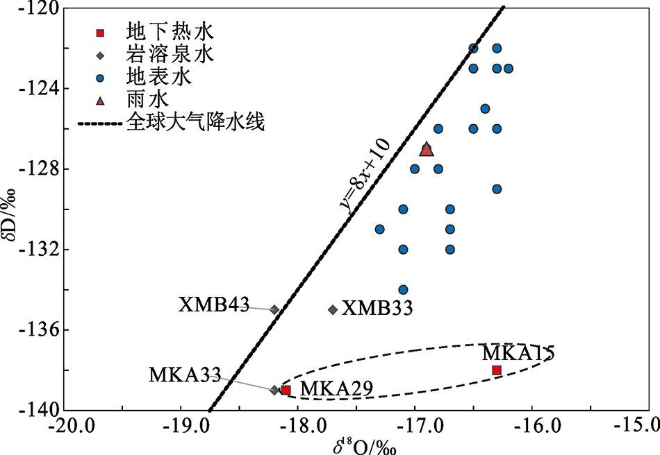
Fig.4 δD vs. δ18O plot of water samples from the study area
| 水样类型 | 标高/m | δD/‰ | 补给高程/m (据δD值) | 取值/m |
|---|---|---|---|---|
| 鲁江热水 | 3 660 | -138 | 4 146 | 4 146 |
| 娘曲热水 | 3 670 | -139 | 4 185 | 4 185 |
Table 2 Elevation calculation for hot-spring recharge area
| 水样类型 | 标高/m | δD/‰ | 补给高程/m (据δD值) | 取值/m |
|---|---|---|---|---|
| 鲁江热水 | 3 660 | -138 | 4 146 | 4 146 |
| 娘曲热水 | 3 670 | -139 | 4 185 | 4 185 |
| 水样类型 | 水温/℃ | 计算热储温度/℃ | 公式(3)和(4) 平均温度 | |
|---|---|---|---|---|
| 公式(3) | 公式(4) | |||
| 鲁江热水 | 24 | 53.0 | 53.3 | 53.1 |
| 娘曲热水 | 36 | 61.0 | 60.9 | 61.0 |
Table 3 Temperature calculation of the geothermal reservoir
| 水样类型 | 水温/℃ | 计算热储温度/℃ | 公式(3)和(4) 平均温度 | |
|---|---|---|---|---|
| 公式(3) | 公式(4) | |||
| 鲁江热水 | 24 | 53.0 | 53.3 | 53.1 |
| 娘曲热水 | 36 | 61.0 | 60.9 | 61.0 |
| 温度/ ℃ | 焓/ (4.1868 J/g) | SiO2含量/ (mg/L) | 温度/ ℃ | 焓/ (4.1868 J/g) | SiO2含量/ (mg/L) |
|---|---|---|---|---|---|
| 50 | 50.0 | 13.5 | 200 | 203.6 | 265 |
| 75 | 75.0 | 26.6 | 225 | 230.9 | 365 |
| 100 | 100.1 | 48.0 | 250 | 259.2 | 486 |
| 125 | 125.4 | 80.0 | 275 | 289.0 | 614 |
| 150 | 151.0 | 125.0 | 300 | 321.0 | 692 |
| 175 | 177.0 | 185.0 |
Table 4 Empirical values of temperature, enthalpy and SiO2 contents of thermal groundwater[19]
| 温度/ ℃ | 焓/ (4.1868 J/g) | SiO2含量/ (mg/L) | 温度/ ℃ | 焓/ (4.1868 J/g) | SiO2含量/ (mg/L) |
|---|---|---|---|---|---|
| 50 | 50.0 | 13.5 | 200 | 203.6 | 265 |
| 75 | 75.0 | 26.6 | 225 | 230.9 | 365 |
| 100 | 100.1 | 48.0 | 250 | 259.2 | 486 |
| 125 | 125.4 | 80.0 | 275 | 289.0 | 614 |
| 150 | 151.0 | 125.0 | 300 | 321.0 | 692 |
| 175 | 177.0 | 185.0 |
| 温度 /℃ | Sc | Sh | Ss | C(SiO2) | S(SiO2) | h(SiO2) | X1 | X2 |
|---|---|---|---|---|---|---|---|---|
| 50 | 4.15 | 50.0 | 18.1 | 3 | 15.1 | 13.5 | 0.70 | -0.15 |
| 75 | 4.15 | 75.0 | 18.1 | 3 | 15.1 | 26.6 | 0.80 | 0.49 |
| 100 | 4.15 | 100.1 | 18.1 | 3 | 15.1 | 48.0 | 0.85 | 0.73 |
| 125 | 4.15 | 125.4 | 18.1 | 3 | 15.1 | 80.0 | 0.88 | 0.84 |
| 150 | 4.15 | 151.0 | 18.1 | 3 | 15.1 | 125.0 | 0.91 | 0.90 |
| 175 | 4.15 | 177.0 | 18.1 | 3 | 15.1 | 185.0 | 0.92 | 0.93 |
| 200 | 4.15 | 203.6 | 18.1 | 3 | 15.1 | 265.0 | 0.93 | 0.95 |
| 225 | 4.15 | 230.9 | 18.1 | 3 | 15.1 | 365.0 | 0.94 | 0.97 |
| 250 | 4.15 | 259.2 | 18.1 | 3 | 15.1 | 486.0 | 0.95 | 0.97 |
| 275 | 4.15 | 289.0 | 18.1 | 3 | 15.1 | 614.0 | 0.95 | 0.98 |
| 300 | 4.15 | 321.0 | 18.1 | 3 | 15.1 | 692.0 | 0.96 | 0.98 |
Table 5 Mixing ratio calculation results for the Lujiang thermal groundwater
| 温度 /℃ | Sc | Sh | Ss | C(SiO2) | S(SiO2) | h(SiO2) | X1 | X2 |
|---|---|---|---|---|---|---|---|---|
| 50 | 4.15 | 50.0 | 18.1 | 3 | 15.1 | 13.5 | 0.70 | -0.15 |
| 75 | 4.15 | 75.0 | 18.1 | 3 | 15.1 | 26.6 | 0.80 | 0.49 |
| 100 | 4.15 | 100.1 | 18.1 | 3 | 15.1 | 48.0 | 0.85 | 0.73 |
| 125 | 4.15 | 125.4 | 18.1 | 3 | 15.1 | 80.0 | 0.88 | 0.84 |
| 150 | 4.15 | 151.0 | 18.1 | 3 | 15.1 | 125.0 | 0.91 | 0.90 |
| 175 | 4.15 | 177.0 | 18.1 | 3 | 15.1 | 185.0 | 0.92 | 0.93 |
| 200 | 4.15 | 203.6 | 18.1 | 3 | 15.1 | 265.0 | 0.93 | 0.95 |
| 225 | 4.15 | 230.9 | 18.1 | 3 | 15.1 | 365.0 | 0.94 | 0.97 |
| 250 | 4.15 | 259.2 | 18.1 | 3 | 15.1 | 486.0 | 0.95 | 0.97 |
| 275 | 4.15 | 289.0 | 18.1 | 3 | 15.1 | 614.0 | 0.95 | 0.98 |
| 300 | 4.15 | 321.0 | 18.1 | 3 | 15.1 | 692.0 | 0.96 | 0.98 |
| 温度 /℃ | Sc | Sh | Ss | C(SiO2) | S(SiO2) | h(SiO2) | X1 | X2 |
|---|---|---|---|---|---|---|---|---|
| 50 | 4.15 | 50.0 | 30.98 | 3 | 18.7 | 13.5 | 0.41 | -0.50 |
| 75 | 4.15 | 75.0 | 30.98 | 3 | 18.7 | 26.6 | 0.62 | 0.33 |
| 100 | 4.15 | 100.1 | 30.98 | 3 | 18.7 | 48.0 | 0.72 | 0.65 |
| 125 | 4.15 | 125.4 | 30.98 | 3 | 18.7 | 80.0 | 0.78 | 0.80 |
| 150 | 4.15 | 151.0 | 30.98 | 3 | 18.7 | 125.0 | 0.82 | 0.87 |
| 175 | 4.15 | 177.0 | 30.98 | 3 | 18.7 | 185.0 | 0.84 | 0.91 |
| 200 | 4.15 | 203.6 | 30.98 | 3 | 18.7 | 265.0 | 0.87 | 0.94 |
| 225 | 4.15 | 230.9 | 30.98 | 3 | 18.7 | 365.0 | 0.88 | 0.96 |
| 250 | 4.15 | 259.2 | 30.98 | 3 | 18.7 | 486.0 | 0.89 | 0.97 |
| 275 | 4.15 | 289.0 | 30.98 | 3 | 18.7 | 614.0 | 0.91 | 0.97 |
| 300 | 4.15 | 321.0 | 30.98 | 3 | 18.7 | 692.0 | 0.92 | 0.98 |
Table 6 Mixing ratio calculation results for the Niangqu thermal groundwater
| 温度 /℃ | Sc | Sh | Ss | C(SiO2) | S(SiO2) | h(SiO2) | X1 | X2 |
|---|---|---|---|---|---|---|---|---|
| 50 | 4.15 | 50.0 | 30.98 | 3 | 18.7 | 13.5 | 0.41 | -0.50 |
| 75 | 4.15 | 75.0 | 30.98 | 3 | 18.7 | 26.6 | 0.62 | 0.33 |
| 100 | 4.15 | 100.1 | 30.98 | 3 | 18.7 | 48.0 | 0.72 | 0.65 |
| 125 | 4.15 | 125.4 | 30.98 | 3 | 18.7 | 80.0 | 0.78 | 0.80 |
| 150 | 4.15 | 151.0 | 30.98 | 3 | 18.7 | 125.0 | 0.82 | 0.87 |
| 175 | 4.15 | 177.0 | 30.98 | 3 | 18.7 | 185.0 | 0.84 | 0.91 |
| 200 | 4.15 | 203.6 | 30.98 | 3 | 18.7 | 265.0 | 0.87 | 0.94 |
| 225 | 4.15 | 230.9 | 30.98 | 3 | 18.7 | 365.0 | 0.88 | 0.96 |
| 250 | 4.15 | 259.2 | 30.98 | 3 | 18.7 | 486.0 | 0.89 | 0.97 |
| 275 | 4.15 | 289.0 | 30.98 | 3 | 18.7 | 614.0 | 0.91 | 0.97 |
| 300 | 4.15 | 321.0 | 30.98 | 3 | 18.7 | 692.0 | 0.92 | 0.98 |
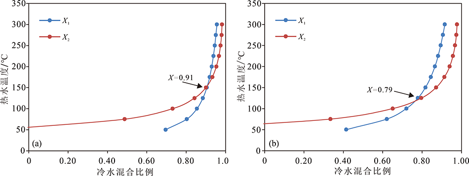
Fig.5 Mixing ratio of cold water in the Lujiang (a) and Niangqu (b) thermal groundwater
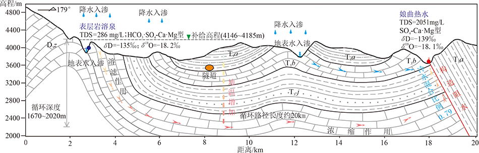
Fig.6 Formation model of the Niangqu geothermal water in Wangka, Chaya
| [1] | 李鹭, 孙占学, 陈功新, 等. 罗溪温泉水文地球化学特征及热水来源[J]. 中国矿业, 2019,28(1):164-169. |
| [2] | 王贵玲, 张薇, 梁继运, 等. 中国地热资源潜力评价[J]. 地球学报, 2017,38(4):449-459. |
| [3] | 王婉丽, 王贵玲, 朱喜, 等. 中国省会城市浅层地热能开发利用条件及潜力评价[J]. 中国地质, 2017,44(6):1062-1073. |
| [4] | 田廷山, 李明朗, 白冶. 中国地热资源及开发利用[M]. 北京: 中国环境科学出版社, 2006: 110. |
| [5] | 刘晓农. 我国温泉旅游的发展路径[J]. 湖南科技大学学报(社会科学版), 2019,22(6):179-184. |
| [6] | 郭忠杰, 王锦国, 陈舟, 等. 云南省鹤庆西山温水龙潭温泉成因机制探讨[J]. 工程勘察, 2015,43(5):43-48,98. |
| [7] | 杜桂林, 曹文海, 翟滨. 威海市宝泉汤温泉成因及其对断裂和地震活动性的影响[J]. 海洋地质与第四纪地质, 2012,32(5):67-72. |
| [8] | 王贵玲, 张薇, 蔺文静, 等. 京津冀地区地热资源成藏模式与潜力研究[J]. 中国地质, 2017,44(6):1074-1085. |
| [9] | 袁星芳, 王敬, 霍光, 等. 胶东半岛洪水岚汤温泉水化学特征与成因分析[J]. 地质与勘探, 2020,56(2):427-437. |
| [10] | 高福兴. 黔东南州北西部温泉地热水水化学及同位素特征研究[J]. 西部资源, 2018(4):117-118,120. |
| [11] | 高志友, 尹观, 范晓, 等. 四川稻城地热资源的分布特点及温泉水的同位素地球化学特征[J]. 矿物岩石地球化学通报, 2004,23(2):134-139. |
| [12] | 谭梦如, 周训, 张彧齐, 等. 云南勐海县勐阿街温泉水化学和同位素特征及成因[J]. 水文地质工程地质, 2019,46(3):70-80. |
| [13] |
CRAIG H. Isotopic variations in meteoric waters[J]. Science, 1961,133:1702-1703.
DOI URL PMID |
| [14] |
CRAIG H. Standard for reporting concentrations of deuterium and oxygen-18 in natural waters[J]. Science, 1961,133:1833-1834.
URL PMID |
| [15] | YU J S, ZHANG H B, YU F J, et al. Oxygen and hydrogen isotopic compositions of meteoric waters in the eastern part of Xizang[J]. Geochemistry, 1984,3(2):93-101. |
| [16] | FOURNIER R O. Chemical geothermometers and mixing models for geothermal systems[J]. Geothermics, 1977,5(1/2/3/4):41-50. |
| [17] | GIGGENBACH W F. Geothermal solute equilibria, derivation of Na-K-Mg-Ca geoindicators[J]. Geochimica et Cosmochimica Acta, 1988,52(12):2749-2765. |
| [18] | LIU Y P, ZHOU X, FANG B, et al. A preliminary analysis of the formation of travertine and travertine cones in the Jifei hot spring, Yunnan, China[J]. Environmental Earth Sciences, 2012,66(7):1887-1896. |
| [19] | 朱炳球, 朱立新, 史长义, 等. 地热田地球化学勘查[M]. 北京: 地质出版社, 1992: 83-95. |
| [20] | 中国地质大学地热开发研究所. 地温梯度, 你想知道的都在这里[EB/OL]. [ 2020- 01- 16]. http://www.hbddrn.com/drnkf/8152.html. |
| [1] | WU Tonghang, LIU Haiyan, ZHANG Weimin, SUN Zhanxue, WANG Zhen, LIU Maohan. Hydrochemical Characteristics and Human Health Risk Assessment in Downstream Ganjiang River of the Poyang Lake Basin [J]. Geoscience, 2022, 36(02): 427-438. |
| [2] | HU Zexiang, ZHAO Xueqin, LI Song, LI Junya, WANG Yujue, YANG Luo. Geothermal Hydrogeochemical Characteristics and Genetic Analysis of the Seda-Songpan Fault Block [J]. Geoscience, 2022, 36(02): 484-493. |
| [3] | WANG Chao, WANG Ruiting, LIU Yunhua, XUE Yushan, HU Xishun, NIU Liang. Fluid Inclusion and C-H-O-S Stable Isotopic Studies of Sanguanmiao Gold Deposit, Shangnan, Shaanxi Province [J]. Geoscience, 2021, 35(06): 1551-1564. |
| [4] | JIANG Suyang, HUANG Wenhui, ZHANG Yongsheng. Geochemical Characteristics of Middle Ordovician in Western Margin of Ordos Basin and Its Implication on Paleoenvironment [J]. Geoscience, 2020, 34(03): 545-553. |
| [5] | LI Na, ZHOU Xun, GUO Juan, TA Mingming, XU Yanqiu. Characteristics and Formation of Salty Springs in Yanyuan County of Sichuan [J]. Geoscience, 2020, 34(01): 177-188. |
| [6] | HUO Dongxue, ZHOU Xun, LIU Haisheng, YU Mingxiao, ZHANG Yuqi. Characteristics and Formation of the Wangjiazhuang Alkaline Hot Spring in Xiangyun County of Yunnan [J]. Geoscience, 2019, 33(03): 680-690. |
| [7] | LU Sanming, LI Jianshe, RUAN Linsen, ZHAO Lili, HUANG Fan, WANG Bohua, ZHANG Huaidong. The Characteristics of Stable Isotope Geochemistry of Shapinggou Molybdenum Deposit, Anhui Province [J]. Geoscience, 2019, 33(02): 262-270. |
| [8] | XU Hao, ZHANG Chuang, PANG Yaqing, CAO Haojie, LIU Jialin, LIU Wenquan. Characteristics of Ore-forming Fluids of the Changpai Uranium Deposit in Guangdong Province [J]. Geoscience, 2018, 32(05): 902-912. |
| [9] | LAI Xin, PANG Baocheng, LI Yuanqiang, ZHANG Qingwei, LÜ Jiawen, ZHOU Yequan, LI Peirong. Genesis of the Wandao Gold Deposit in Guangxi, China: Evidences from Fluid Inclusions and H-O-S-Pb Isotopes [J]. Geoscience, 2017, 31(05): 1006-1021. |
| [10] | WANG Jieqing, ZHOU Xun, LI Xiaolu, WANG Mengmeng, SHEN Ye, FANG Bin. Hydrochemistry and Formation of the Yangchimi Hot Spring in the Lanping Basin of Yunnan [J]. Geoscience, 2017, 31(04): 822-831. |
| [11] | ZHANG Haoyue, HU Xiaonong, WANG Xusheng. Research on Geomorphologic Evolution of East and West Badain Lake and the Impact on Water Body Features [J]. Geoscience, 2017, 31(02): 406-414. |
| [12] | LI Fei1, LI Shaolong2, ZENG Jianhui1, LIU Jingwang3, LIU Jia1, GE Daiwei1, WANG. Feature of Paleofluids and Present Fluids in the Inner Buried Hill of Niutuozhen Uplift, Baxian Sag [J]. Geoscience, 2016, 30(5): 1115-1123. |
| [13] | ZHANG Haoyue1, ZHANG Xujiao2, LI Chenglu2,HE Zexin2, YE Peisheng3,YE Mengni2. Causes of Lakes in Taerhu in the Hetao Plain, Inner Mongolia [J]. Geoscience, 2016, 30(5): 1170-. |
| [14] | . Formation and Evolution of Main Chemical Components of Surface Water and Groundwater in Turpan Basin [J]. Geoscience, 2016, 30(3): 680-687. |
| [15] | . A Preliminary Discussion on Genesis and Ore-forming Fluid Characteristics of the Xinping Gold Deposit in Pingnan County, Guangxi,China [J]. Geoscience, 2016, 30(1): 29-35. |
| Viewed | ||||||
|
Full text |
|
|||||
|
Abstract |
|
|||||