

现代地质 ›› 2022, Vol. 36 ›› Issue (02): 610-623.DOI: 10.19657/j.geoscience.1000-8527.2021.168
马俊学1( ), 陈剑1(), 崔之久2, 刘蓓蓓3
收稿日期:2021-05-20
修回日期:2022-03-01
出版日期:2022-04-10
发布日期:2022-06-01
通讯作者:
陈剑
作者简介:陈剑,男,教授,博士生导师,1975年出生,地质工程专业,主要从事灾害地貌学、工程地质和地质灾害防治研究。Email:jianchen@cugb.edu.cn。基金资助:
MA Junxue1(), CHEN Jian1(), CUI Zhijiu2, LIU Beibei3
Received:2021-05-20
Revised:2022-03-01
Online:2022-04-10
Published:2022-06-01
Contact:
CHEN Jian
摘要:
青藏高原东南缘岷江上游地区地质环境条件十分复杂,滑坡堵江灾害及堰塞湖溃决事件频发,重建其灾害演化过程对于地区性防灾减灾和风险控制具有重要指导意义。以川西岷江上游叠溪古滑坡堰塞湖为研究对象,首先利用高精度DEM和ArcGIS软件重建了叠溪古堰塞湖的原始规模,其原始最大湖水面积为1.1×10⁷ m2,相应的湖容量为2.9×10⁹ m3;然后采用经验公式法和HEC-RAS一维水力学模型重建叠溪古堰塞湖溃决洪水的水力学特征。计算结果表明,HEC-RAS模拟的最大溃决洪水洪峰流量为73 060 m3/s,与经验公式法计算结果(74 500~76 800 m3/s,平均值76 000 m3/s)非常接近,误差小于5%。对应的最大洪水深度和流速分别为70.1 m和16.78 m/s,模拟河段的洪水淹没范围约为6.08 km2。综合误差分析推测的溃决洪峰流量误差范围为69 000~81 000 m3/s。叠溪古滑坡堰塞湖溃决洪水在世界范围内是十分罕见的,其最直接的影响是在下游数公里范围的河谷内形成大量带状或台阶状的溃坝堆积体和巨砾石堆积“阶地”,且这种影响仍延续至今,这与前人关于高能洪水水文特征和沉积特征的研究认识高度一致,证明本研究成果是非常可靠的。此外,本研究还表明,HEC-RAS一维水力模型可用于高山峡谷地区古滑坡堰塞湖溃决洪水重建研究,可为青藏高原东南缘岷江上游古环境重建和地貌演化提供参考。
中图分类号:
马俊学, 陈剑, 崔之久, 刘蓓蓓. 基于HEC-RAS及GIS的川西叠溪古滑坡堰塞湖溃决洪水重建[J]. 现代地质, 2022, 36(02): 610-623.
MA Junxue, CHEN Jian, CUI Zhijiu, LIU Beibei. HEC-RAS-/GIS-Based Paleohydraulic Reconstruction of the Diexi Ancient Landslide-Dammed Lake Outburst Flood in Western Sichuan Province[J]. Geoscience, 2022, 36(02): 610-623.
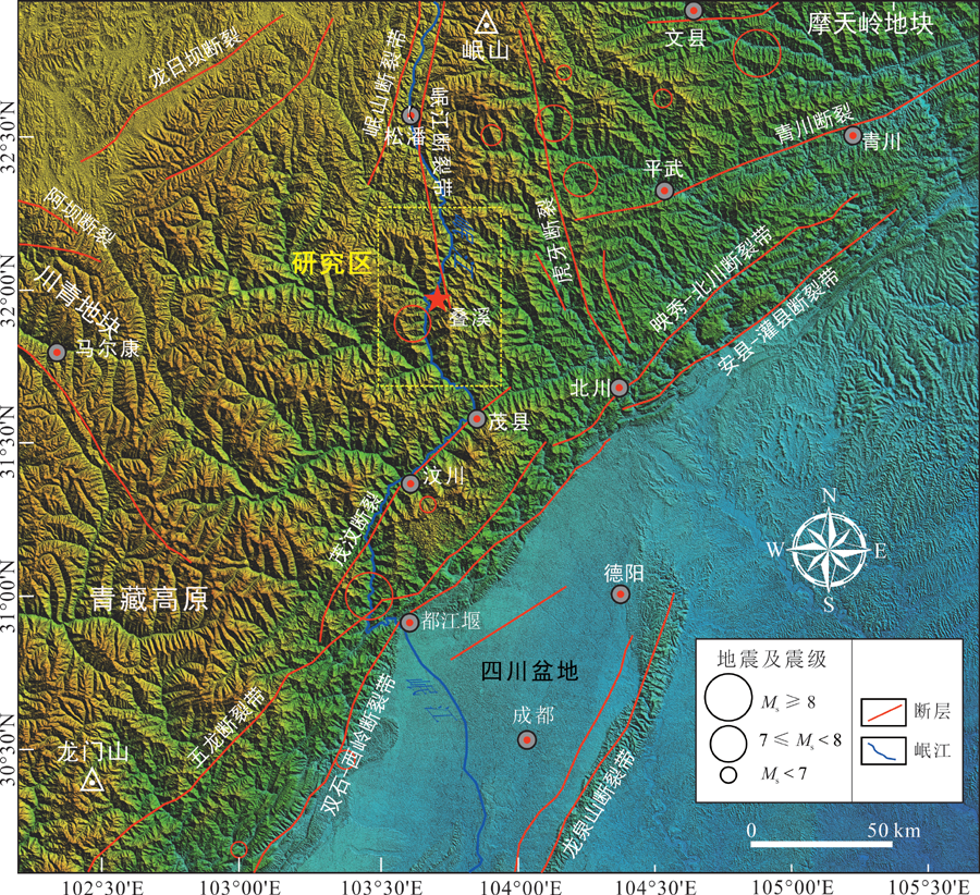
图1 青藏高原东缘构造活动分布及研究区位置图
Fig.1 Outline of the active structures in the Eastern Tibetan Plateau and location of the study area
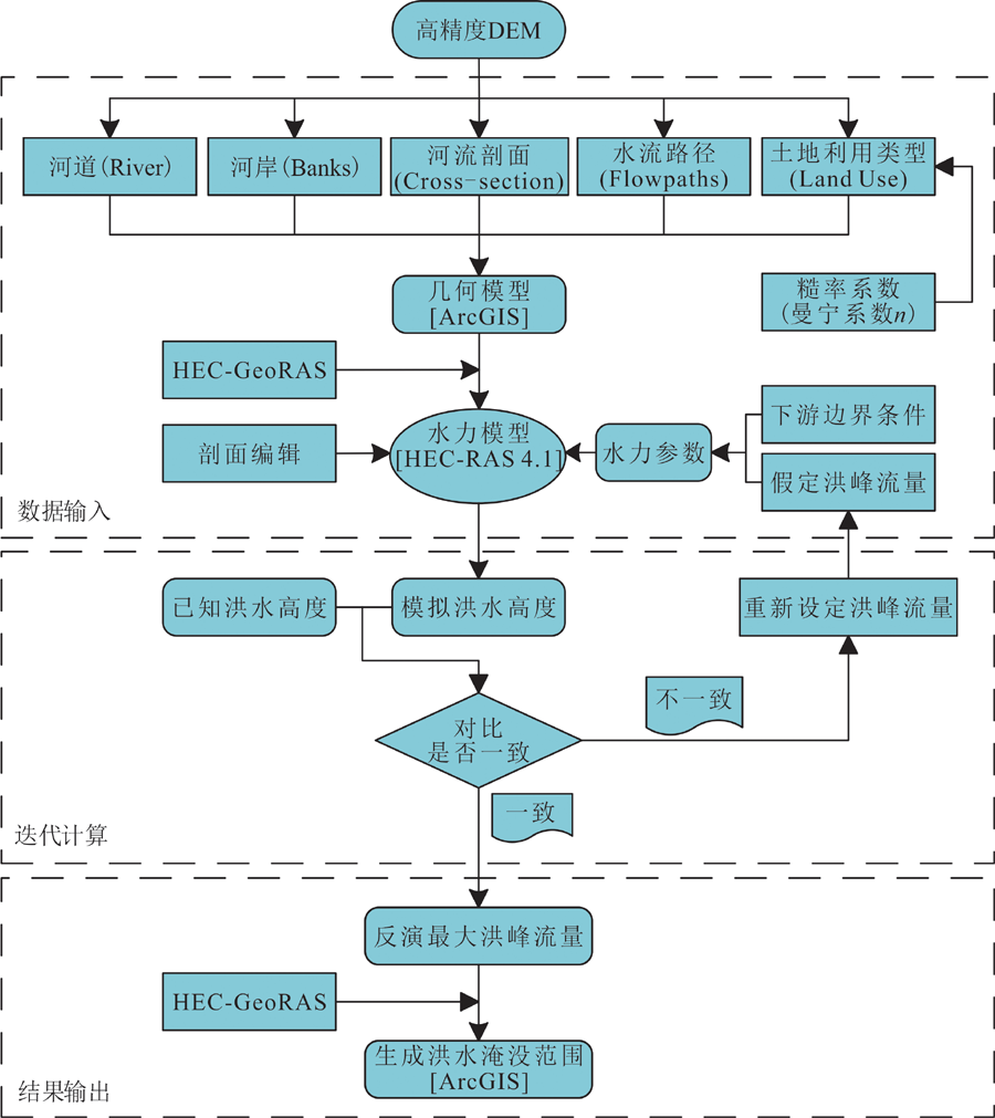
图2 HEC-RAS数值模型溃决洪水重建流程图
Fig.2 Flowchart of the hydraulic reconstruction procedure with the HEC-RAS numerical model
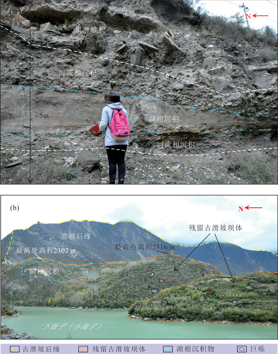
图3 叠溪古滑坡堰塞湖沉积地貌特征 (a)永和村附近叠溪古堰塞湖末端湖相沉积物沉积地貌特征;(b)叠溪残留古滑坡坝体沉积地貌特征(据文献[36]修改)
Fig.3 Sedimentary and geomorphologic characteristics of the Diexi ancient landslide-dammed lake

图4 叠溪古滑坡堰塞湖原始集水面积及湖容量重建(湖水面高程2 355 m)
Fig.4 Map showing the reconstructed original lake surface area and responding volume of the ancient Diexi landslide-dammed lake, with a water surface elevation of 2,355 m a.s.l.
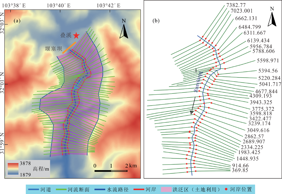
图5 HEC-RAS几何模型 (a)本研究建立的叠溪古堰塞湖溃决洪水反演HEC-RAS几何模型;(b)HEC-RAS软件界面几何模型示意图(单位:m)
Fig.5 HEC-RAS geometric model
| 模型 | 参数 | 取值 | |
|---|---|---|---|
| 几何模型 | DEM分辨率/m | 10×10 | |
| 模拟河段长度/m | 7 615 | ||
| 横剖面数量/条 | 41 | ||
| 剖面线平均间距/m | 190 | ||
| 水力模型 | 粗糙度系数 (曼宁系数) | 河道 | 0.004 |
| 洪泛区 | 0.006 | ||
| 收缩系数 | 0.1 | ||
| 膨胀系数 | 0.3 | ||
| 边界条件 | 上游 | 预设洪峰流量 | |
| 下游 | 河床底坡S = 0.005 m/m | ||
| 洪水流态 | 亚临界稳定流 | ||
表1 叠溪古堰塞湖溃决洪水反演HCE-RAS水力模型输入参数
Table 1 Data input for the HCE-RAS hydraulic reconstruction model of the Diexi ancient LLOF
| 模型 | 参数 | 取值 | |
|---|---|---|---|
| 几何模型 | DEM分辨率/m | 10×10 | |
| 模拟河段长度/m | 7 615 | ||
| 横剖面数量/条 | 41 | ||
| 剖面线平均间距/m | 190 | ||
| 水力模型 | 粗糙度系数 (曼宁系数) | 河道 | 0.004 |
| 洪泛区 | 0.006 | ||
| 收缩系数 | 0.1 | ||
| 膨胀系数 | 0.3 | ||
| 边界条件 | 上游 | 预设洪峰流量 | |
| 下游 | 河床底坡S = 0.005 m/m | ||
| 洪水流态 | 亚临界稳定流 | ||
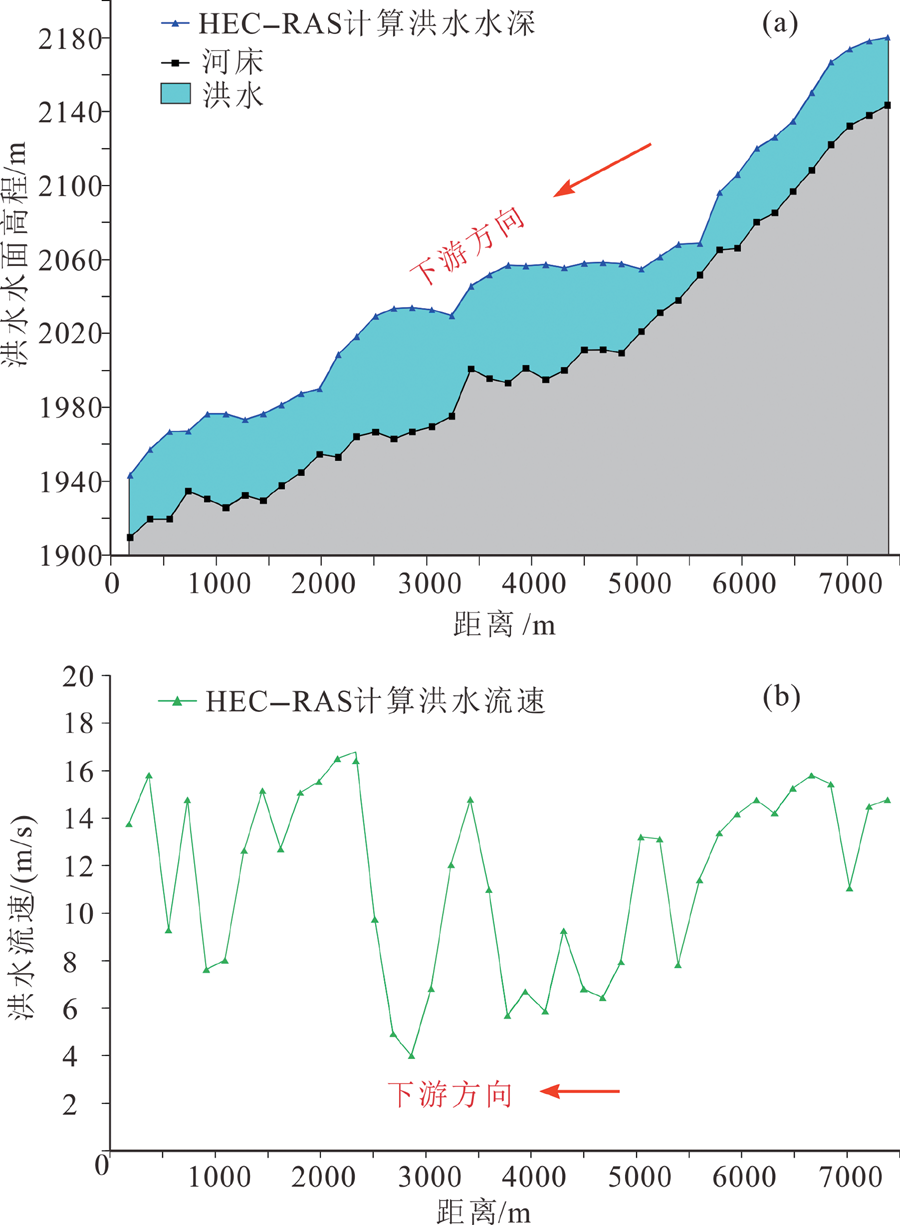
图6 HEC-RAS模拟的叠溪古堰塞湖溃决洪水水面高度及洪水流速 (a)溃决洪水水面高度;(b)溃决洪水流速
Fig.6 Simulated water surface elevations and flow velocities with the HEC-RAS hydraulic model

图7 模拟段叠溪古堰塞湖溃决洪水的淹没范围
Fig.7 Map showing the inundated areas of the Diexi ancient LLOF with a discharge of 73,060 m3/s
| 输入 参数 | 初始值 | 改变量/cm | 洪峰流量 | ||
|---|---|---|---|---|---|
| 计算值/ (m3/s) | 变化量/ (m3/s) | 相对误 差/% | |||
| 水面 高度 | 2 106 m | +10 | 73 580 | +520 | +0.71 |
| -10 | 72 500 | -560 | -0.77 | ||
| +30 | 74 470 | +1 410 | +2.24 | ||
| -30 | 71 618 | -1 442 | -2.29 | ||
| +50 | 75 500 | +2 440 | +3.87 | ||
| -50 | 70 650 | -2 410 | -3.82 | ||
| +100 | 77 880 | +4 820 | +7.64 | ||
| -100 | 68 290 | -4 770 | -7.56 | ||
| 曼宁系 数(n) | 河道0.04, 洪泛区 0.06 | +10%(河道0.044,洪泛区0.066) | 55 632 | -7 428 | -11.78 |
| -10%(河道0.036,洪泛区0.054) | 81 820 | +8 760 | +11.99 | ||
| 下游边 界条件 | 河床底坡 S=0.005 m/m | +10%(0.005 5) | 73 070 | +10 | +0.02 |
| -10%(0.004 5) | 73 020 | -40 | -0.06 | ||
| +20%(0.006) | 73 078 | +18 | +0.03 | ||
| -20%(0.004) | 73 010 | -50 | -0.08 | ||
| 横剖面 数量 | 41条 | 87条 | 51 621 | -11 439 | -18.14 |
| 28条 | 83 648 | +10 588 | +16.79 | ||
| 水流方向 | 弯曲型 | 相对平直型 | 73 060 | 0 | 0 |
| DEM 分辨率 | 10 m×10 m | 30 m×30 m | 72 945 | -115 | -0.18 |
表2 叠溪古堰塞湖溃决洪水HEC-RAS模拟结果灵敏度分析
Table 2 Sensitivity assessment on the HEC-RAS results for the Diexi ancient LLOF
| 输入 参数 | 初始值 | 改变量/cm | 洪峰流量 | ||
|---|---|---|---|---|---|
| 计算值/ (m3/s) | 变化量/ (m3/s) | 相对误 差/% | |||
| 水面 高度 | 2 106 m | +10 | 73 580 | +520 | +0.71 |
| -10 | 72 500 | -560 | -0.77 | ||
| +30 | 74 470 | +1 410 | +2.24 | ||
| -30 | 71 618 | -1 442 | -2.29 | ||
| +50 | 75 500 | +2 440 | +3.87 | ||
| -50 | 70 650 | -2 410 | -3.82 | ||
| +100 | 77 880 | +4 820 | +7.64 | ||
| -100 | 68 290 | -4 770 | -7.56 | ||
| 曼宁系 数(n) | 河道0.04, 洪泛区 0.06 | +10%(河道0.044,洪泛区0.066) | 55 632 | -7 428 | -11.78 |
| -10%(河道0.036,洪泛区0.054) | 81 820 | +8 760 | +11.99 | ||
| 下游边 界条件 | 河床底坡 S=0.005 m/m | +10%(0.005 5) | 73 070 | +10 | +0.02 |
| -10%(0.004 5) | 73 020 | -40 | -0.06 | ||
| +20%(0.006) | 73 078 | +18 | +0.03 | ||
| -20%(0.004) | 73 010 | -50 | -0.08 | ||
| 横剖面 数量 | 41条 | 87条 | 51 621 | -11 439 | -18.14 |
| 28条 | 83 648 | +10 588 | +16.79 | ||
| 水流方向 | 弯曲型 | 相对平直型 | 73 060 | 0 | 0 |
| DEM 分辨率 | 10 m×10 m | 30 m×30 m | 72 945 | -115 | -0.18 |
| 计算方法 | 参数 | 初始值 | 改变量 | 洪峰流量 | |||||
|---|---|---|---|---|---|---|---|---|---|
| 初始值/ (m3/s) | 计算值/ (m3/s) | 变化量/ (m3/s) | 相对误 差/% | 备注 | |||||
| 线性回 归方程 | 公式(1)[ | 堰塞湖库 容量(Vw) | 2.9×10⁹ m3 | +10% | 74 500 | 78 405 | +3 905 | +5.38 | 理想误差范围 |
| -10% | 70 494 | -4 006 | -5.11 | ||||||
| +20% | 82 105 | +7 605 | +10.79 | 最大可接受 误差范围 | |||||
| -20% | 66 228 | -8 272 | -10.08 | ||||||
| 公式(2)[ | 堰塞湖库 容量(V) | 2.9×10⁹ m3 | +10% | 76 600 | 80 024 | +3 424 | +4.58 | 理想误差范围 | |
| -10% | 72 968 | -3 632 | -4.54 | ||||||
| +20% | 83 292 | +6 692 | +9.17 | 最大可接受 误差范围 | |||||
| -20% | 69 120 | -7 480 | -8.98 | ||||||
| 简易参 数方程 | 公式(3)[ | 溃决 高度(d) | 53 m | +3 m | 76 800 | 88 159 | +11 359 | +14.79 | 理想误差范围 |
| -3 m | 66 408 | -10 392 | -13.53 | ||||||
| +5 m | 96 242 | +19 442 | +25.31 | 最大可接受 误差范围 | |||||
| -5 m | 59 965 | -16 835 | -21.92 | ||||||
表3 经验方法溃决洪峰流量误差分析
Table 3 Uncertainty assessment of the outburst flood peak discharge
| 计算方法 | 参数 | 初始值 | 改变量 | 洪峰流量 | |||||
|---|---|---|---|---|---|---|---|---|---|
| 初始值/ (m3/s) | 计算值/ (m3/s) | 变化量/ (m3/s) | 相对误 差/% | 备注 | |||||
| 线性回 归方程 | 公式(1)[ | 堰塞湖库 容量(Vw) | 2.9×10⁹ m3 | +10% | 74 500 | 78 405 | +3 905 | +5.38 | 理想误差范围 |
| -10% | 70 494 | -4 006 | -5.11 | ||||||
| +20% | 82 105 | +7 605 | +10.79 | 最大可接受 误差范围 | |||||
| -20% | 66 228 | -8 272 | -10.08 | ||||||
| 公式(2)[ | 堰塞湖库 容量(V) | 2.9×10⁹ m3 | +10% | 76 600 | 80 024 | +3 424 | +4.58 | 理想误差范围 | |
| -10% | 72 968 | -3 632 | -4.54 | ||||||
| +20% | 83 292 | +6 692 | +9.17 | 最大可接受 误差范围 | |||||
| -20% | 69 120 | -7 480 | -8.98 | ||||||
| 简易参 数方程 | 公式(3)[ | 溃决 高度(d) | 53 m | +3 m | 76 800 | 88 159 | +11 359 | +14.79 | 理想误差范围 |
| -3 m | 66 408 | -10 392 | -13.53 | ||||||
| +5 m | 96 242 | +19 442 | +25.31 | 最大可接受 误差范围 | |||||
| -5 m | 59 965 | -16 835 | -21.92 | ||||||
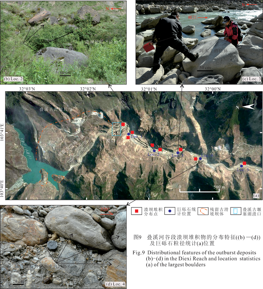
图9 叠溪河谷段溃坝堆积物的分布特征((b)——(d))及巨硕石粒径统计(a)位置
Fig.9 Distributional features of the outburst deposits (b)-(d) in the Diexi Reach and location statistics (a) of the largest boulders
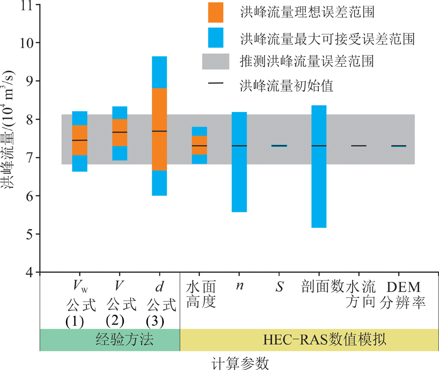
图8 叠溪古堰塞湖溃决洪峰流量误差分析
Fig.8 Uncertainty assessment of the peak discharge of the Diexi ancient LLOF
| 参数 | 统计位置 | ||||
|---|---|---|---|---|---|
| Loc.1 | Loc.2 | Loc.3 | Loc.4 | Loc.5 | |
| 统计数量 | 36 | 30 | 30 | 40 | 38 |
| 最大平均粒径/m | 4.3 | 3.6 | 2.9 | 1.9 | 1.7 |
表4 叠溪古滑坡残留坝体下游河道最大砾石直径统计
Table 4 Statistics of the largest boulder diameter along the downstream channels of the relict Diexi paleo-landslide dam
| 参数 | 统计位置 | ||||
|---|---|---|---|---|---|
| Loc.1 | Loc.2 | Loc.3 | Loc.4 | Loc.5 | |
| 统计数量 | 36 | 30 | 30 | 40 | 38 |
| 最大平均粒径/m | 4.3 | 3.6 | 2.9 | 1.9 | 1.7 |
| [1] | 张岩, 朱利东, 杨文光, 等. 青藏高原东缘叠溪海盆地40-30kaBP高分辨率快速气候变化记录[J]. 地学前缘, 2009, 16(5): 91-98. |
| [2] | 张岳桥, 李海龙, 李建. 青藏高原30-40 ka B.P.暖湿气候事件对川西河谷地质环境的影响[J]. 地球学报, 2016, 37(4): 481-492. |
| [3] | DAI F C, LEE C F, DENG J H, et al. The1786 earthquake-triggered landslide dam and subsequent dam-break flood on the Dadu River, South-western China[J]. Geomorphology, 2005, 65: 205-221. |
| [4] | CHEN J, DAI F C, LV T Y, et al. Holocene landslide-dammed lake deposits in the Upper Jinsha River, SE Tibetan Plateau and their ages[J]. Quaternary International, 2013, 298: 107-113. |
| [5] | 陈剑, 崔之久. 金沙江上游雪隆囊古滑坡堰塞湖溃坝堆积体的发现及其环境与灾害意义[J]. 沉积学报, 2015, 33(2): 275-284. |
| [6] | 张永双, 赵希涛, 胡道功. 滇西北德钦地区金沙江奔子栏古堰塞湖的发现及意义[J]. 地质通报, 2007, 26(8): 970-975. |
| [7] | KORUP O, MONTOMERY D R. Tibetan Plateau river incision inhibited by glacial stabilization of the Tsangpo Gorge[J]. Nature, 2008, 455: 786-789. |
| [8] | 韩建恩, 孟庆伟, 郭长宝, 等. 雅鲁藏布江中游杰德秀古湖的发现及其意义[J]. 现代地质, 2017, 31(5): 890-899. |
| [9] | 柴贺军, 刘汉超. 岷江上游多级多期崩滑堵江事件初步研究[J]. 山地学报, 2002, 20(5): 616-620. |
| [10] | CUI P, DANG C, ZHANG J Q, et al. Landslide-dammed lake at Tangjiashan, Sichuan Province, China (triggered by the Wenchuan Earthquake, May 12, 2008): risk assessment, mitigation strategy, and lessons learned[J]. Environmental Earth Sciences, 2012, 65(4): 1055-1065. |
| [11] | ZHOU J W, CUI P, FANG H. Dynamic process analysis for the formation of Yangjiagou landslide-dammed lake triggered by the Wenchuan Earthquake, China[J]. Landslides, 2013, 10(3): 331-342. |
| [12] | LIU W M, HU K H, CARLING P A, et al. The establishment and influence of Baimakou paleo-dam in an upstream reach of the Yangtze River, southeastern margin of the Tibetan Plateau[J]. Geomorphology, 2018, 321: 167-173. |
| [13] | COSTA J E, SCHUSTER R L. The formation and failure of na-tural dams[J]. Geological Society of America Bulletin, 1988, 100: 1054-1068. |
| [14] | MONTOMERY D R, HALLET B, LIU Y P, et a1. Evidence for Holocene megafloods down the Tsangpo River gorge, Southeastern Tibet[J]. Quaternary Research, 2004, 62(2): 201-207. |
| [15] | CHEN J, ZHOU W, CUI Z J, et al. Formation process of a large paleoland slide-dammed lake at Xuelongnang in the upper Jinsha River, SE Tibetan Plateau: constraints from OSL and 14C dating[J]. Landslides, 2018, 15(12): 2399-2412. |
| [16] | 赵希涛, 曲永新, 张永双, 等. 滇西北丽江地区石鼓古湖的发现及其在现代金沙江河谷发育中的意义[J]. 地质通报, 2007, 26(8): 960-969. |
| [17] | 明庆忠, 潘保田, 苏怀, 等. 金沙江河谷-水系演化的崩滑外动力作用研究[J]. 云南师范大学学报(自然科学版), 2013, 33(5): 1-8. |
| [18] | WANG P F, CHEN J, DAI F C, et al. Chronology of relict lake deposits around the Suwalong paleoland slide in the upper Jinsha River, SE Tibetan Plateau: Implications to Holocene tectonic perturbations[J]. Geomorphology, 2014, 217: 193-203. |
| [19] | 龙维, 陈剑, 王鹏飞, 等. 金沙江上游特米大型古滑坡的成因及古地震参数反分析[J]. 地震研究, 2015, 38(4): 568-575. |
| [20] | 王兰生, 王小群, 许向宁, 等. 岷江上游近两万年前发生了什么事件?[J]. 地学前缘, 2007, 14(4): 189-196. |
| [21] | 程雪峰, 范念念, 刘维明, 等. 两万年来岷江汶川古堰塞湖事件研究[J]. 山地学报, 38(4): 561-570. |
| [22] | 钟湖平, 吉锋. 大渡河加郡古堰塞湖沉积特征及演变过程初探[J]. 中国水运, 2012, 12(4): 182-184. |
| [23] | 李海龙, 张岳桥, 乔彦松, 等. 青藏高原东缘大渡河中游深切河谷沉积物及其地震地质意义[J]. 地质通报, 2015, 34(1): 104-112. |
| [24] | COSTA J E. Paleohydraulic reconstruction of flash-flood peaks from boulder deposits in the Colorado Front Range[J]. Geological Society of American Bulletin, 1983, 94(8): 986-1004. |
| [25] | EVANS S G. The maximum discharge of outburst floods caused by the breaching of man-made and natural dams[J]. Canadian Geotechnical Journal, 1986, 23(3): 385-387. |
| [26] | WALDER J S, OCONNOR J E. Methods for predicting peak discharge of floods caused by failure of natural and constructed earthen dams[J]. Water Resources Research, 1997, 33(10): 2337-2348. |
| [27] | PIERCE M W, THORNTON C I, ABT S R. Predicting peak outflow from breached embankment dams[J]. Journal of Hydrologic Engineering, 2010, 15(5): 338-349. |
| [28] | 郭永强, 葛永刚, 陈晓清, 等. 高山峡谷区古洪水事件重建研究进展[J]. 地学前缘, 2021, 28(2): 168-180. |
| [29] | 王光明, 查小春, 黄春长, 等. HEC-RAS模型在汉江上游洪水演进和流量重建中的应用[J]. 西北农林科技大学学报(自然科学版), 2017, 45(12): 129-137. |
| [30] | ANEES M T, ABDULLAH K, NAWAWI M N M, et al. Numerical modeling techniques for flood analysis[J]. Journal of African Earth Sciences, 2016, 124: 478-486. |
| [31] | RUIZ-BELLET J L, CASTELLTORT X, BALASCH J C, et al. Uncertainty of the peak flow reconstruction of the 1907 flood in the Ebro River in Xerta (NE Iberian Peninsula)[J]. Journal of Hydrology, 2017, 545: 339-354. |
| [32] | BEN KHALFALLAH C, SAIDI S. Spatiotemporal flood plain mapping and prediction using HEC-RAS-GIS tools: Case of the Mejerda River, Tunisia[J]. Journal of African Earth Sciences, 2018, 142: 44-51. |
| [33] | ALHO P, AALTONEN J. Comparing a 1D hydraulic model with a 2D hydraulic model for the simulation of extreme glacial outburst floods[J]. Hydrological Processes, 2008, 22(10): 1537-1547. |
| [34] | WANG P, ZHANG B, QIU W L, et al. Soft-sediment deformation structures from the Diexi paleo-dammed lakes in the upper reaches of the Minjiang River, east Tibet[J]. Journal of Asian Earth Sciences, 2011, 40(4): 865-872. |
| [35] | 范宣梅, 戴岚欣, 钟育瑾, 等. 岷江上游叠溪古滑坡坝--堰塞湖研究进展[J]. 地学前缘, 2021, 28(2): 71-84. |
| [36] | MA J X, CHEN J, CUI Z J, et al. Sedimentary evidence of outburst deposits induced by the Diexi paleolandslide-dammed lake of the upper Minjiang River in China[J]. Quaternary International, 2018, 464: 460-481. |
| [37] | 中华人民共和国区域地质调查报告(1∶200000)松潘幅(I-48-XXXII)、茂汶幅(H-48-II)[R]. 成都:四川省地质局第二区域地质测量队二分队, 1975. |
| [38] | 《四川省阿坝藏族羌族自治州茂汶羌族自治县地方志》编纂委员会. 茂汶羌族自治县志[M]. 成都: 四川辞书出版社, 1997: 90-94. |
| [39] | 马俊学, 陈剑, 崔之久, 等. 堰塞湖溃坝堆积物的粒度特征分析: 以岷江上游叠溪古滑坡堰塞湖为例[J]. 现代地质, 2017, 31(6): 1261-1268. |
| [40] | 马俊学, 陈剑, 崔之久. 岷江上游叠溪混杂堆积体的沉积特征及其成因分析[J]. 沉积学报, 2019, 37(1): 72-85. |
| [41] | WESTOBY M J, GLASSER N F, BRASINGTON J, et al. Mo-delling outburst floods from moraine-dammed glacial lakes[J]. Earth-Science Reviews, 2014, 134: 137-159. |
| [42] | CLAGUE J J, EVANS S G. A review of catastrophic drainage of moraine-dammed lakes in British Columbia[J]. Quaternary Science Reviews, 2000, 19(17/18): 1763-1783. |
| [43] | BUTT M J, UMAR M, QAMAR R. Landslide dam and subsequent dam-break flood estimation using HEC-RAS model in Northern Pakistan[J]. Natural Hazards, 2013, 65(1):241-254. |
| [44] | CENDERELLI D A.Floods from natural and artificial dam failures[M]// WOHL E E. Inland Flood Hazards. Cambridge: Cambridge University Press, 2000: 73-103. |
| [45] | MORRIS M W, HASSAN M, KORTENHAUS A, et al. Modelling breach initiation and growth[R]. Wallingford: HR Wallingford, 2009: 581-591. |
| [46] | CAPART H. Analytical solutions for gradual dam breaching and downstream river flooding[J]. Water Resources Research, 2013, 49(4): 1968-1987. |
| [47] | BRADLEY W C, MEARS A I. Calculations of flows needed to transport coarse fraction of Boulder Creek alluvium at Boulder, Colorado[J]. Geological Society of America Bulletin, 1980, 91: 1057-1090. |
| [48] | US Army Corps of Engineers Hydraulic Engineering Center. HEC-RES River Analysis System User’s Manual Version 4.1[M]. Davis:US Army Corps of Engineers, Institute for Water Resources, Hydraulic Engineering Center (HEC), 2010. |
| [49] | WALDER J S, O’CONNOR J E. Methods for predicting peak discharge of floods caused by failure of natural and constructed earthen dams[J]. Water Resources Research, 1997, 33(10):2337-2348. |
| [50] | BRUNNER G W. HEC-RES River Analysis System Hydraulic Reference Manual[M]. Ver 4.0.Davis:US Army Corps of Engineers, Hydraulic Engineering Center, 2008. |
| [51] | 许强, 郑光, 李为乐, 等. 2018年10月和11月金沙江白格两次滑坡-堰塞堵江事件分析研究[J]. 工程地质学报, 2018, 26(6): 1534-1551. |
| [52] | 余志球, 邓建辉, 高云建, 等. 金沙江白格滑坡及堰塞湖洪水灾害分析[J]. 防灾减灾工程学报, 2020, 40(2): 286-292. |
| [53] | 陈祖煜, 陈生水, 王琳, 等. 金沙江上游“11-03”白格堰塞湖溃决洪水反演分析[J]. 中国科学(技术科学), 2020, 50(6): 763-774. |
| [54] | 谢忱, 陈骎, 侯奇东, 等. 金沙江白格堰塞坝自然泄流冲刷溃决过程数值模拟[J]. 人民长江, 2021, 52(8): 22-29. |
| [55] | HERGET J, FONTANA A. Palaeohydrology:Traces, Tracks and Trails of Extreme Events[M]. Dordrecht: Springer, 2020. |
| [56] | 王昊, 崔鹏, PAUL A C. 高能洪水沉积研究综述[J]. 地学前缘, 2021, 28(2): 140-167. |
| [57] | 张信宝, 刘彧, 胡凯衡. 金沙江折向东流的地质背景、古堰塞湖沉积、第四纪河流演化[J]. 山地学报, 2020, 38(6): 805-815. |
| [58] | 刘青, 王伟, 高星, 等. 大型滑坡坝溃决对下游河谷坡岸的影响分析--以白格滑坡下游50 km内的河谷边坡为例[J]. 山地学报, 2021, 39(2): 226-237. |
| [59] | 陈剑, 崔之久, 陈瑞琛, 等. 金沙江上游特米古滑坡堰塞湖成因与演化[J]. 地学前缘, 2021, 28(2): 85-93. |
| [1] | 金继军, 郭长宝, 沈亚麒, 杨志华, 任三绍, 李雪. 四川茂县周场坪滑坡发育特征与变形监测分析[J]. 现代地质, 2021, 35(01): 103-113. |
| [2] | 吴雨夫, 余斌, 亓星, 褚胜名, 李丽. 岷江上游大白杨沟泥石流特征及成因[J]. 现代地质, 2012, 26(1): 107-113. |
| [3] | 王潜心,陈正阳,龚佑兴. Galileo和GPS组合导航的可行性分析[J]. 现代地质, 2007, 21(Suppl): 139-141. |
| 阅读次数 | ||||||
|
全文 |
|
|||||
|
摘要 |
|
|||||