

现代地质 ›› 2022, Vol. 36 ›› Issue (01): 14-26.DOI: 10.19657/j.geoscience.1000-8527.2021.025
李玮1( ), 屈海英2, 李莎3, 周淑敏1, 宋先腾4, 王晓楠5
收稿日期:2020-10-16
修回日期:2020-12-11
出版日期:2022-02-10
发布日期:2022-03-08
作者简介:李 玮,女,副教授,1989年出生,古生物学与地层学专业,主要从事微体古生物学教学与研究。Email: xiaoweiapple1212@163.com。
基金资助:
LI Wei1(), QU Haiying2, LI Sha3, ZHOU Shumin1, SONG Xianteng4, WANG Xiaonan5
Received:2020-10-16
Revised:2020-12-11
Online:2022-02-10
Published:2022-03-08
摘要:
柴达木盆地贝壳堤保存有大量大小混杂及两壳绞合的双壳类化石,是全球干旱区罕见的地貌景观,为青藏高原东北部中晚更新世的气候与环境演化提供了重要的区域地质记录。该记录在诺木洪西北约20 km出露,将其命名为诺木洪贝壳堤。目前诺木洪贝壳堤的沉积属性存在河湖之争,对该贝壳堤剖面开展系统的介形类分析,建立了8个生物组合带,除1带化石稀少无法鉴定外,2-8带自下而上依次为:Ilyocypris—Candona—Candoniella组合、Ilyocypris—Candona—Leucocythere—Candoniella—Eucypris inflata组合、Leucocythere—Ilyocypris组合、Ilyocypris—Leucocythere—Candoniella—Candona组合、Ilyocypris—Candoniella—Leucocythere组合、Ilyocypris bradyi—Ilyocypris echinata组合和Ilyocypris bradyi—Candoniella组合。根据8个生物组合带的属种特征和古生态指标综合分析贝壳堤水体的演化过程,认为诺木洪贝壳堤为河流相沉积。1-5带沉积期由于频繁的河流改道,贝壳堤剖面处经历牛轭湖-浅水河流多次转变,牛轭湖阶段水体较深不利于介形类生存,而浅水河流阶段介形类相对繁盛;6-8带沉积期水体维持极浅河流状态,介形类繁盛,后因持续干旱河道封闭,水体盐度升高而不利于介形类生存;最终盐壳析出,诺木洪贝壳堤沉积结束。
中图分类号:
李玮, 屈海英, 李莎, 周淑敏, 宋先腾, 王晓楠. 柴达木盆地诺木洪贝壳堤水体演变的介形类证据[J]. 现代地质, 2022, 36(01): 14-26.
LI Wei, QU Haiying, LI Sha, ZHOU Shumin, SONG Xianteng, WANG Xiaonan. Water Evolution of Nuomuhong Shell Ridge in Qaidam Basin: Evidence from Ostracods[J]. Geoscience, 2022, 36(01): 14-26.
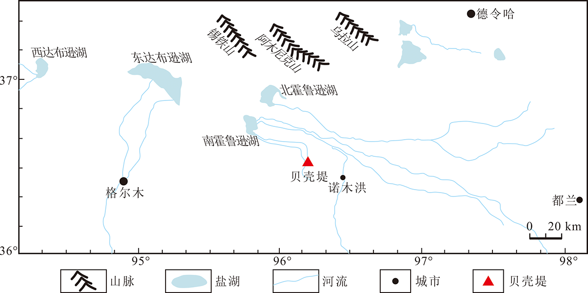
图1 柴达木盆地诺木洪贝壳堤位置
Fig.1 Location of the Nuomuhong Shell Ridge in the Qaidam Basin
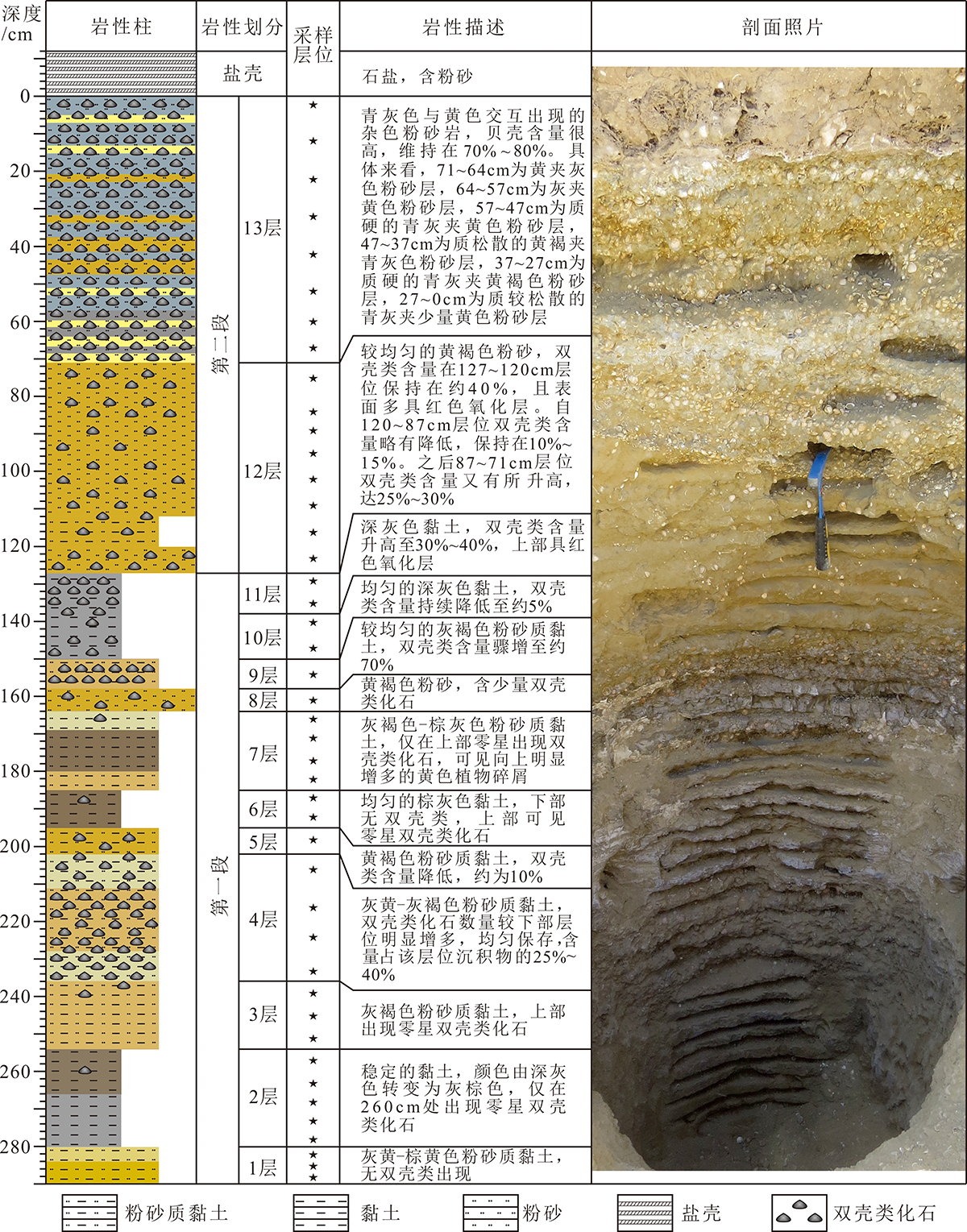
图2 诺木洪贝壳堤剖面岩性划分与描述
Fig.2 Lithostratigraphic division and descriptions of the Nuomuhong Shell Ridge section

图3 诺木洪贝壳堤剖面代表性介形类化石 1. Pseudocandona compressa(Brady),左壳;2. Pseudocandona compressa(Brady),右壳;3. Ilyocypris echinata Huang,左壳;4. Ilyocypris echinata Huang,右壳;5. Eucypris inflata(Sars),左壳;6. Cypricercus berevis Huang,左壳;7. Candona houae Huang,左壳;8. Candona houae Huang,右壳;9-10. Ilyocypris bradyi Sars,左壳;11-12. Ilyocypris bradyi Sars,右壳;13. Candona neglecta Sars,左壳;14. Candona neglecta Sars,右壳;15. Leucocythere dorsotuberosa Huang,左壳;16. Leucocythere dorsotuberosa Huang,右壳;17. Leucocythere tropis Huang,左壳;18. Leucocythere tropis Huang,右壳;19. Ilyocypris biplicata(Koch),左壳;20. Ilyocypris biplicata(Koch),右壳;21. Limnocythere sancti-patricii Brady et Robertson,左壳;22. Candoniella suzini Schneider,左壳;23. Candoniella suzini Schneider,右壳;24. Candoniella albicans(Brady),左壳;25. Candoniella albicans(Brady),右壳;26,29. Limnothere dubiosa Daday,左壳;27. Potamcypris smaragdina,左壳;28,30. Limnothere dubiosa Daday,右壳;31. Cyclocypris serena(Koch),左壳;32. Candona candida(Müller),左壳;33. Candona candida(Müller),右壳;34.介形类未定种
Fig.3 Major ostracod fossils of the Nuomuhong Shell Ridge section

图4 诺木洪贝壳堤剖面介形类主要属种分布与丰度
Fig.4 Distribution and relative abundance of major ostracod genera in the Nuomuhong Shell Ridge section

图5 诺木洪贝壳堤水体环境演变过程
Fig.5 Water evolution of the Nuomuhong Shell Ridge
| [1] |
COLMAN S M, YU S Y, AN Z, et al. Late Cenozoic climate changes in China’s western interior: a review of research on Lake Qinghai and comparison with other records[J]. Quaternary Science Reviews, 2007, 26(17/18): 2281-2300.
DOI URL |
| [2] |
RAJIV S, EDGARDO M L, GERALD C N. Quaternary fluvial systems of tropics: Major issues and status of research[J]. Palaeogeography, Palaeoclimatology, Palaeoecology, 2012, 356/357: 1-15.
DOI URL |
| [3] |
CAO X, NI J, HERZSCHUH U, et al. A Late Quaternary pollen dataset from eastern continental Asia for vegetation and climate reconstruction: Set up and evaluation[J]. Review of Palaeobotany and Palynology, 2013, 194: 21-37.
DOI URL |
| [4] |
CHEN K Z, BOWLER J M. Late Pleistocene evolution of saltlakes in the Qaidam Basin, Qinghai Province, China[J]. Palaeo-geography, Palaeoclimatology, Palaeoecology, 1986, 54(1/4): 87-104.
DOI URL |
| [5] |
LIU Z C, WANG Y J, CHEN Y, et al. Magnetostratigraphy and sedimentologically derived geochronology of the Quaternary lacustrine deposits of a 3000 m thick sequence in the central Qaidam Basin, Western China[J]. Palaeogeography, Palaeoclimatology, Palaeoecology, 1998, 140(1/4): 459-473.
DOI URL |
| [6] |
YANG W B, SPENCER R J, KROUSE H R, et al. Stable isotopes of lake and fluid inclusion brines, Dabusun lake, Qaidam Basin, Western China: Hydrology and paleoclimatology in arid environments[J]. Palaeogeography, Palaeoclimatology, Palaeoecology, 1995, 117(3/4): 279-290.
DOI URL |
| [7] |
WANG J, WANG Y J, LIU Z C, et al. Cenozoic environmental evolution of the Qaidam Basin and its implications for the uplift of the Tibetan Plateau and the drying of central Asia[J]. Palaeogeography, Palaeoclimatology, Palaeoecology, 1999, 152(1): 37-47.
DOI URL |
| [8] | 胡东生, 张华京, 李炳元, 等. 青藏高原腹地湖泊沉积序列与古气候变化[J]. 地质学报, 2000, 74(4):363-369. |
| [9] | 李炳元. 青藏高原大湖期[J]. 地理学报, 2002, 55(2):174-182. |
| [10] |
ZHANG H C, CHANG F Q, LI B, et al. Branched aliphatic alkanes of the Late Pleistocene paleolake deposits from the Qaidam Basin, NE Tibetan Plateau[J]. Chinese Science Bulletin, 2007, 52(9): 1248-1256.
DOI URL |
| [11] |
MIAO Y F, FANG X M, HERRMANN M, et al. Miocene pollen record of KC-1 core in the Qaidam Basin, NE Tibetan Plateau and implications for evolution of the East Asian monsoon[J]. Palaeogeography, Palaeoclimatology, Palaeoecology, 2011, 299: 30-38.
DOI URL |
| [12] |
AN F Y, MA H Z, WEI H C, et al. Distinguishing aeolian signature from lacustrine sediments of the Qaidam Basin in northeastern Qinghai-Tibetan Plateau and its palaeoclimatic implications[J]. Aeolian Research, 2012, 4: 17-30.
DOI URL |
| [13] |
LAI Z P, MISCHKE S, MADSEN D. Paleoenvironmental implications of new OSL dates on the formation of the “Shell Bar” in the Qaidam Basin, northeastern Qinghai-Tibetan Plateau[J]. Journal of Paleolimnology, 2014, 51(2): 197-210.
DOI URL |
| [14] |
WEI H C, FAN Q S, ZHAO Y, et al. A 94-10 ka pollen record of vegetation change in Qaidam Basin, northeastern Tibetan Plateau[J]. Palaeogeography, Palaeoclimatology, Palaeoecology, 2015, 431: 43-52.
DOI URL |
| [15] |
MIAO Y F, FANG X M, LIU Y S, et al. Late Cenozoic pollen concentration in the western Qaidam Basin, northern Tibetan Plateau, and its significance for paleoclimate and tectonics[J]. Review of Palaeobotany and Palynology, 2016, 231: 14-22.
DOI URL |
| [16] | 张虎才, 雷国良, 常凤琴, 等. 柴达木盆地察尔汗贝壳堤剖面年代学研究[J]. 第四纪研究, 2007, 27(4):511-521. |
| [17] | CHEN K Z, BOWLER J M. Preliminary study on sedimentary characteristics and evolution of palaeoclimate of Qarhan Salt Lake in Qaidam Basin[J]. Scientia Sinica(Series B), 1985, 28: 1218-1232. |
| [18] | 牛洁, 张虎才, 常凤琴, 等. 柴达木察尔汗贝壳堤剖面Sr同位素及其环境意义[J]. 高校地质学报, 2007, 13(1):14-22. |
| [19] | 万和文, 唐领余, 张虎才, 等. 柴达木盆地东部36-18 ka B.P.期间的孢粉记录及其气候环境[J]. 第四纪研究, 2008, 28(1):112-121. |
| [20] | 雷国良, 张虎才, 张文翔, 等. 柴达木盆地察尔汗古湖贝壳堤剖面粒度特征及其沉积环境[J]. 沉积学报, 2007, 25(2):274-282. |
| [21] | 常凤琴, 张虎才, 陈玥, 等. 柴达木盆地察尔汗古湖贝壳堤剖面碳酸盐和瓣鳃化石碳氧稳定同位素[J]. 第四纪研究, 2007, 27(3):427-436. |
| [22] | 常凤琴, 张虎才, 陈玥, 等. 柴达木盆地察尔汗古湖贝壳堤剖面沉积地球化学与环境变化[J]. 地球科学--中国地质大学学报, 2008, 33(2):197-204. |
| [23] | 张虎才, 王强, 彭金兰, 等. 柴达木察尔汗盐湖贝壳堤剖面介形类组合及其环境意义[J]. 第四纪研究, 2008, 28(1):103-111. |
| [24] | 蒲阳, 张虎才, 雷国良, 等. 柴达木盆地察尔汗湖区古湖相沉积物中含氮类分子化石的检出[J]. 地球学报, 2010, 31(2):155-162. |
| [25] | 蒲阳, 张虎才, 雷国良, 等. 青藏高原东北部柴达木盆地古湖泊沉积物正构烷烃记录的MIS3晚期气候变化[J]. 中国科学:地球科学, 2010, 40(5):624-631. |
| [26] | 杨明生, 张虎才, 李斌, 等. 柴达木盆地察尔汗古湖相地层正构烷烃与河蚬化石记录的古生态环境[J]. 地球学报, 2011, 32(1):87-94. |
| [27] |
MISCHKE S, LAI Z P, ZHANG C J. Re-assessment of the paleoclimate implications of the shell bar in the Qaidam Basin, China[J]. Journal of Paleolimnology, 2014, 51: 179-195.
DOI URL |
| [28] |
MISCHKE S, MADSEN D, ZHANG C J, et al. Reply to comment by Zhang(2014): the Shell Bar in the Qaidam Basin: fluvial or lake deposit, and OSL versus 14C age data [J]. Journal of Paleolimnology, 2015, 53: 335-344.
DOI URL |
| [29] |
LI W, SONG B, ZHANG S Q, et al. Sporopollen records and implications for surface processes: A case study of Shell Ridge in the Qaidam Basin, Qinghai-Tibetan Plateau[J]. Quaternary International, 2020, 565: 41-53.
DOI URL |
| [30] | 唐领余, 汪世兰. 青海共和盆地共和组孢粉植物群[J]. 古生物学报, 1988, 27(5):583-606. |
| [31] | 陈克造, BOWLER J M, KELTS K. 四万年来青藏高原的气候变迁[J]. 第四纪研究, 1990, 10(1):21-31. |
| [32] | 李炳元, 张青松, 王富葆. 喀喇昆仑山-西昆仑山地区湖泊演化[J]. 第四纪研究, 1991, 10(1):64-71. |
| [33] |
PACHUR H J, WÜNNEMANN B, ZHANG H C. Lake evolution in the Tengger Desert, Northwestern China, during the last 40000 years[J]. Quaternary Research, 1995, 44: 171-180.
DOI URL |
| [34] |
RHODES T E, GASSE F, LIN R F, et al. A Late Pleistocene-Holocene lacustrine record from Lake Manas, Zunggar(northern Xinjiang, Western China)[J]. Palaeogeography, Palaeoclimatology, Palaeoecology, 1996, 120: 105-125.
DOI URL |
| [35] |
SHI Y F, LIU X D, LI B Y, et al. A very strong summer monsoon event during 30-40 ka BP in the Qinghai-Xizang(Tibet) Plateau and its relation to precessional cycle[J]. Chinese Science Bulletin, 1999, 44: 1851-1858.
DOI URL |
| [36] |
SHI Y F, YU G, LIU X D, et al. Reconstruction of the 30-40 ka BP enhanced Indian monsoon climate based on geological records from the Tibetan Plateau[J]. Palaeogeography, Palaeoclimatology, Palaeoecology, 2001, 160: 69-83.
DOI URL |
| [37] |
LEHMKUHL F, HASELEIN F. Quaternary paleoenvironmental change on the Tibetan Plateau and adjacent areas(Western China and Western Mongolia)[J]. Quaternary International, 2000, 65/66: 121-145.
DOI URL |
| [38] | ZHENG M P, MENG Y F, WEI L J. Evidence of the pan-lake stage in the period of 40-28 ka BP on the Qinghai-Tibet Plateau[J]. Acta Geological Sinica, 2000, 74(2): 266-272. |
| [39] |
LI B Y, ZHU L P. “Greatest lake period” and its palaeoenvironment on the Tibetan Plateau[J]. Journal of Geographical Sciences, 2001, 11: 34-42.
DOI URL |
| [40] | ZHU D G, MENG X G, ZHAO X T, et al. Evolution of an ancient large lake in the southeast of the northern Tibetan Plateau[J]. Acta Geological Sinica, 2004, 78(4): 982-992. |
| [41] | 杨俊峰, 卢书炜, 赵虹, 等. 西藏结则茶卡湖岸沉积物中铀系年龄及意义[J]. 地球科学与环境学报, 2006, 28(3):6-10. |
| [42] |
MADSEN D B, MA H, RHODE D, et al. Age constraints on the late Quaternary evolution of Qinghai Lake, Tibetan Plateau[J]. Quaternary Research, 2008, 69: 316-325.
DOI URL |
| [43] | 李世杰, 张宏亮, 施雅风, 等. 青藏高原甜水海盆地MIS 3阶段湖泊沉积与环境变化[J]. 第四纪研究, 2008, 28(1):122-131. |
| [44] | 赵希涛, 郑绵平, 李道明, 等. 青海格尔木三岔河组年龄测定与昆仑古湖发育[J]. 第四纪研究, 2009, 29(1):89-97. |
| [45] |
LI D W, LI Y K, MA B Q, et al. Lake-level fluctuation since the Last Glaciation in Selin Co(lake), Central Tibet, investigated using optically stimulated luminescence dating of beach ridges[J]. Environmental Research Letters, 2009, 4: 045204.
DOI URL |
| [46] |
LIU X J, LAI Z P, FAN Q S, et al. Timing for high lake levels of Qinghai Lake in the Qinghai-Tibetan Plateau since the Last Interglaciation based on quartz OSL dating[J]. Quaternary Geochronology, 2010, 5: 218-222.
DOI URL |
| [47] |
LONG H, LAI Z P, FUCHS M, et al. Palaeodunes intercalated in loess strata from the western Chinese Loess Plateau: timing and palaeoclimatic implications[J]. Quaternary International, 2012, 263: 37-45.
DOI URL |
| [48] |
LONG H, LAI Z P, FUCHS M, et al. Timing of Late Quaternary palaeolake evolution in Tengger Desert of northern China and its possible forcing mechanisms[J]. Global and Planetary Change, 2012, 92/93:119-129.
DOI URL |
| [49] |
LONG H, SHEN J. Underestimated 14C-based chronology of late Pleistocene high lake-level events over the Tibetan Plateau and adjacent areas: evidence from the Qaidam Basin and Tengger Desert[J]. Science China Earth Science, 2015, 58: 183-194.
DOI URL |
| [50] |
ZHANG J R, LAI Z P, JIA Y L. Luminescence chronology for late Quaternary lake levels of enclosed Huangqihai lake in East Asian monsoon marginal area in northern China[J]. Quaternary Geochronology, 2012, 10: 123-128.
DOI URL |
| [51] |
LAI Z P. Chronology and the upper dating limit for loess samples from Luochuan section in Chinese Loess Plateau using quartz OSL SAR protocol[J]. Journal of Asian Earth Sciences, 2010, 37: 176-185.
DOI URL |
| [52] | 王懿瑄. 青藏高原东北部晚第四纪不同类型沉积物光释光年代学研究[D]. 北京: 中国科学院大学, 2019:49-82. |
| [53] |
FAN Y X, LI Z J, YANG G L, et al. Sedimentary evidence and luminescence and ESR dating of Early Pleistocene high lake levels of Megalake Tengger, northwestern China[J]. Journal of Quaternary Science, 2020, 35: 1-13.
DOI URL |
| [54] | 侯佑堂, 勾韵娴, 陈德琼. 中国介形类化石(第一卷)[M]. 北京: 科学出版社, 2002:1-1090. |
| [55] | 侯佑堂, 勾韵娴. 中国介形类化石(第二卷)[M]. 北京: 科学出版社, 2007:1-798. |
| [56] | 青海石油管理局勘探开发研究院, 中国科学院南京地质古生物研究所. 柴达木盆地第三纪介形类动物群[M]. 南京: 南京大学出版社, 1988:1-190. |
| [57] | 王亚琼, 沙金庚, 彭博, 等. Ilyocypris bradyi的轮廓分析[J]. 微体古生物学报, 2011, 28(1):119-126. |
| [58] | 崔莹, 席党鹏, 万晓樵. 大庆油田徐22井青山口组/姚家组微体生物及其古气候响应[J]. 现代地质, 2007, 21(3):484-490. |
| [59] | 孙镇城, 渠永宏, 李东明, 等. 塔里木盆地东北部新生代介形类与沉积环境[J]. 现代地质, 2000, 14(2):123-132. |
| [60] | 杨藩, 乔子真, 张海泉, 等. 柴达木盆地新生代介形类动物群特征及环境意义[J]. 古地理学报, 2006, 8(2):143-156. |
| [61] | 黄宝仁. 柴达木盆地甘森地区介形类化石[J]. 古生物学报, 1964, 12(2):241-255. |
| [62] | 杨藩, 董宁, 乔子真, 等. 青海柴达木盆地与青海湖第四纪介形类Limnocythere的分类与生境[J]. 微体古生物学报, 2008, 25(4):316-332. |
| [63] |
LI X Z, LIU W G, ZHANG L, et al. Distribution of recent ostracod species in the Lake Qinghai area in northwestern China and its ecological significance[J]. Ecological Indicators, 2010, 10: 880-890.
DOI URL |
| [64] | 景民昌, 孙镇城, 李东明, 等. 柴达木盆地3万年左右Ilyocypris inermis灭绝事件及其古环境意义[J]. 现代地质, 2001, 15(1):49-52. |
| [1] | 张金明, 王秉璋, 付彦文, 田成秀. 柴达木盆地及其南北缘前南华纪构造单元划分及地质演化[J]. 现代地质, 2022, 36(05): 1193-1205. |
| [2] | 逯永卓, 韩杰, 王明, 余福承, 王泰山, 袁博武. 柴达木盆地北缘三角顶金矿床成矿特征及其找矿意义[J]. 现代地质, 2021, 35(05): 1363-1370. |
| [3] | 路晶芳, 张克信, 宋博文, 徐亚东, 张楗钰, 黄威, 张道来. 柴达木盆地大红沟地区始新世—上新世孢粉记录及气候变化[J]. 现代地质, 2020, 34(04): 732-744. |
| [4] | 杜江民, 王青春, 聂万才, 罗川又, 李政, 盛军. 白云石有序度对湖相混积碳酸盐岩储集层物性的控制作用:以柴达木盆地英西地区渐新统为例[J]. 现代地质, 2019, 33(03): 643-652. |
| [5] | 曾令旗, 伊海生, 夏国清, 袁桃. 柴达木盆地新生代湖相叠层石沉积序列及古环境意义[J]. 现代地质, 2017, 31(06): 1251-1260. |
| [6] | 黄成刚, 李智勇, 倪祥龙, 马新民, 张世铭, 高妍芳, 杨森, 崔俊, 伍坤宇. 柴达木盆地英西地区 |
| [7] | 伍劲, 高先志, 马达德, 张永庶, 周伟, 牛花朋, 孔红喜, 王波. 柴达木盆地东坪地区基岩风化壳特征[J]. 现代地质, 2017, 31(01): 129-141. |
| [8] | 郭望,张云鹏,李永红,姜亭,杨海星,党洪量. 柴达木盆地北缘侏罗系大煤沟组7段油页岩低放射性控制因素[J]. 现代地质, 2016, 30(4): 905-913. |
| [9] | 王凯霖,金晓媚,郭任宏,魏善蓉,梁华. 柴达木盆地土壤湿度的遥感反演及对蒸散发的影响[J]. 现代地质, 2016, 30(4): 834-841. |
| [10] | 刘峰,崔亚莉,张戈,耿付强,刘洁. 应用氚和14C方法确定柴达木盆地诺木洪地区地下水年龄[J]. 现代地质, 2014, 28(6): 1322-1328. |
| [11] | 苟迎春,曹正林,张小军,万传治,王朴,苏雪迎. 咸化湖盆三角洲沉积模拟实验研究[J]. 现代地质, 2014, 28(6): 1284-1288. |
| [12] | 马新民,刘池洋,罗金海,曾方明,陈大友,张越清. 柴达木盆地上干柴沟组时代归属及代号变更建议[J]. 现代地质, 2014, 28(6): 1266-1274. |
| [13] | 万传治,石亚军, 马新民,吴武军,王鑫. 柴西油砂山地区英北断裂活动时限及形成机制[J]. 现代地质, 2014, 28(2): 308-313. |
| [14] | 司马立强,杨毅,吴丰,姚军朋,赵为永. 柴西北小梁山地区狮子沟组混积岩储层评价[J]. 现代地质, 2014, 28(1): 173-180. |
| [15] | 马新民, 司丹, 马峰, 孙松岭,程玉红, 倪祥龙,张平. 柴达木盆地北缘马北地区古今构造与油气藏的耦合[J]. 现代地质, 2014, 28(1): 131-138. |
| 阅读次数 | ||||||
|
全文 |
|
|||||
|
摘要 |
|
|||||