| [1] |
官厚江. 基于Surpac的菜园子金矿床三维地质建模[D]. 成都:成都理工大学, 2015: 1-4.
|
| [2] |
HOULDING S. 3D Geoscience Modeling: Computer Techniques for Geological Characterization[M]. Berlin: Springer-Verlag, 1994: 1-130.
|
| [3] |
MALLET J L. Discrete smooth interpolation in geometric modelling[J]. Computer Aided Design, 1992,24(4):178-191.
|
| [4] |
LEMON A M, JONES N L. Building solid models from boreholes and user-defined cross-sections[J]. Computers & Geosciences, 2003,29(5):547-555.
|
| [5] |
OLIVIER K, THIERRY M. 3D geological modelling from boreholes, cross-sections and geological maps, application over former natural gas storages in coal mines[J]. Computers & Geosciences, 2008,34(3):278-290.
|
| [6] |
潘懋, 方裕, 屈红刚. 三维地质建模若干基本问题探讨[J]. 地理与地理信息科学, 2007,23(3):1-5.
|
| [7] |
罗智勇, 杨武年. 基于钻孔数据的三维地质建模与可视化研究[J]. 测绘科学, 2008,33(2):130-132.
|
| [8] |
李光强, 陈爱民, 邓敏, 等. 勘探剖面二维坐标系向三维坐标系转换的新方法[J]. 现代地质, 2009,23(3):569-574.
|
| [9] |
陈国良, 刘修国, 盛谦, 等. 一种基于交叉剖面的地质模型构建方法[J]. 岩土力学, 2011,32(8):2409-2415.
|
| [10] |
武强, 徐华. 数字矿山中三维地质建模方法与应用[J]. 中国科学: 地球科学, 2013,43(12):1996-2006.
|
| [11] |
李青元, 张丽云, 魏占营, 等. 三维地质建模软件发展现状及问题探讨[J]. 地质学刊, 2013,37(4):554-561.
|
| [12] |
陈建平, 吕鹏, 吴文, 等. 基于三维可视化技术的隐伏矿体预测[J]. 地学前缘, 2007,14(5):54-62.
|
| [13] |
毛先成, 唐艳华, 赖健清, 等. 凤凰山矿田成矿地质体三维结构与控矿地质因素分析[J]. 地质学报, 2011,85(9):1507-1518.
|
| [14] |
陈建平, 陈勇, 王全明. 基于GIS的多元信息成矿预测研究——以赤峰地区为例[J]. 地学前缘, 2008,15(4):18-26.
|
| [15] |
李晓翠, 刘武生, 贾立城, 等. 鄂尔多斯盆地南部砂岩型铀矿成矿预测[J]. 铀矿地质, 2014,30(6):321-327.
|
| [16] |
袁峰, 李晓晖, 张明明, 等. 隐伏矿体三维综合信息成矿预测方法[J]. 地质学报, 2014,88(4):630-643.
|
| [17] |
胡桥, 陈建平, 田业. 三维成矿预测与预测评价——以东昆仑成矿带红旗沟—深水潭金矿为例[J]. 现代地质, 2018,32(2):335-343.
|
| [18] |
严琼, 陈建平, 尚北川. 云南个旧高松矿田芦塘坝研究区三维预测模型及靶区优选[J]. 现代地质, 2012,26(2):286-293.
|
| [19] |
向杰, 陈建平, 胡桥, 等. 基于矿床成矿系列的三维成矿预测——以安徽铜陵矿集区为例[J]. 现代地质, 2016,30(1):230-238.
|
| [20] |
郑国磊, 徐新学, 袁航, 等. 基于GOCAD软件的天津市大寺新家园——海河教育园区三维可视化建模研究[J]. 地球物理学进展, 2017,32(5):2261-2267.
|
| [21] |
王健, 聂江涛, 田明明, 等. GOCAD的三维可视化建模在铀矿勘查中的应用[J]. 铀矿地质, 2017,33(3):184-188.
|
| [22] |
郭福生, 林子瑜, 黎广荣, 等. 江西相山火山盆地地质结构研究: 来自大地电磁测深及三维地质建模的证据[J]. 地球物理学报, 2017,60(4):1491-1510.
|
| [23] |
侯曼青, 吴志春, 郭福生, 等. 江西乐安邹家山—居隆庵地区三维地质模型的构建[J]. 地质学刊, 2016,40(1):118-124.
|
| [24] |
孔亮, 王功文, 汪程. 基于GOCAD三维地质建模与深部成矿预测——以河南灵宝市灵金一矿为例[J]. 矿物学报, 2015,35(S1):866-867.
|
| [25] |
赵文菊, 王营, 滕寿仁, 等. GOCAD三维可视化在深部地质调查中的应用[J]. 地质与资源, 2015,24(4):378-382,346.
|
| [26] |
赵增玉, 陈火根, 潘懋, 等. 基于GOCAD的宁芜盆地云台山地区三维地质建模[J]. 地质学刊, 2014,38(4):652-656.
|
| [27] |
韩启迪, 王功文, 陈守余, 等. 基于GOCAD软件的区域化探异常三维模拟分析——以云南个旧东部矿区为例[J]. 矿床地质, 2014,33(S1):795-796.
|
| [28] |
杨志华, 兰恒星, 张永双. 基于GIS-GOCAD耦合技术的三维地质建模[J]. 地理与地理信息科学, 2012,28(5):16-20.
|
| [29] |
CAUMON G, DROUAILLET P C, VESLUD C L C D, et al. Surface-based 3D modeling of geological structures[J]. Mathematical Geosciences, 2009,41(8):927-945.
|
| [30] |
SUSINI S, DONATIS M D. 3D model of a sector of the South Scotia Ridge(Antarctica)[J]. Computers & Geosciences, 2009,35(1):83-91.
|
| [31] |
ZANCHI A, FRANCESCA S, STEFANO Z, et al. 3D reconstruction of complex geological bodies: Examples from the Alps[J]. Computers & Geosciences, 2009,35(1):49-69.
|
| [32] |
BENAIZE C G, LAMARCHE J, MASSE J P, et al. 3D structural modelling of small-deformations in poly-phase faults pattern. Application to the Mid-Cretaceous Durance uplift, Provence(SE France)[J]. Journal of Geodynamics, 2010,50(2):81-93.
|
| [33] |
ZHAO K D, JIANG S Y, LING H F, et al. Reliability of LA-ICP-MS U-Pb dating of zircons with high U concentrations: A case study from the U-bearing Douzhashan granite in South China[J]. Chemical Geology, 2014,389:110-121.
|
| [34] |
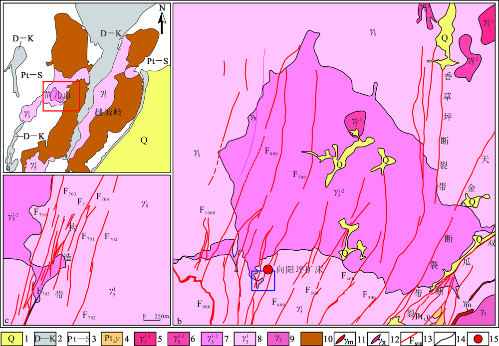
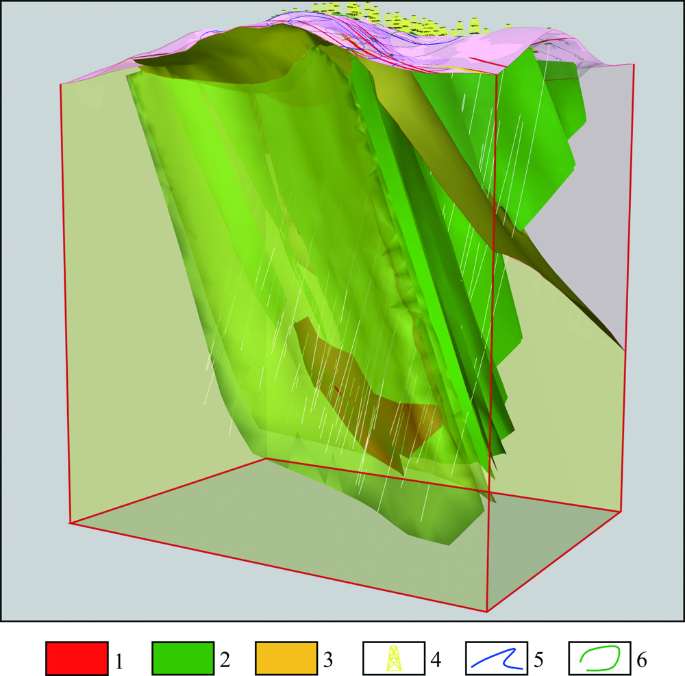
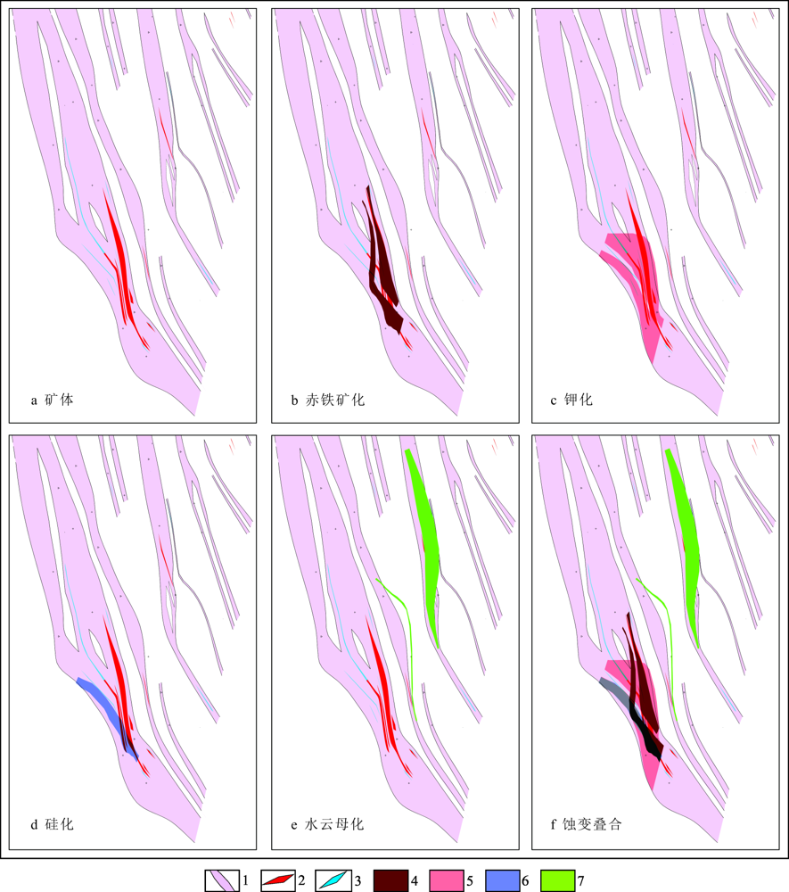
陈琪, 黄剑, 章健, 等. 苗儿山中段向阳坪铀矿床F7号带成矿地质特征及找矿方向[C]. 中国核学会. 中国核科学技术进展报告(第五卷)——中国核学会2017年学术年会论文集第2册(铀矿地质分卷(下)、铀矿冶分卷). 北京: 中国核学会, 2017: 516-524.
|
| [35] |
吴昆明, 李大雁, 陈琪, 等. 广西向阳坪铀矿床成矿地质特征[J]. 铀矿地质, 2016,32(4):224-229,245.
|
| [36] |
张淑虹. 姚家岭锌金多金属矿床蚀变及元素三维空间分布特征和成矿规律研究[D]. 合肥:合肥工业大学, 2014: 41-57.
|
| [37] |
李希, 易鹏飞, 何虎军, 等. 蚀变矿物三维空间模型与找矿预测研究——以吉林某斑岩型钼矿为例[J]. 西北大学学报(自然科学版), 2017,47(1):110-117.
|
 ), 邹明亮1(