欢迎访问现代地质!

现代地质 ›› 2023, Vol. 37 ›› Issue (01): 227-232.DOI: 10.19657/j.geoscience.1000-8527.2023.01.24

• 地球化学与遥感地质 • 上一篇    下一篇

基于中高分辨率数据的内蒙古红石山地区遥感找矿信息提取及找矿预测

连琛芹1,2(), 封志明1,2(), 刘永新3, 雷聪聪3   

  1. 1.中国科学院 地理科学与资源研究所,北京 100101
    2.中国科学院大学,北京 100049
    3.中国地质调查局 呼和浩特自然资源综合调查中心,内蒙古 呼和浩特 010010
  • 收稿日期:2022-01-15 修回日期:2022-11-22 出版日期:2023-02-10 发布日期:2023-03-20
  • 通讯作者: 封志明,男,研究员,1963年出生,自然地理学专业,主要从事资源开发与区域可持续发展的研究工作。Email: fengzm@igsnrr.ac.cn。
  • 作者简介:连琛芹,男,博士研究生,1992年出生,自然资源学专业,主要从事资源遥感研究工作。Email:lianchenqin1911@igsnrr.ac.cn
  • 基金资助:
    科技部第二次青藏高原综合科学考察研究项目(2019QZKK1006)

Remote Sensing Prospecting Information Extraction and Mineral Prediction Based on Medium and High Resolution Data in Hongshishan, Inner Mongolia

LIAN Chenqin1,2(), FENG Zhiming1,2(), LIU Yongxin3, LEI Congcong3   

  1. 1. Institute of Geographic Sciences and Natural Resources Research, Chinese Academy of Sciences, Beijing 100101, China
    2. University of Chinese Academy of Sciences, Beijing 100049, China
    3. Hohhot Natural Resources Comprehensive Survey Center, China Geological Survey, Hohhot, Inner Mongolia 010010, China
  • Received:2022-01-15 Revised:2022-11-22 Online:2023-02-10 Published:2023-03-20

摘要:

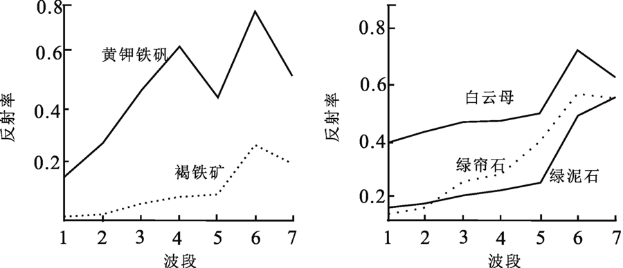
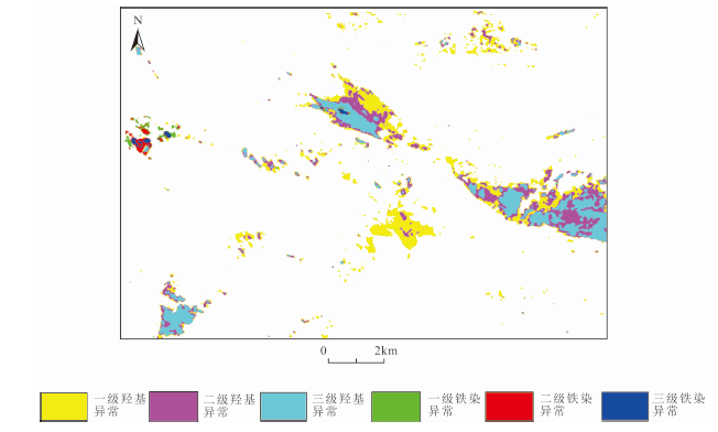
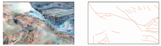
内蒙古红石山地区位于东天山—兴安成矿带内,具有良好的成矿条件,但其位于荒漠戈壁,自然条件恶劣,基础地质研究程度低,因此利用遥感手段进行多金属找矿勘查具有重要意义。采用OLI数据,选择掩膜+无损线性拉伸+特征向量主成分变换+异常切割+异常滤波的方法,提取铁染、羟基等矿化异常信息;选择假彩色合成及线性拉伸,提取断裂构造信息。综合多元信息进行找矿预测,共圈定2处找矿远景区。本次研究对其中1处区域进行进一步重点勘查。重点勘查区域采用高分辨率PLEIADES数据,选择图像融合、彩色合成、直方图拉伸等方法,进一步圈定巨型石英脉体。在重点勘查区域进行野外查证,发现了多处矿化点。此次研究表明综合使用中分辨率OLI数据和高分辨率PLEIADES数据,可以大大提升地质找矿效率,对未来该地区进一步找矿勘查具有重要的指导意义。

关键词: 遥感找矿, 红石山, OLI, PLEIADES, 多金属矿

Abstract:

The Hongshishan area of Inner Mongolia is located in the East Tianshan-Xing’an metallogenic belt and has good metallogenic conditions. However, poor natural conditions and low level of basic geological survey restrict mineral exploration in this area, so it is of great significance to use remote sensing to conduct polymetallic prospecting. OLI data were used in this study, and the mineralization anomalies such as iron stain and hydroxyl group were extracted by mask, lossless linear stretching, eigenvector principal component transformation, density segmentation, anomaly filtering, while the fracture information was extracted by pseudo-color synthesis and linear stretching. Based on the multivariate information, two target areas were delineated and one of them was further explored. High-resolution PLEIADES data, image fusion, color synthesis, histogram stretching and other methods were used to delineate the giant quartz veins in key exploration areas. On the basis of remote sensing interpretation, the field investigation proves that there are several mineralization points in the key exploration area. This study shows that the combination of medium-resolution OLI data and high-resolution PLEIADES data can greatly improve the efficiency of geological prospecting, which has important guiding significance for further prospecting in this area.

Key words: remote sensing prospecting, Hongshishan, OLI, PLEIADES, polymetallic deposit

中图分类号: