

Geoscience ›› 2024, Vol. 38 ›› Issue (03): 599-611.DOI: 10.19657/j.geoscience.1000-8527.2024.040
• Observation Simulation and Prediction Evaluation of Superbiotic Resources • Previous Articles Next Articles
GUO Fuyin1,2,3( ), LIU Xiaohuang1(), ZHANG Wenbo1, XING Liyuan1, WANG Ran1, MAMAT Zulpiya2, LUO Xinping1, WANG Chao1, ZHAO Honghui1
Online:2024-06-10
Published:2024-07-04
CLC Number:
GUO Fuyin, LIU Xiaohuang, ZHANG Wenbo, XING Liyuan, WANG Ran, MAMAT Zulpiya, LUO Xinping, WANG Chao, ZHAO Honghui. Evolution of the Spatial and Temporal Patterns of Habitat Quality and Analysis of the Driving Forces in Yellow River Basin (Henan Section) from 2000 to 2040[J]. Geoscience, 2024, 38(03): 599-611.

Fig.1 Geomorphologic map of the study area
| 数据名称 | 精度 | 格式 | 来源 |
|---|---|---|---|
| 土地利用类型数据(CLCD) | 30 m | FGDBR | Zenodo网站( |
| 道路数据、水系数据 | 矢量 | SHP | OpenStreetmap( |
| 数字高程模型(DEM) | 30 m | TIFF | 地理空间数据云( |
| 降水(Pre) | 500 m | TIFF | GEE( |
| 地表气温(Tem) | |||
| 蒸散发(ET) | |||
| 归一化植被指数(NDVI) | 500 m | TIFF | EARTHDATA( |
| 总初级生产力(GPP) | |||
| 净初级生产力(NPP) | |||
| 土壤质地数据 | 875 m | TIFF | 联合国粮农组织( |
| 国内生产总值(GDP) | 1 km | TIFF | 资源环境科学与数据中心( |
| 人口(Population) | |||
| 行政区划 | 矢量 | SHP | 国家基础地理信息中心( |
Table 1 Data information and sources
| 数据名称 | 精度 | 格式 | 来源 |
|---|---|---|---|
| 土地利用类型数据(CLCD) | 30 m | FGDBR | Zenodo网站( |
| 道路数据、水系数据 | 矢量 | SHP | OpenStreetmap( |
| 数字高程模型(DEM) | 30 m | TIFF | 地理空间数据云( |
| 降水(Pre) | 500 m | TIFF | GEE( |
| 地表气温(Tem) | |||
| 蒸散发(ET) | |||
| 归一化植被指数(NDVI) | 500 m | TIFF | EARTHDATA( |
| 总初级生产力(GPP) | |||
| 净初级生产力(NPP) | |||
| 土壤质地数据 | 875 m | TIFF | 联合国粮农组织( |
| 国内生产总值(GDP) | 1 km | TIFF | 资源环境科学与数据中心( |
| 人口(Population) | |||
| 行政区划 | 矢量 | SHP | 国家基础地理信息中心( |
| 威胁源因子 | 最大影响距离(km) | 权重 | 衰退类型 |
|---|---|---|---|
| 耕地 | 8.0 | 0.7 | 线性衰减 |
| 铁路 | 5.0 | 0.6 | 指数衰减 |
| 建设用地 | 10.0 | 1.0 | 指数衰减 |
| 荒地 | 2.0 | 0.5 | 线性衰减 |
| 一级道路 | 3.0 | 1.0 | 线性衰减 |
| 二级道路 | 1.0 | 0.7 | 线性衰减 |
| 三级道路 | 0.5 | 0.5 | 指数衰减 |
| 四级道路 | 0.2 | 0.3 | 指数衰减 |
Table 2 Parameters of threat factors in the study area
| 威胁源因子 | 最大影响距离(km) | 权重 | 衰退类型 |
|---|---|---|---|
| 耕地 | 8.0 | 0.7 | 线性衰减 |
| 铁路 | 5.0 | 0.6 | 指数衰减 |
| 建设用地 | 10.0 | 1.0 | 指数衰减 |
| 荒地 | 2.0 | 0.5 | 线性衰减 |
| 一级道路 | 3.0 | 1.0 | 线性衰减 |
| 二级道路 | 1.0 | 0.7 | 线性衰减 |
| 三级道路 | 0.5 | 0.5 | 指数衰减 |
| 四级道路 | 0.2 | 0.3 | 指数衰减 |
| 土地利用/覆盖 | 生境适宜度 | 敏感度 | |||||||
|---|---|---|---|---|---|---|---|---|---|
| 耕地 | 铁路 | 建设用地 | 荒地 | 一级道路 | 二级道路 | 三级道路 | 四级道路 | ||
| 耕地 | 0.6 | 0 | 0.35 | 0.50 | 0.4 | 0.3 | 0.2 | 0.1 | 0.05 |
| 林地 | 1.0 | 0.6 | 0.65 | 0.80 | 0.3 | 0.6 | 0.5 | 0.4 | 0.30 |
| 灌木 | 0.9 | 0.4 | 0.45 | 0.60 | 0.3 | 0.4 | 0.3 | 0.2 | 0.10 |
| 草地 | 0.9 | 0.4 | 0.45 | 0.60 | 0.6 | 0.4 | 0.3 | 0.2 | 0.10 |
| 水体 | 0.8 | 0.7 | 0.75 | 0.80 | 0.4 | 0.7 | 0.6 | 0.5 | 0.40 |
| 雪/冰 | 0 | 0 | 0 | 0 | 0.2 | 0 | 0 | 0 | 0 |
| 荒地 | 0.2 | 0.2 | 0.20 | 0.45 | 0 | 0.2 | 0.15 | 0.1 | 0.05 |
| 建设用地 | 0 | 0 | 0 | 0 | 0 | 0 | 0 | 0 | 0 |
Table 3 Sensitivity parameters for each land use type in the study area
| 土地利用/覆盖 | 生境适宜度 | 敏感度 | |||||||
|---|---|---|---|---|---|---|---|---|---|
| 耕地 | 铁路 | 建设用地 | 荒地 | 一级道路 | 二级道路 | 三级道路 | 四级道路 | ||
| 耕地 | 0.6 | 0 | 0.35 | 0.50 | 0.4 | 0.3 | 0.2 | 0.1 | 0.05 |
| 林地 | 1.0 | 0.6 | 0.65 | 0.80 | 0.3 | 0.6 | 0.5 | 0.4 | 0.30 |
| 灌木 | 0.9 | 0.4 | 0.45 | 0.60 | 0.3 | 0.4 | 0.3 | 0.2 | 0.10 |
| 草地 | 0.9 | 0.4 | 0.45 | 0.60 | 0.6 | 0.4 | 0.3 | 0.2 | 0.10 |
| 水体 | 0.8 | 0.7 | 0.75 | 0.80 | 0.4 | 0.7 | 0.6 | 0.5 | 0.40 |
| 雪/冰 | 0 | 0 | 0 | 0 | 0.2 | 0 | 0 | 0 | 0 |
| 荒地 | 0.2 | 0.2 | 0.20 | 0.45 | 0 | 0.2 | 0.15 | 0.1 | 0.05 |
| 建设用地 | 0 | 0 | 0 | 0 | 0 | 0 | 0 | 0 | 0 |

Fig.2 Trends of average annual habitat quality in the study area from 2000 to 2021

Fig.3 Spatial distribution pattern of habitat quality in the study area from 2000 to 2021

Fig.4 Examination of spatial and temporal changes of habitat quality in the study area from 2000 to 2021

Fig.5 Map of land use type shifts in the study area from 2000 to 2021
| 参数 | 气温(X1) | 高程(X2) | 蒸散发(X3) | GDP(X4) | 归一化植被指数(X5) | NPP(X6) | 人口密度(X7) | 降雨量(X8) | GPP(X9) |
|---|---|---|---|---|---|---|---|---|---|
| q值 | 0.31 | 0.32 | 0.21 | 0.13 | 0.40 | 0.21 | 0.23 | 0.11 | 0.20 |
| p值 | 0 | 0 | 0 | 0 | 0 | 0 | 0 | 0 | 0 |
Table 4 One-way detection analysis
| 参数 | 气温(X1) | 高程(X2) | 蒸散发(X3) | GDP(X4) | 归一化植被指数(X5) | NPP(X6) | 人口密度(X7) | 降雨量(X8) | GPP(X9) |
|---|---|---|---|---|---|---|---|---|---|
| q值 | 0.31 | 0.32 | 0.21 | 0.13 | 0.40 | 0.21 | 0.23 | 0.11 | 0.20 |
| p值 | 0 | 0 | 0 | 0 | 0 | 0 | 0 | 0 | 0 |

Fig.6 Heat map of factor interaction detection
| 土地利用 | 2020 | 2025 | 2030 | 2035 | 2040 | |||||||||||
|---|---|---|---|---|---|---|---|---|---|---|---|---|---|---|---|---|
| 生态 | 耕地 | 城市 | 生态 | 耕地 | 城市 | 生态 | 耕地 | 城市 | 生态 | 耕地 | 城市 | |||||
| 耕地 | 38.76 | 37.85 | 37.91 | 37.75 | 36.75 | 37.93 | 36.75 | 35.53 | 38.05 | 35.52 | 34.92 | 38.33 | 34.90 | |||
| 林地 | 14.88 | 15.22 | 15.17 | 15.28 | 15.19 | 14.86 | 15.06 | 15.53 | 14.89 | 15.23 | 15.68 | 14.84 | 15.26 | |||
| 灌木 | 0.05 | 0.04 | 0.04 | 0.03 | 0.05 | 0.03 | 0.04 | 0.04 | 0.05 | 0.04 | 0.03 | 0.03 | 0.04 | |||
| 草地 | 1.59 | 1.24 | 1.31 | 1.25 | 1.32 | 1.38 | 1.39 | 1.24 | 1.47 | 1.33 | 1.24 | 1.36 | 1.32 | |||
| 水体 | 0.65 | 0.66 | 0.65 | 0.66 | 0.66 | 0.66 | 0.65 | 0.67 | 0.66 | 0.66 | 0.67 | 0.66 | 0.67 | |||
| 建设用地 | 10.91 | 11.87 | 11.78 | 11.97 | 12.91 | 12.01 | 12.98 | 13.88 | 11.77 | 14.09 | 14.34 | 11.66 | 14.69 | |||
Table 5 Land use area of different land use scenarios in the study area from 2000 to 2040 (103 km2)
| 土地利用 | 2020 | 2025 | 2030 | 2035 | 2040 | |||||||||||
|---|---|---|---|---|---|---|---|---|---|---|---|---|---|---|---|---|
| 生态 | 耕地 | 城市 | 生态 | 耕地 | 城市 | 生态 | 耕地 | 城市 | 生态 | 耕地 | 城市 | |||||
| 耕地 | 38.76 | 37.85 | 37.91 | 37.75 | 36.75 | 37.93 | 36.75 | 35.53 | 38.05 | 35.52 | 34.92 | 38.33 | 34.90 | |||
| 林地 | 14.88 | 15.22 | 15.17 | 15.28 | 15.19 | 14.86 | 15.06 | 15.53 | 14.89 | 15.23 | 15.68 | 14.84 | 15.26 | |||
| 灌木 | 0.05 | 0.04 | 0.04 | 0.03 | 0.05 | 0.03 | 0.04 | 0.04 | 0.05 | 0.04 | 0.03 | 0.03 | 0.04 | |||
| 草地 | 1.59 | 1.24 | 1.31 | 1.25 | 1.32 | 1.38 | 1.39 | 1.24 | 1.47 | 1.33 | 1.24 | 1.36 | 1.32 | |||
| 水体 | 0.65 | 0.66 | 0.65 | 0.66 | 0.66 | 0.66 | 0.65 | 0.67 | 0.66 | 0.66 | 0.67 | 0.66 | 0.67 | |||
| 建设用地 | 10.91 | 11.87 | 11.78 | 11.97 | 12.91 | 12.01 | 12.98 | 13.88 | 11.77 | 14.09 | 14.34 | 11.66 | 14.69 | |||

Fig.7 Results of habitat quality projections for future scenarios from 2025 to 2040
| 生境 等级 | 2025 | 2030 | 2035 | 2040 | |||||||||||
|---|---|---|---|---|---|---|---|---|---|---|---|---|---|---|---|
| 生态 | 耕地 | 城市 | 生态 | 耕地 | 城市 | 生态 | 耕地 | 城市 | 生态 | 耕地 | 城市 | ||||
| 低 | 11.90 | 11.82 | 12.00 | 12.94 | 12.04 | 13.03 | 13.91 | 11.80 | 14.17 | 14.34 | 11.69 | 14.78 | |||
| 较低 | 0.54 | 0.56 | 0.56 | 0.57 | 0.54 | 0.57 | 0.58 | 0.56 | 0.57 | 0.57 | 0.55 | 0.59 | |||
| 中等 | 41.24 | 41.28 | 41.15 | 40.14 | 41.06 | 40.11 | 39.03 | 41.36 | 38.94 | 38.47 | 41.42 | 38.32 | |||
| 较高 | 7.06 | 7.08 | 7.06 | 7.06 | 7.08 | 7.07 | 7.20 | 7.04 | 7.10 | 7.23 | 7.03 | 7.10 | |||
| 高 | 6.14 | 6.14 | 6.13 | 6.15 | 6.17 | 6.12 | 6.18 | 6.14 | 6.11 | 6.25 | 6.20 | 6.10 | |||
Table 6 Multi-scenario habitat quality area projections for the study area from 2025 to 2040 (103 km2)
| 生境 等级 | 2025 | 2030 | 2035 | 2040 | |||||||||||
|---|---|---|---|---|---|---|---|---|---|---|---|---|---|---|---|
| 生态 | 耕地 | 城市 | 生态 | 耕地 | 城市 | 生态 | 耕地 | 城市 | 生态 | 耕地 | 城市 | ||||
| 低 | 11.90 | 11.82 | 12.00 | 12.94 | 12.04 | 13.03 | 13.91 | 11.80 | 14.17 | 14.34 | 11.69 | 14.78 | |||
| 较低 | 0.54 | 0.56 | 0.56 | 0.57 | 0.54 | 0.57 | 0.58 | 0.56 | 0.57 | 0.57 | 0.55 | 0.59 | |||
| 中等 | 41.24 | 41.28 | 41.15 | 40.14 | 41.06 | 40.11 | 39.03 | 41.36 | 38.94 | 38.47 | 41.42 | 38.32 | |||
| 较高 | 7.06 | 7.08 | 7.06 | 7.06 | 7.08 | 7.07 | 7.20 | 7.04 | 7.10 | 7.23 | 7.03 | 7.10 | |||
| 高 | 6.14 | 6.14 | 6.13 | 6.15 | 6.17 | 6.12 | 6.18 | 6.14 | 6.11 | 6.25 | 6.20 | 6.10 | |||
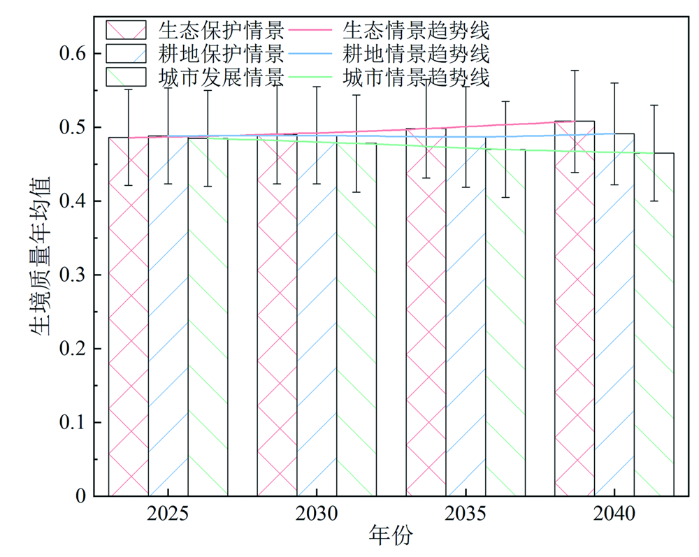
Fig.8 Trends in average annual values of habitat quality under different development scenarios
| [1] | HILLARD E M, NIELSEN C K, GRONINGER J W. Swamp rabbits as indicators of wildlife habitat quality in bottomland hardwood forest ecosystems[J]. Ecological Indicators, 2017, 79: 47-53. |
| [2] |
王同达, 曹锦雪, 赵永华, 等. 基于PSR模型的陕西省土地生态系统健康评价[J]. 应用生态学报, 2021, 32(5): 1563-1572.
DOI |
| [3] | WANG Q, WANG H J. Evaluation for the spatiotemporal patterns of ecological vulnerability and habitat quality: Implications for supporting habitat conservation and healthy sustainable development[J]. Environmental Geochemistry and Health, 2023, 45(5): 2117-2147. |
| [4] | 陶长琪, 陈伟, 郭毅. 新中国成立70年中国工业化进程与经济发展[J]. 数量经济技术经济研究, 2019, 36(8): 3-26. |
| [5] |
张学儒, 周杰, 李梦梅. 基于土地利用格局重建的区域生境质量时空变化分析[J]. 地理学报, 2020, 75(1): 160-178.
DOI |
| [6] |
杨洁, 谢保鹏, 张德罡. 黄河流域生境质量时空演变及其影响因素[J]. 中国沙漠, 2021, 41(4): 12-22.
DOI |
| [7] | 武晶, 刘志民. 生境破碎化对生物多样性的影响研究综述[J]. 生态学杂志, 2014, 33(7): 1946-1952. |
| [8] | 王琼, 卢聪, 韩青, 等. 太子河流域生境质量及其与社会经济的关系[J]. 生态学杂志, 2017, 36(10): 2917-2925. |
| [9] | 王琼, 范志平, 李法云, 等. 蒲河流域河流生境质量综合评价及其与水质响应关系[J]. 生态学杂志, 2015, 34(2): 516-523. |
| [10] | 刘华, 蔡颖, 於梦秋, 等. 太湖流域宜兴片河流生境质量评价[J]. 生态学杂志, 2012, 31(5): 1288-1295. |
| [11] | ZHAO Y, DENG X W, XIANG W H, et al. Predicting potential suitable habitats of Chinese fir under current and future climatic scenarios based on Maxent model[J]. Ecological Informatics, 2021, 64: 101393. |
| [12] | SHERROUSE B C, SEMMENS D J, ANCONA Z H. Social Va-lues for Ecosystem Services (SolVES): Open-source spatial mo-deling of cultural services[J]. Environmental Modelling & Software, 2022, 148: 105259. |
| [13] | SHAN C J, GUO H F, DONG Z C, et al. Study on the river ha-bitat quality in Luanhe based on the eco-hydrodynamic model[J]. Ecological Indicators, 2022, 142: 109262. |
| [14] | ZHENG L, WANG Y, LI J F. Qua.pngying the spatial impact of landscape fragmentation on habitat quality: A multi-temporal dimensional comparison between the Yangtze River Economic Belt and Yellow River Basin of China[J]. Land Use Policy, 2023, 125: 106463. |
| [15] | 朱丽亚, 胡克, 孙爽, 等. 基于InVEST模型的辽宁省海岸带碳储量时空变化研究[J]. 现代地质, 2022, 36(1): 96-104. |
| [16] | WEI Q Q, ABUDUREHEMAN M, HALIKE A, et al. Temporal and spatial variation analysis of habitat quality on the PLUS-InVEST model for Ebinur Lake Basin, China[J]. Ecological Indicators, 2022, 145: 109632. |
| [17] | TONG X Y, XIA G S, LU Q K, et al. Land-cover classification with high-resolution remote sensing images using transferable deep models[J]. Remote Sensing of Environment, 2018, 237:111322. |
| [18] | ZHANG H, ZHANG C, HU T, et al. Exploration of roadway factors and habitat quality using InVEST[J]. Transportation Research Part D: Transport and Environment, 2020, 87: 102551. |
| [19] | TANG F, FU M C, WANG L, et al. Land-use change in Changli County, China: Predicting its spatio-temporal evolution in habitat quality[J]. Ecological Indicators, 2020, 117: 106719. |
| [20] | 李春亮, 王翔, 张炜, 等. 黄土高原西段表层土壤有机碳储量及时空变化规律[J]. 现代地质, 2022, 36(2): 655-661. |
| [21] | 胡丰, 张艳, 郭宇, 等. 基于PLUS和InVEST模型的渭河流域土地利用与生境质量时空变化及预测[J]. 干旱区地理, 2022, 45(4): 1125-1136. |
| [22] | ZHANG P P, LI X, YU Y. Relationship between ecosystem ser-vices and farmers’ well-being in the Yellow River Wetland Nature Reserve of China[J]. Ecological Indicators, 2023, 146:109810. |
| [23] |
孙毅中, 杨静, 宋书颖, 等. 多层次矢量元胞自动机建模及土地利用变化模拟[J]. 地理学报, 2020, 75(10): 2164-2179.
DOI |
| [24] | LIANG X, GUAN Q F, CLARKE K C, et al. Understanding the drivers of sustainable land expansion using a patch-generating land use simulation (PLUS) model: A case study in Wuhan, China[J]. Computers, Environment and Urban Systems, 2021, 85: 101569. |
| [25] | YUAN J L, LIU X H, LI H Y, et al. Assessment of spatial-temporal variations of soil erosion in Hulunbuir Plateau from 2000 to 2050[J]. Land, 2023, 12(6): 1214. |
| [26] | 牛统莉, 熊立华, 陈杰, 等. 基于PLUS模型的长江流域土地利用变化模拟与多情景预测[J]. 武汉大学学报(工学版), 2024, 57(2): 129-141, 151. |
| [27] | 范彦淳. 河南省黄河流域水土保持生态建设成效及做法[J]. 中国水土保持, 2016(10): 24-26. |
| [28] | YANG J, HUANG X. The 30 m annual land cover dataset and its dynamics in China from 1990 to 2019[J]. Earth System Science Data, 2021, 13(8): 3907-3925. |
| [29] | LI S P, LIU J L, LIN J, et al. Spatial and temporal evolution of habitat quality in Fujian Province, China based on the land use change from 1980 to 2018[J]. Journal of Applied Ecology, 2020, 31(12): 4080-4090. |
| [30] |
SONG Y N, WANG M, SUN X F, et al. Quantitative assessment of the habitat quality dynamics in Yellow River Basin, China[J]. Environmental Monitoring and Assessment, 2021, 193(9): 614.
DOI PMID |
| [31] | 吴艳霞, 刘方南, 陈宝童. 黄河流域下游城市群生境质量时空演变及其驱动因素[J]. 水土保持通报, 2023, 43(4): 396-404. |
| [32] |
TERRADO M, SABATER S, CHAPLIN-KRAMER B, et al. Model development for the assessment of terrestrial and aquatic habitat quality in conservation planning[J]. The Science of the Total Environment, 2016, 540: 63-70.
DOI PMID |
| [33] | WANG S Q, ZHENG X Q. Dominant transition probability: Combining CA-Markov model to simulate land use change[J]. Environment, Development and Sustainability, 2023, 25(7): 6829-6847. |
| [34] | YANG Y Y. Evolution of habitat quality and association with land-use changes in mountainous areas: A case study of the Taihang Mountains in Hebei Province, China[J]. Ecological Indicators, 2021, 129: 107967. |
| [35] | GENG W L, LI Y Y, ZHANG P Y, et al. Analyzing spatio-temporal changes and trade-offs/synergies among ecosystem services in the Yellow River Basin, China[J]. Ecological Indicators, 2022, 138: 108825. |
| [36] | ASHRAF M S, AHMAD I, KHAN N M, et al. Streamflow variations in monthly, seasonal, annual and extreme values using Mann-Kendall, spearmen’s rho and innovative trend analysis[J]. Water Resources Management, 2021, 35(1): 243-261. |
| [37] |
王劲峰, 徐成东. 地理探测器: 原理与展望[J]. 地理学报, 2017, 72(1): 116-134.
DOI |
| [38] | WANG J F, LI X H, CHRISTAKOS G, et al. Geographical detectors-based health risk assessment and its application in the neural tube defects study of the Heshun region, China[J]. International Journal of Geographical Information Science, 2010, 24(1): 107-127. |
| [39] | GAO L N, TAO F, LIU R R, et al. Multi-scenario simulation and ecological risk analysis of land use based on the PLUS model: A case study of Nanjing[J]. Sustainable Cities and Society, 2022, 85: 104055. |
| [40] | LI X, FU J Y, JIANG D, et al. Land use optimization in Ningbo City with a coupled GA and PLUS model[J]. Journal of Cleaner Production, 2022, 375: 134004. |
| [41] | 雒舒琪, 胡晓萌, 孙媛, 等. 耦合PLUS-InVEST模型的多情景土地利用变化及其对碳储量影响[J]. 中国生态农业学报, 2023, 31(2): 300-314. |
| [42] | NIE W B, XU B, YANG F, et al. Simulating future land use by coupling ecological security patterns and multiple scenarios[J]. The Science of the Total Environment, 2023, 859: 160262. |
| [43] |
LI M X, ZHANG Z, LIU X P, et al. Multi-scenario analysis of land space based on PLUS and MSPA[J]. Environmental Monitoring and Assessment, 2023, 195(7): 817.
DOI PMID |
| [44] | SUN X Y, JIANG Z, LIU F, et al. Monitoring spatio-temporal dynamics of habitat quality in Nansihu Lake Basin, Eastern China, from 1980 to 2015[J]. Ecological Indicators, 2019, 102: 716-723. |
| [45] | 冯君明, 冯一凡, 李翅, 等. 河势特征分界下的黄河滩区周边城镇生境质量与景观格局演变[J]. 生态学报, 2023, 43(16): 6798-6809. |
| [46] | CHEN X, YU L, CAO Y, et al. Habitat quality dynamics in China’s first group of National Parks in recent four decades: Evidence from land use and land cover changes[J]. Journal of Environmental Management, 2023, 325: 116505. |
| [47] | ZHU C M, ZHANG X L, ZHOU M M, et al. Impacts of urbanization and landscape pattern on habitat quality using OLS and GWR models in Hangzhou, China[J]. Ecological Indicators, 2020, 117: 106654. |
| [48] | OUYANG X, TANG L S, WEI X, et al. Spatial interaction between urbanization and ecosystem services in Chinese urban agglomerations[J]. Land Use Policy, 2021, 109: 105587. |
| [49] | LI J Y, ZHANG C, ZHU S H. Relative contributions of climate and land-use change to ecosystem services in arid inland basins[J]. Journal of Cleaner Production, 2021, 298: 126844. |
| [1] | YAO Ruichen, HAO Shilong, LI Xiuping, HOU Jiacheng, CHEN Haoyuan, ZHANG Yan. Dynamic Evolution of the Vegetation and Its Response to Climate Changes from 1982 to 2020 in the Yellow River Basin (Henan Section) [J]. Geoscience, 2024, 38(03): 612-623. |
| [2] | CHEN Wudi, LIU Xiaohuang, LI Hongyu, LUO Xinping, WANG Ran, XING Liyuan, BAI Yanan, WANG Chao, ZHAO Honghui. Spatiotemporal Changes and Driving Factors of Water Yield Service Based on InVEST Model in Xinjiang from 1990 to 2018 [J]. Geoscience, 2024, 38(03): 636-647. |
| [3] | GUO Jiahui, LIU Xiaohuang, ZHANG Wenbo, YANG Chaolei, WANG Ran, LUO Xinping, XING Liyuan, WANG Chao, ZHAO Honghui. Spatiotemporal Variations of Water Yields in the Yunnan-Guizhou Plateau Based on InVEST and PLUS Models [J]. Geoscience, 2024, 38(03): 624-635. |
| [4] | YUAN Jianglong, LIU Xiaohuang, LI Hongyu, XING Liyuan, LUO Xinping, WANG Ran, WANG Chao, ZHAO Honghui. Spatial and Temporal Variability of Carbon Stocks in Different Land-use Types in the Yiluo River Basin in the Middle Section of the Yellow River from 1990 to 2050 [J]. Geoscience, 2024, 38(03): 559-573. |
| [5] | SHI Chenxia, GAO Yongli, LÜ Guojuan, ZHANG Rui, ZHANG Bingchen. Innovative Ideas on the Utilization of Geological Tourism Resources in Zhengzhou,Henan Province under the Background of High-quality Development of the Yellow River Basin Area [J]. Geoscience, 2024, 38(02): 533-546. |
| [6] | WANG Chongge, LI Junlei, ZHANG Xujiao, YUAN Xiaoning, ZHANG Xiangge, WANG Yifan, WANG Kaiya, LIU Xinlan, RAO Haoshu, LIU Jiang, HOU Engang. Characteristics and Assessment of Geoheritage of the Proposed Hualong National Geopark in Qinghai Province [J]. Geoscience, 2023, 37(02): 512-528. |
| [7] | ZHU Liya, HU Ke, SUN Shuang, LIU Yuhan, LIANG Jiaxin. Research on the Spatiotemporal Variation of Carbon Storage in the Coastal Zone of Liaoning Province Based on InVEST Model [J]. Geoscience, 2022, 36(01): 96-104. |
| Viewed | ||||||
|
Full text |
|
|||||
|
Abstract |
|
|||||