

Geoscience ›› 2017, Vol. 31 ›› Issue (06): 1269-1277.
• Engineering Geology • Previous Articles Next Articles
WU Hang1( ), ZHANG Xujiao1(), QIAO Yansong2, LIANG Ying1, ZHANG Yu1, YANG Shuaibin2
Received:2017-05-15
Revised:2017-09-21
Online:2017-12-10
Published:2017-12-25
CLC Number:
WU Hang, ZHANG Xujiao, QIAO Yansong, LIANG Ying, ZHANG Yu, YANG Shuaibin. Landslide Susceptibility Evaluation Based on Certain Factor and Weight of Evidence: A Case Study in the Longkaikou to Qina Section of Jinshajiang Watershed[J]. Geoscience, 2017, 31(06): 1269-1277.

Fig.1 Regional tectonic map and the distribution of paleo-earthquakes (modified from references of[20-21])

Fig.2 The distribution of elevation in the study area
| 指标 | 原始比例尺(分辨率) | 数据描述 |
|---|---|---|
| 坡度 | 1∶50 000 | 范围为0°~62°,等距划分为10类 |
| 坡向 | 1∶50 000 | 范围为0°~360°,每隔45°划分一类,例如0°~22.5°与337.5°~365°划分为北向斜坡,共计8个方向 |
| 纵剖曲率 | 1∶50 000 | 范围为-3.0~3.8,等距划分为10类 |
| 海拔 | 1∶50 000 | 范围为1 166~3 145 m,等距划分为10类 |
| 岩石性质 | 1∶200 000 | 分类根据《1∶200000岩石性质图》内分类划分,共计30类 |
| NDVI/ m | 30 | 范围为-0.81~0.87,等距划分为10类 |
| 距河流的距离/m | 1.5 | 根据缓冲区分析结果,每隔100 m划分为一类,1 000 m以上单独成类,共计11类 |
| 距道路的距离/m | 1.5 | |
| 距断层的距离/m | 1∶50 000 | 同道路、河流距离分类方式 |
| 第四纪沉积物类型 | 1∶50 000 | 分类根据《1∶50 000第四纪地质图》内分类划分,其中,湖相层、坡积物与冲积相不再细分期次,共计23类 |
Table 1 Subdivisions of the landslide susceptibility evaluation criteria
| 指标 | 原始比例尺(分辨率) | 数据描述 |
|---|---|---|
| 坡度 | 1∶50 000 | 范围为0°~62°,等距划分为10类 |
| 坡向 | 1∶50 000 | 范围为0°~360°,每隔45°划分一类,例如0°~22.5°与337.5°~365°划分为北向斜坡,共计8个方向 |
| 纵剖曲率 | 1∶50 000 | 范围为-3.0~3.8,等距划分为10类 |
| 海拔 | 1∶50 000 | 范围为1 166~3 145 m,等距划分为10类 |
| 岩石性质 | 1∶200 000 | 分类根据《1∶200000岩石性质图》内分类划分,共计30类 |
| NDVI/ m | 30 | 范围为-0.81~0.87,等距划分为10类 |
| 距河流的距离/m | 1.5 | 根据缓冲区分析结果,每隔100 m划分为一类,1 000 m以上单独成类,共计11类 |
| 距道路的距离/m | 1.5 | |
| 距断层的距离/m | 1∶50 000 | 同道路、河流距离分类方式 |
| 第四纪沉积物类型 | 1∶50 000 | 分类根据《1∶50 000第四纪地质图》内分类划分,其中,湖相层、坡积物与冲积相不再细分期次,共计23类 |
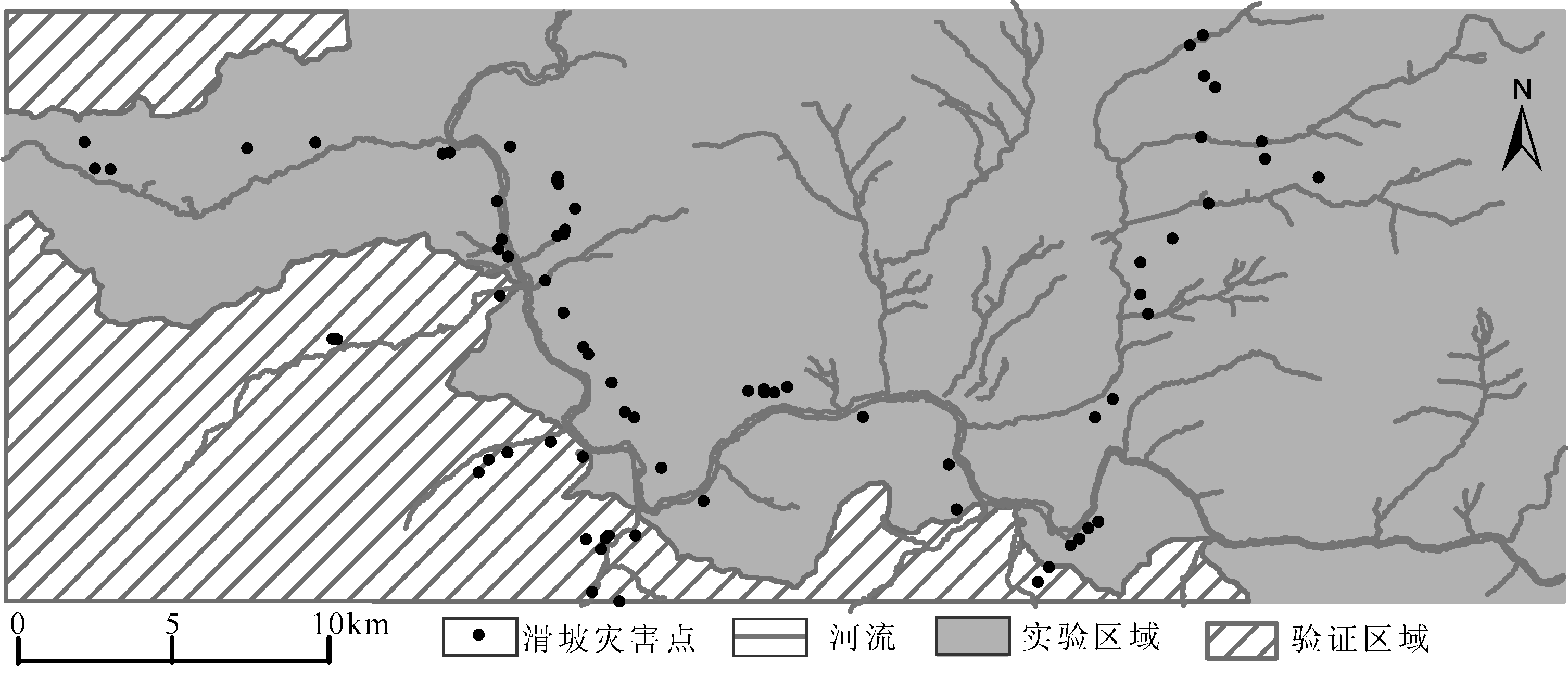
Fig.3 Map showing the experiment area and verification area
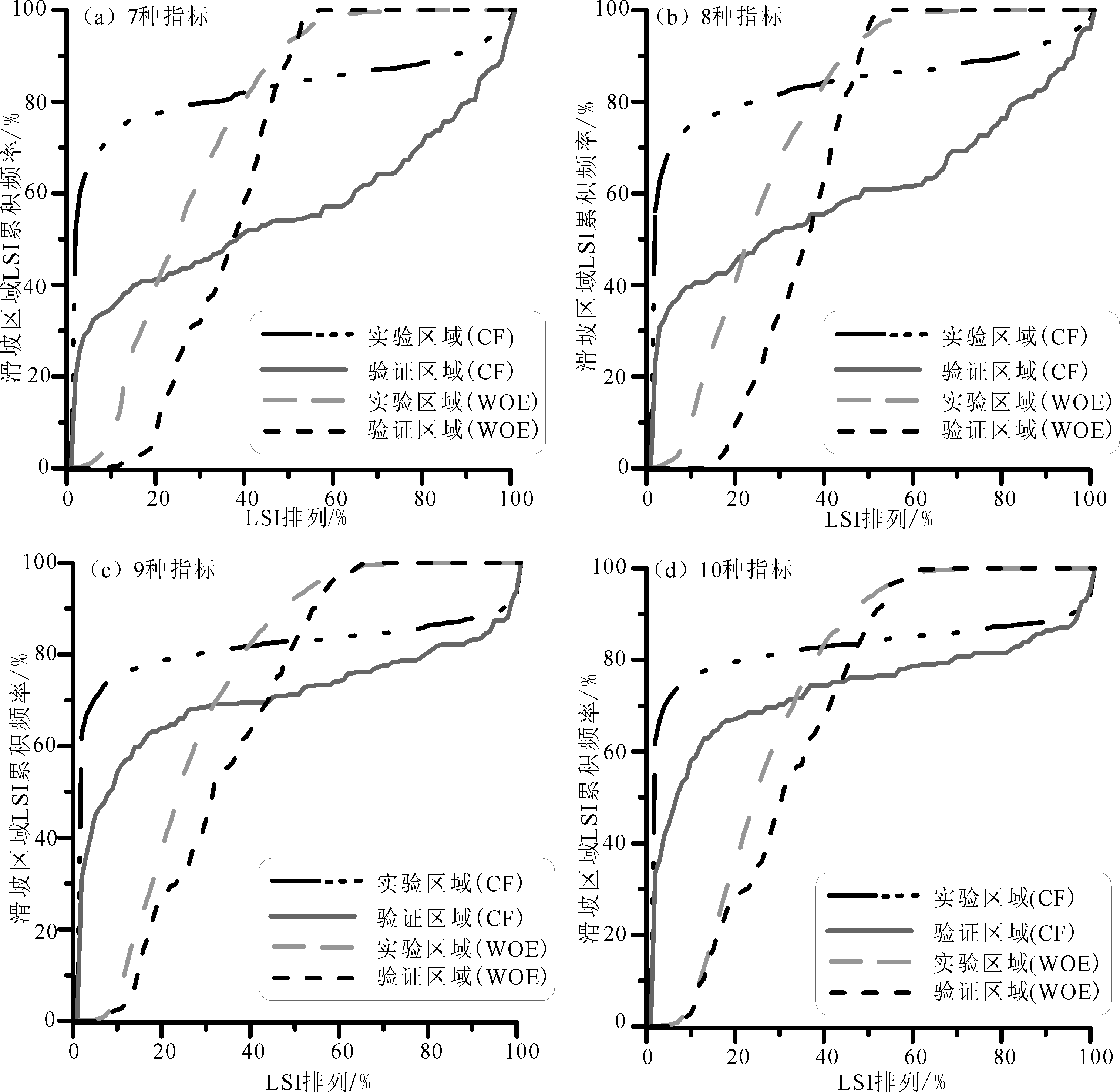
Fig.4 The AUC curves of WOE and CF with combinations of various variables
| 指标(数目) | WOE | CF | |||
|---|---|---|---|---|---|
| 准确率/% | 预测率/% | 准确率/% | 预测率/% | ||
| 坡度、坡向、NDVI、海拔、岩石性质、纵剖面曲率、距河流距离(7) | 74.61 | 65.58 | 83.02 | 56.64 | |
| 坡度、坡向、NDVI、海拔、岩石性质、纵剖面曲率、距道路距离、距河流距离(8) | 76.12 | 66.54 | 84.70 | 61.41 | |
| 坡度、坡向、NDVI、海拔、岩石性质、纵剖面曲率、距河流距离、距断层距离与第四纪沉积物(9) | 74.59 | 67.93 | 82.45 | 71.47 | |
| 坡度、坡向、NDVI、海拔、岩石性质、纵剖面曲率、距道路距离、距河流距离、距断层距离与第四纪沉积物(10) | 74.52 | 69.89 | 83.40 | 74.43 | |
Table 2 The AUC verification results of CF and WOE with combinations of various variables
| 指标(数目) | WOE | CF | |||
|---|---|---|---|---|---|
| 准确率/% | 预测率/% | 准确率/% | 预测率/% | ||
| 坡度、坡向、NDVI、海拔、岩石性质、纵剖面曲率、距河流距离(7) | 74.61 | 65.58 | 83.02 | 56.64 | |
| 坡度、坡向、NDVI、海拔、岩石性质、纵剖面曲率、距道路距离、距河流距离(8) | 76.12 | 66.54 | 84.70 | 61.41 | |
| 坡度、坡向、NDVI、海拔、岩石性质、纵剖面曲率、距河流距离、距断层距离与第四纪沉积物(9) | 74.59 | 67.93 | 82.45 | 71.47 | |
| 坡度、坡向、NDVI、海拔、岩石性质、纵剖面曲率、距道路距离、距河流距离、距断层距离与第四纪沉积物(10) | 74.52 | 69.89 | 83.40 | 74.43 | |

Fig.5 The classification result of landslide susceptibility index

Fig.6 Photographs of geohazards in the study area
| [1] | 张军, 赵芳芳. 滑坡灾害的多源数据分析与评估方法[J]. 地理信息科学, 2008, 10(6):741-748. |
| [2] | 中华人民共和国国土资源部. 2011—2015年中国国土资源公报[R]. 北京: 中华人民共和国国土资源部, 2012—2016. |
| [3] | 吴树仁, 石菊松, 王涛. 突发地质灾害预测评价概论[J]. 地质通报, 2008, 27(11):1753-1763. |
| [4] |
FORMETTA G, RAGO B, CAPPARELLI C, et al. Integrated physically based system for modeling landslide susceptibility[J]. Procedia Earth and Planetary Science, 2014, 9:74-82.
DOI URL |
| [5] | 朱阿兴, 裴韬, 乔建平, 等. 基于专家知识的滑坡危险性模糊评估方法[J]. 地球科学进展, 2006, 25(4):1-12. |
| [6] | 朱良峰, 吴信才, 殷坤龙, 等. 基于GIS的中国滑坡灾害风险分析[J]. 岩土力学, 2003, 24(增刊):221-224. |
| [7] | 许冲, 戴福初, 徐锡伟. 基于 GIS 平台与证据权的地震滑坡易发性评价[J]. 地球科学——中国地质大学学报, 2011, 36(6):1155-1163. |
| [8] | BAUM R L, SAVAGE W Z, GODT J W. TRIGRS—A Fortran program for transient rainfall infiltration and grid-based regional slope-stability analysis,version 2.0[R]. Reston: US Geological Survey, 2008. |
| [9] |
BǍLTEANU D, CHENDES C, SIMA M, et al. A country-wide spatial assessment of landslide susceptibility in Romania[J]. Geomorphology, 2010, 124: 102-112.
DOI URL |
| [10] |
GUO C, MONTGOMERY D R, ZHANG Y, et al. Quantitative assessment of landslide susceptibility along the Xianshuihe fault zone, Tibetan Plateau, China[J]. Geomorphology, 2015, 248: 93-110.
DOI URL |
| [11] |
HONG H, PRADHAN B, XUA C, et al. Spatial prediction of landslide hazard at the Yihuang area (China) using two-class kernel logistic regression, alternating decision tree and support vector machines[J]. Catena, 2015, 133:266-281.
DOI URL |
| [12] | 唐川. 金沙江流域 (云南境内) 山地灾害危险性评价[J]. 山地学报, 2004, 22(4): 451-460. |
| [13] | 黎艳, 陈剑, 许冲, 等. 基于 AHP 的半干旱区泥石流易发性评价: 以金沙江上游奔子栏—昌波河段为例[J]. 现代地质, 2015, 29(4):975-982. |
| [14] | 崔杰, 王兰生, 徐进, 等. 金沙江中游滑坡堵江事件及古滑坡体稳定性分析[J]. 工程地质学报, 2008, 16(1): 6-10. |
| [15] | 张晨, 王清, 陈剑平, 等. 金沙江流域泥石流的组合赋权法危险度评价[J]. 岩土力学, 2011, 32(3): 831-836. |
| [16] | 罗睿洁, 吴中海, 黄小龙, 等. 滇西北宾川地区主要活动断裂及其活动构造体系[J]. 地质通报, 2015, 34(1):155-170. |
| [17] | 吴中海, 赵根模, 龙长兴, 等. 青藏高原东南缘现今大震活动特征及其趋势: 活动构造体系角度的初步分析结果[J]. 地质学报, 2014, 88(8):1401-1416. |
| [18] | 唐渊, 刘俊来. 川滇西部上新世以来构造地貌: 断裂控制的盆地发育及对于远程陆内构造过程的约束[J]. 岩石学报, 2010, 26(6): 1925-1937. |
| [19] | 吴根耀. 滇西北丽江—大理地区第四纪断裂活动的方式, 机制及其对环境的影响[J]. 第四纪研究, 1992, 12(3): 265-276. |
| [20] | 黄小巾, 吴中海, 李家存, 等. 滇西北裂陷带的构造地貌特征与第四纪构造活动性[J]. 地质通报, 2014, 33(4):578-593. |
| [21] | MOHADJER S, EHLERS T A, BENDICK R, et al. A Quaternary fault database for central Asia[J]. Natural Hazards and Earth System Sciences, 2016, 16(2):529-542. |
| [22] | 张方伟, 李春龙, 訾丽. 金沙江流域降水特征分析[J]. 人民长江, 2011, 42(6):94-97. |
| [23] | 兰恒星, 王苓涓, 周成虎. 云南小江流域滑坡关键影响因子研究[J]. 中国地质灾害与防治学报, 2003, 14(1):100-106. |
| [24] |
HASEKIOĜULLARI G D, ERCANOGLU M. A new approach to use AHP in landslide susceptibility mapping: a case study at Yenice (Karabuk, NW Turkey)[J]. Natural Hazards, 2012, 63(2): 1157-1179.
DOI URL |
| [25] |
UPDIKE R G, EGAN J A, MORIWAKI Y, et al. A model for earthquake-induced translatory landslides in Quaternary sediments.[J]. Geological Society of America Bulletin, 1988, 100(5): 783-792.
DOI URL |
| [26] |
HUETE A, DIDAN K, MIURA T, et al. Overview of the radiometric and biophysical performance of the MODIS vegetation indices[J]. Remote Sensing of Environment, 2002, 83(1): 195-213.
DOI URL |
| [27] |
GUZZETTI F, REICHENBACH P, CARDINALI M, et al. Probabilistic landslide hazard assessment at the basin scale[J]. Geomorphology, 2005, 72:272-299.
DOI URL |
| [28] |
PARK S, CHOI C, KIM B, et al. Landslide susceptibility mapping using frequency ratio, analytic hierarchy process, logistic regression, and artificial neural network methods at the Inje area, Korea[J]. Environmental Earth Sciences, 2013, 68(5):1443-1464.
DOI URL |
| [29] |
CHEN W, LI W, CHAI H, et al. GIS-based landslide susceptibility mapping using analytical hierarchy process (AHP) and certainty factor (CF) models for the Baozhong region of Baoji City, China[J]. Environmental Earth Sciences, 2016, 75(1):1-14.
DOI URL |
| [30] | BONHAM-CARTER G F, AGTERBERG F P. Weights of evidence:a new approach to mapping mineral potential[M]// DAVISJ C, HERZFELDU C. Statistical Applications in the Earth Sciences. Vancouver: Geological Survey of Canada, 1990: 231-245. |
| [31] |
DAHAL R K, HASEGAWA S, NONOMURA A, et al. GIS-based weights-of-evidence modelling of rainfall-induced landslides in small catchments for landslide susceptibility mapping[J]. Environmental Geology, 2008, 54(2): 311-324.
DOI URL |
| [32] |
SHORTLIFFE E H, BUCHANAN B G. A model of inexact reasoning in medicine[J]. Mathematical Biosciences, 1975, 23(3): 351-379.
DOI URL |
| [33] | HECKERMAN D. Probabilistic interpretation of MYCIN’s certainty factors[J]. Machine Intelligence & Pattern Recognition, 1986, 4: 167-196. |
| [34] |
GUZZETTI F, MONDINI A, CARDINALI M, et al. Landslide inventory maps: New tools for an old problem[J]. Earth-Science Reviews, 2012, 112: 42-66.
DOI URL |
| [35] |
YILMAZ I. Landslide susceptibility mapping using frequency rat-io,logistic regression, artificial neural networks and their comparison: a case study from Kat landslides (Tokat-Turkey)[J]. Computers & Geosciences, 2009, 35(6): 1125-1138.
DOI URL |
| [36] | 韩淑琴, 陈情来, 张永双, 等. 滇西北周城—清水断裂带晚新生代活动性初步研究[J]. 现代地质, 2007, 21(3):498-504. |
| Viewed | ||||||
|
Full text |
|
|||||
|
Abstract |
|
|||||