

现代地质 ›› 2017, Vol. 31 ›› Issue (02): 421-432.
• 环境地质学 • 上一篇
黄健民( ), 郑小战(), 胡让全, 陈建新, 吕镁娜, 陈小月, 郭宇, 刁群
收稿日期:2015-12-22
修回日期:2017-01-04
出版日期:2017-04-10
发布日期:2017-04-25
通讯作者:
郑小战,男,高级工程师,1968年出生,地质工程专业,主要从事水工环地质研究工作。Email:作者简介:黄健民,男,高级工程师,1966年出生,地质工程专业,从事地质环境保护与地质灾害防治工作。Email:gzhjma@163.com。
基金资助:
HUANG Jianmin(), ZHENG Xiaozhan(), HU Rangquan, CHEN Jianxin, LÜ Meina, CHEN Xiaoyue, GUO Yu, DIAO Qun
Received:2015-12-22
Revised:2017-01-04
Online:2017-04-10
Published:2017-04-25
摘要:
受武广客运专线金沙洲隧道施工抽排大量地下水的影响, 2007—2012年广州金沙洲发生了大规模岩溶地面塌陷、地面沉降地质灾害,造成了重大经济损失。为防治地质灾害,采用综合地质调查、地下水位监测、地面沉降监测、物探、钻探和试验等手段勘查和研究,建立了完善的地下水位和地面沉降监测网络。在此基础上,根据地质环境条件、岩溶发育程度和地质灾害分布特征进行岩溶塌陷易发性分区,选择地下水位变化量和地面沉降量这两个与岩溶塌陷最直接、最敏感和最重要的参数,从预警预报参数选择、时间尺度选取、判据分析计算、预警预报方法、模型系统的建立等方面进行研究,选取临界日综合地下水位变化量和临界日综合地面沉降量作为预警预报判据,结合三维地质结构模型建立岩溶塌陷预警预报模型系统。成功地预警预报了两起岩溶地面塌陷,取得较好的预报效果,说明该岩溶地面塌陷预警预报模型系统实用、有效,为金沙洲防灾减灾提供地质科学依据,为当地的社会稳定和经济可持续发展提供技术支撑。
中图分类号:
黄健民, 郑小战, 胡让全, 陈建新, 吕镁娜, 陈小月, 郭宇, 刁群. 广州金沙洲岩溶地面塌陷灾害预警预报研究[J]. 现代地质, 2017, 31(02): 421-432.
HUANG Jianmin, ZHENG Xiaozhan, HU Rangquan, CHEN Jianxin, LÜ Meina, CHEN Xiaoyue, GUO Yu, DIAO Qun. A Study of Warning and Forecasting of Karst Collapse Geological Disaster in Jinshazhou of Guangzhou[J]. Geoscience, 2017, 31(02): 421-432.

图1 广州金沙洲地质灾害分布图 1.白垩系大塱山组砂岩;2.石炭系壶天群灰岩;3.石炭系测水组砂页岩;4.石炭系石磴子组灰岩;5.石炭系大赛坝组砂岩;6.侏罗系正长斑岩;7.不整合界线;8.隐伏地质界线;9.实测断裂及编号;10.推测断裂及编号;11.地质剖面线及编号;12.基坑(抽水)点;13.孔号/水位标高(m);14.地面塌陷及编号;15.地面沉降及编号;16.地面沉降范围
Fig.1 Map showing geological hazard distribution in Jinshazhou of Guangzhou

图2 金沙洲C-D地质剖面图 1.白垩系大塱山组砂岩;2.石炭系壶天群灰岩;3.石炭系测水组砂页岩;4.石炭系石磴子组灰岩;5.石炭系大赛坝组砂岩;6.推测断裂及编号;7.构造角砾岩;8.孔号/孔口标高(m);9.地质剖面线及编号;10.回填土;11.黏土;12.淤泥;13.泥岩;14.碳质泥岩;15.细砂;16.粉砂质泥岩;17.砂岩;18.泥质粉砂岩;19.灰岩;20.页岩
Fig.2 C-D geological profile in Jinshazhou

图3 金沙洲水文地质简图 1.白垩系大塱山组砂岩;2.石炭系壶天群灰岩;3.石炭系测水组砂页岩;4.石炭系石磴子组灰岩;5.石炭系大赛坝组砂岩;6.侏罗系正长斑岩;7.不整合界线;8.隐伏地质界线;9.实测断裂及编号;10.推测断裂及编号;11.地质剖面线及编号;12.基坑(抽水点);13.孔号/水位标高(m);14.孔号/水位标高(m)和涌水量(m3/d);15.含水层界线;16.基岩水水位等值线及标高(m);17.基岩水流向;18.水量贫乏层状基岩裂隙水;19.上部松散岩类孔隙水;下部碳酸盐岩类裂隙溶洞水
Fig.3 Sketch map of hydrogeology in Jinshazhou

图4 金沙洲地质灾害易发程度分区评价图(图例同前) Ⅰ.地面塌陷高易发区;Ⅱ.地面塌陷中易发区;Ⅲ.地面塌陷低易发区;Ⅳ.地面塌陷不易发区
Fig.4 Map showing susceptible degree evaluation of geological disaster in Jinshazhou
| 预报时间尺度 | 时间界限 | 预报对象 | 预警预报内容 |
|---|---|---|---|
| 长期预报(背景预测) | 大于1年 | 区域性或岩溶塌陷重点地段 | 长期趋势预报、稳定性评价及危险性预报 |
| 中期预报(防灾预报) | 1月至1年 | 岩溶塌陷重点地段 | 险情预报、危害程度预测及灾情预评估 |
| 短期预报(险情预报) | 3天至1月 | 地面有明显沉降或裂缝扩大现象的地段 | 短期灾情预报,对短期变形活动趋势作出预测 |
| 临灾预警 | 1~3天 | 地面有显著突变前兆特征的地段 | 岩溶塌陷特定地段预警预报 |
表1 岩溶塌陷预警预报时间尺度划分
Table 1 Time scale classification of early warning and forecasting of karst collapse
| 预报时间尺度 | 时间界限 | 预报对象 | 预警预报内容 |
|---|---|---|---|
| 长期预报(背景预测) | 大于1年 | 区域性或岩溶塌陷重点地段 | 长期趋势预报、稳定性评价及危险性预报 |
| 中期预报(防灾预报) | 1月至1年 | 岩溶塌陷重点地段 | 险情预报、危害程度预测及灾情预评估 |
| 短期预报(险情预报) | 3天至1月 | 地面有明显沉降或裂缝扩大现象的地段 | 短期灾情预报,对短期变形活动趋势作出预测 |
| 临灾预警 | 1~3天 | 地面有显著突变前兆特征的地段 | 岩溶塌陷特定地段预警预报 |
| 预报时间尺度 | 预报参数 | |
|---|---|---|
| 中长期预测 | 降雨量及降雨强度、地质环境背景、地球物理及间接等参数 | |
| 短期预报 | 降雨量及降雨强度、人类工程活动强度、地下水位变幅值、地面沉降量、裂缝位移及裂缝扩张速率等参数 | |
| 临灾预警 | 地下水位变幅值、地表沉降速率、裂缝位移、孔隙水压力和地面建筑物变形等参数 | |
表2 岩溶塌陷预警预报时间尺度与预报参数对照
Table 2 Check list of time scale and forecasting parameters for early warning and forecasting of karst collapse
| 预报时间尺度 | 预报参数 | |
|---|---|---|
| 中长期预测 | 降雨量及降雨强度、地质环境背景、地球物理及间接等参数 | |
| 短期预报 | 降雨量及降雨强度、人类工程活动强度、地下水位变幅值、地面沉降量、裂缝位移及裂缝扩张速率等参数 | |
| 临灾预警 | 地下水位变幅值、地表沉降速率、裂缝位移、孔隙水压力和地面建筑物变形等参数 | |
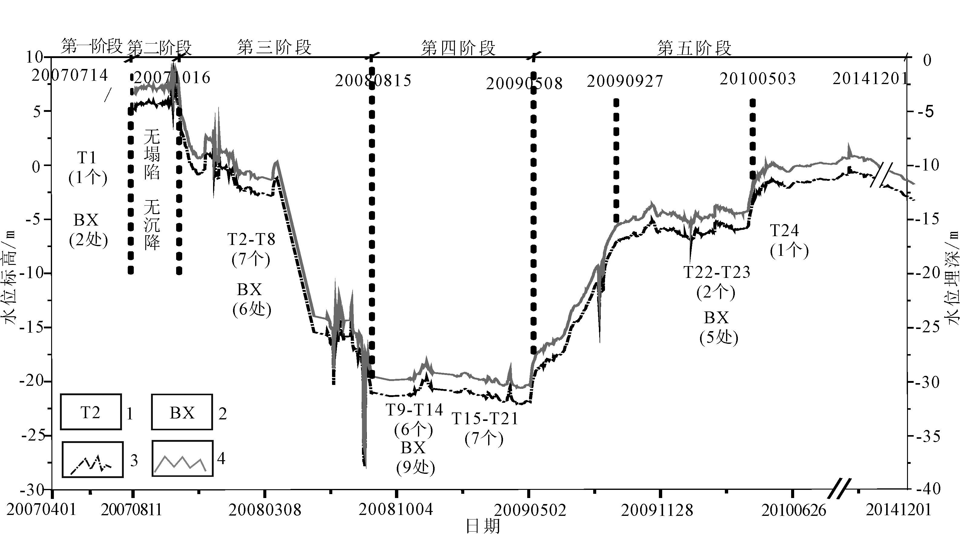
图5 K40监测点岩溶塌陷、地面沉降与金沙洲隧道施工不同阶段地下水位变化关系图 1.地面塌陷编号;2.地面沉降编号;3.水位标高;4.水位埋深
Fig.5 Relationship among karst collapse, ground subsidence and groundwater level change at K40 in different stages during Jinshazhou tunnel construction
| 阶段 | 时间 | 人类工程活动 抽排地下水 | 地下水动态变化情况 (以K40监测点为例) | 发生岩溶塌陷、 地面沉降情况 | 备注 |
|---|---|---|---|---|---|
| 第一 阶段 | 200608012— 20070714 | 2007年3月1日1#竖井施工,抽排地下水量约1 200 m3/d | 由初始水位埋深4.0 m急速下降至40 m | 2007年7月14日发生1个塌陷(T1),发生2处地面沉降(BX1-7、BX1-10) | 1#竖井(盾构井)深为40 m |
| 第二 阶段 | 20070715— 20071019 | 20070823—20071018 1#竖井停止施工、停止抽排地下水,进行截水帷幕注浆 | 水位逐步回升,恢复至初始状态,并保持相对稳定 | 未发生岩溶塌陷、地面沉降 | |
| 第三 阶段 | 20071020— 20080815 | 1#竖井复工,边注浆止水边施工。抽排地下水量约为2 300m3/d | 由恢复回来的水位埋深4.0 m再次急剧下降至27.43 m | 发生7个岩溶塌陷(T2—T8),发生6处地面沉降(BX1-1—BX1-4、BX1-8—BX1-9) | 监测结果显示:地下水位形成以K40为中心降落漏斗,影响范围扩大 |
| 第四 阶段 | 20080816— 20090507 | 隧道全面施工,抽排地下水量2 000~3 500 m3/d | 水位埋深由27.43 m继续下降至30.58 m | 发生6个岩溶塌陷(T9—T14),发生9处地面沉降(BX1-5、BX2-1—BX2-3、BX3-1、BX4-1—BX4-3、BX5-1) | 地下水位持续下降,降落漏斗影响范围继续扩大,降落漏斗影响范围约1 000 m |
| 第五 阶段 | 20090508— 20100503 | 隧道完工,仍在抽排地下水,抽排水量约1 000 m3/d左右 | 水位埋深由30.58 m逐渐回升至10.97 m | 发生9个岩溶塌陷(T15—T23)、5处地面沉降(BX2-1—BX2-3、BX3-1、BX4-1地面沉降继续); | 由于隧道完工后仍在抽排地下水,地下水位无法恢复到初始状态。监测到ZK9008地下水位波动异常,并发出了预警预报 |
| 20100504— 20141230 | 2012年5月14日发生1个塌陷(T24),到目前为止,这是最后一个塌陷。地面沉降逐渐减缓 |
表3 岩溶塌陷、地面沉降与金沙洲隧道施工不同阶段地下水位变化关系统计表
Table 3 Statistics of relationship among groundwater dynamic change, karst collapse and ground subsidence at different stages during Jinshazhou tunnel construction
| 阶段 | 时间 | 人类工程活动 抽排地下水 | 地下水动态变化情况 (以K40监测点为例) | 发生岩溶塌陷、 地面沉降情况 | 备注 |
|---|---|---|---|---|---|
| 第一 阶段 | 200608012— 20070714 | 2007年3月1日1#竖井施工,抽排地下水量约1 200 m3/d | 由初始水位埋深4.0 m急速下降至40 m | 2007年7月14日发生1个塌陷(T1),发生2处地面沉降(BX1-7、BX1-10) | 1#竖井(盾构井)深为40 m |
| 第二 阶段 | 20070715— 20071019 | 20070823—20071018 1#竖井停止施工、停止抽排地下水,进行截水帷幕注浆 | 水位逐步回升,恢复至初始状态,并保持相对稳定 | 未发生岩溶塌陷、地面沉降 | |
| 第三 阶段 | 20071020— 20080815 | 1#竖井复工,边注浆止水边施工。抽排地下水量约为2 300m3/d | 由恢复回来的水位埋深4.0 m再次急剧下降至27.43 m | 发生7个岩溶塌陷(T2—T8),发生6处地面沉降(BX1-1—BX1-4、BX1-8—BX1-9) | 监测结果显示:地下水位形成以K40为中心降落漏斗,影响范围扩大 |
| 第四 阶段 | 20080816— 20090507 | 隧道全面施工,抽排地下水量2 000~3 500 m3/d | 水位埋深由27.43 m继续下降至30.58 m | 发生6个岩溶塌陷(T9—T14),发生9处地面沉降(BX1-5、BX2-1—BX2-3、BX3-1、BX4-1—BX4-3、BX5-1) | 地下水位持续下降,降落漏斗影响范围继续扩大,降落漏斗影响范围约1 000 m |
| 第五 阶段 | 20090508— 20100503 | 隧道完工,仍在抽排地下水,抽排水量约1 000 m3/d左右 | 水位埋深由30.58 m逐渐回升至10.97 m | 发生9个岩溶塌陷(T15—T23)、5处地面沉降(BX2-1—BX2-3、BX3-1、BX4-1地面沉降继续); | 由于隧道完工后仍在抽排地下水,地下水位无法恢复到初始状态。监测到ZK9008地下水位波动异常,并发出了预警预报 |
| 20100504— 20141230 | 2012年5月14日发生1个塌陷(T24),到目前为止,这是最后一个塌陷。地面沉降逐渐减缓 |
| 岩溶塌陷 活动频率 | 临界日综合地下水位变化量Pa临/m | ||||
|---|---|---|---|---|---|
| 1天均值 | 2天均值 | 3天均值 | 4天均值 | 5天均值 | |
| 0.1 | 0.25 | 0.22 | 0.18 | 0.17 | 0.15 |
| 0.2 | 0.57 | 0.53 | 0.45 | 0.43 | 0.41 |
| 0.3 | 0.65 | 0.61 | 0.56 | 0.52 | 0.46 |
| 0.4 | 0.73 | 0.65 | 0.59 | 0.53 | 0.49 |
| 0.5 | 0.78 | 0.72 | 0.63 | 0.55 | 0.51 |
| 0.6 | 1.52 | 1.48 | 1.37 | 1.35 | 1.26 |
| 0.7 | 2.15 | 2.07 | 1.95 | 1.92 | 1.83 |
| 0.8 | 3.52 | 3.42 | 3.25 | 3.21 | 3.01 |
| 0.9 | 4.23 | 4.15 | 3.88 | 3.62 | 3.57 |
表4 金沙洲岩溶塌陷频率与临界日综合地下水位变化量关系统计
Table 4 Statistics of relationship between karst collapse frequency and comprehensive underground water level variation in critical days in Jinshazhou
| 岩溶塌陷 活动频率 | 临界日综合地下水位变化量Pa临/m | ||||
|---|---|---|---|---|---|
| 1天均值 | 2天均值 | 3天均值 | 4天均值 | 5天均值 | |
| 0.1 | 0.25 | 0.22 | 0.18 | 0.17 | 0.15 |
| 0.2 | 0.57 | 0.53 | 0.45 | 0.43 | 0.41 |
| 0.3 | 0.65 | 0.61 | 0.56 | 0.52 | 0.46 |
| 0.4 | 0.73 | 0.65 | 0.59 | 0.53 | 0.49 |
| 0.5 | 0.78 | 0.72 | 0.63 | 0.55 | 0.51 |
| 0.6 | 1.52 | 1.48 | 1.37 | 1.35 | 1.26 |
| 0.7 | 2.15 | 2.07 | 1.95 | 1.92 | 1.83 |
| 0.8 | 3.52 | 3.42 | 3.25 | 3.21 | 3.01 |
| 0.9 | 4.23 | 4.15 | 3.88 | 3.62 | 3.57 |
| 岩溶塌陷 活动频率 | 临界日综合地面沉降量Pb临/mm | ||||
|---|---|---|---|---|---|
| 1天均值 | 2天均值 | 3天均值 | 4天均值 | 5天均值 | |
| 0.1 | 0.058 | 0.051 | 0.048 | 0.045 | 0.039 |
| 0.2 | 0.069 | 0.065 | 0.061 | 0.056 | 0.048 |
| 0.3 | 0.073 | 0.068 | 0.065 | 0.059 | 0.051 |
| 0.4 | 0.079 | 0.069 | 0.067 | 0.066 | 0.056 |
| 0.5 | 0.083 | 0.072 | 0.071 | 0.068 | 0.062 |
| 0.6 | 0.098 | 0.087 | 0.079 | 0.082 | 0.078 |
| 0.7 | 1.256 | 1.025 | 0.098 | 0.095 | 0.092 |
| 0.8 | 2.787 | 2.563 | 1.878 | 1.652 | 1.028 |
| 0.9 | 3.211 | 3.102 | 2.576 | 2.127 | 1.876 |
表5 金沙洲岩溶塌陷频率与临界日综合地面沉降量关系统计
Table 5 Statistics of relationship between karst collapse frequency and comprehensive ground settlement in critical days in Jinshazhou
| 岩溶塌陷 活动频率 | 临界日综合地面沉降量Pb临/mm | ||||
|---|---|---|---|---|---|
| 1天均值 | 2天均值 | 3天均值 | 4天均值 | 5天均值 | |
| 0.1 | 0.058 | 0.051 | 0.048 | 0.045 | 0.039 |
| 0.2 | 0.069 | 0.065 | 0.061 | 0.056 | 0.048 |
| 0.3 | 0.073 | 0.068 | 0.065 | 0.059 | 0.051 |
| 0.4 | 0.079 | 0.069 | 0.067 | 0.066 | 0.056 |
| 0.5 | 0.083 | 0.072 | 0.071 | 0.068 | 0.062 |
| 0.6 | 0.098 | 0.087 | 0.079 | 0.082 | 0.078 |
| 0.7 | 1.256 | 1.025 | 0.098 | 0.095 | 0.092 |
| 0.8 | 2.787 | 2.563 | 1.878 | 1.652 | 1.028 |
| 0.9 | 3.211 | 3.102 | 2.576 | 2.127 | 1.876 |
| 级 别 | 预警预 报等级 | 发生岩溶 塌陷的可 能性 | 综合地下 水位变化 范围 | 综合地面 沉降量变 化范围 | 预警预报 时间段 | |||
|---|---|---|---|---|---|---|---|---|
| 1 | 很小 | 一个月短期预报 | ||||||
| 2 | 较小 | |||||||
| 3 | 预报级(启动 值或注意级) | 较大 | [Pa预, Pa临) | [Pb预, Pb临) | 三天 短时 预报 | |||
| 4 | 临报级(加速 值或预警级) | 大 | [Pa临, Pa警) | [Pb临, Pb警) | 一天 短时 预警 | |||
| 5 | 警报级(临灾 值或警报级) | 很大 | [Pa警≤ PC) | [Pb警≤ PC) | ||||
表6 岩溶塌陷预警预报分级表
Table 6 Classification of early warning and forecasting of karst collapse
| 级 别 | 预警预 报等级 | 发生岩溶 塌陷的可 能性 | 综合地下 水位变化 范围 | 综合地面 沉降量变 化范围 | 预警预报 时间段 | |||
|---|---|---|---|---|---|---|---|---|
| 1 | 很小 | 一个月短期预报 | ||||||
| 2 | 较小 | |||||||
| 3 | 预报级(启动 值或注意级) | 较大 | [Pa预, Pa临) | [Pb预, Pb临) | 三天 短时 预报 | |||
| 4 | 临报级(加速 值或预警级) | 大 | [Pa临, Pa警) | [Pb临, Pb警) | 一天 短时 预警 | |||
| 5 | 警报级(临灾 值或警报级) | 很大 | [Pa警≤ PC) | [Pb警≤ PC) | ||||
| 岩溶塌陷灾害分级 | 1天临界日综合量 | 2天临界日综合量 | 3天临界日综合量 | |||||
|---|---|---|---|---|---|---|---|---|
| 地下水位变幅 /m | 地面沉降量 /mm | 地下水位变幅 /m | 地面沉降量 /mm | 地下水位变幅 /m | 地面沉降量 /mm | |||
| 预报级(可能性较大)(启动值) | 0.525 | 0.065 | 0.486 | 0.059 | 0.357 | 0.053 | ||
| 临报级(可能性大)(加速值) | 0.653 | 0.073 | 0.615 | 0.068 | 0.568 | 0.065 | ||
| 警报级(可能性很大)(临灾值) | 0.783 | 0.083 | 0.727 | 0.072 | 0.639 | 0.071 | ||
表7 金沙洲岩溶塌陷预警预报分级阈值
Table 7 Classification threshold value of early warning and forecasting of karst collapse in Jinshazhou
| 岩溶塌陷灾害分级 | 1天临界日综合量 | 2天临界日综合量 | 3天临界日综合量 | |||||
|---|---|---|---|---|---|---|---|---|
| 地下水位变幅 /m | 地面沉降量 /mm | 地下水位变幅 /m | 地面沉降量 /mm | 地下水位变幅 /m | 地面沉降量 /mm | |||
| 预报级(可能性较大)(启动值) | 0.525 | 0.065 | 0.486 | 0.059 | 0.357 | 0.053 | ||
| 临报级(可能性大)(加速值) | 0.653 | 0.073 | 0.615 | 0.068 | 0.568 | 0.065 | ||
| 警报级(可能性很大)(临灾值) | 0.783 | 0.083 | 0.727 | 0.072 | 0.639 | 0.071 | ||

图6 金沙洲岩溶塌陷预警预报系统构成
Fig.6 Framework of early warning and forecasting system of karst collapse in Jinshazhou
| [1] | BENSON Richard C. Assessment and long term monitoring of localized subsidence using ground penetrating radar[M]//BECK B F,WILSON W L.Proceedings of the 2nd Multidisciplinary Conference on Sinkholes and the Environmental Impacts of Karst. Orlando: A A Balkema Publishers, 1987:161-170. |
| [2] | ZHANG X F, HAO W J, ZHANG Q, et al. Development of optical fiber strain monitoring system based on BOTDR[M]//CUI J P, ZHANG Y,WU J.Proceedings of 10th International Conference on Electronic Measurement & Instruments. Washington: IEEE PRESS, 2011:38-41. |
| [3] | VARNUM Nick C. Geographical information systems to assess natural hazards in the east central Sierrs Nevada[J]. Journal of Imaging Technology, 1991, 17:57-61. |
| [4] | 金爱善. 采用神经网络模型对天津滨海新区地面沉降预测的研究[J]. 现代地质, 2000, 14(4):475-478. |
| [5] | 胡志瑞. 基于WebGIS的地质灾害预警预报系统研究[J]. 测绘与空间地理信息, 2012, 35(11):56-59. |
| [6] | 冯克印, 郑庭明, 董强, 等. 基于水动力场控制的岩溶塌陷预警预报研究[J]. 工程勘察, 2006(10):29-31. |
| [7] | 冯克印, 任翠爱, 姚春梅, 等. 地下水数值模拟在岩溶塌陷预警系统中的应用——以山东临沂市城区岩溶塌陷为例[J]. 中国地质灾害与防治学报, 2007, 18(2):112-116. |
| [8] | 蒙彦, 黄健民, 雷明堂, 等. 基于灰色Verhulst 模型的岩溶塌陷定量预报预测方法[J]. 中国岩溶, 2009, 28(1):17-22. |
| [9] | 王滨, 李治广, 董昕, 等. 岩溶塌陷的致塌力学模型研究——以泰安市东羊娄岩溶塌陷为例[J]. 自然灾害学报, 2011, 20(4):119-125. |
| [10] | 雷明堂, 蒋小珍, 李瑜. 岩溶塌陷模型试验——以武昌为例[J]. 地质灾害与环境保护, 1993, 4(2): 39-44. |
| [11] | 王建秀, 杨立中, 刘丹. 覆盖型岩溶区土体塌陷典型数学模型的研究[J]. 中国地质灾害与防治学报, 1998, 9(3):54-59. |
| [12] | 黄健民, 吕镁娜, 郭宇, 等. 广州市金沙洲岩溶塌陷地质灾害成因分析[J]. 中国岩溶, 2013, 32(2):167-174. |
| [13] | 黄健民, 邓雄文, 胡让全. 广州金沙洲岩溶区地下水位变化与地面塌陷及地面沉降关系探讨[J]. 中国地质, 2015, 42(1):300-307. |
| [14] | 唐攀, 吴仕强, 于炳松, 等. 古岩溶塌陷的成因特点与研究手段[J]. 现代地质, 2015, 29(3):675-683. |
| [15] | 郑小战, 黄健民, 李德洲. 广花盆地南部金沙洲岩溶演变及环境特征[J]. 水文地质工程地质, 2014, 41(1):138-143. |
| [16] | 张婉婷, 漆继红, 许模. 西南地区隧道工程条件下岩溶地下水系统变化特征分析[J]. 现代地质, 2015, 29(2):421-427. |
| [17] | 陈小月, 黄健民, 卢薇. 基于FEFLOW的广州金沙洲地区地下水流场数值模拟研究[J]. 地下水, 2014, 36(4):4-9. |
| [18] | 郭宇, 黄健民, 陈建新, 等. 广州市白云区金沙洲地区地质灾害风险区划[J]. 热带地理, 2013(6):659-665. |
| [19] | 张书余. 地质灾害气象预报基础[M]. 北京: 气象出版社, 2005:140-143. |
| [1] | 王瑞丰, 翟延亮, 张宝君, 申国强, 曾一凡. 基于GIS与AHP耦合技术的承德地区地质灾害危害性评价[J]. 现代地质, 2023, 37(04): 1023-1032. |
| [2] | 李信, 薛桂澄, 夏南, 柳长柱, 杨永鹏, 马波. 基于CF、CF-LR和CF-AHP模型的国家热带雨林公园地质灾害易发性研究:以海南保亭为例[J]. 现代地质, 2023, 37(04): 1033-1043. |
| [3] | 郭长宝, 吴瑞安, 蒋良文, 钟宁, 王炀, 王栋, 张永双, 杨志华, 孟文, 李雪, 刘贵. 川藏铁路雅安—林芝段典型地质灾害与工程地质问题[J]. 现代地质, 2021, 35(01): 1-17. |
| [4] | 张绪财, 金晓媚, 朱晓倩, 张京. 格尔木河流域植被指数时空分布及其影响因素研究[J]. 现代地质, 2019, 33(02): 461-468. |
| [5] | 张晓东, 刘湘南, 赵志鹏, 吴文忠, 刘海燕, 张勇, 高宇亮. 信息量模型、确定性系数模型与逻辑回归模型组合评价地质灾害敏感性的对比研究[J]. 现代地质, 2018, 32(03): 602-610. |
| [6] | 吴瑞安, 郭长宝, 杜宇本, 王珂, 杜国梁. 川藏铁路加查—朗县段地质灾害发育特征研究[J]. 现代地质, 2017, 31(05): 956-964. |
| [7] | 李郎平, 兰恒星, 郭长宝, 张永双, 李全文, 伍宇明. 基于改进频率比法的川藏铁路沿线及邻区地质灾害易发性分区评价[J]. 现代地质, 2017, 31(05): 911-929. |
| [8] | 郭长宝, 张永双, 蒋良文, 石菊松, 孟文, 杜宇本, 马春田. 川藏铁路沿线及邻区环境工程地质问题概论[J]. 现代地质, 2017, 31(05): 877-889. |
| [9] | 田尤 ,杨为民 ,刘廷 ,李浩 ,程小杰 ,张树轩. 空间高分辨率数字正射影像黄土区地质灾害解译特征与应用:以甘肃天水麦积区幅为例[J]. 现代地质, 2016, 30(5): 1160-1169. |
| [10] | 杨艳,王荣,罗勇. 北京典型地面沉降区土体压缩特征研究[J]. 现代地质, 2016, 30(3): 716-722. |
| [11] | 唐攀,吴仕强,于炳松,钱一雄,彭守涛. 古岩溶塌陷的成因特点与研究手段[J]. 现代地质, 2015, 29(3): 675-683. |
| [12] | 倪化勇,王德伟,陈绪钰,唐业旗. 四川雅江县城地质灾害发育特征与稳定性评价[J]. 现代地质, 2015, 29(2): 474-480. |
| [13] | 郭长宝,张永双,周能娟,张瑞端. 地震地质灾害防治工程运行效果评价:以汶川震区平武县魏坝滑坡为例[J]. 现代地质, 2014, 28(2): 419-428. |
| [14] | 吴亚子,王政,陈鸿. 可拓方法在输气管道线路工程地质灾害危险性评价中的应用[J]. 现代地质, 2013, 27(2): 482-488. |
| [15] | 吴建中, 王寒梅, 杨天亮. 浅层地下水人工回灌应用于上海市工程性地面沉降防治的试验研究[J]. 现代地质, 2009, 23(6): 1194-1200. |
| 阅读次数 | ||||||
|
全文 |
|
|||||
|
摘要 |
|
|||||