

Geoscience ›› 2021, Vol. 35 ›› Issue (01): 26-37.DOI: 10.19657/j.geoscience.1000-8527.2020.091
Previous Articles Next Articles
YAN Yiqiu1,2( ), YANG Zhihua2,3(), ZHANG Xujiao1, MENG Shaowei4, GUO Changbao2,3, WU Ruian2,3, ZHANG Yiying2
Received:2020-05-27
Revised:2020-07-15
Online:2021-02-12
Published:2021-03-12
Contact:
YANG Zhihua
CLC Number:
YAN Yiqiu, YANG Zhihua, ZHANG Xujiao, MENG Shaowei, GUO Changbao, WU Ruian, ZHANG Yiying. Landslide Susceptibility Assessment Based on Weight-of-Evidence Modeling of the Batang Fault Zone, Eastern Tibetan Plateau[J]. Geoscience, 2021, 35(01): 26-37.

Fig.1 Geohazard distribution map in the Batang fault zone

Fig.2 Geologic map of the Batang fault zone
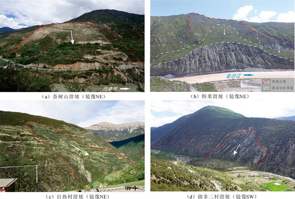
Fig.3 Field photos of typical landslides in the Batang fault zone

Fig.4 Landslide factor maps of the Batang fault zone
| 影响因子 | 分级 | 分区面积 /km2 | 总面积 占比/% | 滑坡面 积/km2 | 滑坡面积 占比/% | Wf值 | ||||||||||||
|---|---|---|---|---|---|---|---|---|---|---|---|---|---|---|---|---|---|---|
| 高程/m | <2 500 | 50.841 3 | 0.51 | 2.786 3 | 4.06 | 2.120 4 | -0.036 6 | 2.156 9 | ||||||||||
| 2 500~3 000 | 444.390 0 | 4.47 | 24.585 6 | 35.82 | 2.130 4 | -0.400 0 | 2.530 4 | |||||||||||
| 3 000~3 500 | 861.614 4 | 8.67 | 27.727 5 | 40.40 | 1.564 4 | -0.429 2 | 1.993 5 | |||||||||||
| 3 500~4 000 | 1 816.745 0 | 18.29 | 12.549 4 | 18.28 | -0.000 2 | 0 | -0.000 2 | |||||||||||
| 4 000~5 000 | 6 414.440 6 | 64.57 | 0.986 3 | 1.44 | -3.812 0 | 1.035 5 | -4.847 5 | |||||||||||
| >5 000 | 346.404 4 | 3.49 | 0.00 | 0.0 | ||||||||||||||
| 坡度/ (°) | 0~10 | 1 943.985 0 | 19.57 | 10.315 0 | 15.03 | -0.265 5 | 0.055 3 | -0.678 1 | ||||||||||
| 10~20 | 1 680.376 9 | 16.91 | 6.450 0 | 9.40 | -0.590 8 | 0.087 2 | 1.436 7 | |||||||||||
| 20~30 | 3 110.125 6 | 31.31 | 25.097 5 | 36.57 | 0.556 5 | -0.880 2 | 0.584 3 | |||||||||||
| 30~40 | 2 385.433 1 | 24.01 | 20.178 1 | 29.40 | 0.704 0 | -0.574 0 | 0.175 4 | |||||||||||
| >40 | 814.514 4 | 8.20 | 6.594 4 | 9.61 | 0.159 8 | -0.015 6 | -0.320 8 | |||||||||||
| 坡向 | 平坦(无坡向) | 1 847.269 4 | 18.59 | 10.401 3 | 15.15 | -0.205 9 | 0.041 7 | -0.247 5 | ||||||||||
| N | 475.745 0 | 4.79 | 2.303 1 | 3.36 | -0.357 7 | 0.015 0 | -0.372 8 | |||||||||||
| NE | 1 113.393 1 | 11.21 | 5.816 3 | 8.47 | -0.281 2 | 0.030 5 | -0.311 8 | |||||||||||
| E | 1 143.394 4 | 11.51 | 5.551 3 | 8.09 | -0.354 8 | 0.038 2 | -0.393 0 | |||||||||||
| SE | 993.125 0 | 10.00 | 4.421 9 | 6.44 | -0.441 8 | 0.039 0 | -0.480 8 | |||||||||||
| S | 908.413 8 | 9.14 | 5.654 4 | 8.24 | -0.105 0 | 0.010 0 | -0.115 0 | |||||||||||
| SW | 1 194.700 6 | 12.03 | 9.852 5 | 14.35 | 0.178 4 | -0.027 0 | 0.205 4 | |||||||||||
| W | 1 194.701 9 | 12.03 | 13.945 0 | 20.32 | 0.529 2 | -0.099 6 | 0.628 9 | |||||||||||
| NW | 1 063.692 5 | 10.71 | 10.689 4 | 15.57 | 0.377 9 | -0.056 4 | 0.434 3 | |||||||||||
| TWI | <10 | 8 303.741 9 | 83.59 | 58.089 4 | 84.84 | 0.014 8 | -0.079 0 | 0.093 8 | ||||||||||
| 10~20 | 271.928 8 | 2.74 | 2.102 5 | 3.07 | 0.115 6 | -0.003 5 | 0.119 1 | |||||||||||
| >20 | 1 356.616 3 | 13.66 | 8.276 9 | 12.09 | -0.122 9 | 0.018 1 | -0.141 1 | |||||||||||
| 距断裂的 距离/m | 0~500 | 696.294 4 | 7.01 | 13.358 8 | 19.37 | 1.033 3 | -0.143 8 | 1.177 1 | ||||||||||
| 500~100 0 | 663.798 8 | 6.68 | 10.997 5 | 15.94 | 0.883 9 | -0.105 5 | 0.989 4 | |||||||||||
| 1 000~2 000 | 1 246.383 8 | 12.55 | 15.737 5 | 22.81 | 0.608 3 | -0.126 4 | 0.734 6 | |||||||||||
| 2 000~5 000 | 2 982.946 9 | 30.03 | 20.767 5 | 30.11 | 0.007 2 | -0.003 1 | 0.010 3 | |||||||||||
| 5 000~10 000 | 2 868.790 6 | 28.88 | 7.336 9 | 10.64 | -0.998 7 | 0.228 2 | -1.226 9 | |||||||||||
| >10 000 | 1 521.397 5 | 15.31 | 0.783 8 | 1.14 | -2.603 0 | 0.155 1 | -2.758 2 | |||||||||||
| 工程地 质岩组 | 1 | 17.839 4 | 0.18 | 1.356 9 | 1.97 | 2.471 2 | -0.018 2 | 2.489 5 | ||||||||||
| 2 | 867.818 8 | 8.74 | 1.161 3 | 1.68 | -1.646 8 | 0.074 5 | -1.721 3 | |||||||||||
| 3 | 649.206 3 | 6.53 | 0.00 | 0.0 | ||||||||||||||
| 4 | 261.644 4 | 2.63 | 0.936 3 | 1.36 | -0.660 9 | 0.013 0 | -0.673 9 | |||||||||||
| 5 | 1 160.734 4 | 11.68 | 2.856 3 | 4.14 | -1.036 5 | 0.081 9 | -1.118 4 | |||||||||||
| 6 | 672.953 8 | 6.77 | 1.630 0 | 2.36 | -1.052 3 | 0.046 2 | -1.098 5 | |||||||||||
| 7 | 1 452.033 1 | 14.62 | 25.143 8 | 36.48 | 0.929 7 | -0.298 4 | 1.228 1 | |||||||||||
| 8 | 26.211 9 | 0.26 | 0.00 | 0.0 | ||||||||||||||
| 9 | 2 264.220 0 | 22.79 | 17.775 0 | 25.79 | 0.129 0 | -0.041 2 | 0.170 3 | |||||||||||
| 10 | 553.790 0 | 5.57 | 7.636 3 | 11.08 | 0.698 4 | -0.060 7 | 0.759 1 | |||||||||||
| 11 | 1 776.793 8 | 17.89 | 10.428 1 | 15.13 | -0.163 8 | 0.032 2 | -0.196 1 | |||||||||||
| 12 | 276.243 8 | 2.78 | 0.00 | 0.0 | ||||||||||||||
| 年平均降 雨量/mm | <500 | 4 589.000 0 | 46.19 | 43.576 3 | 63.31 | 0.322 3 | -0.389 0 | 0.711 3 | ||||||||||
| 500~550 | 3 364.750 0 | 33.87 | 23.926 9 | 34.76 | 0.030 7 | -0.016 0 | 0.046 7 | |||||||||||
| 550~600 | 1 764.750 0 | 17.76 | 1.326 3 | 1.93 | -2.222 9 | 0.176 5 | -2.399 4 | |||||||||||
| >600 | 260.750 0 | 2.62 | 0.00 | 0.0 | ||||||||||||||
| 影响因子 | 分级 | 分区面积 /km2 | 总面积 占比/% | 滑坡 面积/km2 | 滑坡面积数 占比/% | Wf值 | ||||||||||||
| 距河流的 距离/m | 0~100 | 89.357 5 | 0.90 | 3.264 4 | 4.73 | 1.695 1 | -0.039 8 | 1.734 9 | ||||||||||
| 100~300 | 178.609 4 | 1.80 | 6.383 8 | 9.25 | 1.672 4 | -0.079 6 | 1.752 0 | |||||||||||
| 300~800 | 444.866 3 | 4.48 | 15.143 8 | 21.95 | 1.621 9 | -0.203 5 | 1.825 5 | |||||||||||
| 800~1 500 | 615.719 4 | 6.20 | 14.021 9 | 20.33 | 1.208 3 | -0.164 6 | 1.373 0 | |||||||||||
| 1 500~2 500 | 869.543 1 | 8.75 | 16.843 8 | 24.42 | 1.043 1 | -0.190 0 | 1.233 0 | |||||||||||
| >2 500 | 7 781.165 6 | 78.33 | 13.324 4 | 19.32 | -1.400 7 | 1.317 0 | -2.717 7 | |||||||||||
| 距道路的 距离/m | 0~500 | 156.173 1 | 1.57 | 7.701 3 | 11.17 | 2.008 9 | -0.103 3 | 2.112 3 | ||||||||||
| 500~1 000 | 151.2 900 | 1.52 | 4.636 9 | 6.72 | 1.513 9 | -0.054 7 | 1.568 6 | |||||||||||
| 1 000~2 000 | 294.876 9 | 2.97 | 6.207 5 | 9.00 | 1.128 4 | -0.064 8 | 1.1932 | |||||||||||
| 2 000~4 000 | 562.218 8 | 5.66 | 8.351 3 | 12.11 | 0.773 4 | -0.071 6 | 0.845 0 | |||||||||||
| 4 000~8 000 | 1 056.659 4 | 10.64 | 11.163 1 | 16.19 | 0.428 3 | -0.065 1 | 0.493 5 | |||||||||||
| >8 000 | 7 758.213 8 | 78.09 | 30.890 6 | 44.80 | -0.554 1 | 0.918 6 | -1.472 7 | |||||||||||
| NDVI | <0 | 1.002 5 | 0.01 | 0 | 0 | |||||||||||||
| 0~0.2 | 478.665 6 | 4.82 | 0 | 0 | ||||||||||||||
| 0.2~0.4 | 1 196.983 8 | 12.05 | 1.415 0 | 2.07 | -1.764 8 | 0.107 7 | -1.872 5 | |||||||||||
| 0.4~0.6 | 2 338.163 8 | 23.54 | 13.040 6 | 19.04 | -0.209 0 | 0.056 2 | -0.265 2 | |||||||||||
| 0.6~0.8 | 4 141.938 8 | 41.69 | 40.657 5 | 59.35 | 0.360 6 | -0.366 1 | 0.726 6 | |||||||||||
| >0.8 | 1 821.836 3 | 18.34 | 13.388 8 | 19.55 | 0.068 6 | -0.016 0 | 0.084 6 | |||||||||||
Table 1 WOE calculation results of landslide susceptibility assessment along the Batang fault zone
| 影响因子 | 分级 | 分区面积 /km2 | 总面积 占比/% | 滑坡面 积/km2 | 滑坡面积 占比/% | Wf值 | ||||||||||||
|---|---|---|---|---|---|---|---|---|---|---|---|---|---|---|---|---|---|---|
| 高程/m | <2 500 | 50.841 3 | 0.51 | 2.786 3 | 4.06 | 2.120 4 | -0.036 6 | 2.156 9 | ||||||||||
| 2 500~3 000 | 444.390 0 | 4.47 | 24.585 6 | 35.82 | 2.130 4 | -0.400 0 | 2.530 4 | |||||||||||
| 3 000~3 500 | 861.614 4 | 8.67 | 27.727 5 | 40.40 | 1.564 4 | -0.429 2 | 1.993 5 | |||||||||||
| 3 500~4 000 | 1 816.745 0 | 18.29 | 12.549 4 | 18.28 | -0.000 2 | 0 | -0.000 2 | |||||||||||
| 4 000~5 000 | 6 414.440 6 | 64.57 | 0.986 3 | 1.44 | -3.812 0 | 1.035 5 | -4.847 5 | |||||||||||
| >5 000 | 346.404 4 | 3.49 | 0.00 | 0.0 | ||||||||||||||
| 坡度/ (°) | 0~10 | 1 943.985 0 | 19.57 | 10.315 0 | 15.03 | -0.265 5 | 0.055 3 | -0.678 1 | ||||||||||
| 10~20 | 1 680.376 9 | 16.91 | 6.450 0 | 9.40 | -0.590 8 | 0.087 2 | 1.436 7 | |||||||||||
| 20~30 | 3 110.125 6 | 31.31 | 25.097 5 | 36.57 | 0.556 5 | -0.880 2 | 0.584 3 | |||||||||||
| 30~40 | 2 385.433 1 | 24.01 | 20.178 1 | 29.40 | 0.704 0 | -0.574 0 | 0.175 4 | |||||||||||
| >40 | 814.514 4 | 8.20 | 6.594 4 | 9.61 | 0.159 8 | -0.015 6 | -0.320 8 | |||||||||||
| 坡向 | 平坦(无坡向) | 1 847.269 4 | 18.59 | 10.401 3 | 15.15 | -0.205 9 | 0.041 7 | -0.247 5 | ||||||||||
| N | 475.745 0 | 4.79 | 2.303 1 | 3.36 | -0.357 7 | 0.015 0 | -0.372 8 | |||||||||||
| NE | 1 113.393 1 | 11.21 | 5.816 3 | 8.47 | -0.281 2 | 0.030 5 | -0.311 8 | |||||||||||
| E | 1 143.394 4 | 11.51 | 5.551 3 | 8.09 | -0.354 8 | 0.038 2 | -0.393 0 | |||||||||||
| SE | 993.125 0 | 10.00 | 4.421 9 | 6.44 | -0.441 8 | 0.039 0 | -0.480 8 | |||||||||||
| S | 908.413 8 | 9.14 | 5.654 4 | 8.24 | -0.105 0 | 0.010 0 | -0.115 0 | |||||||||||
| SW | 1 194.700 6 | 12.03 | 9.852 5 | 14.35 | 0.178 4 | -0.027 0 | 0.205 4 | |||||||||||
| W | 1 194.701 9 | 12.03 | 13.945 0 | 20.32 | 0.529 2 | -0.099 6 | 0.628 9 | |||||||||||
| NW | 1 063.692 5 | 10.71 | 10.689 4 | 15.57 | 0.377 9 | -0.056 4 | 0.434 3 | |||||||||||
| TWI | <10 | 8 303.741 9 | 83.59 | 58.089 4 | 84.84 | 0.014 8 | -0.079 0 | 0.093 8 | ||||||||||
| 10~20 | 271.928 8 | 2.74 | 2.102 5 | 3.07 | 0.115 6 | -0.003 5 | 0.119 1 | |||||||||||
| >20 | 1 356.616 3 | 13.66 | 8.276 9 | 12.09 | -0.122 9 | 0.018 1 | -0.141 1 | |||||||||||
| 距断裂的 距离/m | 0~500 | 696.294 4 | 7.01 | 13.358 8 | 19.37 | 1.033 3 | -0.143 8 | 1.177 1 | ||||||||||
| 500~100 0 | 663.798 8 | 6.68 | 10.997 5 | 15.94 | 0.883 9 | -0.105 5 | 0.989 4 | |||||||||||
| 1 000~2 000 | 1 246.383 8 | 12.55 | 15.737 5 | 22.81 | 0.608 3 | -0.126 4 | 0.734 6 | |||||||||||
| 2 000~5 000 | 2 982.946 9 | 30.03 | 20.767 5 | 30.11 | 0.007 2 | -0.003 1 | 0.010 3 | |||||||||||
| 5 000~10 000 | 2 868.790 6 | 28.88 | 7.336 9 | 10.64 | -0.998 7 | 0.228 2 | -1.226 9 | |||||||||||
| >10 000 | 1 521.397 5 | 15.31 | 0.783 8 | 1.14 | -2.603 0 | 0.155 1 | -2.758 2 | |||||||||||
| 工程地 质岩组 | 1 | 17.839 4 | 0.18 | 1.356 9 | 1.97 | 2.471 2 | -0.018 2 | 2.489 5 | ||||||||||
| 2 | 867.818 8 | 8.74 | 1.161 3 | 1.68 | -1.646 8 | 0.074 5 | -1.721 3 | |||||||||||
| 3 | 649.206 3 | 6.53 | 0.00 | 0.0 | ||||||||||||||
| 4 | 261.644 4 | 2.63 | 0.936 3 | 1.36 | -0.660 9 | 0.013 0 | -0.673 9 | |||||||||||
| 5 | 1 160.734 4 | 11.68 | 2.856 3 | 4.14 | -1.036 5 | 0.081 9 | -1.118 4 | |||||||||||
| 6 | 672.953 8 | 6.77 | 1.630 0 | 2.36 | -1.052 3 | 0.046 2 | -1.098 5 | |||||||||||
| 7 | 1 452.033 1 | 14.62 | 25.143 8 | 36.48 | 0.929 7 | -0.298 4 | 1.228 1 | |||||||||||
| 8 | 26.211 9 | 0.26 | 0.00 | 0.0 | ||||||||||||||
| 9 | 2 264.220 0 | 22.79 | 17.775 0 | 25.79 | 0.129 0 | -0.041 2 | 0.170 3 | |||||||||||
| 10 | 553.790 0 | 5.57 | 7.636 3 | 11.08 | 0.698 4 | -0.060 7 | 0.759 1 | |||||||||||
| 11 | 1 776.793 8 | 17.89 | 10.428 1 | 15.13 | -0.163 8 | 0.032 2 | -0.196 1 | |||||||||||
| 12 | 276.243 8 | 2.78 | 0.00 | 0.0 | ||||||||||||||
| 年平均降 雨量/mm | <500 | 4 589.000 0 | 46.19 | 43.576 3 | 63.31 | 0.322 3 | -0.389 0 | 0.711 3 | ||||||||||
| 500~550 | 3 364.750 0 | 33.87 | 23.926 9 | 34.76 | 0.030 7 | -0.016 0 | 0.046 7 | |||||||||||
| 550~600 | 1 764.750 0 | 17.76 | 1.326 3 | 1.93 | -2.222 9 | 0.176 5 | -2.399 4 | |||||||||||
| >600 | 260.750 0 | 2.62 | 0.00 | 0.0 | ||||||||||||||
| 影响因子 | 分级 | 分区面积 /km2 | 总面积 占比/% | 滑坡 面积/km2 | 滑坡面积数 占比/% | Wf值 | ||||||||||||
| 距河流的 距离/m | 0~100 | 89.357 5 | 0.90 | 3.264 4 | 4.73 | 1.695 1 | -0.039 8 | 1.734 9 | ||||||||||
| 100~300 | 178.609 4 | 1.80 | 6.383 8 | 9.25 | 1.672 4 | -0.079 6 | 1.752 0 | |||||||||||
| 300~800 | 444.866 3 | 4.48 | 15.143 8 | 21.95 | 1.621 9 | -0.203 5 | 1.825 5 | |||||||||||
| 800~1 500 | 615.719 4 | 6.20 | 14.021 9 | 20.33 | 1.208 3 | -0.164 6 | 1.373 0 | |||||||||||
| 1 500~2 500 | 869.543 1 | 8.75 | 16.843 8 | 24.42 | 1.043 1 | -0.190 0 | 1.233 0 | |||||||||||
| >2 500 | 7 781.165 6 | 78.33 | 13.324 4 | 19.32 | -1.400 7 | 1.317 0 | -2.717 7 | |||||||||||
| 距道路的 距离/m | 0~500 | 156.173 1 | 1.57 | 7.701 3 | 11.17 | 2.008 9 | -0.103 3 | 2.112 3 | ||||||||||
| 500~1 000 | 151.2 900 | 1.52 | 4.636 9 | 6.72 | 1.513 9 | -0.054 7 | 1.568 6 | |||||||||||
| 1 000~2 000 | 294.876 9 | 2.97 | 6.207 5 | 9.00 | 1.128 4 | -0.064 8 | 1.1932 | |||||||||||
| 2 000~4 000 | 562.218 8 | 5.66 | 8.351 3 | 12.11 | 0.773 4 | -0.071 6 | 0.845 0 | |||||||||||
| 4 000~8 000 | 1 056.659 4 | 10.64 | 11.163 1 | 16.19 | 0.428 3 | -0.065 1 | 0.493 5 | |||||||||||
| >8 000 | 7 758.213 8 | 78.09 | 30.890 6 | 44.80 | -0.554 1 | 0.918 6 | -1.472 7 | |||||||||||
| NDVI | <0 | 1.002 5 | 0.01 | 0 | 0 | |||||||||||||
| 0~0.2 | 478.665 6 | 4.82 | 0 | 0 | ||||||||||||||
| 0.2~0.4 | 1 196.983 8 | 12.05 | 1.415 0 | 2.07 | -1.764 8 | 0.107 7 | -1.872 5 | |||||||||||
| 0.4~0.6 | 2 338.163 8 | 23.54 | 13.040 6 | 19.04 | -0.209 0 | 0.056 2 | -0.265 2 | |||||||||||
| 0.6~0.8 | 4 141.938 8 | 41.69 | 40.657 5 | 59.35 | 0.360 6 | -0.366 1 | 0.726 6 | |||||||||||
| >0.8 | 1 821.836 3 | 18.34 | 13.388 8 | 19.55 | 0.068 6 | -0.016 0 | 0.084 6 | |||||||||||
| 序号 | 工程地质岩组名称 | 主要地层代号 |
|---|---|---|
| 1 | 坚硬的厚层状砾岩砂岩岩组 | T3l |
| 2 | 较坚硬-坚硬的中-厚层状砂岩夹砾岩、泥岩、板岩岩组 | T3z,P1j |
| 3 | 软硬相间的中-厚层状砂岩、泥岩夹灰岩、泥质灰岩及其互层岩组 | SDr,T3w,P2,J,C1 |
| 4 | 弱-较坚硬薄-中厚层状砂、泥岩及砾、泥岩互层岩组 | T2-3j |
| 5 | 坚硬的中-厚层状灰岩及白云岩岩组 | T3g,Sg,P1m |
| 6 | 较坚硬的薄-中厚层状灰岩、泥质灰岩岩组 | Dg-t |
| 7 | 软硬相间的中-厚层状灰岩、白云岩夹砂、泥岩、千枚岩、板岩岩组 | T1-2m |
| 8 | 较坚硬-坚硬薄-中厚层状板岩、千枚岩与变质砂岩互层岩组 | D1-2h |
| 9 | 较弱-较坚硬的薄-中厚层状千枚岩、片岩夹灰岩、砂岩、火山岩岩组 | T1-2Y,P1e |
| 10 | 坚硬的块状玄武岩为主的岩组 | P2g,T3gl |
| 11 | 坚硬块状花岗岩、安山岩、闪长岩岩组 | Pt2-3N,Pt2D,T3MC,Tγδ,Jγδ,Jγ,Tγ,Eγ |
| 12 | 软质散体结构岩组 | Qp,Qh |
Table 2 Engineering geologic rock formation in the study area
| 序号 | 工程地质岩组名称 | 主要地层代号 |
|---|---|---|
| 1 | 坚硬的厚层状砾岩砂岩岩组 | T3l |
| 2 | 较坚硬-坚硬的中-厚层状砂岩夹砾岩、泥岩、板岩岩组 | T3z,P1j |
| 3 | 软硬相间的中-厚层状砂岩、泥岩夹灰岩、泥质灰岩及其互层岩组 | SDr,T3w,P2,J,C1 |
| 4 | 弱-较坚硬薄-中厚层状砂、泥岩及砾、泥岩互层岩组 | T2-3j |
| 5 | 坚硬的中-厚层状灰岩及白云岩岩组 | T3g,Sg,P1m |
| 6 | 较坚硬的薄-中厚层状灰岩、泥质灰岩岩组 | Dg-t |
| 7 | 软硬相间的中-厚层状灰岩、白云岩夹砂、泥岩、千枚岩、板岩岩组 | T1-2m |
| 8 | 较坚硬-坚硬薄-中厚层状板岩、千枚岩与变质砂岩互层岩组 | D1-2h |
| 9 | 较弱-较坚硬的薄-中厚层状千枚岩、片岩夹灰岩、砂岩、火山岩岩组 | T1-2Y,P1e |
| 10 | 坚硬的块状玄武岩为主的岩组 | P2g,T3gl |
| 11 | 坚硬块状花岗岩、安山岩、闪长岩岩组 | Pt2-3N,Pt2D,T3MC,Tγδ,Jγδ,Jγ,Tγ,Eγ |
| 12 | 软质散体结构岩组 | Qp,Qh |
| 评价因子 | 高程 | 坡度 | 坡向 | TWI | 距断裂的距离 | 岩性 | 降雨 | 距河流的距离 | 距道路的距离 | NDVI | 权重值(ai) |
|---|---|---|---|---|---|---|---|---|---|---|---|
| 高程 | 1 | 1/3 | 1/2 | 2 | 1/4 | 1/3 | 1 | 1/2 | 1/2 | 2 | 0.15 |
| 坡度 | 3 | 1 | 3 | 2 | 1 | 1/2 | 1/2 | 2 | 2 | 2 | 0.21 |
| 坡向 | 2 | 1/3 | 1 | 1/4 | 1/4 | 1/3 | 1/4 | 1/2 | 1/2 | 1/2 | 0.06 |
| TWI | 1/2 | 1/2 | 4 | 1 | 1 | 1/2 | 1/2 | 1/4 | 1 | 4 | 0.11 |
| 距断裂的距离 | 4 | 1 | 4 | 1 | 1 | 2 | 1 | 2 | 2 | 1 | 0.11 |
| 岩性 | 3 | 2 | 3 | 2 | 1/2 | 1 | 2 | 2 | 3 | 2 | 0.05 |
| 降雨 | 1 | 2 | 4 | 2 | 1 | 1/2 | 1 | 2 | 2 | 4 | 0.06 |
| 距河流的距离 | 2 | 1/2 | 2 | 4 | 1/2 | 1/2 | 1/2 | 1 | 2 | 1/2 | 0.09 |
| 距道路的距离 | 2 | 1/2 | 2 | 1 | 1/2 | 2/7 | 1/2 | 1/2 | 1 | 1 | 0.11 |
| NDVI | 1/2 | 1/2 | 2 | 1/4 | 1 | 1/2 | 1/4 | 2 | 1 | 1 | 0.05 |
Table 3 AHP judgment matrix and weighted value of landslide factors
| 评价因子 | 高程 | 坡度 | 坡向 | TWI | 距断裂的距离 | 岩性 | 降雨 | 距河流的距离 | 距道路的距离 | NDVI | 权重值(ai) |
|---|---|---|---|---|---|---|---|---|---|---|---|
| 高程 | 1 | 1/3 | 1/2 | 2 | 1/4 | 1/3 | 1 | 1/2 | 1/2 | 2 | 0.15 |
| 坡度 | 3 | 1 | 3 | 2 | 1 | 1/2 | 1/2 | 2 | 2 | 2 | 0.21 |
| 坡向 | 2 | 1/3 | 1 | 1/4 | 1/4 | 1/3 | 1/4 | 1/2 | 1/2 | 1/2 | 0.06 |
| TWI | 1/2 | 1/2 | 4 | 1 | 1 | 1/2 | 1/2 | 1/4 | 1 | 4 | 0.11 |
| 距断裂的距离 | 4 | 1 | 4 | 1 | 1 | 2 | 1 | 2 | 2 | 1 | 0.11 |
| 岩性 | 3 | 2 | 3 | 2 | 1/2 | 1 | 2 | 2 | 3 | 2 | 0.05 |
| 降雨 | 1 | 2 | 4 | 2 | 1 | 1/2 | 1 | 2 | 2 | 4 | 0.06 |
| 距河流的距离 | 2 | 1/2 | 2 | 4 | 1/2 | 1/2 | 1/2 | 1 | 2 | 1/2 | 0.09 |
| 距道路的距离 | 2 | 1/2 | 2 | 1 | 1/2 | 2/7 | 1/2 | 1/2 | 1 | 1 | 0.11 |
| NDVI | 1/2 | 1/2 | 2 | 1/4 | 1 | 1/2 | 1/4 | 2 | 1 | 1 | 0.05 |
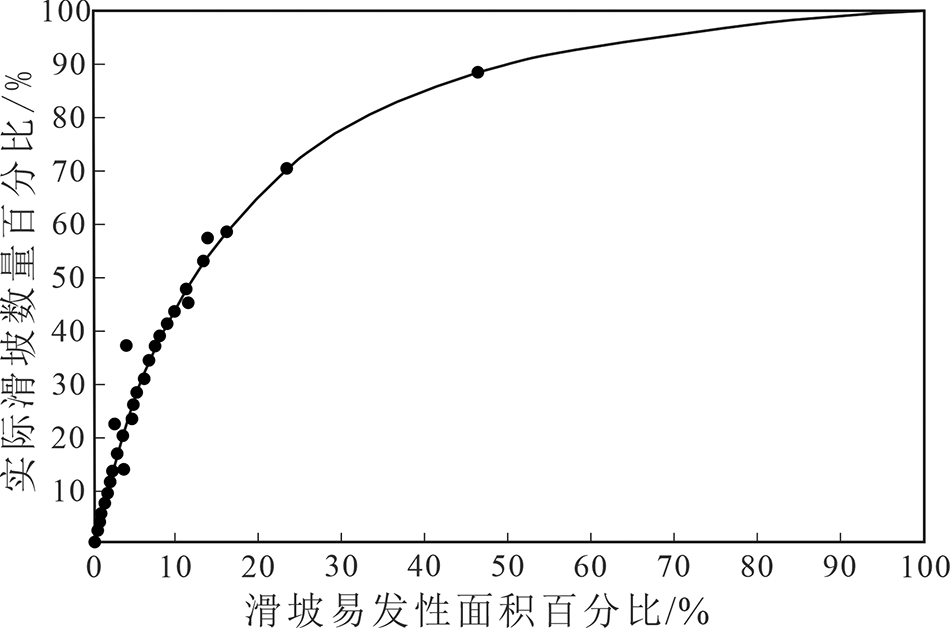
Fig.5 ROC curve for landslide susceptibility value of the Batang fault zone

Fig.6 Landslide susceptibility map of the Batang fault zone
| [1] | 黄润秋. 20世纪以来中国的大型滑坡及其发生机制[J]. 岩石力学与工程学报, 2007,26(3):433-454. |
| [2] | 张永双, 石菊松, 孙萍, 等. 汶川地震内外动力耦合及灾害实例[J]. 地质力学学报, 2009,15(2):131-141. |
| [3] | 郭长宝, 张永双, 蒋良文, 等. 川藏铁路沿线及邻区环境工程地质问题概论[J]. 现代地质, 2017,31(5):877-889. |
| [4] | 周荣军, 陈国星, 李勇, 等. 四川西部理塘—巴塘地区的活动断裂与1989年巴塘6.7级震群发震构造研究[J]. 地震地质, 2005,27(1):31-43. |
| [5] | 徐锡伟, 张培震, 闻学泽, 等. 川西及其邻近地区活动构造基本特征与强震复发模型[J]. 地震地质, 2005,27(3):446-461. |
| [6] | 吴瑞安, 郭长宝, 杜宇本, 等. 川藏铁路加查—朗县段地质灾害发育特征研究[J]. 现代地质, 2017,31(5):956-964. |
| [7] | 石菊松, 徐瑞春, 石玲, 等. 基于RS和GIS技术的清江隔河岩库区滑坡易发性评价与制图[J]. 地学前缘, 2007,14(6):119-128. |
| [8] | LEE S, EVANGELISTA D G. Earthquake-induced landslide-susceptibility mapping using an artificial neural network[J]. Natural Hazards and Earth System Sciences, 2006,6(5):687-695. |
| [9] | LAN Hengxing, ZHOU Chenghu, WANG Lingjuan, et al. Landslide hazard spatial analysis and prediction using GIS in the Xiaojiang watershed, Yunnan, China[J]. Engineering Geology, 2004,76(1/2):109-128. |
| [10] | TANGESTANI M H. A comparative study of Dempster-Shafer and fuzzy models for landslide susceptibility mapping using a GIS: An experience from Zagros Mountains, SW Iran[J]. Journal of Asian Earth Sciences, 2009,35(1):66-73. |
| [11] | LI Langping, LAN Hengxing, GUO Changbao, et al. A modified frequency ratio method for landslide susceptibility assessment[J]. Landslides, 2017,14(2):727-741. |
| [12] | 白永健, 郑万模, 李明辉, 等. 川藏公路茶树山滑坡特征及成因机制分析[J]. 工程地质学报, 2010,18(6):862-866. |
| [13] | 任三绍, 郭长宝, 张永双, 等. 川西巴塘茶树山滑坡发育特征及形成机理[J]. 现代地质, 2017,31(5):978-989. |
| [14] | 范强, 巨能攀, 向喜琼, 等. 证据权法在区域滑坡危险性评价中的应用——以贵州省为例[J]. 工程地质学报, 2014,22(3):474-481. |
| [15] | GUO Changbao, MONTGOMERY D R, ZHANG Yongshuang, et al. Quantitative assessment of landslide susceptibility along the Xianshuihe Fault zone, Tibetan Plateau, China[J]. Geomorphology, 2015,248:93-110. |
| [16] | 杨志华, 郭长宝, 姚鑫, 等. 考虑地震后效应的青藏高原东缘地质灾害易发性评价[J]. 中国地质灾害与防治学报, 2017,28(4):103-112. |
| [17] | 张晓东, 刘湘南, 赵志鹏, 等. 信息量模型、确定性系数模型与逻辑回归模型组合评价地质灾害敏感性的对比研究[J]. 现代地质, 2018,32(3):602-610. |
| [18] | DAHAL R K, HASEGAWA S, NONOMURA A, et al. Predictive modelling of rainfall-induced landslide hazard in the Lesser Himalaya of Nepal based on weights-of-evidence[J]. Geomorphology, 2008,102(3/4):496-510. |
| [19] | 张生元, 成秋明, 张素萍, 等. 加权证据权模型和逐步证据权模型及其在个旧锡铜矿产资源预测中的应用[J]. 地球科学——中国地质大学学报, 2009,34(2):281-286. |
| [20] | MOHAMMADY M, POURGHASEMI H R, PRADHAN B. Landslide susceptibility mapping at Golestan Province, Iran: A comparison between frequency ratio, Dempster-Shafer, and weights-of-evidence models[J]. Journal of Asian Earth Sciences, 2012,61:221-236. |
| [21] | 许冲, 徐锡伟, 于贵华. 基于证据权方法的玉树地震滑坡危险性评价[J]. 地震地质, 2013,35(1):151-163. |
| [22] | 郭长宝, 张永双, 蒋良文, 等. 基于GIS的滇藏铁路丽江—香格里拉段工程地质条件分区研究[J]. 现代地质, 2009,23(3):545-552. |
| [23] | 刘振军. 层次分析法在青藏高原中西部航磁异常分类及找矿预测中的应用[J]. 物探与化探, 2001,25(3):161-168. |
| [24] | HASEKIOĜULLAR G D, ERCANOGLU M. A new approach to use AHP in landslide susceptibility mapping: a case study at Yenice (Karabuk, NW Turkey)[J]. Natural Hazards, 2012,63(2):1157-1179. |
| [25] | 中国地质调查局. 地质灾害调查技术要求(1:50,000) (DD2019-08)[S]. 2019. |
| Viewed | ||||||
|
Full text |
|
|||||
|
Abstract |
|
|||||