

现代地质 ›› 2023, Vol. 37 ›› Issue (01): 153-163.DOI: 10.19657/j.geoscience.1000-8527.2022.019
赵忠海1( ), 陈俊1, 乔锴1, 崔晓梦1, 梁杉杉1, 李成禄2
收稿日期:2021-10-01
修回日期:2022-03-04
出版日期:2023-02-10
发布日期:2023-03-20
作者简介:赵忠海,男,副教授,博士生导师,1984年出生,矿物学、岩石学、矿床学专业,主要从事矿产勘查和矿床学研究。Email:zhaozhonghai@lntu.edu.cn。
基金资助:
ZHAO Zhonghai1(), CHEN Jun1, QIAO Kai1, CUI Xiaomeng1, LIANG Shanshan1, LI Chenglu2
Received:2021-10-01
Revised:2022-03-04
Online:2023-02-10
Published:2023-03-20
摘要:
矿化蚀变信息提取和构造解译对于成矿预测具有重要意义,分形理论在遥感地质领域可用于揭示隐藏于复杂地形地物信息的精细结构,为遥感矿化蚀变信息提取和解译地质构造的定量分析提供理论基础和新方法。利用Landsat-8 OLI影像与相关的地质资料,基于分形理论研究黑龙江多宝山地区的蚀变信息与构造分形特征。采用“去干扰+波段比值+主成分分析+分形阈值分割”方法对蚀变异常信息进行提取,利用分形理论的盒维数法分别得到线性构造与蚀变信息分维等值线图,分析其空间展布及分形特征;并将构造和蚀变信息叠加与构造、蚀变分维高值区进行对比,同时与成矿地质背景进行比较。结果表明,遥感蚀变分维高值区与蚀变信息密集区一致,构造分形结果与成矿构造空间展布情况一致,叠加信息兼并了两者的优势信息,排除干扰缩小勘查范围,更为有效地突出了成矿有利部位。本文研究尝试了遥感蚀变异常与构造信息叠加的分形特征分析方法,不但可增加遥感信息利用度与精准性,同时分析结果反映其与实际成矿地质背景和勘查成果更加符合,可作为遥感信息综合找矿预测的一种新理论和新方法,也为研究区下一步勘查工作提供理论依据和找矿方向。
中图分类号:
赵忠海, 陈俊, 乔锴, 崔晓梦, 梁杉杉, 李成禄. 基于分形理论的遥感蚀变信息和构造分析研究:以黑龙江多宝山地区为例[J]. 现代地质, 2023, 37(01): 153-163.
ZHAO Zhonghai, CHEN Jun, QIAO Kai, CUI Xiaomeng, LIANG Shanshan, LI Chenglu. Remote Sensing Alteration and Structure Analysis Based on Fractal Theory: A Case Study of Duobaoshan Area of Heilongjiang Province[J]. Geoscience, 2023, 37(01): 153-163.
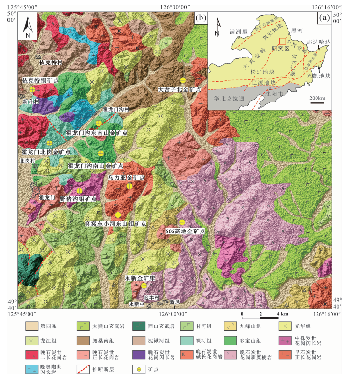
图 1 研究区大地构造位置图(a)和地质简图(b)
Fig.1 Tectonic map (a) and geological sketch map (b) of the study area
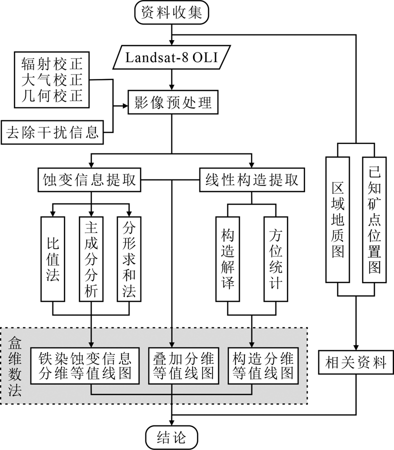
图2 数据处理流程图
Fig.2 Data processing flow chart
| 特征向量 | Band6/ Band7 | Band6/ Band2 | Band5/ Band4 | Band4/ Band2 |
|---|---|---|---|---|
| PC1 | 0.1866 | 0.8967 | 0.2707 | 0.2965 |
| PC2 | 0.5703 | -0.4283 | 0.3823 | 0.5875 |
| PC3 | -0.3402 | 0.0107 | -0.5971 | 0.7265 |
| PC4 | -0.7241 | -0.1113 | 0.6513 | 0.1978 |
表1 主成分分析统计结果
Table 1 Statistics of principal component analysis
| 特征向量 | Band6/ Band7 | Band6/ Band2 | Band5/ Band4 | Band4/ Band2 |
|---|---|---|---|---|
| PC1 | 0.1866 | 0.8967 | 0.2707 | 0.2965 |
| PC2 | 0.5703 | -0.4283 | 0.3823 | 0.5875 |
| PC3 | -0.3402 | 0.0107 | -0.5971 | 0.7265 |
| PC4 | -0.7241 | -0.1113 | 0.6513 | 0.1978 |
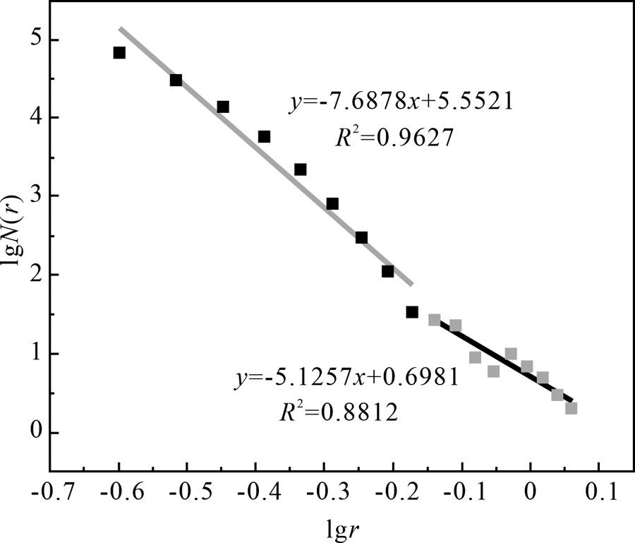
图3 lgN(r)-lgr图(灰度频数)
Fig.3 lgN(r)-lgr for grey frequency

图 4 基于分型的研究区铁染蚀变异常图(a)、镜铁矿化(b)和褐铁矿化(c)
Fig.4 Iron staining alteration anomaly map in the study area based on fractal statistics (a), mirror Fe mineralization (b), and ferritization (c)

图5 研究区铁染蚀变异常分维等值线图
Fig.5 Contour map for fractal dimension values of FCA in the study area

图6 研究区遥感解译构造解译图(a)、构造方位统计玫瑰图(b)和构造解译标志(c)
Fig.6 Remote sensing fault interpretation map (a), structural azimuth statistical rose chart (b) and structural interpretive markers (c) of the study area
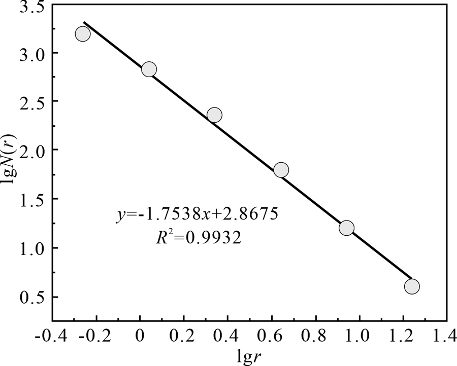
图7 全区线性构造分形统计结果lgN(r)-lgr图
Fig.7 lgN(r)-lgr for fractal statistical results
| 区域 | 分维值 | 资料来源 |
|---|---|---|
| 黑龙江多宝山地区构造 | 1.7538 | 本次计算 |
| 广西大瑶山西北地区构造 | 1.6897 | 蒋超等[ |
| 中国四川盆地中部断裂带 | 1.5300 | Fan[ |
| 中国上杭—云霄断裂带 | 1.3600 | Lyu[ |
| 西藏阿里住浪矿区线性构造 | 1.8412 | 张渊等[ |
| 湘南九嶷山地区断裂 | 1.1155 | 雷天赐等[ |
| 中国青藏高原地区断裂 | 1.2373 | 朱晓华[ |
| 中国大陆断裂 | 1.2366 | 朱晓华[ |
| 华南地区线性构造 | 1.3500 | 孔凡臣等[ |
| 日本岛弧线性构造 | <1.6000 | Hirata[ |
表2 研究区与其他地区线性构造分形特征比较
Table 2 Comparison of fractal characteristics of the study area with other areas
| 区域 | 分维值 | 资料来源 |
|---|---|---|
| 黑龙江多宝山地区构造 | 1.7538 | 本次计算 |
| 广西大瑶山西北地区构造 | 1.6897 | 蒋超等[ |
| 中国四川盆地中部断裂带 | 1.5300 | Fan[ |
| 中国上杭—云霄断裂带 | 1.3600 | Lyu[ |
| 西藏阿里住浪矿区线性构造 | 1.8412 | 张渊等[ |
| 湘南九嶷山地区断裂 | 1.1155 | 雷天赐等[ |
| 中国青藏高原地区断裂 | 1.2373 | 朱晓华[ |
| 中国大陆断裂 | 1.2366 | 朱晓华[ |
| 华南地区线性构造 | 1.3500 | 孔凡臣等[ |
| 日本岛弧线性构造 | <1.6000 | Hirata[ |

图8 研究区构造分维等值线图
Fig.8 Contour map of the fault fractal dimension values in the study area
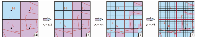
图9 分形维数尺度划分步骤示意图(r=4410 m)
Fig.9 Schematic diagrams of fractal dimension scale division steps
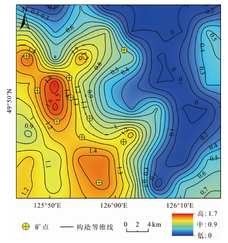
图10 蚀变信息与构造信息叠加分维等值线图
Fig.10 Contour map for fractal dimension values of integrating alteration and structural information
| [1] |
MANDELBROT B B. On the geometry of homogeneous turbulence, with stress on the fractal dimension of the iso-surfaces of scalars[J]. Journal of Fluid Mechanics, 1975, 72(3): 401-416.
DOI URL |
| [2] | 成秋明. 空间模式的广义自相似性分析与矿产资源评价[J]. 地球科学——中国地质大学学报, 2004, 29(6): 733-744. |
| [3] | 郝兴中, 张华平, 王巧云, 等. 山东德州超深覆盖区矽卡岩型铁矿找矿标志[J]. 地质论评, 2021, 67(增): 139-140. |
| [4] | 王钦军, 魏永明, 陈玉, 等. 低植被覆盖区斑岩铜矿遥感找矿模型及其应用:以环巴尔喀什—西准噶尔成矿带为例[J]. 地质学报, 2017, 91(2): 400-410. |
| [5] | OKUBO P G, AKI K. Fractal geometry in the San Andreas fault system[J]. Journal of Geophysical Research (Solid Earth), 1987, 92(B1): 345-355. |
| [6] | 李社, 管太阳, 曹双林, 等. 基于RS与分形的下庄矿田线性构造空间特征分析[J]. 遥感学报, 2007, 11(4): 493-499. |
| [7] | MEHRNIA R. Using fractal filtering technique for processing ETM data as main criteria for evaluating of gold indices in North West of Iran[M]// International Conference on Computer Technology and Development. IEEE Computer Society, 2009: 298-302. |
| [8] |
FOROUZAN M, ARFANIA R. Integration of the Bands of Aster, Oli, Msi remote sensing sensors for detection of hydrothermal alterations in southwestern area of the Ardestan, Isfahan Province, Central Iran[J]. The Egyptian Journal of Remote Sensing and Space Science, 2020, 23(2): 145-157.
DOI URL |
| [9] | ZAMANI N, LOTFI M, POURKERMANI M. Application of remote sensing and fractal modeling in identifying the alteration zones in Muteh Complex-Central Iran[J]. Revista Geoaraguaia, 2020, 10(2): 51-69. |
| [10] | 王倩, 陈建平. 基于分形理论的遥感蚀变异常提取和分级[J]. 地质通报, 2009, 28(增): 285-288. |
| [11] | 梁钰琦, 王功文, 朱彦彦, 等. 分形方法在遥感蚀变信息提取中的应用研究[J]. 遥感技术与应用, 2011, 26(4): 508-511. |
| [12] | 余敏, 温兴平, 徐俊龙, 等. 基于分形的遥感蚀变异常提取在毛坪铅锌矿中的应用[J]. 遥感技术与应用, 2014, 29(5): 853-860. |
| [13] |
AHMADIROUHANI R, KARIMPOUR M H, RAHIMI B, et al. Integration of spot-5 and aster satellite data for structural tracing and hydrothermal alteration mineral mapping: Implications for Cu-Au prospecting[J]. International Journal of Image and Data Fusion, 2018, 9(3): 237-262.
DOI URL |
| [14] |
AHMADFARAJ M, MIRMOHAMMADI M, AFZAL P, et al. Fractal modeling and fry analysis of the relationship between structures and Cu mineralization in Saveh Region, Central Iran[J]. Ore Geology Reviews, 2019, 107(1): 172-185.
DOI URL |
| [15] |
BEHYARI M, RAHIMSOURI Y, HOSEINZADEH E, et al. Evaluating of lithological and structural controls on the barite mineralization by using the remote sensing, fry and fractal methods, Northwest Iran[J]. Arabian Journal of Geosciences, 2019, 12(5): 167-178.
DOI |
| [16] |
SHIRAN M, ASADI M A Z, MOZZI P, et al. Detection of surface anomalies through fractal analysis and their relation to morphotectonics (High Zagros Belt, Iran)[J]. Geosciences Journal, 2020, 24(5): 597-613.
DOI |
| [17] | 蒋超, 李社宏, 付嵩, 等. 广西大瑶山西北地区构造分形与成矿预测[J]. 地球学报, 2021, 42(4): 514-526. |
| [18] | 雷天赐, 崔放, 余凤鸣, 等. 基于遥感技术的断裂构造分形特征及其地质意义研究:以湘南九嶷山地区为例[J]. 地质论评, 2012, 58(3): 594-600. |
| [19] | 赵忠海, 郑卫政, 曲晖, 等. 黑龙江多宝山地区铜金成矿作用及成矿规律[J]. 矿床地质, 2012, 31(3): 601-614. |
| [20] |
ZHOU J B, WILDE S A. The crustal accretion history and tectonic evolution of the NE China segment of the Central Asian Orogenic Belt[J]. Gondwana Research, 2013, 23(4): 1365-1377.
DOI URL |
| [21] | 刘翠, 邓晋福, 许立权, 等. 大兴安岭—小兴安岭地区中生代岩浆-构造-钼成矿地质事件序列的初步框架[J]. 地学前缘, 2011, 18(3): 166-178. |
| [22] |
HAO Y J, REN Y S, DUAN M X, et al. Mineralization time and tectonic setting of the Zhengguang Au deposit in the Duobaoshan ore field, Heilongjiang Province, NE China[J]. Arabian Journal of Geosciences, 2016, 15: 1-20.
DOI |
| [23] | WANG L, QIN K, SONG G, et al. Volcanic-subvolcanic rocks and tectonic setting of the Zhengguang intermediate sulfidation epithermal Au-Zn deposit, Eastern Central Asian Orogenic Belt, NE China[J]. Journal of Asian Earth Sciences, 2018, 23: 328-351. |
| [24] | 葛文春, 吴福元, 周长勇, 等. 兴蒙造山带东段斑岩型Cu,Mo矿床成矿时代及其地球动力学意义[J]. 科学通报, 2007, 52(20): 2407-2417. |
| [25] | 宋国学, 秦克章, 王乐, 等. 黑龙江多宝山矿田争光金矿床类型、U-Pb年代学及古火山机构[J]. 岩石学报, 2015, 31(8): 2402-2415. |
| [26] | 李成禄, 徐文喜, 于援帮, 等. 小兴安岭西北部与永新金矿有关岩浆岩的年代学和地球化学及成矿构造环境[J]. 现代地质, 2017, 31(6): 1114-1130. |
| [27] | 李成禄, 徐文喜, 李胜荣, 等. 大兴安岭东北部霍龙门地区早二叠世花岗岩的锆石U-Pb年龄、地球化学特征及构造意义[J]. 矿物岩石, 2017, 37(3): 46-54. |
| [28] | 赵忠海, 陈俊, 乔锴, 等. 小兴安岭西北部永新金矿床成矿流体来源与矿床成因:流体包裹体和H-O-S-Pb同位素证据[J]. 矿床地质, 2021, 40(2): 221-240. |
| [29] | 李运, 符家骏, 赵元艺, 等. 黑龙江争光金矿床年代学特征及成矿意义[J]. 地质学报, 2016, 90(1): 151-162. |
| [30] |
ZHAO Z H, SUN J G, LI G H, et al. Early Cretaceous gold mi-neralization in the Lesser Xing’an Range of NE China: The Yongxin example[J]. International Geology Review, 2019, 61(12): 1522-1549.
DOI URL |
| [31] |
ZHAO Z H, SUN J G, LI G H, et al. Age of the Yongxin Au deposit in the Lesser Xing'an Range: Implications for an Early Cretaceous geodynamic setting for gold mineralization in NE China[J]. Geological Journal, 2019, 54(4): 2525-2544.
DOI URL |
| [32] |
成功, 钟超岭, 袁海明, 等. 基于样本数据的红土型铝土矿定量遥感建模与反演研究[J]. 地学前缘, 2019, 26(4): 109-116.
DOI |
| [33] |
MCFEETERS S K. The use of the Normalized Difference Water Index (NDWI) in the delineation of open water features[J]. International Journal of Remote Sensing, 1996, 17(7): 1425-1432.
DOI URL |
| [34] | 徐涵秋. 利用改进的归一化差异水体指数(MNDWI)提取水体信息的研究[J]. 遥感学报, 2005, 9(5): 589-595. |
| [35] | 张玉君, 曾朝铭, 陈薇. ETM+(TM)蚀变遥感异常提取方法研究与应用——方法选择和技术流程[J]. 国土资源遥感, 2003, 56(2): 44-49,78. |
| [36] | CROSTA A P, MOORE J. Enhancement of Landsat thematic mapper imagery for residual soil mapping in SW Minas Gerais State, Brazil: A prospecting case history in Greenstone belt terrain[M]// Proceedings of the Seventh Thematic Conference on Remote Sensing for Exploration Geology. Calgary: ERIM, 1990: 1173-1187. |
| [37] | 申维. 分形混沌与矿产预测[M]. 北京: 地质出版社, 2002: 6-48. |
| [38] | 赵迪斐, 师庆民, 张喜松, 等. 基于分形的遥感蚀变提取及成矿预测:以青海野马泉地区为例[J]. 中国矿业, 2012, 21(9): 76-78. |
| [39] | 陈赶良, 杨柏林. 分维——利用遥感线性体预测矿床的新参量[J]. 地质与勘探, 1996, 32(2): 37-39. |
| [40] | 刘晓薇. 基于分形的遥感矿化信息提取研究[D]. 北京: 中国地质大学(北京), 2017: 21-51. |
| [41] | 王润生, 熊盛青, 聂洪峰, 等. 遥感地质勘查技术与应用研究[J]. 地质学报, 2011, 85(11): 1699-1743. |
| [42] | 张玉君, 杨建民, 陈薇. ETM+(TM)蚀变遥感异常提取方法研究与应用——地质依据和波谱前提[J]. 国土资源遥感, 2002, 54(4): 30-36. |
| [43] | 于岩, 李建国, 陈圣波, 等. 基于不同岩性背景的遥感影像蚀变矿物信息提取[J]. 地球科学, 2015, 40(8): 1391-1405. |
| [44] | 赵小星. 西藏桑木岗地区遥感线性构造和蚀变信息提取与找矿预测[J]. 现代地质, 2017, 31(4): 851-859. |
| [45] | 郭艳, 赵忠海, 曲晖, 等. 黑龙江多宝山地区遥感找矿蚀变异常提取方法研究[J]. 地质科技情报, 2011, 30(2): 117-121. |
| [46] | 赵少杰, 钱建平, 陈宏毅. 遥感线性构造分形统计和蚀变信息提取在桂东地区金铅锌锡多金属成矿预测中的应用[J]. 大地构造与成矿学, 2011, 35(3): 364-371. |
| [47] | 谢焱石, 谭凯旋, 郝涛. 构造-流体-成矿作用的分形与混沌动力学[J]. 大地构造与成矿学, 2010, 34(3): 378-385. |
| [48] | 谭凯旋, 谢焱石. 新疆阿尔泰地区断裂控矿的多重分形机理[J]. 大地构造与成矿学, 2010, 34(1): 32-39. |
| [49] | 林楠. 基于遥感地质与地球化学信息的成矿预测模型研究[D]. 长春: 吉林大学, 2015: 37-42. |
| [50] | 郭娜, 陈建平, 唐菊兴, 等. 基于RS技术的西藏甲玛铜多金属矿外围成矿预测研究[J]. 地学前缘, 2010, 17(4): 280-289. |
| [51] |
FAN C, QIN Q, HU D, et al. Fractal characteristics of reservoir structural fracture: A case study of Xujiahe Formation in Central Yuanba area, Sichuan Basin[J]. Earth Sciences Research Journal, 2018, 22(2): 113-118.
DOI URL |
| [52] |
LYU C, CHENG Q, ZUO R, et al. Mapping spatial distribution characteristics of lineaments extracted from remote sensing image using fractal and multifractal models[J]. Journal of Earth Science, 2017, 28(3): 507-515.
DOI URL |
| [53] | 张渊, 钱建平, 谢彪武, 等. 遥感蚀变和线性构造信息提取在西藏阿里住浪矿区一带的找矿应用[J]. 现代地质, 2013, 27(1): 99-107. |
| [54] | 朱晓华. 中国主要地貌与地质灾害的空间分维及其关系研究[D]. 南京: 南京师范大学, 2002: 76-82. |
| [55] | 孔凡臣, 丁国瑜. 线性构造分数维值的含义[J]. 地震, 1991, 11(5): 33-37. |
| [56] |
HIRATA T. Fractal dimension of fault systems in Japan: Fractal structure in rock fracture geometry at various scales[J]. Pure and Applied Geophysics, 1989, 131(1): 157-70.
DOI URL |
| [1] | 冯博, 段培新, 程旭, 卢辉雄, 李瑞炜, 张恩, 汪冰. 高分五号航天高光谱遥感技术在甘肃龙首山铀矿找矿中的应用[J]. 现代地质, 2022, 36(06): 1594-1604. |
| [2] | 姜秉仁, 邓恩德, 韩明辉, 马子杰. 黔西北地区石炭系祥摆组页岩微观孔隙结构及分形特征[J]. 现代地质, 2022, 36(04): 1065-1073. |
| [3] | 连琛芹, 姚佛军, 陈懋弘, 马克忠, 王海龙. GF-5高光谱数据在植被覆盖区的蚀变信息提取研究——以广东省玉水铜矿为例[J]. 现代地质, 2020, 34(04): 680-686. |
| [4] | 连琛芹, 姚佛军, 杨建民, 耿新霞, 崔舜铫, 蒲万峰, 张志刚. 半裸露区遥感蚀变信息提取研究——以甘肃玛曲地区为例[J]. 现代地质, 2019, 33(05): 1079-1085. |
| [5] | 赵小星. 西藏桑木岗地区遥感线性构造和蚀变信息提取与找矿预测[J]. 现代地质, 2017, 31(04): 851-859. |
| [6] | 钱建平,赵小星,唐善法,陈珊珊. 黔西南植被覆盖区遥感构造和植被异常信息提取:金矿找矿预测[J]. 现代地质, 2014, 28(4): 772-781. |
| [7] | 张渊,钱建平,谢彪武,赵小星. 遥感蚀变和线性构造信息提取在西藏阿里住浪矿区一带的找矿应用[J]. 现代地质, 2013, 27(1): 99-107. |
| [8] | 王乐, 何政伟, 刘婷婷, 倪忠云, 高慧, 蔡柯柯, 张船红, 吴华. 西藏尼雄铜铁多金属成矿带遥感找矿模式与找矿方向[J]. 现代地质, 2012, 26(3): 489-497. |
| [9] | 沈利霞,刘丽萍,苏新旭,祝艳,赵芳. 不同植被覆盖率地区遥感矿化蚀变提取研究[J]. 现代地质, 2008, 22(2): 293-298. |
| [10] | 杨圣彬 侯贵廷 郭庆银 潘立银 孙晔. 鄂尔多斯盆地西缘北段逆冲推覆带缩短量分形研究[J]. 现代地质, 2006, 20(1): 35-41. |
| [11] | 程博,刘少峰,梅雪峰. 利用多光谱遥感数据提取植被污染信息的新方法[J]. 现代地质, 2005, 19(3): 458-464. |
| [12] | 杨波,李京,陈云浩,赖健清,曾新平,唐攀科. 甘肃鹰嘴山地区岩体和隐伏岩体遥感信息提取研究[J]. 现代地质, 2005, 19(3): 465-470. |
| 阅读次数 | ||||||
|
全文 |
|
|||||
|
摘要 |
|
|||||