

Geoscience ›› 2017, Vol. 31 ›› Issue (05): 930-942.
• Research on the Main Geohazards and Engineering Geological Problems Along the SichuanTibet Railway • Previous Articles Next Articles
SU Fangrui1,2( ), GUO Changbao2,3(), ZHANG Xueke2, SHEN Wei1, LIU Xiaoyi2, REN Sanshao1,2
Received:2016-10-12
Revised:2017-06-10
Online:2017-10-10
Published:2017-11-06
CLC Number:
SU Fangrui, GUO Changbao, ZHANG Xueke, SHEN Wei, LIU Xiaoyi, REN Sanshao. Remote Sensing Interpretation of Large Landslides Along Sichuan-Tibet Railway Based on Object-oriented Classification Method[J]. Geoscience, 2017, 31(05): 930-942.

Fig.1 Geomorphologic features along the Sichuan-Tibet Railway and its adjacent areas
| 数据类型 | 光谱特征 | 空间分辨率/m | 可解译范围 | 优、缺点 | 相关应用 |
|---|---|---|---|---|---|
| Landsat | 多光谱7个波段 全色1个波段 | 全色影像15 多光谱30 | 植被覆盖区与裸露区 大型滑坡灾害 | 价格较低处理方便 空间分辨率低 | 大型滑坡遥感解 译研究[ |
| Spot-5 | 多光谱4个波段 全色1个波段 | 全色影像2.5 多光谱10 | 中、小型滑坡 城镇房屋、道路等 | 价格较低覆盖范围较大 空间分辨率适中 | 滑坡灾害定性分析 与定量监测[ |
| QuickBird | 多光谱4个波段 全色1个波段 | 全色影像0.61 多光谱2.4 | 滑坡体上大型冲沟 道路、房屋 | 价格较高覆盖范围小 空间分辨率高 | 灾害体定量分析[ |
| WorldView-2 | 多光谱4个波段 全色1个波段 | 全色影像0.5 多光谱2.0 | 岩性识别 对象纹理特征 | 价格昂贵覆盖范围小 空间分辨率极高 | 基于地形因子的面 向对象滑坡识别[ |
Table 1 Comparison and analysis of different types of remote sensing image interpretation
| 数据类型 | 光谱特征 | 空间分辨率/m | 可解译范围 | 优、缺点 | 相关应用 |
|---|---|---|---|---|---|
| Landsat | 多光谱7个波段 全色1个波段 | 全色影像15 多光谱30 | 植被覆盖区与裸露区 大型滑坡灾害 | 价格较低处理方便 空间分辨率低 | 大型滑坡遥感解 译研究[ |
| Spot-5 | 多光谱4个波段 全色1个波段 | 全色影像2.5 多光谱10 | 中、小型滑坡 城镇房屋、道路等 | 价格较低覆盖范围较大 空间分辨率适中 | 滑坡灾害定性分析 与定量监测[ |
| QuickBird | 多光谱4个波段 全色1个波段 | 全色影像0.61 多光谱2.4 | 滑坡体上大型冲沟 道路、房屋 | 价格较高覆盖范围小 空间分辨率高 | 灾害体定量分析[ |
| WorldView-2 | 多光谱4个波段 全色1个波段 | 全色影像0.5 多光谱2.0 | 岩性识别 对象纹理特征 | 价格昂贵覆盖范围小 空间分辨率极高 | 基于地形因子的面 向对象滑坡识别[ |
| 重点研究 区域 | 采用数据 类型 | 数据 标识 | 影像获取时间 (年/月/日) |
|---|---|---|---|
| 茶树山 滑坡 | Landsat-7 | LE71320392006264PFS00 | 2006/09/21 |
| WorldView-2 | 054047621040_01 | 2012/12/30 | |
| 102道班 滑坡 | Landsat-7 | LE71350392000125SGS00 | 2000/05/04 |
| WorldView-2 | 054047621020_01 | 2006/10/30 | |
| 八宿怒 江滑坡 | Landsat-8 | LC81340392013225LGN00 | 2013/08/13 |
| WorldView-2 | 054047621060_01 | 2014/01/04 | |
| 乱石包 滑坡 | Landsat-7 | LE71320392000280SGS00 | 2001/10/06 |
| WorldView-2 | 054047621050_01 | 2011/03/02 |
Table 2 Parameters of remote sensing data used in this study
| 重点研究 区域 | 采用数据 类型 | 数据 标识 | 影像获取时间 (年/月/日) |
|---|---|---|---|
| 茶树山 滑坡 | Landsat-7 | LE71320392006264PFS00 | 2006/09/21 |
| WorldView-2 | 054047621040_01 | 2012/12/30 | |
| 102道班 滑坡 | Landsat-7 | LE71350392000125SGS00 | 2000/05/04 |
| WorldView-2 | 054047621020_01 | 2006/10/30 | |
| 八宿怒 江滑坡 | Landsat-8 | LC81340392013225LGN00 | 2013/08/13 |
| WorldView-2 | 054047621060_01 | 2014/01/04 | |
| 乱石包 滑坡 | Landsat-7 | LE71320392000280SGS00 | 2001/10/06 |
| WorldView-2 | 054047621050_01 | 2011/03/02 |

Fig.2 Flow charts of object-oriented image processing

Fig.3 Images of Chashushan before and after landslide occurrence
| 特征对象 | 归一化植被指数(NDVI) | 高程/m | 坡度/(°) | 长宽比 | 灰度共生矩阵均值(GLCM Mean) |
|---|---|---|---|---|---|
| 特征值范围 | [-0.1,0.29] | [2 570,2 795] | [20,42] | [1,1.9] | [21.3,42.6] |
Table 3 Extraction rule of Chashushan landslide
| 特征对象 | 归一化植被指数(NDVI) | 高程/m | 坡度/(°) | 长宽比 | 灰度共生矩阵均值(GLCM Mean) |
|---|---|---|---|---|---|
| 特征值范围 | [-0.1,0.29] | [2 570,2 795] | [20,42] | [1,1.9] | [21.3,42.6] |

Fig.4 The interpretation result of Chashushan landslide

Fig.5 The interpretation result of 102 Daoban landslides
| 特征参数 | 归一化植被指数(NDVI) | 高程/m | 坡度/(°) | 灰度共生矩阵均值(GLCM Mean) |
|---|---|---|---|---|
| 特征值范围 | [-0.48,0.1] | [2 120,2 525] | [32,45] | [28.7,50.26] |
Table 4 Extraction rule of 102 Daoban landslides
| 特征参数 | 归一化植被指数(NDVI) | 高程/m | 坡度/(°) | 灰度共生矩阵均值(GLCM Mean) |
|---|---|---|---|---|
| 特征值范围 | [-0.48,0.1] | [2 120,2 525] | [32,45] | [28.7,50.26] |

Fig.6 The interpretation result of Nujiang landslide
| 特征参数 | 归一化植被指数(NDVI) | 高程/m | 坡度/(°) | 灰度共生矩阵均值(GLCM Mean) |
|---|---|---|---|---|
| 特征值范围 | [-0.06,0.02] | [2 860,4 450] | [25,45] | [22.7,37.8] |
Table 5 Extraction rules of Nujiang landslide
| 特征参数 | 归一化植被指数(NDVI) | 高程/m | 坡度/(°) | 灰度共生矩阵均值(GLCM Mean) |
|---|---|---|---|---|
| 特征值范围 | [-0.06,0.02] | [2 860,4 450] | [25,45] | [22.7,37.8] |

Fig.7 The interpretation result of Luanshibao landslide
| 特征参数 | 归一化植被指数(NDVI) | 高程/m | 坡度/(°) | 灰度共生矩阵均值(GLCM Mean) |
|---|---|---|---|---|
| 特征值范围 | [-0.1,0.15] | [4 110,4 750] | [20,36] | [30.2,45.1] |
Table 6 Extraction rules of Luanshibao landslide in Litang County
| 特征参数 | 归一化植被指数(NDVI) | 高程/m | 坡度/(°) | 灰度共生矩阵均值(GLCM Mean) |
|---|---|---|---|---|
| 特征值范围 | [-0.1,0.15] | [4 110,4 750] | [20,36] | [30.2,45.1] |
| 地点 | 最大值 | 最小值 | 均值 | |
|---|---|---|---|---|
| 茶树山 滑坡 | 古滑坡 | 0.172 | 0.539 | 0.397 |
| 新生滑坡 | 0.484 | 0.623 | 0.568 | |
| 102道 班滑坡 | 古滑坡 | 0.244 | 0.612 | 0.490 |
| 新生滑坡 | 0.593 | 0.792 | 0.687 | |
| 怒江 滑坡 | 古滑坡 | 0.348 | 0.501 | 0.436 |
| 新生滑坡 | 0.490 | 0.643 | 0.576 | |
| 乱石包高速 远程滑坡 | 滑坡后缘 | 0.372 | 0.508 | 0.440 |
| 滑坡前缘 | 0.228 | 0.356 | 0.299 | |
Table 7 Statistics of IGVI values of the ancient landslide and reactive landslide
| 地点 | 最大值 | 最小值 | 均值 | |
|---|---|---|---|---|
| 茶树山 滑坡 | 古滑坡 | 0.172 | 0.539 | 0.397 |
| 新生滑坡 | 0.484 | 0.623 | 0.568 | |
| 102道 班滑坡 | 古滑坡 | 0.244 | 0.612 | 0.490 |
| 新生滑坡 | 0.593 | 0.792 | 0.687 | |
| 怒江 滑坡 | 古滑坡 | 0.348 | 0.501 | 0.436 |
| 新生滑坡 | 0.490 | 0.643 | 0.576 | |
| 乱石包高速 远程滑坡 | 滑坡后缘 | 0.372 | 0.508 | 0.440 |
| 滑坡前缘 | 0.228 | 0.356 | 0.299 | |
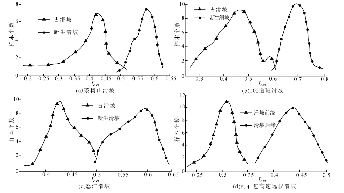
Fig.8 Statistical charts of pixel numbers of IGVI values of the ancient landslide and reactive landslide
| [1] | 崔鹏, 苏凤环, 邹强, 等. 青藏高原山地灾害和气象灾害风险评估与减灾对策[J]. 科学通报, 2015(32):3067-3077. |
| [2] | 张永双, 郭长宝, 姚鑫, 等. 青藏高原东缘活动断裂地质灾害效应研究[J]. 地球学报, 2016, 37(3):277-286. |
| [3] | 黄润秋. 20世纪以来中国的大型滑坡及其发生机制[J]. 岩石力学与工程学报, 2007, 26(3):433-454. |
| [4] |
XU Q, SHANG Y J, VAN Asch T, et al. Observations from the large, rapid Yigong rock slide-debris avalanche, southeast Tibet[J]. Canadian Geotechnical Journal, 2012, 49: 589-606.
DOI URL |
| [5] |
YIN Y P, XING A G. Aerodynamic modeling of the Yigong gigantic rock slide-debris avalanche, Tibet, China[J]. Bulletin of Engineering Geology and the Environment, 2011, 71: 149-160.
DOI URL |
| [6] | 殷跃平. 西藏波密易贡高速巨型滑坡概况[J]. 中国地质灾害与防治学报, 2000, 11(2):100. |
| [7] | 梁京涛, 成余粮, 王军, 等. 2013年7月10日四川省都江堰三溪村五里坡特大滑坡灾害遥感调查及成因机制浅析[J]. 工程地质学报, 2014, 22(6):1194-1203. |
| [8] | 许强, 李为乐. 汶川地震诱发大型滑坡分布规律研究[J]. 工程地质学报, 2010, 18(6):818-826. |
| [9] | 温铭生, 方志伟, 王阳谷. 都江堰市五里坡特大滑坡灾害特征与致灾成因[J]. 现代地质, 2015, 29(2):448-453. |
| [10] | 郭长宝, 杜宇本, 佟元清, 等. 青藏高原东缘理塘乱石包高速远程滑坡发育特征与形成机理[J]. 地质通报, 2016, 35(8):1332-1345. |
| [11] | 廖秋林, 李晓, 董艳辉, 等. 川藏公路林芝—八宿段地质灾害特征及形成机制初探[J]. 地质力学学报, 2004, 10(1):33-39. |
| [12] | 王治华. 大型个体滑坡遥感调查[J]. 地学前缘, 2006, 13(5):516-523. |
| [13] | 陈曦, 胥兵, 陈爱明, 等. 遥感技术在提取滑坡背景环境因素的应用——以湖北省房县地区滑坡地质灾害为例[J]. 资源环境与工程, 2014(6):950-959. |
| [14] | 石菊松, 吴树仁, 石玲. 遥感在滑坡灾害研究中的应用进展[J]. 地质论评, 2008, 54(4):505-514. |
| [15] | 张雪峰, 何政伟, 薛东剑, 等. 汶川地震大型单体滑坡遥感调查与危险性评价[J]. 遥感信息, 2011(3):50-54. |
| [16] | 徐宜保. 二滩水电站库区滑坡的航片判读[J]. 水力发电, 1987(10):29-33. |
| [17] | 殷志强, 秦小光, 赵无忌, 等. 基于多元遥感影像数据的黄河上游滑坡发育特征研究[J]. 工程地质学报, 2013, 21(5):779-787. |
| [18] | 邓辉. 高精度卫星遥感技术在地质灾害调查与评价中的应用[D]. 成都: 成都理工大学, 2007. |
| [19] | 童立强, 郭兆成. 典型滑坡遥感影像特征研究[J]. 国土资源遥感, 2013, 25(1):86-92. |
| [20] | 刘凤山, 吴中海, 张岳桥, 等. 青藏高原东缘新构造与活动构造研究新进展及展望[J]. 地质通报, 2014, 33(4):403-418. |
| [21] | ACHACHE J, FRUNEAU B, DELACOURT C. Applicability of SAR interferometry for monitoring of landslides[J]. Ers Applications, 1996, 383:165. |
| [22] | 张洁, 胡光道, 罗宁波. INSAR技术在滑坡监测中的应用研究[J]. 工程地球物理学报, 2004, 1(2):147-153. |
| [23] | MOLLARD J D. Regional Landslide Types in Canada.[M]. Colorado: The Geological Society of America, 1962:1-10. |
| [24] | 韩岭, 苗放, 刘学工, 等. 基于高清遥感影像的滑坡自动解译方法探索[J]. 人民黄河, 2010, 32(12):33-34. |
| [25] | 吴忠芳. RS和GIS技术支持下的武隆县大型滑坡遥感解译及其危险性评价[D]. 重庆: 西南大学, 2009. |
| [26] | 丁辉, 张茂省, 李林. 基于多特征面向对象区域滑坡现象识别[J]. 遥感技术与应用, 2013, 28(6):1107-1113. |
| [27] | 鲁学军, 史振春, 尚伟涛, 等. 滑坡高分辨率遥感多维解译方法及其应用[J]. 中国图象图形学报, 2014, 19(1):141-149. |
| [28] | 杨文涛, 汪明, 史培军, 等. 基于地形因子分割、分类的面向对象滑坡快速识别方法[J]. 自然灾害学报, 2015(4):1-6. |
| [29] |
MARTHA T R, KERLE N, JETTEN V, et al. Characterizing spectral, spatial and morphometric properties of landslides for semi-automatic detection using object-oriented methods[J]. Geomorphology, 2010, 116(1/2):24-36.
DOI URL |
| [30] | BAATZ M, SCHAPE M. Multiresolution segmentation-An optimization approach for high quality multi-scale image segmentation[M]// STROBLJ, BLASCHKET, GRIESEBNERG. Angewandte Geographische Informations-Verarbeitung XII. Karlsruhe: Wichmann Verlag, 2000:12-23. |
| [31] | LAHOUSSE T, CHANG K T, LIN Y H. Landslide mapping with multi-scale object-based image analysis:a case study in the Baichi watershed, Taiwan[J]. Natural Hazards & Earth System Sciences, 2011, 11(10):2715-2726. |
| [32] |
FRANKLIN S E. Classification of soil-and bedrock-dominated landslides in British Columbia using segmentation of satellite imagery and DEM data[J]. International Journal of Remote Sensing, 2005, 26(7):1505-1509.
DOI URL |
| [33] | 胡德勇, 李京, 赵文吉, 等. 基于对象的高分辨率遥感图像滑坡检测方法[J]. 自然灾害学报, 2008, 17(6):42-46. |
| [34] | 王岩, 王晓青, 窦爱霞. 面向对象遥感分类方法在汶川地震震害提取中的应用[J]. 地震, 2009, 29(3):54-60. |
| [35] | 明冬萍, 骆剑承, 沈占锋, 等. 高分辨率遥感影像信息提取与目标识别技术研究[J]. 测绘科学, 2005, 30(3):18-20. |
| [36] | 曹宝, 秦其明, 马海建, 等. 面向对象方法在SPOT5遥感图像分类中的应用——以北京市海淀区为例[J]. 地理与地理信息科学, 2006, 22(2):46-49. |
| [37] | 王赛. 基于多源遥感数据的汶川地震型滑坡信息提取研究[D]. 北京: 中国地质大学(北京), 2015. |
| [38] |
LAINE A, FAN J. Frame representations for texture segmentation[J]. IEEE Transactions on Image Processing: A Publication of the IEEE Signal Processing Society, 1996, 5(5):771-780.
DOI URL |
| [39] | GORTE B. Probabilistic segmentation of remotely sensed images[D]. Wageningen: Wageningen Agricultural University, 1998. |
| [40] | 易文斌, 唐宏, 杨晋科. 面向对象的灾害信息遥感提取框架及其应用[J]. 自然灾害学报, 2009, 18(5):157-162. |
| [41] | BAATZ M, SCHAPE A, SCHMIDT G, et al. Cognition Network Technology: Object orientation and fractal topology in biomedical image analysis[M]. Birkhauser Basel: Method and Applications, 2005:67-73. |
| [42] | 张毅, 谭龙, 陈冠, 等. 基于面向对象分类法的高分辨率遥感滑坡信息提取[J]. 兰州大学学报(自然科学版), 2014(5):745-750. |
| [43] | 白永健, 郑万模, 李明辉, 等. 川藏公路茶树山滑坡特征及成因机制分析[J]. 工程地质学报, 2010, 18(6):862-866. |
| [44] | 龙维, 陈剑, 王鹏飞, 等. 金沙江上游特米大型古滑坡的成因及古地震参数反分析[J]. 地震研究, 2015, 38(4):568-575. |
| [45] | 张晓刚, 王成华, 孔纪名, 等. 川藏公路“102”滑坡群的基本特征[J]. 山地学报, 1998, 16(2):151-155. |
| [46] | 何兵, 张小刚. 川藏公路102滑坡遥感调查及发展趋势分析[J]. 中国地质灾害与防治学报, 2015, 26(4):99-105. |
| [47] | 李同录, 赵剑丽, 李萍. 川藏公路102滑坡群2#滑坡发育特征及稳定性分析[J]. 灾害学, 2003, 18(4):40-45. |
| [48] | 杨全忠. 西藏滑坡地质灾害及防治对策[J]. 中国地质灾害与防治学报, 2002, 13(1):94-97. |
| [1] | LI Junlei, ZHANG Xujiao, WANG Yifan, ZHANG Xiangge, WANG Chongge, YUAN Xiaoning, LIU Xinlan, WANG Kaiya, RAO Haoshu, LIU Jiang, QIN Yuan. Route Planning and Ponder of Geoscience Study Travel in Hualong County, Qinghai Province [J]. Geoscience, 2023, 37(05): 1411-1422. |
| [2] | LIU Xinlan, ZHANG Xujiao, LI Junlei, WANG Yifan, ZHANG Xiangge, YUAN Xiaoning, WANG Kaiya, WANG Chongge, LIU Jiang, HOU Engang. Characteristics and Scientific Values of “Canyon and Danxia” Landform in Hualong County, Qinghai Province [J]. Geoscience, 2023, 37(01): 233-244. |
| [3] | HU Mengjun, JI Tianqi, ZHENG Dengyou, ZHUANG Jing, SUN Wenli, XU Aokang. Variation Characteristics of Chromatic Parameters of Eolian Sediments and Environmental Evolution on the Northeastern Tibetan Plateau Since 9.4 ka [J]. Geoscience, 2022, 36(02): 439-448. |
| [4] | CHEN Jing, LI Dapeng, KANG Huan, GENG Jianzhen, ZHANG Jingjing. Provenances and Tectonic Significance of Detrital Zircons from the Triassic to Jurassic Sedimentary Rocks in the Diancangshan Metamorphic Massif, Western Yunnan Province [J]. Geoscience, 2021, 35(04): 883-913. |
| [5] | LI Xue, GUO Changbao, YANG Zhihua, LIAO Wei, WU Ruian, JIN Jijun, HE Yuanxiao. Development Characteristics and Formation Mechanism of the Xiongba Giant Ancient Landslide in the Jinshajiang Tectonic Zone [J]. Geoscience, 2021, 35(01): 47-55. |
| [6] | MENG Wen, GUO Changbao, MAO Bangyan, LU Haifeng, CHEN Qunce, XU Xueyuan. Tectonic Stress Field and Engineering Influence of China-Nepal Railway Corridor [J]. Geoscience, 2021, 35(01): 167-179. |
| [7] | ZHAO Yuanfang, GONG Wangbin, JIANG Wan, CHEN Longyao, QIU Duwei. Multi-stage Characteristics and Tectonic Significance of the Jiali Fault in Guxiang-Tongmai Section, South Tibet [J]. Geoscience, 2021, 35(01): 220-233. |
| [8] | XIA Mengmeng, GAO Wanli, HU Daogong, ZHANG Yaoling, XU Jiusheng, JIA Liyun, WANG Chaoqun. Zircon U-Pb Ages for Volcanic Rocks in Bayan Har Group in the Northern Tibetan Plateau and Its Geological Significance [J]. Geoscience, 2019, 33(05): 957-969. |
| [9] | LI Langping, LAN Hengxing, GUO Changbao, ZHANG Yongshuang, LI Quanwen, WU Yuming. Geohazard Susceptibility Assessment Along the Sichuan-Tibet Railway and Its Adjacent Area Using an Improved Frequency Ratio Method [J]. Geoscience, 2017, 31(05): 911-929. |
| [10] | KANG Huan1, LI Dapeng1,2, CHEN Yuelong1, LU Zhen1. Origin and Tectonic Implications of the Early Paleozoic HighSi Granite in the Eastern Baoshan Block, Yunnan [J]. Geoscience, 2016, 30(5): 1026-1037. |
| [11] | . Landslide Susceptibility Evaluation Based on Weight-of-Evidence Modeling in the Xianshuihe Fault Zone, East Tibetan Plateau [J]. Geoscience, 2016, 30(3): 705-715. |
| [12] | ZHAO Qiu-chen,ZHANG Xu-jiao,HE Ze-xin,HE Xiang-li,WANG Jian-yong,FU Lian-zhen,JI. Age of Upper Jinghe River Terraces at the Eastern Piedmont of Liupanshan and Its Significance for Neotectonic Movement [J]. Geoscience, 2014, 28(6): 1202-1212. |
| [13] | YANG Deshou1, GONG Jianming2, HE Xingliang2, WANG Huidong1,. Discussion about the CO2 Origins of Wuli Permafrost Zone in QinghaiTibetan Plateau [J]. Geoscience, 2013, 27(6): 1392-1398. |
| [14] | LI Xiaoyu1, GONG Jianming2, CHEN Xiaohui3, WANG Huidong1,. Source Rock Potential of Permian in Wuli Permafrost Zone in QinghaiTibetan Plateau [J]. Geoscience, 2013, 27(6): 1384-1391. |
| [15] | XIE Wei, SUN Tian-He, HAN Feng, YUAN Guo-Li. Polybrominated Diphenyl Ethers (PBDEs) in Surface Soil from Central Tibetan Plateau, China: CongenersDistribution and Controlling Factors [J]. Geoscience, 2012, 26(5): 917-925. |
| Viewed | ||||||
|
Full text |
|
|||||
|
Abstract |
|
|||||