

Geoscience ›› 2022, Vol. 36 ›› Issue (04): 1105-1117.DOI: 10.19657/j.geoscience.1000-8527.2022.196
• Oil and Gas Exploration • Previous Articles Next Articles
FAN Yan1( ), WANG Xulong2, XIANG Caifu1(), WANG Qianjun3, LIU Jia1, LIAO Jiande2, XU Huaimin1
Received:2021-01-15
Revised:2022-02-05
Online:2022-08-10
Published:2022-09-09
Contact:
XIANG Caifu
CLC Number:
FAN Yan, WANG Xulong, XIANG Caifu, WANG Qianjun, LIU Jia, LIAO Jiande, XU Huaimin. Enrichment Patterns and Main Controlling Factors of Source Rocks in the Permian Pingdiquan Formation, Eastern Junggar Basin[J]. Geoscience, 2022, 36(04): 1105-1117.
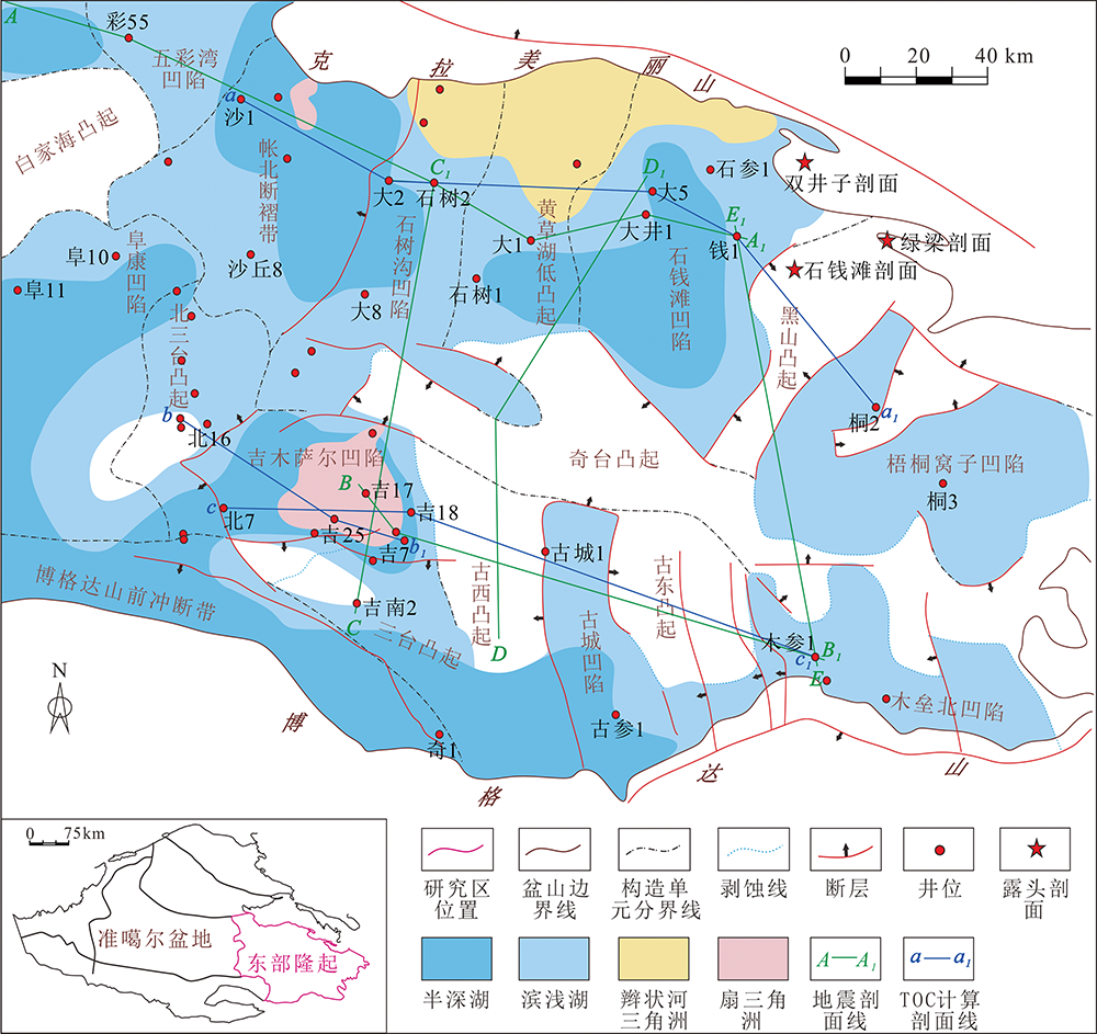
Fig.1 Tectonic divisions and Middle Permian sedimentary facies in the eastern Junggar Basin
| 区带 | 有机质丰度 | 有机质 类型 | 有机质成熟度 | 暗色泥岩厚度 | ||||||
|---|---|---|---|---|---|---|---|---|---|---|
| 位置 | 凹陷 | TOC/% | 平均值/% | Ro/%或Tmax/℃ | 平均值/%或℃ | 分布区间/m | 平均值/m | |||
| 克拉美丽 山前带 | 帐北断褶带- 北三台凸起 | 0.1~71.4 (n=263) | 4.0 | Ⅰ-Ⅱ2 | 0.6%~1.3% (n=15) | 0.8% | 10~230 | 200 | ||
| 石钱滩 | 0.1~4.9 (n=18) | 0.7 | Ⅱ1-Ⅲ | 365~487 ℃ (n=18) | 460.9 ℃ | 50~170 | 100 | |||
| 露头剖面 | 0.1~3.6 (n=13) | 0.9 | / | 420~523 ℃ (n=13) | 472 ℃ | / | / | |||
| 博格达 山前带 | 阜康 | 0.5~2.6 (n=16) | 1.1 | Ⅱ1-Ⅲ | 1.5% (n=2) | 1.5% | 50~200 | 150 | ||
| 吉木萨尔 | 2.2~9.6[ (n=76) | 6.7 | Ⅰ-Ⅱ2 | 0.5%~2.1%[ (n=35) | 0.8% | 50~170 | 100 | |||
| 木垒北 | 0.1~1.7 (n=34) | 0.8 | Ⅰ-Ⅱ1 | 0.8%~1.1% (n=9) | 0.8% | 50~250 | 150 | |||
Table 1 Source rock characteristics of the Pingdiquan Formation in the eastern Junggar Basin
| 区带 | 有机质丰度 | 有机质 类型 | 有机质成熟度 | 暗色泥岩厚度 | ||||||
|---|---|---|---|---|---|---|---|---|---|---|
| 位置 | 凹陷 | TOC/% | 平均值/% | Ro/%或Tmax/℃ | 平均值/%或℃ | 分布区间/m | 平均值/m | |||
| 克拉美丽 山前带 | 帐北断褶带- 北三台凸起 | 0.1~71.4 (n=263) | 4.0 | Ⅰ-Ⅱ2 | 0.6%~1.3% (n=15) | 0.8% | 10~230 | 200 | ||
| 石钱滩 | 0.1~4.9 (n=18) | 0.7 | Ⅱ1-Ⅲ | 365~487 ℃ (n=18) | 460.9 ℃ | 50~170 | 100 | |||
| 露头剖面 | 0.1~3.6 (n=13) | 0.9 | / | 420~523 ℃ (n=13) | 472 ℃ | / | / | |||
| 博格达 山前带 | 阜康 | 0.5~2.6 (n=16) | 1.1 | Ⅱ1-Ⅲ | 1.5% (n=2) | 1.5% | 50~200 | 150 | ||
| 吉木萨尔 | 2.2~9.6[ (n=76) | 6.7 | Ⅰ-Ⅱ2 | 0.5%~2.1%[ (n=35) | 0.8% | 50~170 | 100 | |||
| 木垒北 | 0.1~1.7 (n=34) | 0.8 | Ⅰ-Ⅱ1 | 0.8%~1.1% (n=9) | 0.8% | 50~250 | 150 | |||
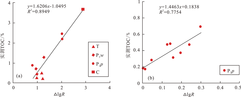
Fig.2 Logging prediction model of organic matter abundance in the Pingdiquan Formation, eastern Junggar Basin
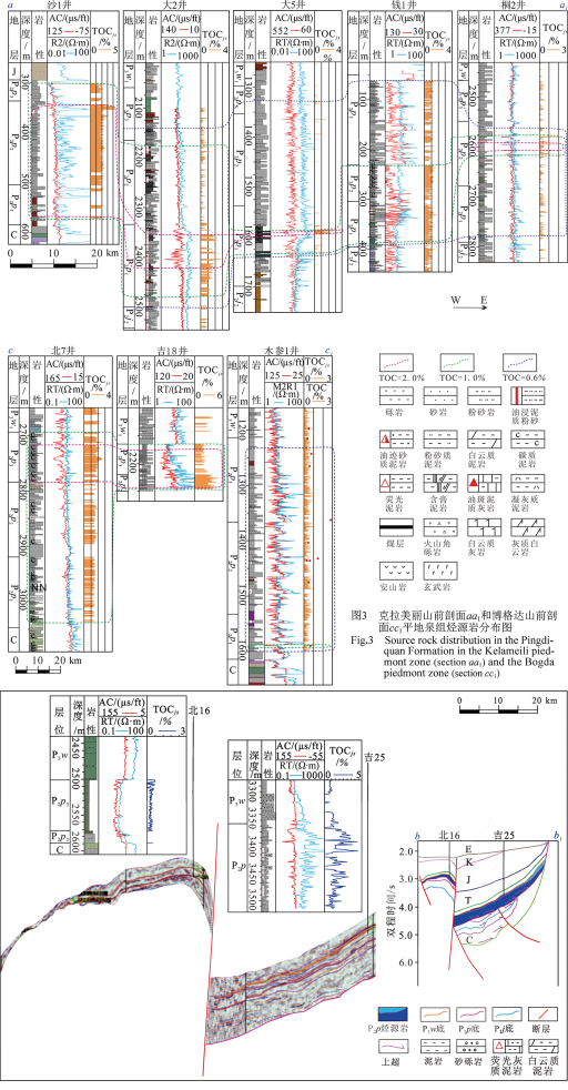
Fig.4 Schematic seismic facies prediction method for the spatial distribution of high abundance source rocks, eastern Junggar Basin
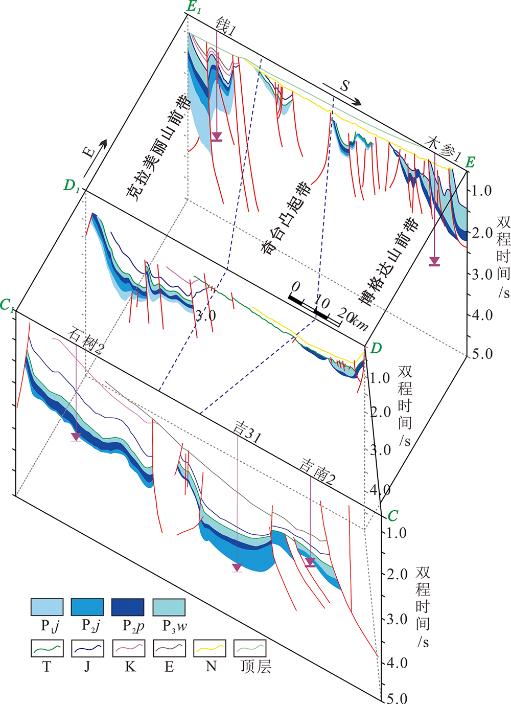
Fig.5 Source rock characteristics of the Pingdiquan Formation in the north-south section, eastern Junggar Basin
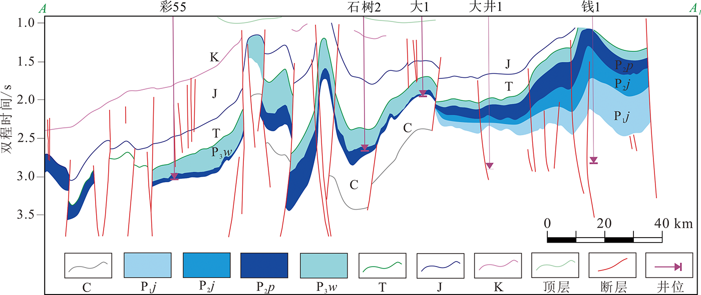
Fig.6 Source rock characteristics of the Pingdiquan Formation in Section AA1, eastern Junggar Basin
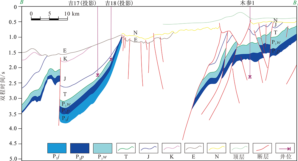
Fig.7 Source rock characteristics of the Pingdiquan Formation in Section BB1, eastern Junggar Basin

Fig.8 Intersection diagram of organic carbon content and hydrocarbon generation potential, and the contour map of TOC in the Pingdiquan Formation of different sags, eastern Junggar Basin
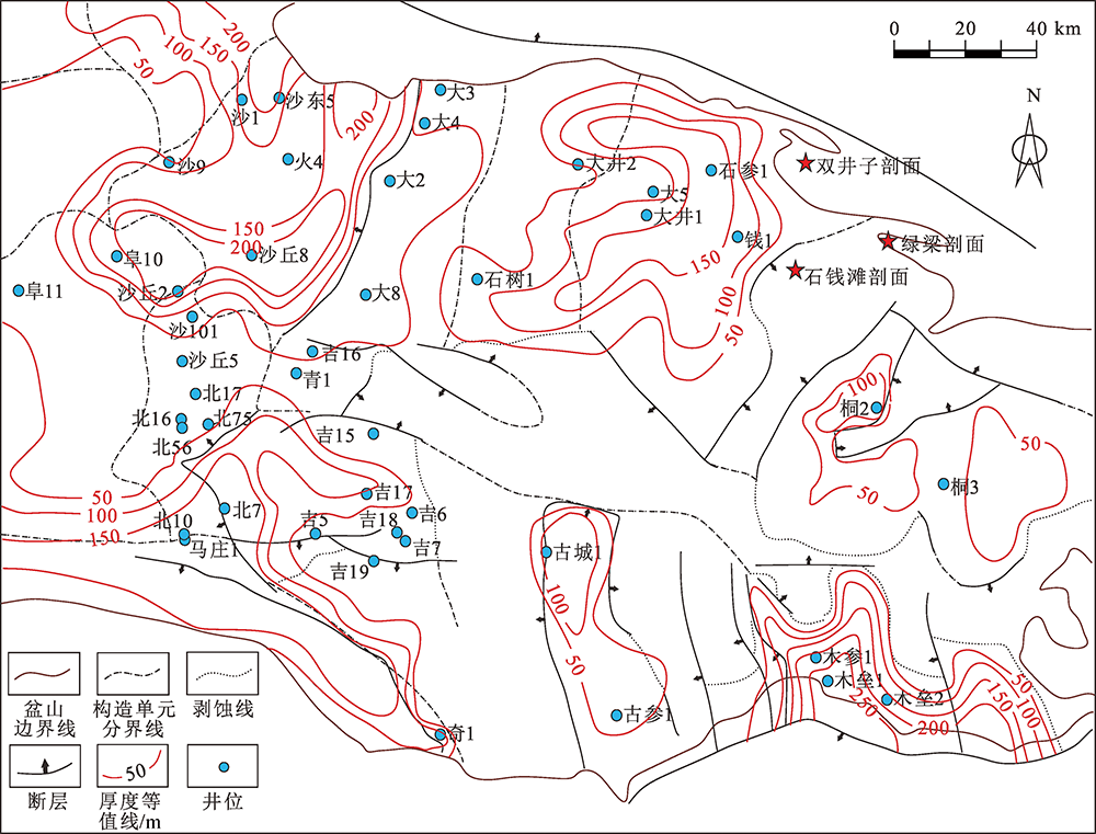
Fig.9 Isopach map of source rocks in the Pingdiquan Formation, eastern Junggar Basin
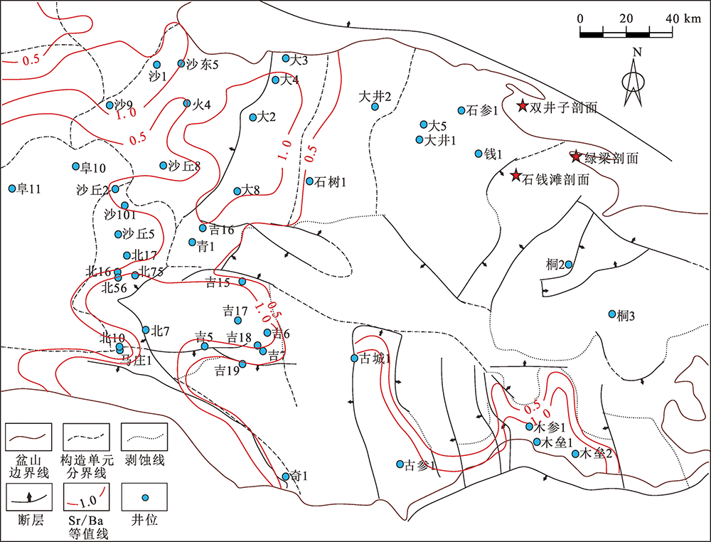
Fig.10 Sr/Ba contour map of source rocks in the Pingdiquan Formation, eastern Junggar Basin
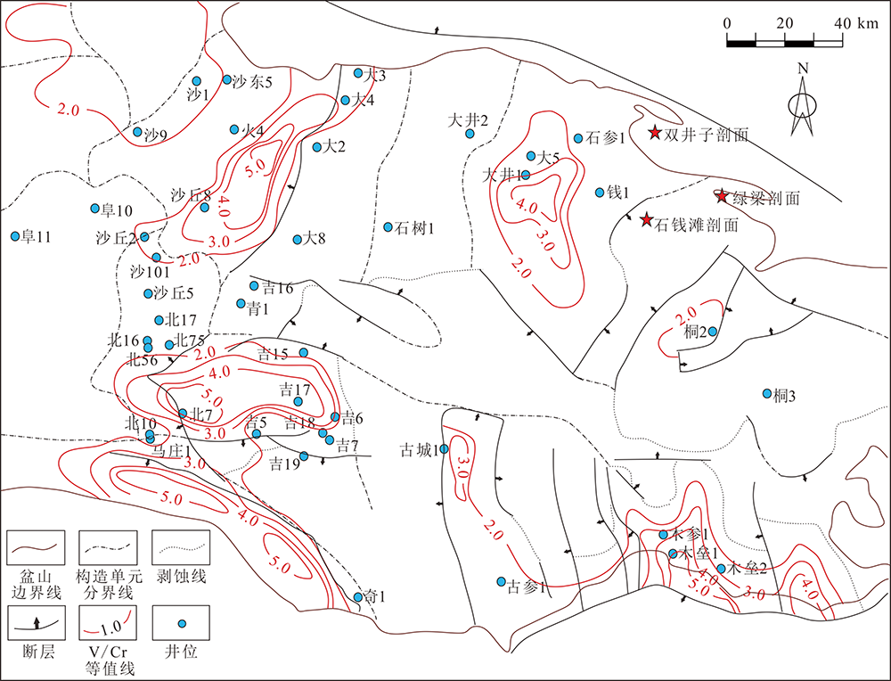
Fig.11 V/Cr contour map of source rocks in the Pingdiquan Formation, eastern Junggar Basin
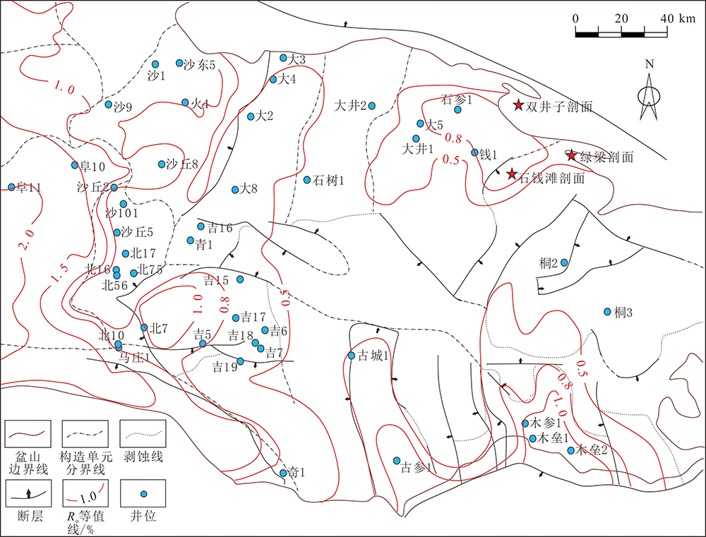
Fig.12 Maturity contour map of source rocks in the Pingdiquan Formation, eastern Junggar Basin
| [1] | 方世虎, 徐怀民, 宋岩, 等. 准噶尔盆地东部吉木萨尔凹陷复合含油气系统特征及其演化[J]. 地球学报, 2005, 26(3):259-264. |
| [2] | 刘俊榜, 刘震, 景晓凤, 等. 利用测井曲线反演计算烃源岩有机碳质量分数--以准噶尔盆地东部为例[J]. 石油天然气学报, 2013, 35 (5):28-32. |
| [3] | 匡立春, 唐勇, 雷德文, 等. 准噶尔盆地二叠系咸化湖相云质岩致密油形成条件与勘探潜力[J]. 石油勘探与开发, 2012, 39 (6):657-667. |
| [4] | 曲江秀, 艾热提·吾甫尔, 查明, 等. 准噶尔盆地吉木萨尔凹陷芦草沟组致密油形成条件与分布规律[J]. 现代地质, 2017, 31(1):119-128. |
| [5] | 操应长, 朱宁, 张少敏, 等. 准噶尔盆地吉木萨尔凹陷二叠系芦草沟组致密油储层成岩作用与储集空间特征[J]. 地球科学与环境学报, 2019, 41(3):253-266. |
| [6] | 蒋中发, 丁修建, 王忠泉, 等. 吉木萨尔凹陷二叠系芦草沟组烃源岩沉积古环境[J]. 岩性油气藏, 2021, 33(2):2-9. |
| [7] | 李博一, 刘洛夫, 卫倩倩, 等. 彩南探区二叠系平地泉组烃源岩展布与潜力评价[J]. 科学技术与工程, 2014, 14(24):195-202. |
| [8] | 袁波, 王心强, 路俊刚, 等. 准东北部平地泉组致密油源岩生烃特征[J]. 石油实验地质, 2014, 36(6):744-751. |
| [9] | 吕铁良, 张奎华, 林畅松, 等. 准噶尔盆地木垒凹陷油气来源及成藏特征[J]. 东北石油大学学报, 2016, 40(5):1-9. |
| [10] | 赵玉峰. 准噶尔盆地东缘木垒凹陷二叠系平地泉组烃源岩特征分析[J]. 华北自然资源, 2019(1):58-66. |
| [11] | 胡自龙, 卞保力, 刘海磊, 等. 准噶尔盆地大井地区天然气成因、来源与成藏过程[J]. 天然气地球科学, 2019, 30(6):850-859. |
| [12] | 郑孟林, 田爱军, 杨彤远, 等. 准噶尔盆地东部地区构造演化与油气聚集[J]. 石油与天然气地质, 2018, 39(5):907-917. |
| [13] | 李锦轶. 试论新疆东准噶尔早古生代岩石圈板块构造演化[J]. 中国地质科学院院报, 1991, 23:1-11. |
| [14] | 顾连兴, 胡受奚, 于春水, 等. 东天山博格达造山带石炭纪火山岩及其形成地质环境[J]. 岩石学报, 2000(3):305-316. |
| [15] |
XIAO W J, HUANG B C, HAN C M, et al. A review of the western part of the Altaids:a key to understanding the architecture of accretionary orogens[J]. Gondwana Research, 2010, 18:253-273.
DOI URL |
| [16] |
XIAO W J, WINDLEY B F, YUAN C, et al. Paleozoic multiple subduction-accretion processes of the southern Altaids[J]. American Journal of Science, 2009, 309(3):221-270.
DOI URL |
| [17] | 徐学义, 马中平, 夏林折, 等. 北天山巴音沟蛇绿岩斜长花岗岩错石SHRIMP测年及其意义[J]. 地质论评, 2005, 51(5):524-527. |
| [18] | 韩宝福, 季建清, 宋彪, 等. 新疆准噶尔晚古生代陆壳垂向生长(Ⅰ)--后碰撞深成岩浆活动的时限[J]. 岩石学报, 2006(5):1077-1086. |
| [19] | LI D, HE D F, SANTOSH M, et al. Petrogenesis of Late Paleozoic volcanics from the Zhaheba depression,East Junggar:Insights into collisional event in an accretionary orogen of Central Asia[J]. Lithos, 2014:167-193. |
| [20] | 宋利宏, 朱光, 顾承串, 等. 卡拉麦里断裂带造山期活动规律及其对造山过程的指示[J]. 地质论评, 2015, 61(1):79-94. |
| [21] | 易泽军. 准噶尔盆地东部二叠系地质结构及成因机制[D]. 北京: 中国地质大学(北京), 2018:63-138. |
| [22] | 王绪龙, 廖建德, 向才富, 等. 新疆油田分公司准噶尔盆地东部地区勘探成果报告[R]. 克拉玛依市: 新疆油田分公司勘探开发研究院, 2018. |
| [23] | 张义杰, 齐雪峰, 程显胜, 等. 准噶尔盆地晚石炭世和二叠纪沉积环境[J]. 新疆石油地质, 2007(6):673-675. |
| [24] | 康志宏. 准噶尔盆地古生代沉积演化特征[J]. 地质力学学报, 2011, 17(2):158-174. |
| [25] | 巩书华, 周世新, 李靖, 等. 准噶尔盆地石炭系与二叠系主力烃源岩地球化学特征对比研究[J]. 天然气地球科学, 2013, 24(5):1005-1015. |
| [26] | 李锋, 杜小弟, 徐银波, 等. 准东地区二叠系芦草沟组发育期古环境特点恢复的地球化学记录[J]. 石油地质与工程, 2016, 30(2):12-16. |
| [27] |
郑孟林, 樊向东, 何文军, 等. 准噶尔盆地深层地质结构叠加演变与油气赋存[J]. 地学前缘, 2019, 26(1):22-32.
DOI |
| [28] | 王子萌. 吉木萨尔凹陷芦草沟组烃源岩特征及形成机制研究[D]. 青岛: 中国石油大学(华东), 2018:13-14. |
| [29] | CREANEYS R P Q. A practical model for organive richness from porosity and resistivity logs[J]. AAPG Bulletin, 1990, 74(12):1777-1794. |
| [30] | 顾礼敬, 徐守余, 苏劲, 等. 利用地震资料预测和评价烃源岩[J]. 天然气地球科学, 2011, 22(3):555-557. |
| [31] | 张寒, 朱光有. 利用地震和测井信息预测和评价烃源岩--以渤海湾盆地富油凹陷为例[J]. 石油勘探与开发, 2007(1):55-59. |
| [32] |
HAN Y, ZHAO G. Final amalgamation of the Tianshan and Junggar orogenic collage in the southwestern Central Asian Orogenic Belt:Constraints on the closure of the Paleo-Asian Ocean[J]. Earth-Science Reviews, 2018, 186:129-152.
DOI URL |
| [33] |
SAFONOVA I, KOTLYAROV A, KRIVONOGOV S, et al. Intra-oceanic arcs of the Paleo-Asian Ocean[J]. Gondwana Research, 2017, 50:167-194.
DOI URL |
| [34] | 卢苗安. 天山东段盆山构造格局的多期演变[D]. 北京: 中国地震局地质研究所, 2007:105-132. |
| [35] | PIETRAS J T, RHODES M K, WARTES M A, et al. Stromtium isotopes in provenance studies of large ancient lacustrine basins:an example from the Junggar-Turpan-Hami basins,NW China[J]. Geological Society of America Abstracts with Programs, 1999, 31(7):298. |
| [36] | 经雅丽, 张克信, 林启祥, 等. 浙江长兴煤山下三叠统和龙山组、南陵湖组沉积地球化学特征与古环境意义[J]. 地质科技情报, 2005(1):35-40. |
| [37] |
JONES B, MANNING D A C. Comparison of geochemical indices used for the interpretation of palaeoredox conditions in ancient mud-stones[J]. Chemical Geology, 1994, 111(1/4):111-129.
DOI URL |
| [38] |
李艳芳, 邵德勇, 吕海刚, 等. 四川盆地五峰组-龙马溪组海相页岩元素地球化学特征与有机质富集的关系[J]. 石油学报, 2015, 36(12):1470-1483.
DOI |
| [1] | KE Xing, ZHAO Qingfang, WU Piao, YANG Chuansheng, LIAO Jing, GONG Jianming. Characteristics and Evaluation of Cretaceous Source Rocks in the Northeastern Jiaolai Basin [J]. Geoscience, 2023, 37(05): 1358-1368. |
| [2] | YANG Xiongbing, WANG Hongyu, SU Yushan, GUAN Chao. Source Rock Characteristics and Its Accumulation Contribution in the Lower Congo Basin, South Atlantic [J]. Geoscience, 2023, 37(05): 1369-1384. |
| [3] | GAN Jun, JI Hongquan, LIANG Gang, HE Xiaohu, XIONG Xiaofeng, LI Xing. Gas Accumulation Model of Mesozoic Buried Hill in Qiongdongnan Basin [J]. Geoscience, 2022, 36(05): 1242-1253. |
| [4] | ZHANG Yingzhao, HU Senqing, LIU Jinshui, JIANG Yiming, CHEN Zhongyun, QIN Jun, DIAO Hui, WANG Chao. Geochemical Characteristics and Genesis of Oil and Gas in the Lishuixi Sag, East China Sea Shelf Basin [J]. Geoscience, 2022, 36(05): 1382-1390. |
| [5] | ZHENG Qinghua, LIU Xingjun, ZHANG Xiaolong, WANG Hongjun, LIAO Yongle, AN Erliang, LIU Tao, ZHANG Jianna, ZUO Qin. Review of the High Natural Gamma Sandstones Associated With Source Rocks in the Chang 73 Submember of the Yanchang Formation, Ordos Basin [J]. Geoscience, 2022, 36(04): 1087-1094. |
| [6] | GAO Yangdong, LIN Heming, WANG Xudong, QIU Xinwei, QUE Xiaoming, LI Min, ZHAO Zeying, CHEN Yan. Geochemical Constraints on the Sedimentary Environment of Wenchang Formation in Pearl River Mouth Basin and Its Paleoenvironmental Implications [J]. Geoscience, 2022, 36(01): 118-129. |
| [7] | LI Yan, DENG Yunhua, LI Youchuan. Characteristics and Mechanism of Source Rock Development Controlled by Sedimentary Microfacies in River-delta System: Case Study of Coal-measure Source Rock in Enping Formation in Pearl River Estuary Basin [J]. Geoscience, 2021, 35(04): 1065-1077. |
| [8] | QI Peng, GUO Gang, REN Yaping, CUI Min, WANG Xin. Geological Characterization of the Eocene Pinghu Movement in the Xihu Sag and Its Hydrocarbon Geological Significance [J]. Geoscience, 2021, 35(04): 1098-1105. |
| [9] | SHEN Hua, LIU Zhen, SHI Yuanpeng, XU Zeyang, LI Yongjun, CHEN Shuguang, WANG Huilai, WANG Zhicheng, WANG Biao, LIU Chang. Hydrocarbon Accumulation Process and Exploration Potential in Linhe Depression, Hetao Basin [J]. Geoscience, 2021, 35(03): 871-882. |
| [10] | JIANG Wei, GAO Zhiqian, HU Zongquan, ZHAO Yongqiang, CHU Chenglin. Sedimentary Filling Evolution and Hydrocarbon Control of High Frequency Sequence in Yurtus Formation, Tarim Basin [J]. Geoscience, 2021, 35(02): 349-364. |
| [11] | ZHAO Yande, DENG Xiuqing, QI Yalin, SHAO Xiaozhou, YANG Bin, LU Xinchuan, LUO Anxian, XIE Xiankui. Geochemical Characteristics of Source Rocks of M53 Well and Chang-8 Member Oil-source in Pingliangbei Exploration Area, Ordos Basin [J]. Geoscience, 2020, 34(04): 800-811. |
| [12] | ZHANG He, JIANG Zhenglong, LI Yajun, LIANG Shuang, FU Wenkai. Hydrocarbon Generation Conditions and Regional Comparison of the Lower Jurassic Kangsu Formation in Washixia Sag, Tarim Basin [J]. Geoscience, 2019, 33(06): 1241-1251. |
| [13] | QI Yulin, ZHANG Zhihuan, XIA Dongling, ZHANG Huimin, HUANG Caixia, ZHENG Duo, JIN Xiao, CAO Yongle, ZHU Lei. Comparative Analysis of Hydrocarbon Generation Kinetics of Dark Shale and Black Shale of Chang 7 in Southern Ordos Basin [J]. Geoscience, 2019, 33(04): 863-871. |
| [14] | XI Shengli, GANG Wenzhe, YANG Qingyu, CHEN Guo, LIU Yazhou, WANG Ning, LIU Lan. Organic Geochemistry and Sedimentary Paleoenvironment of Chang 7 Source Rocks in Yanchi-Dingbian Area, Ordos Basin [J]. Geoscience, 2019, 33(04): 890-901. |
| [15] | LI Lei, LI Sumei, ZHANG Hongan, XU Tianwu, ZHANG Yunxian, JI Hong. Characteristics and Formation Mechanisms for the Saline Lacustrine Oil in the West Slope of the Dongpu Sag [J]. Geoscience, 2018, 32(06): 1109-1124. |
| Viewed | ||||||
|
Full text |
|
|||||
|
Abstract |
|
|||||