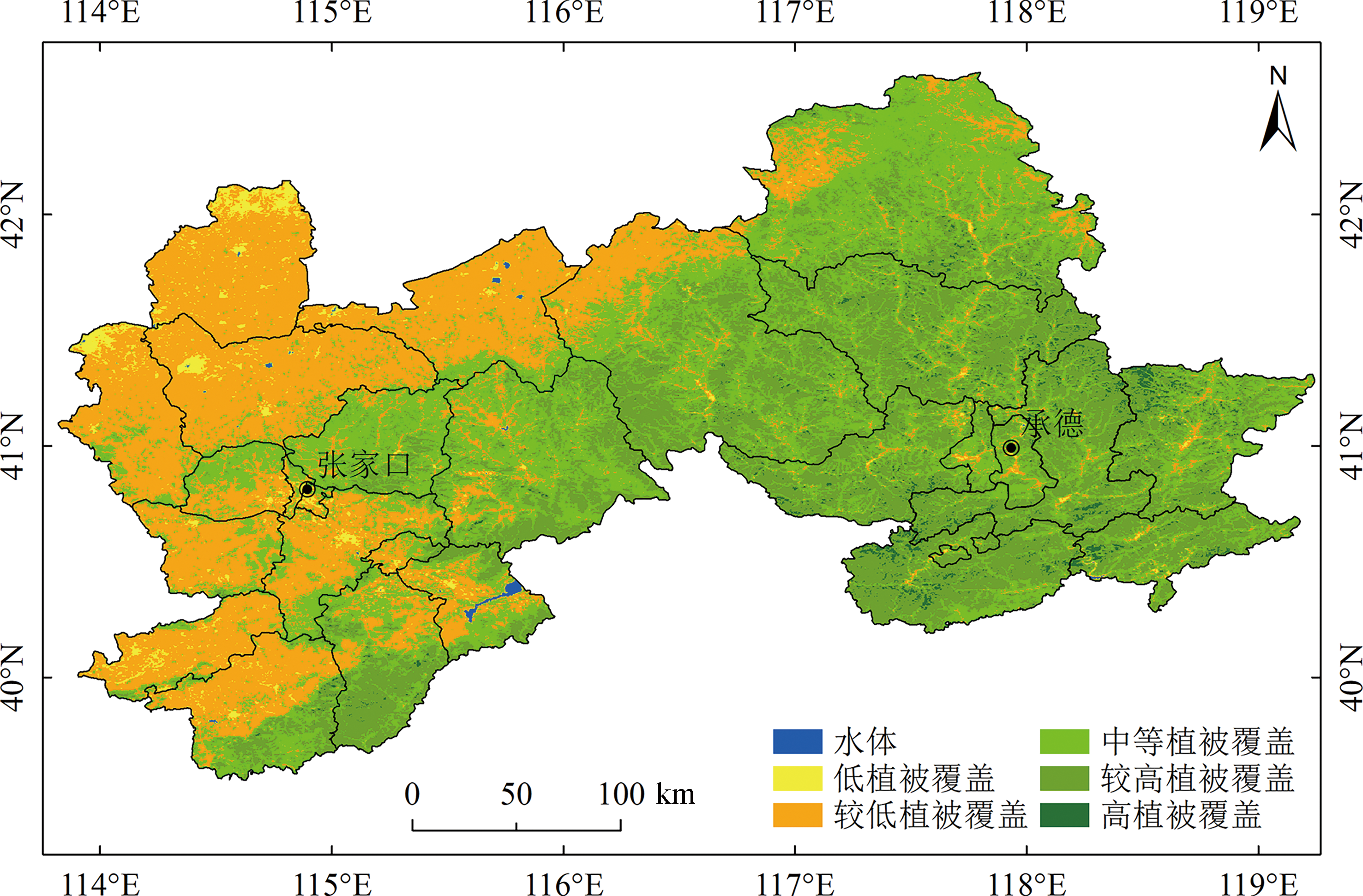
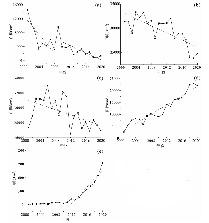
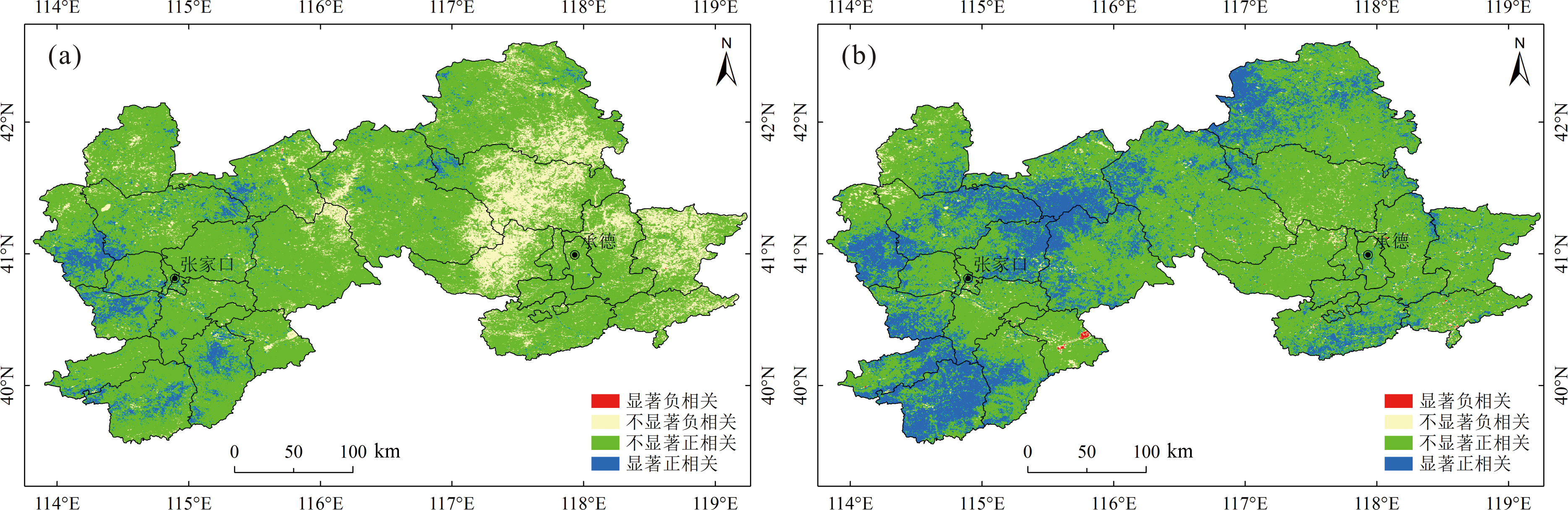
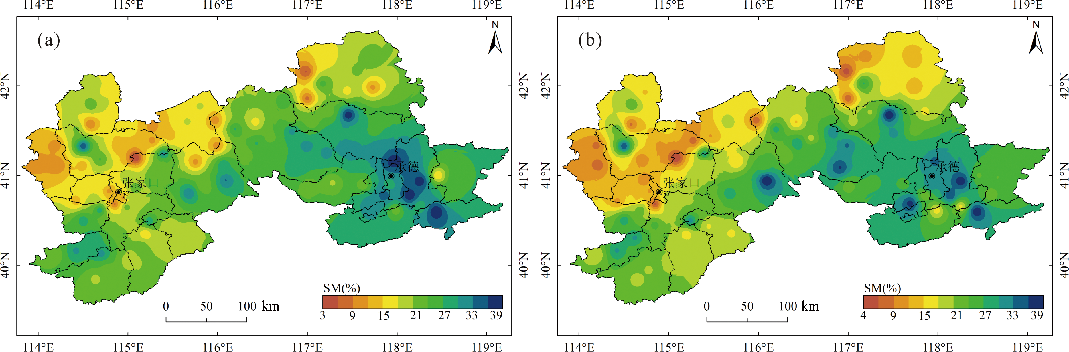
| [1] |
邵雅琪, 姜群鸥, 胡中民, 等. 张承地区植被指数时空演变特征及其与气候因子的关系[J]. 中国农业大学学报, 2018, 23(7): 96-106.
|
| [2] |
钞振华, 张培栋, 袁赛帅. 山东省MODIS遥感植被指数时空变化研究[J]. 生态环境学报, 2012, 21(10): 1660-1664.
DOI
|
| [3] |
蔺星娜, 牛健植, 贾京伟, 等. 张家口清水河上游流域植被指数时空变化特征[J]. 中国水土保持科学, 2018, 16(1): 123-130.
|
| [4] |
崔浩楠, 罗海江, 张学珍. 1982—2019年长江经济带植被覆盖变化的时空特征[J]. 生态学杂志, 2021, 40(8): 2517-2529.
|
| [5] |
DETSCH F, OTTE I, APPELHANS T, et al. Seasonal and long-term vegetation dynamics from 1-km GIMMS-based NDVI time series at Mt. Kilimanjaro, Tanzania[J]. Remote Sensing of Environment, 2016, 178: 70-83.
DOI
URL
|
| [6] |
CHERNETSKIY M, PASKO I, SHEVYRNOGOV A, et al. A study of forest vegetation dynamics in the south of the Krasnoyarskii Krai in spring[J]. Advances in Space Research, 2011, 48(5): 819-825.
DOI
URL
|
| [7] |
PIEDALLU C, CHERET V, DENUX J P, et al. Soil and climate differently impact NDVI patterns according to the season and the stand type[J]. Science of the Total Environment, 2019, 651: 2874-2885.
DOI
URL
|
| [8] |
ECKERT S, HÜSLER F, LINIGER H, et al. Trend analysis of MODIS NDVI time series for detecting land degradation and regeneration in Mongolia[J]. Journal of Arid Environments, 2015, 113: 16-28.
DOI
URL
|
| [9] |
DUVEILLER G, HOOKER J, CESCATTI A. The mark of vegetation change on Earth’s surface energy balance[J]. Nature Communications, 2018, 9: 679.
DOI
|
| [10] |
李素敏. MODIS数据在澜沧江流域生态环境遥感监测中的应用研究[D]. 昆明: 昆明理工大学, 2004.
|
| [11] |
邱丽莎, 张立峰, 何毅, 等. 2000—2017年祁连山植被动态变化遥感监测[J]. 遥感信息, 2019, 34(4): 97-107.
|
| [12] |
李慧静. 基于MODIS-NDVI的内蒙古植被变化遥感监测[D]. 呼和浩特: 内蒙古师范大学, 2008.
|
| [13] |
郭伟伟, 王秀兰, 冯仲科, 等. 基于NDVI的植被覆盖度变化的研究与分析:以河北省张家口市为例[J]. 测绘与空间地理信息, 2012, 35(7): 63-66.
|
| [14] |
郭伟伟. 张家口地区植被覆盖度动态分析研究[D]. 北京: 北京林业大学, 2012.
|
| [15] |
张晓凤. 坝上地区植被覆盖变化及影响因素分析[D]. 烟台: 鲁东大学, 2016.
|
| [16] |
曾文琼. 张家口市崇礼区地质灾害与岩土体类型的关系[J]. 环球人文地理, 2017(7): 22-24.
|
| [17] |
王佃来, 刘文萍, 黄心渊. 基于Sen+Mann-Kendall的北京植被变化趋势分析[J]. 计算机工程与应用, 2013, 49(5): 13-17.
|
| [18] |
甘海洪, 金晓媚, 张绪财, 等. 三江源区蒸散量的时空分布特征[J]. 现代地质, 2021, 35(3): 665-674.
|
| [19] |
罗倩, 刘晓暄, 苏伟. 基于Mann-Kendall的北方农牧交错带植被时空变化分析[J]. 湖北农业科学, 2015, 54(23): 5891-5895.
|
| [20] |
张洪波, 李哲浩, 席秋义, 等. 基于改进过白化的Mann-Kendall趋势检验法[J]. 水力发电学报, 2018, 37(6): 34-46.
|
| [21] |
陈迪桃, 黄法融, 李倩, 等. 1966—2015年天山南北坡空气湿度差异及其影响因素[J]. 气候变化研究进展, 2018, 14(6): 562-572.
|
| [22] |
孟庆博, 刘艳丽, 鞠琴, 等. 雅鲁藏布江流域近18年来植被变化及其对气候变化的响应[J]. 南水北调与水利科技, 2021, 19(3): 539-550.
|
| [23] |
胡俊达. 河北省张家口、承德地区退耕还林工程建设成效及政策评价[J]. 河北林业, 2008(3): 6-7.
|
| [24] |
张宇. 河北省张家口市土地资源评价[J]. 河北建筑工程学院学报, 2009, 27(2): 117-122.
|
| [25] |
金晓媚, 刘金韬, 夏薇. 柴达木盆地乌图美仁区植被覆盖率变化及其与地下水的关系[J]. 地学前缘, 2014, 21(4): 100-106.
|
| [26] |
金晓媚, 张强, 杨春杰. 海流兔河流域植被分布与地形地貌及地下水位关系研究[J]. 地学前缘, 2013, 20(3): 227-233.
|
| [27] |
张绪财, 金晓媚, 朱晓倩, 等. 格尔木河流域植被指数时空分布及其影响因素研究[J]. 现代地质, 2019, 33(2): 461-468.
|
| [28] |
翟雅倩, 张翀, 周旗, 等. 秦巴山区植被覆盖与土壤湿度时空变化特征及其相互关系[J]. 地球信息科学学报, 2018, 20(7): 967-977.
DOI
|
| [29] |
卢晓光. 关于在张承地区建立生态经济示范区的建议[J]. 河北省社会主义学院学报, 2015(2): 11-12.
|
| [30] |
张京, 金晓媚, 张绪财, 等. 格尔木河流域土壤湿度时空变化及其影响因素研究[J]. 水文地质工程地质, 2019, 46(2): 66-73, 91.
|
 ), 金晓媚1(