

Geoscience ›› 2022, Vol. 36 ›› Issue (02): 462-473.DOI: 10.19657/j.geoscience.1000-8527.2021.169
• Water Resources and Environmental Research • Previous Articles Next Articles
GOU Fugang1,2( ), GONG Xulong1,2, YANG Lumei1,2, ZHANG Yan1,2, LIU Mingyao1,2
Received:2021-08-30
Revised:2021-12-05
Online:2022-04-10
Published:2022-06-01
CLC Number:
GOU Fugang, GONG Xulong, YANG Lumei, ZHANG Yan, LIU Mingyao. Salt Content Features and Sedimentary Environmental Evolution in Shallow-Level (<100 m) Soils from the Yangtze River Estuary[J]. Geoscience, 2022, 36(02): 462-473.
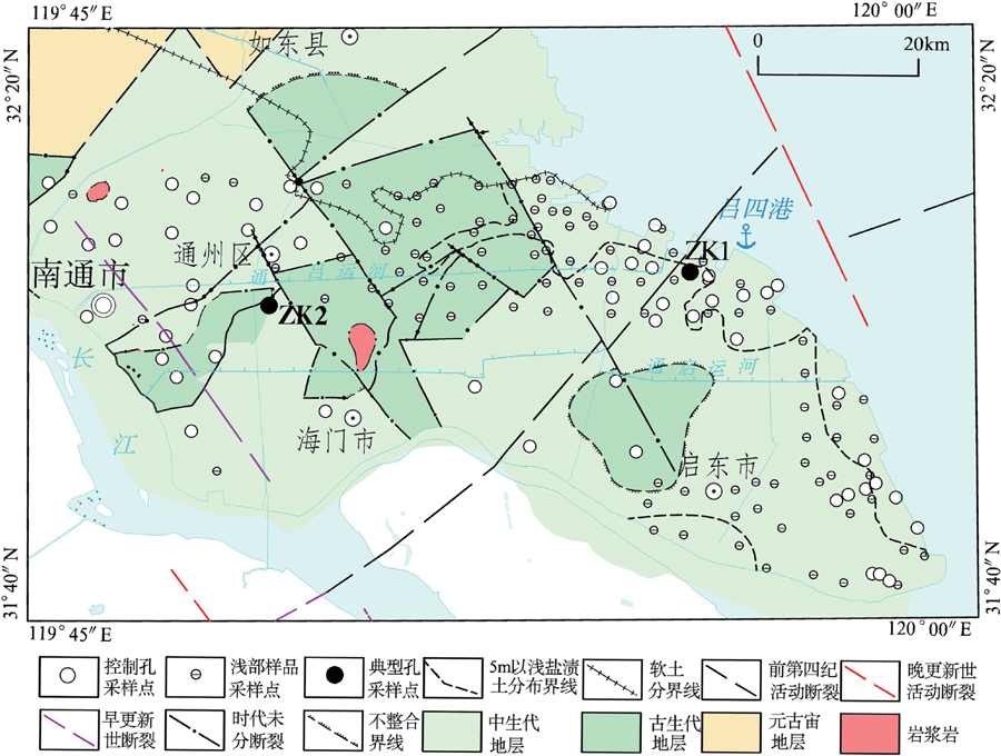
Fig.1 Geological and structural map of bedrock in the study area, showing the sampling locations
| 地层 | 工程地 质层组 | 层 号 | 岩土 名称 | 状态 | 厚度平 均值/m | 层顶埋深平 均值/m | 成因 类型 | 备注 | |
|---|---|---|---|---|---|---|---|---|---|
| 组 | 段 | ||||||||
| 如东组 (Qhr) | / | Ⅰ | 1-1 | 耕填土 | / | 0.65 | 0 | 人工 | / |
| 上段 | Ⅱ | 2-1 | 灰黄色粉土 | 稍密 | 1.92 | 0.60 | 河漫滩 | 两层土成因类型一致,仅岩性略有差异,2-2为本文新增土层 | |
| 2-2 | 灰黄色粉质黏土 | 可塑-软塑 | 1.51 | 0.55 | |||||
| 中段 | Ⅲ | 3-1 | 淤泥质粉质黏土 | 流塑 | 2.88 | 2.90 | 三角洲平原 沉积体系 | 由于3-3层、3-4层岩性和成因一致,仅密实程度不一致,且砂土渗透性好,盐分运移活跃,在经历千年渗透运移后,两层含盐特征基本一致,因此本文将两层合并分析,统称为3-3层 | |
| 3-2 | 灰色粉土,或互层土 | 稍密 | 5.21 | 2.81 | |||||
| 3-3 | 灰色粉砂 | 稍密 | 6.87 | 7.58 | |||||
| 3-4 | 灰色粉砂 | 中密 | 10.32 | 13.21 | |||||
| 3-5 | 灰色粉质黏土夹粉砂 | / | 6.63 | 19.70 | |||||
| 3-6 | 灰色粉土 | 中密 | 5.57 | 23.45 | |||||
| 下段 | Ⅳ | 4-1 | 淤泥质黏土夹薄层粉砂 | 流塑 | 13.08 | 25.67 | 前三角洲 | 4-3层仅在局部分布,本次的测试数据没有揭露到该层,本文不予研究 | |
| 4-2 | 灰色粉砂夹粉质黏土 | 稍密-中密 | 8.54 | 31.12 | 滨海-浅海 | ||||
| 4-3 | 灰色粉土 | 中密 | 10.17 | 34.24 | |||||
| 4-4 | 灰色粉质黏土夹粉土 | / | 8.74 | 41.49 | |||||
| 4-5 | 灰色粉砂 | 中密 | 9.05 | 50.33 | |||||
| 滆湖组 (Qpg) | 上段 | Ⅴ | 5-1 | 褐黄色粉质黏土 | 可塑-硬塑 | 4.00 | 36.78 | 河漫滩 | |
| 中段 | Ⅵ | 6-1 | 褐黄色-灰色粉质黏土 | 软塑-可塑 | 5.11 | 42.77 | 河漫滩 | 由于6-2层、6-3层及6-4层砂层渗透性好,且没有隔水层,盐分运移活跃,在经历万年渗透运移后,三层土含盐特征基本一致,因此本文将3层合并分析,统称为6-2层 | |
| 河床相 | |||||||||
| 6-2 | 灰色粉砂、细砂 | 密实 | 12.21 | 55.52 | |||||
| 6-3 | 灰黄色粗砂 | 密实 | 12.18 | 69.95 | |||||
| 6-4 | 灰色粉砂 | 密实 | 12.80 | 78.34 | |||||
| 下段 | Ⅶ | 7-1 | 灰褐色粉质黏土 | 可塑 | 8.11 | 76.09 | 河漫滩 | 7-2砂层、7-3砂层合并为7-2层进行分析,原因同上 | |
| 7-2 | 灰色粉砂、细砂 | 密实 | / | 81.29 | 河床相 | ||||
| 7-3 | 灰黄色粗砂 | 密实 | / | / | |||||
Table 1 Engineering geological layer division of the study area (<100 m depth)
| 地层 | 工程地 质层组 | 层 号 | 岩土 名称 | 状态 | 厚度平 均值/m | 层顶埋深平 均值/m | 成因 类型 | 备注 | |
|---|---|---|---|---|---|---|---|---|---|
| 组 | 段 | ||||||||
| 如东组 (Qhr) | / | Ⅰ | 1-1 | 耕填土 | / | 0.65 | 0 | 人工 | / |
| 上段 | Ⅱ | 2-1 | 灰黄色粉土 | 稍密 | 1.92 | 0.60 | 河漫滩 | 两层土成因类型一致,仅岩性略有差异,2-2为本文新增土层 | |
| 2-2 | 灰黄色粉质黏土 | 可塑-软塑 | 1.51 | 0.55 | |||||
| 中段 | Ⅲ | 3-1 | 淤泥质粉质黏土 | 流塑 | 2.88 | 2.90 | 三角洲平原 沉积体系 | 由于3-3层、3-4层岩性和成因一致,仅密实程度不一致,且砂土渗透性好,盐分运移活跃,在经历千年渗透运移后,两层含盐特征基本一致,因此本文将两层合并分析,统称为3-3层 | |
| 3-2 | 灰色粉土,或互层土 | 稍密 | 5.21 | 2.81 | |||||
| 3-3 | 灰色粉砂 | 稍密 | 6.87 | 7.58 | |||||
| 3-4 | 灰色粉砂 | 中密 | 10.32 | 13.21 | |||||
| 3-5 | 灰色粉质黏土夹粉砂 | / | 6.63 | 19.70 | |||||
| 3-6 | 灰色粉土 | 中密 | 5.57 | 23.45 | |||||
| 下段 | Ⅳ | 4-1 | 淤泥质黏土夹薄层粉砂 | 流塑 | 13.08 | 25.67 | 前三角洲 | 4-3层仅在局部分布,本次的测试数据没有揭露到该层,本文不予研究 | |
| 4-2 | 灰色粉砂夹粉质黏土 | 稍密-中密 | 8.54 | 31.12 | 滨海-浅海 | ||||
| 4-3 | 灰色粉土 | 中密 | 10.17 | 34.24 | |||||
| 4-4 | 灰色粉质黏土夹粉土 | / | 8.74 | 41.49 | |||||
| 4-5 | 灰色粉砂 | 中密 | 9.05 | 50.33 | |||||
| 滆湖组 (Qpg) | 上段 | Ⅴ | 5-1 | 褐黄色粉质黏土 | 可塑-硬塑 | 4.00 | 36.78 | 河漫滩 | |
| 中段 | Ⅵ | 6-1 | 褐黄色-灰色粉质黏土 | 软塑-可塑 | 5.11 | 42.77 | 河漫滩 | 由于6-2层、6-3层及6-4层砂层渗透性好,且没有隔水层,盐分运移活跃,在经历万年渗透运移后,三层土含盐特征基本一致,因此本文将3层合并分析,统称为6-2层 | |
| 河床相 | |||||||||
| 6-2 | 灰色粉砂、细砂 | 密实 | 12.21 | 55.52 | |||||
| 6-3 | 灰黄色粗砂 | 密实 | 12.18 | 69.95 | |||||
| 6-4 | 灰色粉砂 | 密实 | 12.80 | 78.34 | |||||
| 下段 | Ⅶ | 7-1 | 灰褐色粉质黏土 | 可塑 | 8.11 | 76.09 | 河漫滩 | 7-2砂层、7-3砂层合并为7-2层进行分析,原因同上 | |
| 7-2 | 灰色粉砂、细砂 | 密实 | / | 81.29 | 河床相 | ||||
| 7-3 | 灰黄色粗砂 | 密实 | / | / | |||||

Fig.2 Photos of engineering geological drilling cores
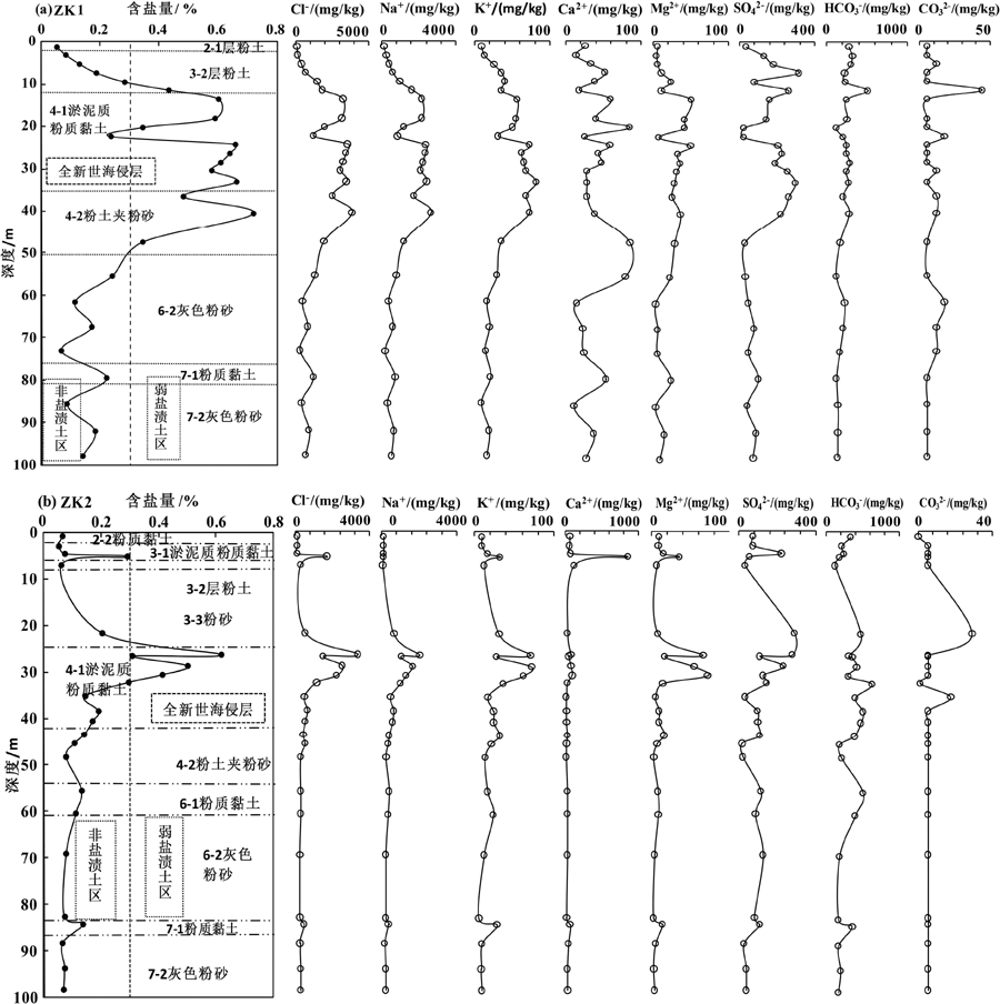
Fig.3 Typical soil layer salinity features in boreholes
| 层号 | 分区 | 含盐量/% | 各类型盐土类型占比/% | 按式(1)计算的 盐渍土占比/% | 按式(2)计算的 盐渍土占比/% | ||||||||||||
|---|---|---|---|---|---|---|---|---|---|---|---|---|---|---|---|---|---|
| 最大值 | 最小值 | 平均值 | 硫酸 | 亚硫酸 | 亚氯 | 氯 | 碱性 | 中盐 渍土 | 弱盐 渍土 | 非盐 渍土 | 碱性盐 渍土 | 非盐 渍土 | |||||
| 2-1 | W | 0.031 | 0.212 | 0.070 | 0 | 17 | 17 | 66 | 20 | 0 | 0 | 100 | 0 | 100 | |||
| 2-2 | W | 0.034 | 0.133 | 0.073 | 0 | 16 | 18 | 66 | 1 | 0 | 0 | 100 | 0 | 100 | |||
| 3-1 | A | 0.049 | 0.099 | 0.074 | 0 | 72 | 18 | 1 | 100 | 0 | 0 | 100 | 0 | 100 | |||
| 3-1 | B | 0.079 | 0.921 | 0.330 | 0 | 0 | 0 | 100 | 25 | 0 | 57 | 43 | 0 | 100 | |||
| 3-2 | A | 0.039 | 0.292 | 0.074 | 11 | 51 | 17 | 21 | 23 | 0 | 0 | 100 | 0 | 100 | |||
| 3-2 | B | 0.079 | 0.921 | 0.313 | 0 | 7 | 7 | 90 | 9 | 1 | 40 | 59 | 0 | 100 | |||
| 3-3 | W | 0.073 | 0.722 | 0.301 | 0 | 0 | 0 | 100 | 28 | 0 | 44 | 56 | 0 | 100 | |||
| 3-5 | A | 0.069 | 0.143 | 0.098 | 0 | 67 | 33 | 0 | 18 | 0 | 0 | 100 | 0 | 100 | |||
| 3-5 | B | 0.242 | 0.485 | 0.366 | 0 | 0 | 0 | 100 | 11 | 0 | 78 | 22 | 0 | 100 | |||
| 3-6 | W | 0.120 | 0.426 | 0.264 | 0 | 0 | 0 | 100 | 33 | 0 | 29 | 71 | 0 | 100 | |||
| 4-1 | A | 0.046 | 0.402 | 0.164 | 0 | 0 | 8 | 92 | 47 | 0 | 5 | 95 | 6 | 94 | |||
| 4-1 | B | 0.104 | 1.226 | 0.613 | 0 | 0 | 0 | 100 | 32 | 6 | 86 | 8 | 0 | 100 | |||
| 4-2 | A | 0.036 | 0.299 | 0.110 | 0 | 0 | 14 | 86 | 17 | 0 | 0 | 100 | 0 | 100 | |||
| 4-2 | B | 0.126 | 0.720 | 0.420 | 0 | 0 | 0 | 100 | 60 | 0 | 76 | 24 | 0 | 100 | |||
| 4-4 | A | 0.036 | 0.137 | 0.089 | 0 | 0 | 0 | 100 | 60 | 0 | 0 | 100 | 0 | 100 | |||
| 4-4 | B | 0.192 | 0.612 | 0.359 | 0 | 0 | 0 | 100 | 20 | 0 | 40 | 60 | 0 | 100 | |||
| 4-5 | A | 0.049 | 0.141 | 0.089 | 0 | 0 | 0 | 100 | 100 | 0 | 0 | 100 | 0 | 100 | |||
| 4-5 | B | 0.150 | 0.670 | 0.365 | 0 | 0 | 0 | 100 | 0 | 0 | 67 | 33 | 0 | 100 | |||
| 5-1 | W | 0.249 | 0.143 | 0.362 | 0 | 0 | 0 | 100 | 0 | 0 | 83 | 17 | 0 | 100 | |||
| 6-1 | A | 0.083 | 0.243 | 0.150 | 0 | 0 | 17 | 83 | 67 | 0 | 0 | 100 | 0 | 100 | |||
| 6-1 | B | 0.428 | 0.691 | 0.549 | 0 | 0 | 0 | 100 | 0 | 0 | 100 | 0 | 0 | 100 | |||
| 6-2 | W | 0.056 | 0.269 | 0.121 | 0 | 0 | 9 | 91 | 55 | 0 | 10 | 90 | 0 | 100 | |||
| 7-1 | A | 0.054 | 0.135 | 0.082 | 11 | 44 | 22 | 22 | 100 | 0 | 0 | 100 | 0 | 100 | |||
| 7-1 | B | 0.236 | 0.713 | 0.478 | 0 | 0 | 0 | 100 | 0 | 0 | 83 | 17 | 0 | 100 | |||
| 7-2 | W | 0.028 | 0.262 | 0.102 | 0 | 0 | 4 | 96 | 69 | 4 | 0 | 96 | 0 | 100 | |||
Table 2 Soil layer salinity classification statistics
| 层号 | 分区 | 含盐量/% | 各类型盐土类型占比/% | 按式(1)计算的 盐渍土占比/% | 按式(2)计算的 盐渍土占比/% | ||||||||||||
|---|---|---|---|---|---|---|---|---|---|---|---|---|---|---|---|---|---|
| 最大值 | 最小值 | 平均值 | 硫酸 | 亚硫酸 | 亚氯 | 氯 | 碱性 | 中盐 渍土 | 弱盐 渍土 | 非盐 渍土 | 碱性盐 渍土 | 非盐 渍土 | |||||
| 2-1 | W | 0.031 | 0.212 | 0.070 | 0 | 17 | 17 | 66 | 20 | 0 | 0 | 100 | 0 | 100 | |||
| 2-2 | W | 0.034 | 0.133 | 0.073 | 0 | 16 | 18 | 66 | 1 | 0 | 0 | 100 | 0 | 100 | |||
| 3-1 | A | 0.049 | 0.099 | 0.074 | 0 | 72 | 18 | 1 | 100 | 0 | 0 | 100 | 0 | 100 | |||
| 3-1 | B | 0.079 | 0.921 | 0.330 | 0 | 0 | 0 | 100 | 25 | 0 | 57 | 43 | 0 | 100 | |||
| 3-2 | A | 0.039 | 0.292 | 0.074 | 11 | 51 | 17 | 21 | 23 | 0 | 0 | 100 | 0 | 100 | |||
| 3-2 | B | 0.079 | 0.921 | 0.313 | 0 | 7 | 7 | 90 | 9 | 1 | 40 | 59 | 0 | 100 | |||
| 3-3 | W | 0.073 | 0.722 | 0.301 | 0 | 0 | 0 | 100 | 28 | 0 | 44 | 56 | 0 | 100 | |||
| 3-5 | A | 0.069 | 0.143 | 0.098 | 0 | 67 | 33 | 0 | 18 | 0 | 0 | 100 | 0 | 100 | |||
| 3-5 | B | 0.242 | 0.485 | 0.366 | 0 | 0 | 0 | 100 | 11 | 0 | 78 | 22 | 0 | 100 | |||
| 3-6 | W | 0.120 | 0.426 | 0.264 | 0 | 0 | 0 | 100 | 33 | 0 | 29 | 71 | 0 | 100 | |||
| 4-1 | A | 0.046 | 0.402 | 0.164 | 0 | 0 | 8 | 92 | 47 | 0 | 5 | 95 | 6 | 94 | |||
| 4-1 | B | 0.104 | 1.226 | 0.613 | 0 | 0 | 0 | 100 | 32 | 6 | 86 | 8 | 0 | 100 | |||
| 4-2 | A | 0.036 | 0.299 | 0.110 | 0 | 0 | 14 | 86 | 17 | 0 | 0 | 100 | 0 | 100 | |||
| 4-2 | B | 0.126 | 0.720 | 0.420 | 0 | 0 | 0 | 100 | 60 | 0 | 76 | 24 | 0 | 100 | |||
| 4-4 | A | 0.036 | 0.137 | 0.089 | 0 | 0 | 0 | 100 | 60 | 0 | 0 | 100 | 0 | 100 | |||
| 4-4 | B | 0.192 | 0.612 | 0.359 | 0 | 0 | 0 | 100 | 20 | 0 | 40 | 60 | 0 | 100 | |||
| 4-5 | A | 0.049 | 0.141 | 0.089 | 0 | 0 | 0 | 100 | 100 | 0 | 0 | 100 | 0 | 100 | |||
| 4-5 | B | 0.150 | 0.670 | 0.365 | 0 | 0 | 0 | 100 | 0 | 0 | 67 | 33 | 0 | 100 | |||
| 5-1 | W | 0.249 | 0.143 | 0.362 | 0 | 0 | 0 | 100 | 0 | 0 | 83 | 17 | 0 | 100 | |||
| 6-1 | A | 0.083 | 0.243 | 0.150 | 0 | 0 | 17 | 83 | 67 | 0 | 0 | 100 | 0 | 100 | |||
| 6-1 | B | 0.428 | 0.691 | 0.549 | 0 | 0 | 0 | 100 | 0 | 0 | 100 | 0 | 0 | 100 | |||
| 6-2 | W | 0.056 | 0.269 | 0.121 | 0 | 0 | 9 | 91 | 55 | 0 | 10 | 90 | 0 | 100 | |||
| 7-1 | A | 0.054 | 0.135 | 0.082 | 11 | 44 | 22 | 22 | 100 | 0 | 0 | 100 | 0 | 100 | |||
| 7-1 | B | 0.236 | 0.713 | 0.478 | 0 | 0 | 0 | 100 | 0 | 0 | 83 | 17 | 0 | 100 | |||
| 7-2 | W | 0.028 | 0.262 | 0.102 | 0 | 0 | 4 | 96 | 69 | 4 | 0 | 96 | 0 | 100 | |||
| 地层 | 层号 | 分区 | 样本数 | 埋深/m | 含盐量/ % | 离子含量/(mg/kg) | |||||||
|---|---|---|---|---|---|---|---|---|---|---|---|---|---|
| Na+ | K+ | Ca2+ | Mg2+ | HC | C | Cl- | S | ||||||
| 如东组 (Qhr) | 2-1 | 未分区 | 47 | 1.34 | 0.070 | 145 | 15 | 41 | 12 | 247 | 9 | 152 | 77 |
| 2-2 | 未分区 | 38 | 1.39 | 0.073 | 135 | 35 | 51 | 12 | 260 | 8 | 154 | 71 | |
| 3-1 | 低盐区 | 11 | 3.25 | 0.074 | 107 | 31 | 57 | 16 | 312 | 8 | 72 | 140 | |
| 3-1 | 高盐区 | 21 | 7.14 | 0.330 | 1 091 | 43 | 47 | 31 | 283 | 8 | 1 589 | 209 | |
| 3-2 | 低盐区 | 47 | 4.16 | 0.074 | 96 | 30 | 79 | 15 | 240 | 6 | 132 | 138 | |
| 3-2 | 高盐区 | 100 | 9.01 | 0.313 | 1 055 | 43 | 39 | 30 | 226 | 12 | 1 536 | 190 | |
| 3-3 | 未分区 | 36 | 11.65 | 0.301 | 976 | 47 | 42 | 38 | 208 | 15 | 1 468 | 212 | |
| 3-5 | 低盐区 | 3 | 6.50 | 0.098 | 165 | 61 | 48 | 25 | 354 | 5 | 103 | 222 | |
| 3-5 | 高盐区 | 9 | 11.45 | 0.366 | 1 210 | 50 | 31 | 42 | 205 | 11 | 1 969 | 141 | |
| 3-6 | 未分区 | 7 | 20.19 | 0.264 | 864 | 36 | 40 | 26 | 246 | 8 | 1 301 | 116 | |
| 4-1 | 低盐区 | 87 | 35.00 | 0.164 | 440 | 24 | 75 | 18 | 354 | 7 | 606 | 119 | |
| 4-1 | 高盐区 | 314 | 28.21 | 0.613 | 2 141 | 78 | 53 | 53 | 260 | 8 | 3 256 | 278 | |
| 4-2 | 低盐区 | 22 | 40.34 | 0.110 | 272 | 16 | 65 | 14 | 246 | 7 | 404 | 75 | |
| 4-2 | 高盐区 | 37 | 40.54 | 0.420 | 1 353 | 47 | 119 | 52 | 225 | 6 | 2 231 | 179 | |
| 4-4 | 低盐区 | 4 | 48.22 | 0.089 | 176 | 18 | 67 | 18 | 214 | 5 | 327 | 61 | |
| 4-4 | 高盐区 | 5 | 44.02 | 0.359 | 1 155 | 40 | 86 | 29 | 330 | 8 | 1 751 | 196 | |
| 4-5 | 低盐区 | 5 | 51.24 | 0.089 | 195 | 17 | 66 | 10 | 223 | 5 | 341 | 32 | |
| 4-5 | 高盐区 | 18 | 46.20 | 0.365 | 1 148 | 36 | 114 | 45 | 173 | 6 | 2 007 | 125 | |
| 滆湖组 (Qpg) | 5-1 | 未分区 | 12 | 30.31 | 0.362 | 1 208 | 19 | 79 | 30 | 248 | 2 | 1 875 | 157 |
| 6-1 | 低盐区 | 6 | 58.19 | 0.150 | 348 | 16 | 116 | 18 | 336 | 5 | 578 | 83 | |
| 6-1 | 高盐区 | 8 | 70.71 | 0.549 | 1 738 | 48 | 172 | 60 | 249 | 5 | 3 019 | 203 | |
| 6-3 | 未分区 | 11 | 65.20 | 0.121 | 348 | 14 | 52 | 11 | 178 | 7 | 534 | 65 | |
| 7-1 | 低盐区 | 9 | 84.47 | 0.082 | 102 | 23 | 95 | 13 | 328 | 5 | 130 | 128 | |
| 7-1 | 高盐区 | 24 | 84.24 | 0.478 | 1 474 | 48 | 200 | 52 | 227 | 6 | 2 485 | 291 | |
| 7-2 | 未分区 | 26 | 89.71 | 0.102 | 280 | 13 | 49 | 10 | 176 | 8 | 412 | 72 | |
Table 3 Statistics of soil salinity characteristics
| 地层 | 层号 | 分区 | 样本数 | 埋深/m | 含盐量/ % | 离子含量/(mg/kg) | |||||||
|---|---|---|---|---|---|---|---|---|---|---|---|---|---|
| Na+ | K+ | Ca2+ | Mg2+ | HC | C | Cl- | S | ||||||
| 如东组 (Qhr) | 2-1 | 未分区 | 47 | 1.34 | 0.070 | 145 | 15 | 41 | 12 | 247 | 9 | 152 | 77 |
| 2-2 | 未分区 | 38 | 1.39 | 0.073 | 135 | 35 | 51 | 12 | 260 | 8 | 154 | 71 | |
| 3-1 | 低盐区 | 11 | 3.25 | 0.074 | 107 | 31 | 57 | 16 | 312 | 8 | 72 | 140 | |
| 3-1 | 高盐区 | 21 | 7.14 | 0.330 | 1 091 | 43 | 47 | 31 | 283 | 8 | 1 589 | 209 | |
| 3-2 | 低盐区 | 47 | 4.16 | 0.074 | 96 | 30 | 79 | 15 | 240 | 6 | 132 | 138 | |
| 3-2 | 高盐区 | 100 | 9.01 | 0.313 | 1 055 | 43 | 39 | 30 | 226 | 12 | 1 536 | 190 | |
| 3-3 | 未分区 | 36 | 11.65 | 0.301 | 976 | 47 | 42 | 38 | 208 | 15 | 1 468 | 212 | |
| 3-5 | 低盐区 | 3 | 6.50 | 0.098 | 165 | 61 | 48 | 25 | 354 | 5 | 103 | 222 | |
| 3-5 | 高盐区 | 9 | 11.45 | 0.366 | 1 210 | 50 | 31 | 42 | 205 | 11 | 1 969 | 141 | |
| 3-6 | 未分区 | 7 | 20.19 | 0.264 | 864 | 36 | 40 | 26 | 246 | 8 | 1 301 | 116 | |
| 4-1 | 低盐区 | 87 | 35.00 | 0.164 | 440 | 24 | 75 | 18 | 354 | 7 | 606 | 119 | |
| 4-1 | 高盐区 | 314 | 28.21 | 0.613 | 2 141 | 78 | 53 | 53 | 260 | 8 | 3 256 | 278 | |
| 4-2 | 低盐区 | 22 | 40.34 | 0.110 | 272 | 16 | 65 | 14 | 246 | 7 | 404 | 75 | |
| 4-2 | 高盐区 | 37 | 40.54 | 0.420 | 1 353 | 47 | 119 | 52 | 225 | 6 | 2 231 | 179 | |
| 4-4 | 低盐区 | 4 | 48.22 | 0.089 | 176 | 18 | 67 | 18 | 214 | 5 | 327 | 61 | |
| 4-4 | 高盐区 | 5 | 44.02 | 0.359 | 1 155 | 40 | 86 | 29 | 330 | 8 | 1 751 | 196 | |
| 4-5 | 低盐区 | 5 | 51.24 | 0.089 | 195 | 17 | 66 | 10 | 223 | 5 | 341 | 32 | |
| 4-5 | 高盐区 | 18 | 46.20 | 0.365 | 1 148 | 36 | 114 | 45 | 173 | 6 | 2 007 | 125 | |
| 滆湖组 (Qpg) | 5-1 | 未分区 | 12 | 30.31 | 0.362 | 1 208 | 19 | 79 | 30 | 248 | 2 | 1 875 | 157 |
| 6-1 | 低盐区 | 6 | 58.19 | 0.150 | 348 | 16 | 116 | 18 | 336 | 5 | 578 | 83 | |
| 6-1 | 高盐区 | 8 | 70.71 | 0.549 | 1 738 | 48 | 172 | 60 | 249 | 5 | 3 019 | 203 | |
| 6-3 | 未分区 | 11 | 65.20 | 0.121 | 348 | 14 | 52 | 11 | 178 | 7 | 534 | 65 | |
| 7-1 | 低盐区 | 9 | 84.47 | 0.082 | 102 | 23 | 95 | 13 | 328 | 5 | 130 | 128 | |
| 7-1 | 高盐区 | 24 | 84.24 | 0.478 | 1 474 | 48 | 200 | 52 | 227 | 6 | 2 485 | 291 | |
| 7-2 | 未分区 | 26 | 89.71 | 0.102 | 280 | 13 | 49 | 10 | 176 | 8 | 412 | 72 | |
| 层号 | 岩性 | 分区 | pH | Cl-/ 2S | ESR | rMg/ rCa |
|---|---|---|---|---|---|---|
| 2-1 | 粉土 | 未分区 | 8.3 | 3.10 | 6 | 0.69 |
| 2-2 | 粉质黏土 | 未分区 | 8.1 | 4.20 | 5 | 0.50 |
| 3-1 | 淤泥质粉质黏土 | 低盐区 | 8.0 | 1.10 | 4 | 0.54 |
| 3-1 | 高盐区 | 8.2 | 11.90 | 31 | 1.06 | |
| 3-2 | 粉土 | 低盐区 | 8.0 | 2.30 | 4 | 0.46 |
| 3-2 | 高盐区 | 8.3 | 15.00 | 32 | 1.23 | |
| 3-4 | 粉砂 | 未分区 | 8.4 | 13.70 | 28 | 1.50 |
| 3-5 | 粉质黏土 | 低盐区 | 7.9 | 0.80 | 6 | 0.83 |
| 3-5 | 高盐区 | 8.5 | 23.70 | 34 | 2.33 | |
| 3-6 | 粉砂 | 未分区 | 8.2 | 21.50 | 27 | 1.22 |
| 4-1 | 淤泥质粉质黏土 | 低盐区 | 7.9 | 7.94 | 14 | 0.62 |
| 4-1 | 高盐区 | 8.2 | 21.70 | 53 | 1.76 | |
| 4-2 | 粉土夹粉砂 | 低盐区 | 8.1 | 8.90 | 11 | 0.44 |
| 4-2 | 高盐区 | 8.0 | 30.60 | 33 | 0.97 | |
| 4-4 | 粉质黏土夹粉砂 | 低盐区 | 7.7 | 6.80 | 5 | 0.43 |
| 4-4 | 高盐区 | 8.2 | 22.50 | 34 | 0.69 | |
| 4-5 | 粉砂夹粉土 | 低盐区 | 8.0 | 17.60 | 9 | 0.38 |
| 4-5 | 高盐区 | 8.0 | 28.70 | 27 | 0.72 | |
| 5-1 | 粉质黏土 | 未分区 | 7.9 | 27.50 | 32 | 0.80 |
| 6-1 | 粉质黏土 | 低盐区 | 7.9 | 18.10 | 10 | 0.40 |
| 6-1 | 高盐区 | 7.8 | 35.50 | 30 | 0.59 | |
| 6-3 | 粉砂 | 未分区 | 8.1 | 14.00 | 14 | 0.35 |
| 7-1 | 粉质黏土 | 低盐区 | 7.9 | 1.40 | 3 | 0.23 |
| 7-1 | 高盐区 | 7.8 | 12.10 | 27 | 0.49 | |
| 7-2 | 粉砂 | 未分区 | 8.0 | 8.30 | 11 | 0.32 |
Table 4 Statistics of environmental analysis indicators in various engineering geological layers
| 层号 | 岩性 | 分区 | pH | Cl-/ 2S | ESR | rMg/ rCa |
|---|---|---|---|---|---|---|
| 2-1 | 粉土 | 未分区 | 8.3 | 3.10 | 6 | 0.69 |
| 2-2 | 粉质黏土 | 未分区 | 8.1 | 4.20 | 5 | 0.50 |
| 3-1 | 淤泥质粉质黏土 | 低盐区 | 8.0 | 1.10 | 4 | 0.54 |
| 3-1 | 高盐区 | 8.2 | 11.90 | 31 | 1.06 | |
| 3-2 | 粉土 | 低盐区 | 8.0 | 2.30 | 4 | 0.46 |
| 3-2 | 高盐区 | 8.3 | 15.00 | 32 | 1.23 | |
| 3-4 | 粉砂 | 未分区 | 8.4 | 13.70 | 28 | 1.50 |
| 3-5 | 粉质黏土 | 低盐区 | 7.9 | 0.80 | 6 | 0.83 |
| 3-5 | 高盐区 | 8.5 | 23.70 | 34 | 2.33 | |
| 3-6 | 粉砂 | 未分区 | 8.2 | 21.50 | 27 | 1.22 |
| 4-1 | 淤泥质粉质黏土 | 低盐区 | 7.9 | 7.94 | 14 | 0.62 |
| 4-1 | 高盐区 | 8.2 | 21.70 | 53 | 1.76 | |
| 4-2 | 粉土夹粉砂 | 低盐区 | 8.1 | 8.90 | 11 | 0.44 |
| 4-2 | 高盐区 | 8.0 | 30.60 | 33 | 0.97 | |
| 4-4 | 粉质黏土夹粉砂 | 低盐区 | 7.7 | 6.80 | 5 | 0.43 |
| 4-4 | 高盐区 | 8.2 | 22.50 | 34 | 0.69 | |
| 4-5 | 粉砂夹粉土 | 低盐区 | 8.0 | 17.60 | 9 | 0.38 |
| 4-5 | 高盐区 | 8.0 | 28.70 | 27 | 0.72 | |
| 5-1 | 粉质黏土 | 未分区 | 7.9 | 27.50 | 32 | 0.80 |
| 6-1 | 粉质黏土 | 低盐区 | 7.9 | 18.10 | 10 | 0.40 |
| 6-1 | 高盐区 | 7.8 | 35.50 | 30 | 0.59 | |
| 6-3 | 粉砂 | 未分区 | 8.1 | 14.00 | 14 | 0.35 |
| 7-1 | 粉质黏土 | 低盐区 | 7.9 | 1.40 | 3 | 0.23 |
| 7-1 | 高盐区 | 7.8 | 12.10 | 27 | 0.49 | |
| 7-2 | 粉砂 | 未分区 | 8.0 | 8.30 | 11 | 0.32 |
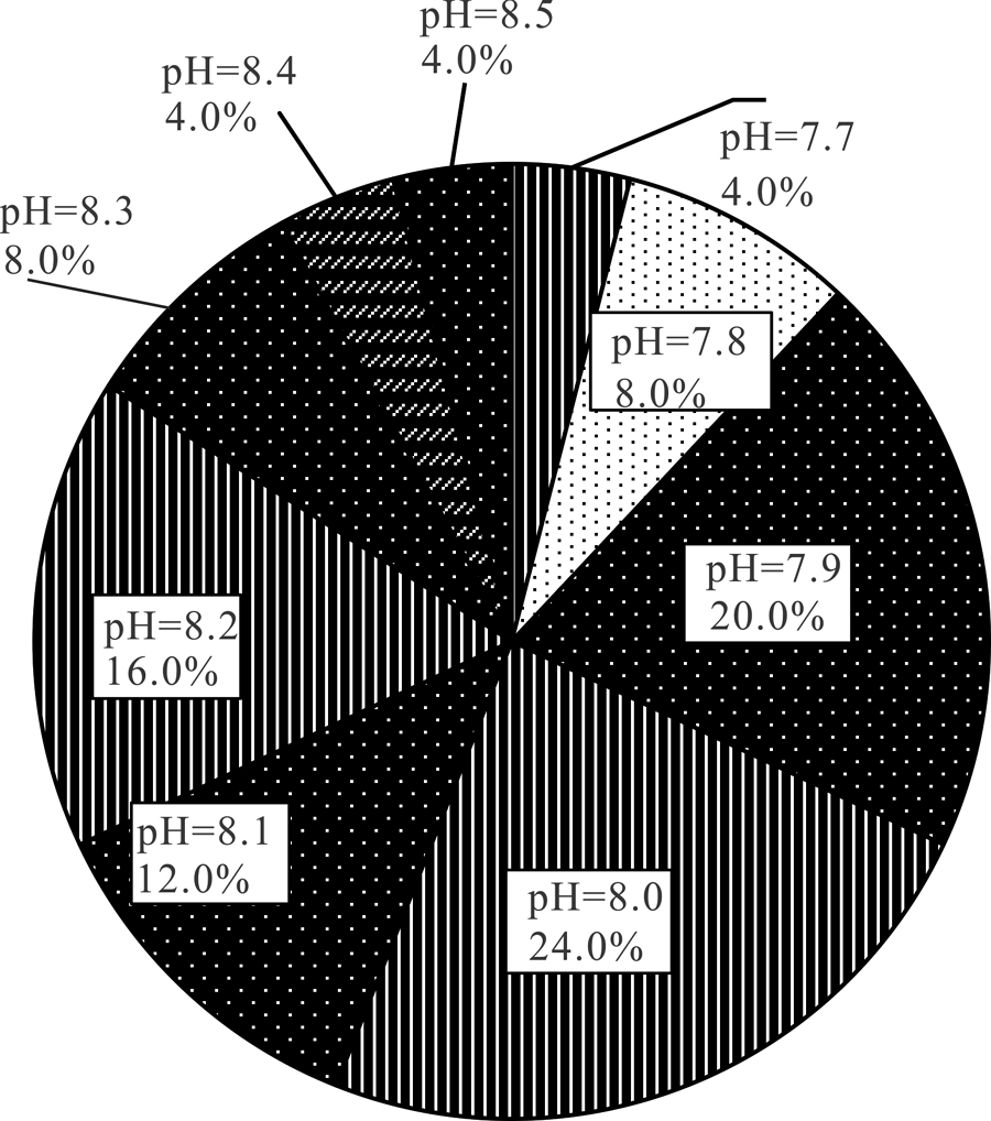
Fig.4 Soil pH classification statistics
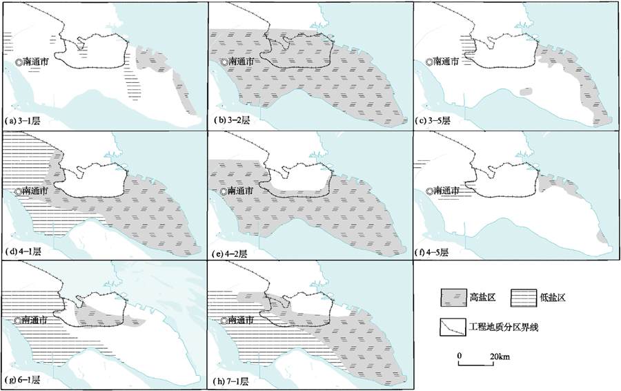
Fig.5 Maps of typical geological layers showing high/low salinity districts
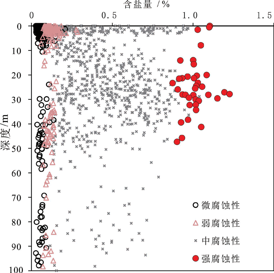
Fig.6 Corrosiveness and salt content conversion
| [1] | MAO Z C, SHEN H T, LIU T J, et al. Types of saltwater intrusion of the Changjiang Estuary[J]. Science in China Series B: Chemistry, 2001, 44(1): 150-157. |
| [2] | 乔吉果, 龙江平. 南通滨海地区海水入侵程度及影响因素探讨[J]. 贵阳学院学报(自然科学版), 2010, 5(3): 26-31. |
| [3] | 茅志昌, 沈焕庭, 徐彭令. 长江河口咸潮入侵规律及淡水资源利用[J]. 地理学报, 2000, 55(2): 243-250. |
| [4] | 张二凤, 陈沈良, 刘小喜. 长江口北支异常强盐水入侵观测与分析[J]. 海洋通报, 2014, 33(5): 491-496. |
| [5] | 吴辉, 朱建荣. 长江河口北支倒灌盐水输送机制分析[J]. 海洋学报, 2007, 29(1): 17-25. |
| [6] | LI L, ZHU J R, WU H. Impacts of wind stress on saltwater intrusion in the Yangtze Estuary[J]. Science China Earth Sciences, 2012, 55(7): 1178-1192. |
| [7] | LI L, ZHU J R, WU H, et al. Lateral saltwater intrusion in the north channel of the Changjiang estuary[J]. Estuaries and Coasts, 2014, 37(1): 36-55. |
| [8] | 王慧, 范文静, 张建立, 等. 中国沿海近31年冬季海平面变化特征[J]. 海洋通报, 2011, 30(6): 637-643. |
| [9] | 王慧, 刘克修, 范文静, 等. 2016年中国沿海海平面上升显著成因分析及影响[J]. 海洋学报, 2018, 40(2): 43-52. |
| [10] | 李攻科, 王卫星, 曹淑萍, 等. 天津滨海土壤盐分离子相关性及采样密度研究[J]. 中国地质, 2016, 43(2): 662-670. |
| [11] | GHASSEMI F, JAKEMAN A J, NIX H A. Salinization of Land and Water Resources:Human Causes, Extent, Management and Case Studies[M]. Canberra: UNSW Press, 1995: 1-3. |
| [12] | 王遵亲, 祝寿泉, 俞人培, 等. 中国盐渍土[M]. 北京: 科学出版社, 1993: 1-5. |
| [13] | 鲍道阳, 朱建荣. 近60年来长江河口河势变化及其对水动力和盐水入侵的影响Ⅱ.水动力[J]. 海洋学报, 2017, 39(2): 1-15. |
| [14] | 鲍道阳, 朱建荣. 近60年来长江河口河势变化及其对水动力和盐水入侵的影响Ⅲ.盐水入侵[J]. 海洋学报, 2017, 39(4): 1-15. |
| [15] | 朱建荣, 鲍道阳. 近60年来长江河口河势变化及其对水动力和盐水入侵的影响Ⅰ.河势变化[J]. 海洋学报, 2016, 38(12): 11-22. |
| [16] | 徐玉琳. 江苏省南通市深层含水系统地下水水质咸化特征及成因分析[J]. 中国地质灾害与防治学报, 2002, 13(2): 45-49. |
| [17] | 苟富刚, 龚绪龙, 杨磊, 等. 江苏沿海地区土体含盐特征及指示作用[J]. 长江流域资源与环境, 2018, 27(6): 1380-1387. |
| [18] | 李超, 李宏男. 考虑氯离子腐蚀作用的近海桥梁结构全寿命抗震性能评价[J]. 振动与冲击, 2014, 33(11): 70-77. |
| [19] | LI M, CHAI S X, DU H P, et al. Effect of chlorine salt on the physical and mechanical properties of inshore saline soil treated with lime[J]. Soils and Foundations, 2016, 56(3): 327-335. |
| [20] | 周洁, 李泽垚. 土体含盐量对长江口地区软黏土特性的影响[J]. 科学技术与工程, 2021, 21(8): 3274-3280. |
| [21] | 张同娟, 杨劲松, 刘广明. 基于EM38长江河口地区土壤盐渍化特征研究[J]. 水土保持学报, 2009, 23(6): 210-214. |
| [22] | 余世鹏, 杨劲松, 刘广明. 三峡调蓄条件下长江河口地区滨海滨江土壤盐渍化状况研究[J]. 土壤学报, 2009, 46(2): 235-240. |
| [23] | 谢文萍, 杨劲松. 三峡工程调蓄进程中长江河口区土壤水盐动态变化[J]. 长江流域资源与环境, 2011, 20(8): 951-956. |
| [24] | 苟富刚, 龚绪龙, 王光亚, 等. 长江三角洲北岸软土的不排水强度特征研究[J]. 水资源与水工程学报, 2018, 29(3): 225-230. |
| [25] | 许明, 陈建文, 雷宝华, 等. 南黄海海域中生代前陆盆地形成的构造背景[J]. 现代地质, 2019, 33(1): 13-24. |
| [26] | 苟富刚, 龚绪龙, 梅芹芹. 长江三角洲北岸土体工程地质层组划分及其应用[J]. 地质论评, 2018, 64(1): 237-245. |
| [27] | 中华人民共和国住房和城乡建设部,国家市场监督管理总局. 土工试验方法标准GB/T 50123-2019[S]. 北京: 中国计划出版社, 2019: 266-279. |
| [28] | 中华人民共和国住房和城乡建设部,国家市场监督管理总局. 盐渍土地区建筑技术规范GB/T 50942-2014[S]. 北京: 中国计划出版社, 2015: 2-7, 16-19. |
| [29] | 中华人民共和国住房和城乡建设部,国家市场监督管理总局. 岩土工程勘察规范GB50021-2001(2009年版)[S]. 北京: 中国建筑工业出版社, 2009: 82-84, 121-125. |
| [30] | 陈巍, 陈邦本, 沈其荣. 滨海盐土脱盐过程中pH变化及碱化问题研究[J]. 土壤学报, 2000, 37(4): 521-528. |
| [31] | 中华人民共和国住房城乡建设部.园林绿化工程盐碱地改良技术标准CJJT 283-2018[S]. 北京: 中国建筑工业出版社, 2018: 6-7. |
| Viewed | ||||||
|
Full text |
|
|||||
|
Abstract |
|
|||||